Showing 11018 items matching " land"
-
 Bendigo Historical Society Inc.
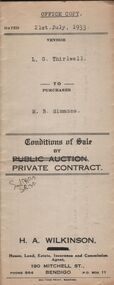
Document - H.A. & S.R. WILKINSON COLLECTION: CONTRACT OF SALE
This business was owned by father and son, Henry Archibald Wilkinson and Samuel Ronald "Ron" Wilkinson. Henry (1882-1954) was born in Shepparton and died in Bendigo. He was married to Grace Hovendon in 1908. Samuel Ronald "Ron" (1914-1995), Henry's son, was married to Florence Jean McKerlie in 1937.Conditions of sale by private contract dated 21st July, 1933 between L.G. Thirlwell (seller) and M.B. Simmons (buyer) for land having a frontage of about 109 feet to Hargreaves Street, Bendigo by a depth of 166 feet being the land described in residence area certificate no. 33019 in the books of the Mining Registrar at Bendigo, together with 6-roomed weatherboard dwelling and all sundry. Price 235 pounds.organization, business, h.a. & s.r wilkinson real estate -
 Kew Historical Society Inc
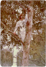
Photograph - Historic re-enactment during the Festival of Kew, 1978
At the 1978 Festival of Kew, a number of organisations, including the City of Kew, the Kew Historical Society, Trinity Boys Grammar School and local Girl Guides participated in a re-enactment of the expedition of the party of Charles Grimes in surveying the Yarra River as far as Kew in February 1803. The location for the event was Yarra Bend Park near the Studley Park Boat House. The event was organised by the Kew Historical Society. The re-enactment was captured by a number of amateur photographers as well as by a photographer from the local Progress Press.Local communities select events to commemorate according to their shared history and values. Commemorations of colonial exploration were popular with local historical groups such as the Kew Historical Society in the twentieth century. In re-enacting events such as the Grimes survey of the Yarra, students from a local school were encouraged to take on specific roles, including play-acting individuals involved in the survey party as well as members of the local Wurundjeri People. The photographs, taken by amateur and professional photographers, represent a period in time when the dominant values were those shared by the descendants of European settlers in Victoria. Original colour photographic positive showing a boy from Trinity Grammar School in a tree, role-playing Captain Robbins, a member of Grimes' survey party.Annotated on reverse: "CAPTAIN ROBBINS LOOKING UP THE YARRA AND REPORTING: 'A LAND THAT OFFERS GREAT OPPORTUNITY FOR SETTLEMENT' / RE-ENACTED BY A TRINITY BOY / 1978 FESTIVAL"kew historical society, trinity grammar school, kew girl guides, city of kew, yarra river, charles grimes, collins expedition, wurundjeri people, yarra bend park, colonial surveys, historic re-enactments, festival of kew, kew festival -
 Mission to Seafarers Victoria
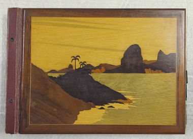
Album - Photographic album, 1948
This item provides a picture of the route taken by the M/V Fenris.The album provides an insight into the ways of life in many different port cities of North and South America as well as Europe. Photograph album with wooden covers with 31 pages of photos, many loose. Depicts journey by Allan Quinn while aboard the M/V Fenris in 1948-1949. Inside front cover contains handwritten itinerary of the voyage. Cover is made of brown wood with inset wooden picture of sea and land. Back cover is plain.fenris, voyage, album, photographs, allan quinn, seamen, sailors, seafarers -
 Ringwood and District Historical Society
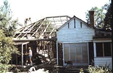
Photograph, Frazer's orchard 'Alkoomi' North Ringwood - Farm house demolition c1971
Harold Frazer’s “Alkoomi” orchard farm house, Oban Rd Nth Ringwood, undergoing demolition after land was sold to A.V. Jennings for housing development. Circa 1971 -
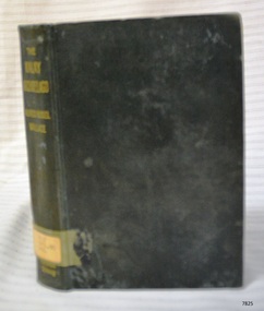 Flagstaff Hill Maritime Museum and Village
Book, The Malay Archipelago
This item is from the ‘Pattison Collection’, a collection of books and records that was originally owned by the Warrnambool Mechanics’ Institute, which was founded in Warrnambool in 1853. By 1886 the Warrnambool Mechanics’ Institute (WMI) had grown to have a Library, Museum and Fine Arts Gallery, with a collection of “… choice productions of art, and valuable specimens in almost every branch and many wonderful national curiosities are now to be seen there, including historic relics of the town and district.” It later included a School of Design. Although it was very well patronised, the lack of financial support led the WMI in 1911 to ask the City Council to take it over. In 1935 Ralph Pattison was appointed as City Librarian to establish and organise the Warrnambool Library as it was then called. When the WMI building was pulled down in 1963 a new civic building was erected on the site and the new Warrnambool Library, on behalf of the City Council, took over all the holdings of the WMI. At this time some of the items were separated and identified as the ‘Pattison Collection’, named after Ralph Pattison. Eventually the components of the WMI were distributed from the Warrnambool Library to various places, including the Art Gallery, Historical Society and Flagstaff Hill. Later some were even distributed to other regional branches of Corangamite Regional Library and passed to and fro. It is difficult now to trace just where all of the items have ended up. The books at Flagstaff Hill Maritime Village generally display stamps and markings from Pattison as well as a variety of other institutions including the Mechanics’ Institute itself. RALPH ERIC PATTISON Ralph Eric Pattison was born in Rockhampton, Queensland, in 1891. He married Maude Swan from Warrnambool in 1920 and they set up home in Warrnambool. In 1935 Pattison accepted a position as City Librarian for the Warrnambool City Council. His huge challenge was to make a functional library within two rooms of the Mechanics’ Institute. He tirelessly cleaned, cleared and sorted a disarrayed collection of old books, jars of preserved specimens and other items reserved for exhibition in the city’s museum. He developed and updated the library with a wide variety of books for all tastes, including reference books for students; a difficult task to fulfil during the years following the Depression. He converted all of the lower area of the building into a library, reference room and reading room for members and the public. The books were sorted and stored using a cataloguing and card index system that he had developed himself. He also prepared the upper floor of the building and established the Art Gallery and later the Museum, a place to exhibit the many old relics that had been stored for years for this purpose. One of the treasures he found was a beautiful ancient clock, which he repaired, restored and enjoyed using in his office during the years of his service there. Ralph Pattison was described as “a meticulous gentleman whose punctuality, floorless courtesy and distinctive neat dress were hallmarks of his character, and ‘his’ clock controlled his daily routine, and his opening and closing of the library’s large heavy doors to the minute.” Pattison took leave during 1942 to 1945 to serve in the Royal Australian Navy, Volunteer Reserve as Lieutenant. A few years later he converted one of the Museum’s rooms into a Children’s Library, stocking it with suitable books for the younger generation. This was an instant success. In the 1950’s he had the honour of being appointed to the Victorian Library Board and received more inspiration from the monthly conferences in Melbourne. He was sadly retired in 1959 after over 23 years of service, due to the fact that he had gone over the working age of council officers. However he continued to take a very keen interest in the continual development of the Library until his death in 1969. The Pattison Collection, along with other items at Flagstaff Hill Maritime Village, was originally part of the Warrnambool Mechanics' Institute’s collection. The Warrnambool Mechanics’ Institute Collection is primarily significant in its totality, rather than for the individual objects it contains. Its contents are highly representative of the development of Mechanics' Institute libraries across Australia, particularly Victoria. A diversity of publications and themes has been amassed, and these provide clues to our understanding of the nature of and changes in the reading habits of Victorians from the 1850s to the middle of the 20th century. The collection also highlights the Warrnambool community’s commitment to the Mechanics’ Institute, reading, literacy and learning in the regions, and proves that access to knowledge was not impeded by distance. These items help to provide a more complete picture of our community’s ideals and aspirations. The Warrnambool Mechanics Institute book collection has historical and social significance for its strong association with the Mechanics Institute movement and the important role it played in the intellectual, cultural and social development of people throughout the latter part of the nineteenth century and the early twentieth century. The collection of books is a rare example of an early lending library and its significance is enhanced by the survival of an original collection of many volumes. The Warrnambool Mechanics' Institute’s publication collection is of both local and state significance. The Malay Archipelago The Land of the Orang-Utan and the Bird of Paradise. A narrative of the travel with studies of Man and Nature Author: Alfred Russel Wallace Publisher: MacMillan and Co Date: 1890Label on spine cover with typed text PAT 915.95 WAL Pastedown front endpaper has sticker from Warrnambool Mechanics Institute and Free Library covered by a sticker from Corangamite Regional Library Service Front loose endpaper has a stamp from Corangamite Regional Library Servicewarrnambool, shipwrecked-coast, flagstaff-hill, flagstaff-hill-maritime-museum, maritime-museum, shipwreck-coast, flagstaff-hill-maritime-village, shipwrecked-artefact, book, pattison collection, warrnambool library, warrnambool mechanics’ institute, ralph eric pattison, corangamite regional library service, warrnambool city librarian, mechanics’ institute library, victorian library board, warrnambool books and records, warrnambool children’s library, great ocean road, the malay archipelago, alfred russel wallace -
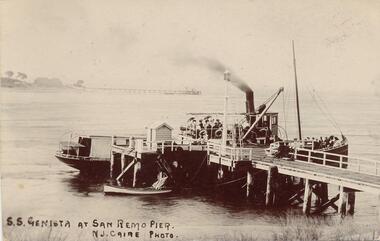 Phillip Island and District Historical Society Inc.
Photograph - Post Card, Late 1800's or early 1900's
Donated by Edith ElmsBlack & White Postcard of the S.S. Genista moored at San Remo Pier with passenger aboard. Also small sailing boat moored at pier. Newhaven land and pier in background."S.S. Genista at San Remo Pier". "N. J. Caire Photo." Letter on back of card from Eily to her Aunty written from San Remo.san remo pier, s.s. genista, newhaven phillip island, phillip island, edith elms -
 Phillip Island and District Historical Society Inc.
Newspaper Clipping, 28/11/1968
Articles from a collection of newspaper clippings from October 1968 to July 1971Three articles:- 1. Problem with the Phillip Island Teenage Club behaviour. 2. Problem of unsightly toilets on vacant land. 3. Erosion of soil in mutton bird rookeries.phillip island, mutton birds, phillip island teenage club, toilets -
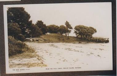 Phillip Island and District Historical Society Inc.
Photograph, George Cox's Shed, Cowes Beach, Phillip Island, 1914
George Cox was in Gibraltar with the British Navy when he heard about "gold" in Australia. In his latter days, as the mailman, he was granted a fisherman's license which enabled him to build a hut on the foreshore below the Isle of Wight and eastward of the Jetty. This is shown in the photograph.Scene of beach and tongue of land leading to the beach. The Jetty shed is mostly obscured by trees. George Cox's hut is tucked into the sweep of corner on the foreshore, large trees behind it.The Rose Series P 673 Near the pier Cowes, Phillip Island, Victorialocal history, photographs, george cox's hut, cowes foreshore, sepia photograph, betty kus collection, george cox, mailman, foreshore hut, phillip island, bruce bennett -
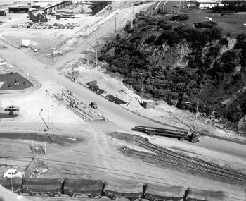
 Glenelg Shire Council Cultural Collection
Photograph - Photograph - aerial view of Portland coast, c. 1954
Black and white aerial photograph of coastline around Portland. Black border, scale all sides, 5 rows of 3 't' at regular intervals. Ocean, land with lakesFront: '820 -8' - handwritten, white, lower border 'RUN 5' 'PORTLAND', printed, white, lower borderaerial photography, central portland, portland harbour, south west coastline -
Federation University Historical Collection
Petition, John Ferres, Government Printer, Petition: John Dunmore Lang D.D., 1857, 10/12/1856 12/12/1857
.1) Two page blue foolscap printed page .2) 51 page (+ appendix) blue foolscap report from the Select Committee upon land and Drake's case petition, john dunmore lang, drake, james marshall, robery underwood, william patterson, j. badcock, joseph l'estrange, j. waterfield -
 Glenelg Shire Council Cultural Collection
Photograph - Photograph - Portland Harbour, 1960-1966
Port of Portland Authority archivesFront: (no inscriptions) Back: (no inscriptions)port of portland archives -
 Bendigo Historical Society Inc.
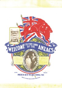
Document - ABBOTT COLLECTION: MEMORABILIA
Found inside the Abbott family Bible, a small leaflet titled 'Welcome to the land of the Anzacs' in aid of the Anzac Memorial Fund. Issued by Victorian Branch Returned Soldiers League.societies, order of .., returned soldiers league -
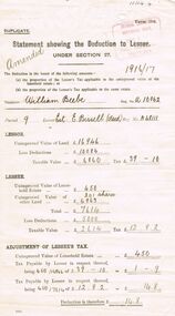 Bendigo Historical Society Inc.
Document - GLENYS MCKITTERICK COLLECTION: WILLIAM BEEBE DOCUMENTS, 19th June, 1917
Buff coloured document, flimsy. Statement showing the deduction to Lessee. Issued to William Beebe, A/10062, Estate of E. Bissell ( Decd), A48111. UCV of land 16,946 pounds.person, bendigo, william beebe -
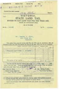 Bendigo Historical Society Inc.
Document - BUSH COLLECTION: TAX AND RATE NOTICES, 1920 - 1930
Collection of approximately 24 tax and rate notices pertaining to S. A. Bush. Includes State income tax and Land Tax, Federal Income Tax, City of Bendigo rates.person, individual, bush collection - personal -
 Bendigo Historical Society Inc.
Book - IN A PICTURE LAND OVER THE SEA, c1998
In a Picture land over the sea. Publisher: Author and Bendigo Art Gallery. Printed by: Print Creations, Bendigo. ISBN:0949215163. 76 pages. Photographs, illustrations some in colour.Karen Quilanart, lifestyle, portrait -
 Bendigo Historical Society Inc.
Document - PLANS FROM LAND OFFICE , BENDIGO
Royal Historical Society of Victoria Bendigo and district branch. Plans from Land office, Bendigo. Four pages listing of parishes and two pages listing of Township plans. -
Port Melbourne Historical & Preservation Society
Archive - File, Ewan Ogilvy's Bayside Papers, Box Two: Bayside Press Cuttings, 1987
Ewan OGILVY, former Melbourne Councillor and also of Community Services Victoria, Inner Urban Ministerial Advisory Committee and Uniting Church's Centre for Urban Research and Action (CURA), was instrumental in social justice approaches to town planning. He and CURA's Social Justice and the City Project funded Port Melbourne community groups protesting against the SCDC development in 1987. His files were presented to the Society in May 2001 on his preparation for leaving Victoria.From Ewan OGILVY's chronologically organised 'Bayside Papers' relating to the proposed development of Port Melbourne industrial land in the late 1980s, bound file: 'Bayside' press cuttingsAll items signed 'Ewan Ogilvy'town planning, town planning - proposals shelved - bayside, public action campaigns, environmental issues, public housing, missions to seamen, centre for urban research and action, sandridge city development co pty ltd, scdc, linton r lethlean, ewan ogilvy, barry pullen -
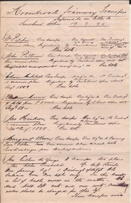 Bendigo Historical Society Inc.
Document - CONNELLY, TATCHELL, DUNLOP COLLECTION: DOCUMENTS FOR KOONDROOK TRAIN
Documents and letters from Connelly and Tatchell solicitors, Sandhurst and Kerang, regarding costs and land transfers for the Koondrook train or tramway. There are 29 documents dated from 1888 to 1889.organization, public utility, transport -
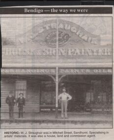 Bendigo Historical Society Inc.
Newspaper - JENNY FOLEY COLLECTION: HISTORIC
Bendigo Advertiser "The way we were" from 1999. Historic: W.J. Straughair was in Mitchell Street, Sandhurst. Specialising in artists' materials, it was also a house, land and commission agent.newspaper, bendigo advertiser, the way we were -
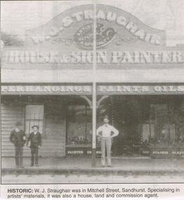 Bendigo Historical Society Inc.
Newspaper - JENNY FOLEY COLLECTION: HISTORIC
Bendigo Advertiser "The way we were" from 1999. Historic: W.J. Straughair was in Mitchell Street, Sandhurst. Specialising in artists materials, it was also a house, land and commission agent.newspaper, bendigo advertiser, the way we were -
 National Vietnam Veterans Museum (NVVM)
Photograph, Various Weapons
Framed coloured photo of what appears to be captured weapons including a rocket launcher, serveral rockets and land mines. civilian men, women and children can be seen in the background.photograph, weapons -
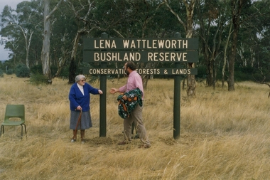 Clunes Museum
Photograph
A CORNER BLOCK OF BUSHLAND NAMED LENA WATTLEWORTH BUSHLAND RESERVE.COLOUR PHOTOGRAPH LENA WATTLEWORTH BUSHLAND RESERVE CONSERVATION FORESTS AND LAND. PHOTO TAKEN TALBOT ROAD. MRS WATTLEWORTH DURING THE PRESENTATION. PHOTGRAPH MOUNTED ON WHITE CARDBOARD.local history, photography, photographs, weickhardt, wattleworth -
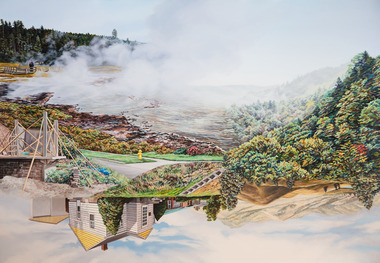 Nillumbik Shire Council
Painting: Kevin CHIN, Kevin Chin, Castle Under the Sky, 2018
This painting was sparked by a US studio residency at Yellowstone National Park, shortly after Trump’s election. In America, Chin witnessed conservative nationalism and divisiveness, but also an equal reaction promoting diversity and challenging structural inequality. Developing this work in Australia, Chin examined how a sense of place forms fluidly in the consciousness, to surpass geographic borderlines.Kevin Chin is a local artist. He has been a finalist in the Nillumbik Prize for Contemporary Art (2015, 2019). In this painting Chin explores economic, cultural and social structures that shape the world in which we live, questioning who has built what, who takes ownership, and who has the right to the land. Landscape painting depicting a house (upside down) and a half finished urban structure sitting amongst mountain peaks and land that has been cleared and immersed in fog/smoke.N/Alandscape, kevin, chin, structural, inequality, castle, trump, painting, nillumbik, residency, yellowstone, realism, oils -
Whitehorse Historical Society Inc.
Document, Notes on history of the Taintons of East Burwood, n.d
Notes by Ken Smith, descendant of the Tainton Family. James and Ann Tainton arrived in Australia in 1853, bought land between Hawthorn and Burwood Roads near Blackburn Road.tainton family, tainton, james, tainton, ann, tainton road, burwood east -
Whitehorse Historical Society Inc.
Map, Cadastral Map System, 2005
Land Victoria map of section of Blackburn North.Land Victoria map of section of Blackburn North, inc. Middleborough Road, Joseph Street and Chapman Street. Scale: 1:1500. With Lot Nos. and block frontage dimensions.Land Victoria map of section of Blackburn North. middleborough road, blackburn north, joseph street, blackburn north, chapman street, blackburn north -
Whitehorse Historical Society Inc.
Newspaper - Article, Death notice of John Allan Matheson, 2/02/1995
Notice of death and memorial service for John Allan Matheson, younger son of Captain Charles and Mary Matheson. Matheson land bought by City of Nunawading for the bi-centennial orchard.matheson, john allan -
 Whitehorse Historical Society Inc.
Document - Extract of Land Conveyance, Patrick Riley, 9/5/1870
Photocopy of extract of Memorial Book of conveyance dated 9/5/1870 for sale of land in the Parish of Nunawading. Sold by James Coyne Riley to Patrick Riley. 3 pages.land sales;, riley, patrick, james coyne -
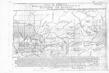 Whitehorse Historical Society Inc.
Map, Plan of locality, 1855-60?
'Plan of locality, showing the whole line of route to the district from Melbourne by way of Nunawading and Bulleen. 2,000 acres for sale... Thomas Ham, Land Agent [ 1855 - 60?]nunawading, bulleen, barkers track, land sales -
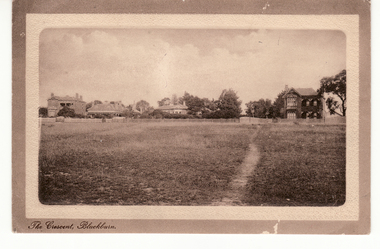 Whitehorse Historical Society Inc.
Postcard - Black and white postcard, The Crescent Blackburn (Now Gordon Crescent)
Sepia postcard entitled 'The Crescent, Blackburn'.ow Gordon Crescent, Blackburn. Picture shows Victorian and Edwardian homes.|Probably these homes were part of the land boom of the 1890s.hooke, janet emily, albert arthur, the crescent, blackburn, gordon crescent -
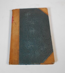 Bendigo Historical Society Inc.
Administrative record - Report of sales by auction 1877-1898
Book with greenish/blueish cover, brown leather spine and corners. The book covers land sales by auction for the years 1877 to 1898. The sales are listed under Town and County.On the spine red label with gold letters: "Reports of sales by auction" also on the spine in red texter the number 7, in black the letter E and 1877 to 1898land sales, auctions, 1877-1898