Showing 10723 items
matching sites
-
 Parks Victoria - Days Mill and Farm
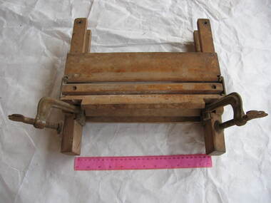
Mangle frame, post 1868
Found, stored on-site.Wooden frame with inscriptions, mainly indecipherable. Has vice on each side at base. No rollers. See mangle rollers DM3163 and DM2977, these fit into frame."PATENT / Sept.3. 1867 / may 13 1868 -
 Parks Victoria - Days Mill and Farm
Domestic object - Bath
Possibly made on-siteof critical significance GALVANIZED METAL BATH. Rectangular shaped bath, with rounded ends, turned rim. Roughly soldered. Consisting of a wood & iron frame with 4 claw feet & plug. Decorative floral motif on upright supports joining to claw feet.bathing -
 University of Melbourne, Burnley Campus Archives
Plan, Royal Horticultural Society's Garden
Changed boundaries of the site burnley gardens, survey paddock, flood, lynch design, richmond park, yarra river -
 Lakes Entrance Historical Society
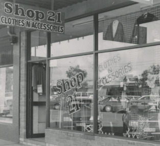
Photograph - Businesses, 1991
Established at this site 19.6.1991Black and white photograph of exterior of Shop 21 Clothing store when situated at 21 Myer Street Lakes Entrancebusinesses, commerce -
 Hume City Civic Collection
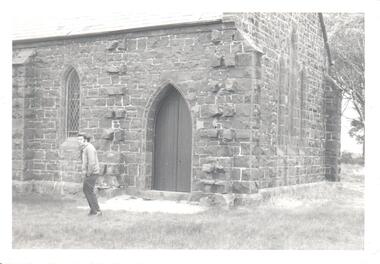
Photograph, pre 1970
The photograph of St Mary's Anglican Church at Bulla was taken before the completion of the airport at Tullamarine. Originally the church occupied a site on Oaklands Road near the Old Bulla Road. It was shifted to its present site in Bulla next to the old council chambers when the airport was built because the old site was near an important runway.A black and white photograph of a partial view of a bluestone church showing a rear and side view. There are three simple pointed arch windows across the restry and one on the side wall and a wooden door leading into the vestry.st mary's anglican church, bluestone buildings, george evans collection -
 Eltham District Historical Society Inc
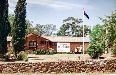
Photograph, Eltham RSL and Uniting Church, Main Road, Eltham, 1979c
Once a row of shops wase situated here and then the Eltham RSL sub branch occupied this site from the 1950s. The War Memorial obelisk was relocated here from it oriiginal site and situated in front of the building. After the branch amalgamated with Montmorency in 2012, the building was subsequently sold and demolished. The memorial was relocated. Units now occupy the site. Changing streetscapeRoll of 35mm colour negative film, 6 stripsUnidentified; half-frame numberingmonuments, church, eltham rsl sub-branch, eltham uniting church, main road -
 Lakes Entrance Historical Society
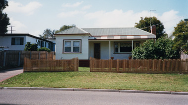
Photograph - Historic House, 2000
Part of a larger dwelling originally situated 607 Esplanade, (now site of Golden Beach Motel), other half moved to Lake Tyers Beach Road. This section moved to present site around 1965 by Ray Curry. Various residents Misses Phillips (original site) George Ward, R A and K D Bills from 1993.Colour photograph of a weatherboard dwelling with hip roof situated at 15 Coates Road. Has a bull nose veranda across front entry, oiled timber picket fence. Lakes Entrance Victoriahouses, fences, heritage study -
 Ringwood and District Historical Society
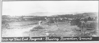
Photograph, Birds eye view East Ringwood - Showing Recreation Ground. Mt. Dandenong Rd. on right. Taken from present Civic Centre site. Football final in progress - 1923
Written below photograph, "Birds eye view East Ringwood - Showing Recreation Ground". Typed below photograph, "Mt. Dandenong Rd. on right. Taken from present Civic Centre site. Football final in progress - 1923". -
 Ringwood and District Historical Society
Newspaper, Scrapbook Clipping, Library Collection, Ringwood, Victoria
Newspaper Clipping from "The Mail", 17-12-96, Page 5 . 'Sports plan is rejected' - By Jamie DuncanMaroondah Council has knocked back Yarra Valley Anglican School's plans to build an indoor sports complex on its Kalinda Rd site. Nearby residents were concerned abou the potential noise and visual impact of the stadium. -
 Stawell Historical Society Inc
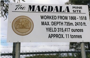
Photograph, Kevin Patterson, Magdala Mine Site sign and Shaft, Circa 1999
3 Colour Photgraphs: 2 showing information about the mine , the other showing the shaft covered with protecive mesh.Sthe Sign Reads: The Magdala mine site worked from 1868 -1918. Max Depth 735 M. 2410 ft. Yeild 315,417 Ounces Approx 11 Tonnes On Revese: Gold Miners Stawell. Neg 20 mining, magdala -
 Queenscliffe Maritime Museum
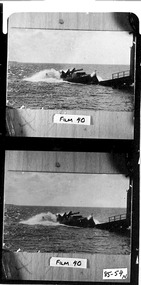
Photograph - Black & white photograph of lifeboat Queenscliffe launching, Photographer unknown, Photographs
Photos of the lifeboat QueenscliffeRealism, historicalBlack & white photographs of the lifeboat Queenscliffe launching from the lifeboat shed On the reverse - "P6A53 - lifeboat being launched [c1936] from the old fisherman's pier, north of the present pier boat shed dismantled & transferred to the present site on new pier because of sanding up preventing launch c1947-49 "" -
 Wodonga & District Historical Society Inc
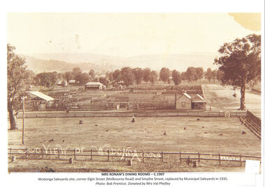
Photograph - Mrs Ronan's Dining Rooms
Before the construction of the Wodonga Municipal Saleyards which opened in 1935, there were four private saleyards which operated in Wodonga. They were owned by Gippsland & Northern Co-Operative Co. Ltd., Dalgety & Co., New Zealand Loan & Mercantile Agency Co. Ltd. and Younghusband Ltd. When Mrs Julia Ronan nee Arundel lost her husband John to tuberculosis in 1906, she quickly decided to move from their small farm into Wodonga with her 3 children. She was granted the lease of the ground she needed to establish her eating house at one shilling per year in a shed on the Dalgety's saleyard block. Two established merchants Albert Schlink and John Whan and butcher Jack Garrett agreed to allow her credit which enabled her to open Ronan's Dining Rooms at the Saleyards. It was often a challenging environment, with drovers, and horse- breakers, auctioneers and bushmen bringing huge mobs of cattle and horses to the saleyards. Stories of the premises include the unexpected arrival in the passage of a lively bullock which finished up on the girls' bed. Mrs Ronan persevered and beat all obstacles to finally move from the saleyards to the Wodonga Coffee Palace in High Street, beside the railway gates in 1921.This item is significant because it captures one of the private saleyards which operated prior to the establishment of the Wodonga Municipal Saleyards.A black and white image of the sale yards at Wodonga c1907 with the dining room operated by Mrs Ronan on the right.Beneath image: View of Wodonga Mrs Ronan's Dining c1907 Wodonga Sale site, Corner Elgin (Melbourne Road) and Smythe Street, replaced by Municipal Saleyards in 1935. Photo: Bob Prentice, Donated by Mrs Val Phefleywodonga saleyards, mrs julia ronan -
 Ringwood and District Historical Society
Photograph, Maroondah Highway West, Ringwood- c1920. Original Ringwood Market, Cnr. Maroondah Highway and Ringwood Street
Black and white photograph of wooden building. (2 copies)Typed under one copy: "Original Ringwood market and saleyards at corner of Maroondah Hwy and Ringwood St.. Charter St is beyond saleyards on right. SEC office now occupies site of buildings seen. c1920" Typed under second copy: "Original Ringwood market cnr Maroondah Highway and Ringwood St. opposite present clock tower site. 1920. Now SEC office. Sign on building reads- "Ringwood Market. D.G. McClelland & Co.. Stock Station Land Estate Agents. Alex McClelland, Auctioneer. -
 Greensborough Historical Society
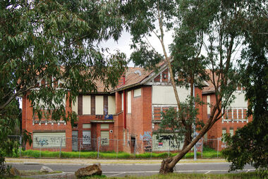
Photograph - Digital Image, Marilyn Smith, Buildings in Quasar Court (Larundel), 05/09/2017
This photograph shows buildings in Quasar Court at the old Larundel Hospital site. Some buildings on this site are heritage listed on the Victorian Heritage Database. The Quasar Court buildings will be renovated into apartments. Digital copy of colour photographlarundel hospital, quasar court bundoora -
 Bright & District Historical Society operating the Bright Museum
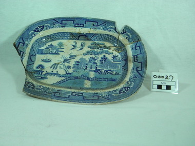
Plate
Found at Allen's Flat on the Buckland Goldfield, site of Allen and Farleys Store which was traded during the 1850s through to the 1860s. Site of reported violence during the Buckland Riot in 1857.Artifact from an area that reportedly had a population of 5,000 during the goldrush of 1850s but now virtually a deserted and overgrown valley. oval, blue and white willow ware design, crockerymakers stamp on back, crown above sash with letters, J ? ? ?, behive underneath, partly surrounded by a laurel ? wreath. Numeral 3 adjacent to the makers stampkitchen ware, flat, crockery, willow ware, buckland, allens -
 Hume City Civic Collection
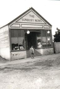
Photograph, Early 1900s
The Sunbury Newsagency and Sunbury News building was originally sited in Brook Street on the site of the present newsagency from 1900 to 1910. It was then moved over to Evans Street, next to the Post Office.A black and white photograph of the weatherboard Sunbury News building. A man with his back to the camera is outside the building and a bicycle is against the front of the building.sunbury news, boardman, eric, arthur, george evans collection -
 Victorian Aboriginal Corporation for Languages
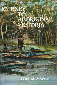
Book, Aldo Massola, Journey to Aboriginal Victoria, 1969
Looks at the Aboriginal community from the time of white contact, across many parts of Victoria. Chap.1; Melbourne - early missions, camp of Native Police, corroboree trees, canoe trees, grave &? headstone of Derrimut; quarries at Keilor, excavation sites at Green Gully &? Keilor; quarry at Mt. William, notes on inheritance of quarries Coranderrk settlement - Barraks grave, notes on his life; Chap.2; Geelong - Yawangi group of the Wothowurong tribe, camping grounds in area quarries; Notes on William Buckley, Gellibrand (a notable Aboriginal), graves in the Western Cemetery; Chap.3; Colac - war between Colac &? Geelong tribes; Mission at Birregurra, reason for failure of Buntingdale Mission; brass plate to Coc-coc-coine; reserve at Elliminyt, native ovens, camp sites, initiation site &? ritual; quarry sites, axegrinding factory, rock pecking &? engraving; dried hand &? 3 Aboriginal skulls found; Chap.4; The south-west coast - middens, camp sites notes on Framlingham Stn., fish traps at Tyrendarra; Chap.5; The far west - massacres of Aborigines near Casterton; camp sites, oven mounds; the first cricket team formed; Aboriginal cemetery; Chap.6; Hamilton - camps; Mount Rouse Station, axegrinding grooves at Nareeb Nareeb, shelters described, fish traps, massacre at Lake Condah; mission; canoes; Chap.7; Camperdown - legend about Lake Bullen Merri; obelisk erected in memory of Aborigines of district especially chief Wombeetch Puyuun; Jarcoort tribe; fish weirs, camps, intertribal fights between Booluc-burrers, Jarcoorts &? Ellengermote groups; bartering place at Mount Noorat; articles traded, legend of Flat-Top Hill; Chap.8; Ballarat - camp at Lake Wendouree; White Stone Lagoon; legends concerning Mt. Buninyong &? waterfalls at Lal-lal; camp sites; pygmy-type implements near Meredith, quarry at Glue Pot Rocks near Durdidwarrah; brass plate of King Billy; Chap.9; Ararat - Tjapwurong territory; camp sites, quarries, shield &? canoe trees; Bunyip belief at Lake Buninjon of Muk-jarawaint &? Pirtkopen-noot tribes, gives legend; stone implements; mill stones; fish weirs; stone arrangement near Lake Wongan; ground drawing of a bunyip, paintings in rock shelter near Mt. Langi Ghiran; Chap.10; Maryborough - camps, oven mounds, rock wells, stone arrangement at Carisbrook; camp sites at Mt. Franklin; Chap.11; Charlton - belief in Mindye (snake); canoe trees, ovens, camp sites, water holes, rock wells, stone implements; method of rainmaking; Chap.12; Horsham-Stawell, The Wimmera - Wotjobaluk land; camps, fish traps at Toolondo; Black Range cave paintings, Flat Rock shelters (detailed account of these paintings); Bunjils Cave; Chap.13; Horsham-Stawell, The Mallee - camp sites, implements; Ebenezer Mission, Willie Wimmera taken to England by Rev. Chase to become a missionary, died in England; Chap.14; The Murray River, Mildura Swan Hill - Battle of the Rufus; ceremonial ground, Lake Gol Gol, canoe &? shield trees; stone implements; camp sites, fire place arrangements; fish traps; oven mounds; Chap.15; The Murray River, Swan Hill-Echuca - legend about Lake Boga; camps, oven mounds, the Cohuna skull, Kow Swamp, method of burial; Chap.16; Shepparton ovens; brass plates of King Paddy of Kotupna &? King Tattambo of Mulka Stn., native well, camps; Chap.17; Wangaratta -camps, quarry, rock holes, the Faithful massacre; grinding rocks at Earlston; Chap.18; The High Plains - Ya-itma-thang; camps, Bogong moth feasts, native paths for trade &? intertribal fights, articles traded; painted shelters; Koetong Ck. Valley, near Mt. Pilot &? near Barwidgee Ck.; Chap.19; Dandenong - water holes, list of 8 holes in Beaumaris - Black Rock area; camps, middens, stone implements (microliths), legend of Angels Cave, stone axes, Native Police Force, Narre Narre Warren Station, legend about rocks on Bald Hill, kangaroo totemic site; Chap.20; Wonthaggi- Yarram - natives visit Phillip Is., murder of William Cook and Yankee by five Tasmanians (listed as Bon Small Boy, Jack Napoleon Timninaparewa, Fanny Waterpoordeyer, Matilda Nattopolenimma and Truganini) near Cape Patterson, men; camp sites, middens, legend of White Rock; Chap.21; Sale - Bairnsdale, The Lakes Country middens, camps; legend at Wulrunjeri; story of a white woman supposedly living with with the Tutangolung tribe, efforts made to prove story; canoe trees; Chap.22; Sale-Bairnsdale, The Inland Braiakolung tribe, camps, implements, canoe &? shield trees; Ramahyuck Mission, grinding rocks, fights with Omeo tribe; native tracks, death through enemy magic - procedure, belief in ghosts; Chap.23; Lakes Entrance and the Country to the east - Kroatungolung people, legend of Kalimna Valley; camps, stones of Nargun, bunyip, devils at Lake Tyers, excavation at Buchan, carbon dates; middens, ochre at Cape Conrad, stone fish-hook file at Thurra River; note on Bidwel tribe; Each chapter gives historical details, early contacts, relationships with settlers; Aboriginal place names and detailed description of sites and geographical features.b&w photographs, b&w illustrations, colour illustrationsgeelong, colac, hamilton, camperdown, ballarat, ararat, maryborough, charlton, horsham, stawell, murray river, shepparton, wangaratta, dandenong, wonthaggi, yarram, sale, bairnsdale, lakes entrance -
Glenelg Shire Council Cultural Collection
Photograph - Photograph - Sheet of contact prints showing silo and conveyor construction, 1964
Port of Portland Authority ArchivesFront: 83. 23.9.64 84. 23-9-64 85. 23-9-64 95. 23-9-64 96. 23-9-64 86. 23-9-64 (In white, beneath each print).port of portland -
 Ringwood and District Historical Society
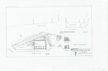
Plan, Drill Hall Site - Design for Military Units and Miniature Rifle Range, Ringwood, Victoria - Circa 1935
Technical drawings (a) Block Plan - Ringwood Drill Hall Site, Station Street, Ringwood. (b) Plan View, End and Side Elevation, Drill Hall Wodonga - Removed to Ringwood. (c) Plan View, Front and Rear Elevations, Minature Rifle Range at Ringwood Drill Hall.Commonwealth of Australia. Department of The Interior, Works & Services Branch, Victoria. -
Bendigo Historical Society Inc.
Book - TOURING SACRED MINE SIGHTS OF BENDIGO, 1994
16 page booklet 'Touring Sacred Mine Sights of Bendigo' Produced by Bendigo Mining and the Victorian Chamber of Mines.1994. Researched and written by David Horsfall and printed by Bendigo Modern Press. Details and suggested walking and driving tours of old mine sites. Includes 3 maps.David G Horsfall -
 Bendigo Historical Society Inc.
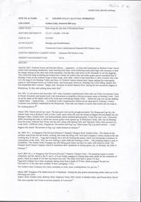
Document - GOLDEN GULLY ALLUVIAL WORKINGS
Golden Gully alluvial workings, Diamond Hill area, site number 1.1. Document has map/grid references, parcel number and location - runs along Woodward Road. History from 1851 to 186 detailed. . Information from David Bannear's Bendigo goldfields survey. -
 Bendigo Historical Society Inc.
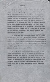
Document - CENTRAL DEBORAH GOLD MINE - HISTORY OF CENTRAL DEBORAH GOLD MINE 1939 - 1954
4 typed pages of the history of the Central Deborah Gold Mine from 1939 to 1954. Mentions the start of mining at this site and Victor Pabst, who in 1917 recommended that the shaft be deepened. His advice was not acted on for another twenty-two years. Also mentioned is the geology and Method of Mining.mine, gold, central deborah gold mine, central deborah gold mine, history of central deborah gold mine, geology of the central deborah gold mine, method of mining -
 Maffra Sugarbeet Museum
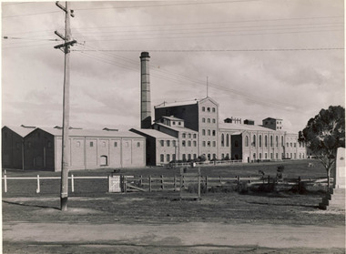
Photograph
The WWI war memorial has since been moved to the front of the RSL Rooms/Maffra Memorial Hall. It is now in front of the Library.A first generation black and white photographic print of the Maffra Sugarbeet Factory in more recent years. It shows the front of the factory from the road, with a fence and some telephone lines and the World War I memorial in the photograph. The sugar store, which is still on site, appears to the nearer end.world war 1914-1918, sugarbeet -
 National Vietnam Veterans Museum (NVVM)
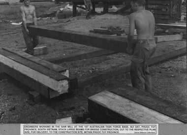
Photograph, Saw Mill 1
A black and white photograph of Engineers working in the saw mill at 1st Australian Task Force, Nui Dat, Phuoc Tuy Province, South Vietnam stack large beams for bridge construction, cut to the respective plan size for delivery to the construction site within Phuoc Tuy Province.photograph, engineers, 1 atf base, nui dat, phuoc tuy province, gibbons collection catalogue -
Whitehorse Historical Society Inc.
Article, People before profit - land sale opponent, 1992
A community group has criticised Nunawading Council's move to rezone and sell the Vermont South site it uses.A community group has criticised Nunawading Council's move to rezone and sell the Vermont South site it uses. The land is on the corner of Burwood Highway and Livingstone Road which is zoned D 'Public Open Space'. Council has deferred the decision to rezone until after a public meeting.A community group has criticised Nunawading Council's move to rezone and sell the Vermont South site it uses.town planning, city of nunawading, burwood highway, vermont south, livingstone road, vermont south, vermont south -
Whitehorse Historical Society Inc.
Document, Monier Wunderlich Tile Factory, 1989-96
Papers concerning sub-division of the former Monier-Wunderlich Tile Factory site.Papers concerning sub-division of the former Monier-Wunderlich Tile Factory site between Rooks and Mitcham Roads Vermont. Includes City of Nunawading planning documents and correspondence with residents; Wunderlich Residents' Action Group circulars; correspondence and drafts by W & B Gray relating to the proposals.Papers concerning sub-division of the former Monier-Wunderlich Tile Factory site. wunderlich limited, monier-redlands pty ltd, mitcham road, mitcham, rooks road, vermont, nos. 147-157, wunderlich residents' action group, rosstrevor crescent, mitcham, redlands properties, gray, william, gray, beryl -
 Whitehorse Historical Society Inc.
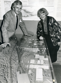
Photograph, Cr. Valda Arrowsmith & L. Fell, C.1987-88
Black and white photo of Cr. Valda Arrowsmith, Mayor of City of Nunawading 1987-88, with Les Fell, C.E.O. of City of Nunawading with Model of Proposed Railway Development. State Government Proposal for West of Springvale Road, Nunawading. Defeated after Council & Community objections as unsuitable site.arrowsmith, valda, fell, les -
 Ballarat Tramway Museum
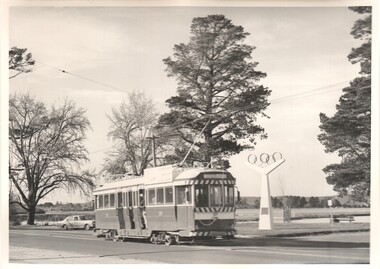
Photograph - Black & White Photograph/s, Charles Craig, 1971
Yields information about the appearance of the Olympic Monument in Wendouree Parade, Lake Wendouree and the trams that passed by. Black and White photograph of tram of 39 passing the site of the Olympic rings in Wendouree Parade, near Hamilton Ave. Tram has the destination of Gardens via Sturt St West. Shows the lake and the parklands at the time. Photo by Charles Craig - during 1971. Two copies held. trams, tramways, wendouree parade, olympics, lake wendouree, tram 39 -
Canterbury History Group
Ephemera - 8 McGregor Street Canterbury, 2001
Real estate advertisement for the sale by auction of "Ashford" 8 McGregor Street Canterbury, on Saturday 1 September 2001. Includes coloured photographs of the Interior and exterior of the house and floor and site plans. A note on the flyer by Robin Kelly indicates that the property was passed in at $670, 000 and sold later.canterbury, mcgregor street, ashford, edwardian style, maling road -
Canterbury History Group
Ephemera - Prime redevelopement site 250-252 Canterbury Road Surrey Hills, 2004
Real estate advertisement for the sale by auction of two shops at 250-252 Canterbury Road Surrey Hills, on Wednesday 10 March 2004. Includes coloured photographs of front and back of the building, site plan and letter from the agents, Gormankelly, reporting the sale of the property for $800, 000.surrey hills, canterbury road, shops, golden mile canterbury