Showing 22512 items
matching copying
-
 Greensborough Historical Society
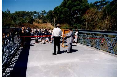
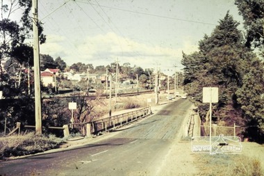
Photograph - Digital Image, Anne Paul, Opening of restored Old Lower Plenty Bridge 2001, 14/03/2001
The opening of the restored Old Lower Plenty Bridge, opened on 14/03/2001 by the Minister for Environment and Conservation Sherryl Garbutt MLA and Mayor of Banyule Cr Dale Peters. The project was jointly funded by Banyule Council and Parks Victoria. The restored bridge is the oldest remaining bridge in the former Shire of Eltham and forms part of the Plenty River Trail.Digital copy of colour photographlower plenty, lower plenty bridge, sherryl garbutt, dale peters, banyule council, parks victoria -
 Greensborough Historical Society
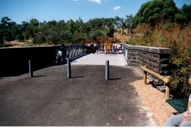
Photograph - Digital Image, Anne Paul, Opening of restored Old Lower Plenty Bridge 2001 - area adjacent, 14/03/2001
The opening of the restored Old Lower Plenty Bridge, opened on 14/03/2001 by the Minister for Environment and Conservation Sherryl Garbutt MLA and Mayor of Banyule Cr Dale Peters. The project was jointly funded by Banyule Council and Parks Victoria. The restored bridge is the oldest remaining bridge in Nillumbik and forms part of the Plenty River Trail. this photograph shows the area adjacent to the bridge on the day of the opening.Digital copy of colour photographlower plenty, lower plenty bridge, sherryl garbutt, dale peters, banyule council, parks victoria -
 Greensborough Historical Society
Photograph - Digital Image, Anne Paul, Opening of restored Old Lower Plenty Bridge 2001 - bridge and community, 14/03/2001
The opening of the restored Old Lower Plenty Bridge, opened on 14/03/2001 by the Minister for Environment and Conservation Sherryl Garbutt MLA and Mayor of Banyule Cr Dale Peters. The project was jointly funded by Banyule Council and Parks Victoria. The restored bridge is the oldest remaining bridge in the former Shire of Eltham and forms part of the Plenty River Trail. This photograph shows the bridge area ready for the opening ceremony and the assembled community members attending the function.Digital copy of colour photographlower plenty, lower plenty bridge, sherryl garbutt, dale peters, banyule council, parks victoria -
 Greensborough Historical Society
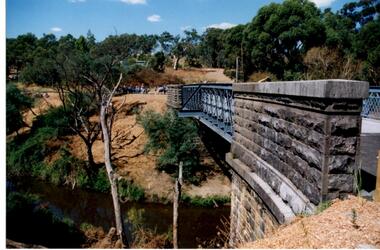
Photograph - Digital Image, Anne Paul, Opening of restored Old Lower Plenty Bridge 2001 - side view of bridge, 14/03/2001
The opening of the restored Old Lower Plenty Bridge, opened on 14/03/2001 by the Minister for Environment and Conservation Sherryl Garbutt MLA and Mayor of Banyule Cr Dale Peters. The project was jointly funded by Banyule Council and Parks Victoria. The restored bridge is the oldest remaining bridge in the former Shire of Eltham and forms part of the Plenty River Trail. This photograph shows the bridge from the side elevation, showing the bluestone and iron construction.Digital copy of colour photographlower plenty, lower plenty bridge, sherryl garbutt, dale peters, banyule council, parks victoria -
 Greensborough Historical Society
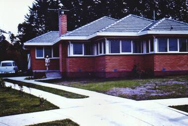
Photograph - Digital Image, 25 McKellar Street Watsonia 1966, 1966_
25 McKellar Street Watsonia 1966. Built 1965.Digital copy of colour photographmckellar street watsonia -
 Greensborough Historical Society
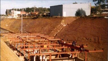
Photograph - Digital Image, Watsonia Railway Station 1975, 1975_
Watsonia rail line being moved below road level mid 1970s. This photograph shows work on the cutting and beginning of station. Watsonia Station was opened in 1977 when the rail line was lowered to remove level crossings and duplicate the line between Macleod and Greensborough.Digital copy of colour photographwatsonia station, hurstbridge rail line -
 Greensborough Historical Society
Photograph - Digital Image, Building Watsonia Station 1975, 1975_
Building Watsonia Station circa 1975. This photograph shows the framework for the new station being installed. The new Watsonia Station was opened in 1977 when the rail line was lowered to remove level crossings and duplicate the line between Macleod and Greensborough.Digital copy of colour photographwatsonia station, hurstbridge rail line -
 Greensborough Historical Society
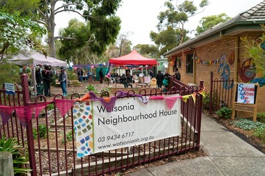
Photograph - Digital Image, Marilyn Smith, Watsonia Neighbourhood House, 15/06/2019
Watsonia Neighbourhood House, 47 Lambourn Road Watsonia. Provides adult education classes and workshops, as well as social and mutual-support activities. This photogrsph was taken at the Sustainable Watsonia Open Day 2019.Digital copy of colour photographwatsonia neighbourhood house, lambourn road watsonia, neighbourhood houses -
 Greensborough Historical Society
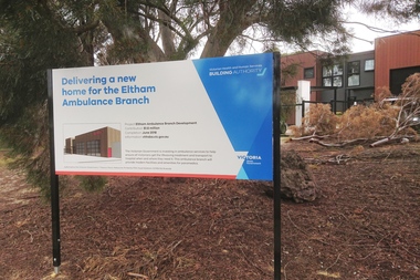
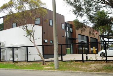
Photograph - Digital Image, Eltham Ambulance Branch - sign, 2018, 1930s
Eltham Ambulance Branch, Apex Way Montmorency. The original ambulance station on this site was opened in 1975 and demolished in 2017. This photograph shows the sign with the new ambulance station, opened in 2018, in the background.Digital copy of colour photographeltham ambulance station, ambulance victoria, apex way montmorency -
 Greensborough Historical Society
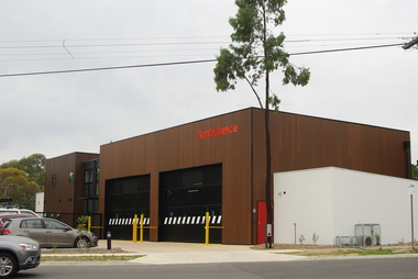
Photograph - Digital Image, Eltham Ambulance Branch from Looker Road, 2018, 1930s
Eltham Ambulance Branch, Apex Way Montmorency. The original ambulance station on this site was opened in 1975 and demolished in 2017. This photograph shows the new ambulance station, opened in 2018, from Looker Road.Digital copy of colour photographeltham ambulance station, ambulance victoria, apex way montmorency, looker road montmorency -
 Greensborough Historical Society
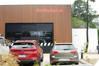
Photograph - Digital Image, Marilyn Smith, Eltham Ambulance Branch from Apex Way, 2018, 03/12/2018
Eltham Ambulance Branch, Apex Way Montmorency. The original ambulance station on this site was opened in 1975 and demolished in 2017. This photograph shows the new ambulance station, opened in 2018, from the front in Apex Way.Digital copy of colour photographeltham ambulance station, ambulance victoria, apex way montmorency -
 Greensborough Historical Society
Photograph - Digital Image, Marilyn Smith, Eltham Ambulance Branch from Grand Boulevard, 2018, 03/12/2018
Eltham Ambulance Branch, Apex Way Montmorency. The original ambulance station on this site was opened in 1975 and demolished in 2017. This photograph shows the new ambulance station, opened in 2018, from the front Grand Boulevard.Digital copy of colour photographeltham ambulance station, ambulance victoria, apex way montmorency, grand boulevard montmorency -
 Greensborough Historical Society
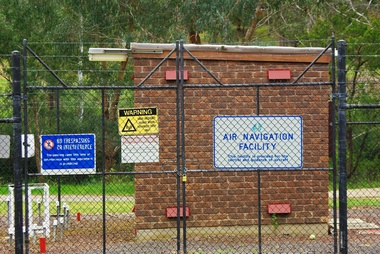
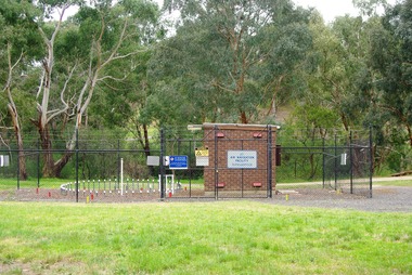
Photograph - Digital Image, Air Navigation Facility, Montmorency, 2018, 1930s
Air Navigation Facility, Palara Court Montmorency, is made up of a tower and brick building surrounded by wire fences. It is sited in parkland at the end of Palara Court close to the Plenty River Trail. Warning signs are placed on the fences, including: "This facility is provided for the control and guidance of aircraft".Digital copy of colour photographair navigation facility, air control, palara court montmorency -
 Greensborough Historical Society
Photograph - Digital Image, Marilyn Smith, Air Navigation Facility, Montmorency, 2018. Long view, 04/12/2018
Air Navigation Facility, Palara Court Montmorency, is made up of a tower and brick building surrounded by wire fences. It is sited in parkland at the end of Palara Court close to the Plenty River Trail. Warning signs are placed on the fences, including: "This facility is provided for the control and guidance of aircraft".Digital copy of colour photographsair navigation facility, air control, palara court montmorency -
 Greensborough Historical Society
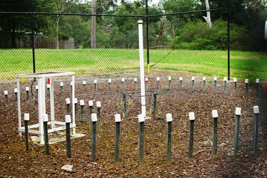
Photograph - Digital Image, Marilyn Smith, Air Navigation Facility, Montmorency, 2018. Close up, 04/12/2018
Air Navigation Facility, Palara Court Montmorency, is made up of a tower and brick building surrounded by wire fences. It is sited in parkland at the end of Palara Court close to the Plenty River Trail. Warning signs are placed on the fences, including: "This facility is provided for the control and guidance of aircraft".Digital copy of colour photographair navigation facility, air control, palara court montmorency -
 Greensborough Historical Society
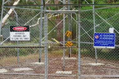
Photograph - Digital Image, Marilyn Smith, Air Navigation Facility, Montmorency, 2018. Signs at tower, 04/12/2018
Air Navigation Facility, Palara Court Montmorency, is made up of a tower and brick building surrounded by wire fences. It is sited in parkland at the end of Palara Court close to the Plenty River Trail. Warning signs are placed on the fences, including: "This facility is provided for the control and guidance of aircraft". This photograph shows signs at tower.Digital copy of colour photographair navigation facility, air control, palara court montmorency -
 Greensborough Historical Society
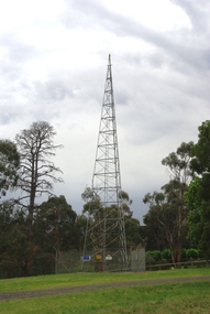
Photograph - Digital Image, Marilyn Smith, Air Navigation Facility, Montmorency, 2018. Tower, 04/12/2018
Air Navigation Facility, Palara Court Montmorency, is made up of a tower and brick building surrounded by wire fences. It is sited in parkland at the end of Palara Court close to the Plenty River Trail. Warning signs are placed on the fences, including: "This facility is provided for the control and guidance of aircraft". This photograph shows the tower on the site.Digital copy of colour photographsair navigation facility, air control, palara court montmorency -
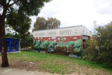 Greensborough Historical Society
Photograph - Digital Image, Marilyn Smith, Watsonia Timber Supply 2018, 04/12/2018
Watsonia Timber Supply, 58 Watsonia Road Watsonia. This business now trades as Rex Paine Timber and Hardware. This photograph show the mural on the side wall of the building.Digital copy of colour photographwatsonia shopping centre, rex paine timber and hardware, watsonia road watsonia, murals, watsonia timber supply -
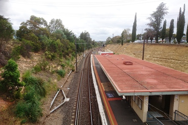 Greensborough Historical Society
Photograph - Digital Image, Marilyn Smith, Watsonia Station - looking toward Greensborough, 04/12/2018
Watsonia Station - looking up the rail line toward Greensborough, showing old trees above the cutting.Digital copy of colour photographwatsonia station, hurstbridge rail line -
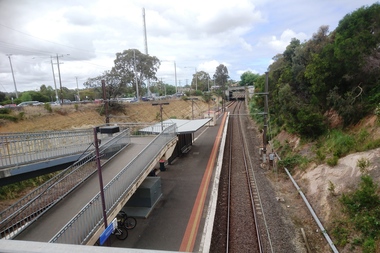 Greensborough Historical Society
Photograph - Digital Image, Marilyn Smith, Watsonia Station - looking toward city, 04/12/2018
Watsonia Station - looking down the rail line toward the city of Melbourne.Digital copy of colour photographwatsonia station, hurstbridge rail line -
 Greensborough Historical Society
Match Container - Digital Image, Harrick Dry Cleaners, 1980s
Advertisement on a matchbook for Harrick Dry Cleaners of Main Street Greensborough 1980sPart of a collection of miscellaneous advertisements for businesses in Greensborough and surrounding areas.Digital copy of matchbook advertisement.main street greensborough, harrick dry cleaners -
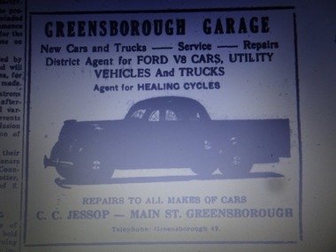 Greensborough Historical Society
Advertisement - Digital Image, Greensborough Garage 1940s, 1940s
Advertisement from a newspaper for Greensborough Garage of Main Street Greensborough 1940s. Proprietor: C.C. Jessop (known as Snowy Jessop).Part of a collection of miscellaneous advertisements for businesses in Greensborough and surrounding areas.Digital copy of newspaper advertisement.main street greensborough, greensborough garage, snowy jessop, clarrie jessop, jessop family -
 Greensborough Historical Society
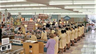
Photograph - Digital Image, Coles New World Greensborough, late 1960s, 1960s
Colour photograph of Coles New World interior with staff at every checkout. It appears to be taken soon after the supermarket was opened (see banner in centre of photo "New World Opening". This store was located in Main Street Greensborough. Digital copy of colour photographcoles new world greensborough, main street greensborough, supermarket -
 Greensborough Historical Society
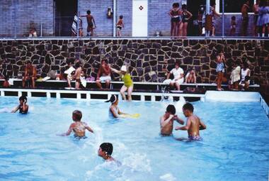
Photograph - Digital Image, Greensborough Pool, 1970s, 1970s
Photograph of Greensborough swimming pool in the 1970s. Digital copy of colour photographgreensborough pool, greensborough swimming pool -
 Greensborough Historical Society
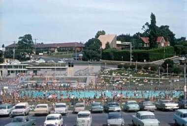
Photograph - Digital Image, Greensborough Pool carpark, 1970s, 1970s
Photograph of Greensborough swimming pool in the 1970s with carpark in foreground. This photograph shows the popularity of the local pool. Digital copy of colour photographgreensborough pool, greensborough swimming pool -
 Greensborough Historical Society
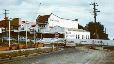
Photograph - Photograph - Digital Image, Main Street bridge Greensborough 1970s, 1970s
A colour photograph of the corner of Para Road and Main Street Greensborough in the 1970s, during the duplication and construction of the bridge over the Plenty River.Digital copy of colour photograph.main street greensborough, para road greensborough, plenty river bridge -
 Greensborough Historical Society
Photograph - Photograph - Digital Image, Para Road bridge 1960s, 1960s
A photograph of the Para Road bridge 1960s, with rail line running parallel. Digital copy of colour photograph.para road greensborough, para road bridge -
 Mission to Seafarers Victoria
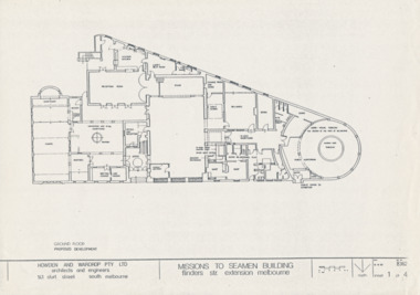
Drawing - Architectural drawings, Howden & Wardrop Pty Ltd, Mission to Seamen Building, 1983
3 of the 4 plans by Howden and Wardrop Pty Ltd part of their 1983 report for renovations. They were made from the T. Howes and P. Demetrios plans which were their submission for the Mathew Flinders Measured Drawing Competition as mentioned in the report.A4 copies of original planshowden and wardrop pty ltd, 1983, vhr 1496, t. howes, p.demetrios -
 Greensborough Historical Society
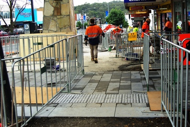
Photograph - Digital Image, Marilyn Smith, Main Street Greensborough, installation of new footpath, 24/06/2018
Installation of new footpath on Plaza side of Main Street GreensboroughDigital copy of colour photographmain street greensborough -
 Greensborough Historical Society
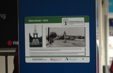
Photograph - Digital Image, Main Street Plaques: Main Street 1923, 18/06/2018
Historical Plaques in the Greensborough shopping strip. The view of Main Street Greensborough in 1923. This photograph was taken from near the current (2019) site of the Plaza entrance in Main Street. Further information available on GHS website.The Main Street Plaques Project was undertaken by Greensborough Historical Society and made possible with a grant from the Greensborough RSL.Digital copy colour photographmain street greensborough, main street plaques project