Showing 23714 items
matching creeks
-
 Eltham District Historical Society Inc
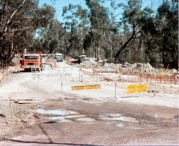
Photograph, Widening of Main Road Bridge over Diamond Creek, Eltham, c.1984, 1984c
Four colour photographs showing road works for widening of the Main Road bridge over Diamond Creek; two showing Main Road south of Mt Pleasant Road and one from the corner of Antoinette Blvd, Eltham, Vic.eltham, main road, diamond creek, main road bridge, bridges, construction -
 Eltham District Historical Society Inc
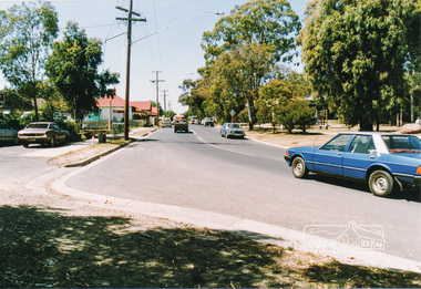
Photograph, Heidelberg-Kinglake Road, Hurstbridge; looking north east towards Kinglake
Two colour photographs taken near the location of the present roundabout intersection of Anzac Road (on right) and Arthurs Creek Road (on left) with the Heidelberg-Kinglake Road at Hurstbridge. [37�38'14.8"S 145�11'39.6"E -37.637459, 145.194322]main street, kinglake road, heidelberg/kinglake road, hurstbridge -
 Bendigo Historical Society Inc.
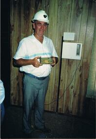
Photograph - AUSTIN COLLECTION: RAY BEER, GAFFNEYS CREEK
Colour photos : 2 photos, same image of Ray Beer, holding a gold ingot. Ray dressed in hard hat, casual clothing. Written on photo ' Ray Beer with 201 ozs of gold A.1. Mine, Gaffneys Creek'bendigo, mining, gaffneys creek -
 Bendigo Historical Society Inc.
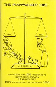
Book - STRAUCH COLLECTION: THE PENNYWEIGHT KIDS
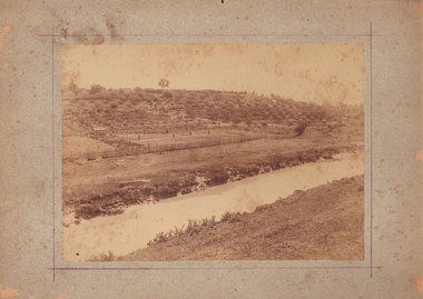
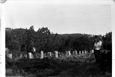
The Pennyweight Kids 1852 1857, why did more than 200 children die at Forest Creek, Victoria and who were they ? 1830 The Ancestors - The Descendants 1930, soft cover 116 pages with black and white photographs & illustrations.A R McMillanplace, cemetery, castlemaine, history-victoria-castlemaine-children-cemetery -
 Bendigo Historical Society Inc.
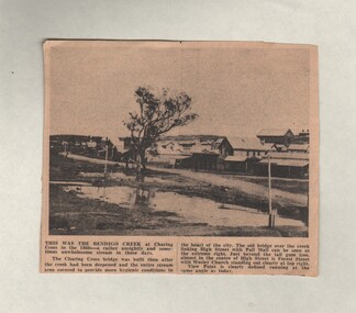
Document - BASIL MILLER COLLECTION: TRAMS - BENDIGO CREEK AT CHARING CROSS
Newspaper clipping, date unknown, with photograph taken in the 1860's. Shows old bridge over creek linking High Street and Pall Mall. Indicates location of Forest Street, and shows Wesley Church to the in centre left background.person, individual, basil miller -
 Bendigo Historical Society Inc.
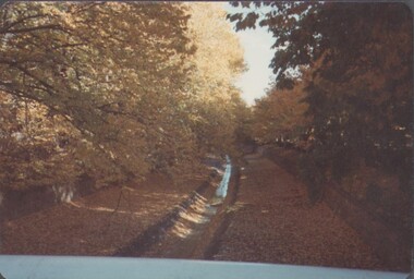
Photograph - EDITH LUNN COLLECTION: ROSILAND PARK, 27/07/1995
Rosiland park in Autumn 1982 10A Rosiland Park, looking up the Bendigo Creek 1982 10B Rosiland Park, Autumn 12/05/1991 10C work on restoration of the Cascades, Rosiland Park 22/10/1996Edith Lunn -
 Bendigo Historical Society Inc.
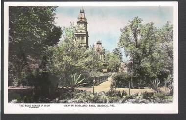
Postcard - ROSALIND PARK, BENDIGO
Colour postcard: image shows Post Office clock viewed from Rosalind Park, Bendigo. Walkway over creek in centre, post office clock on LH side. On rear in pencil' keep to show how attractive it used to be 'The Rose Series P 10429bendigo, parks and gardens, rosalind park, bendigo, rosalind park, post office -
 Bendigo Historical Society Inc.
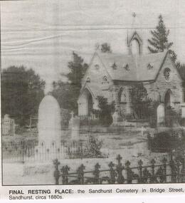
Newspaper - JENNY FOLEY COLLECTION: FINAL RESTING PLACE
Bendigo Advertiser "The way we were" from 1999. Final resting place: the Sandhurst cemetery in Bridge Street, Sandhurst, circa 1880s. NOTE: Photo incorrectly labelled. This chapel is at the Back Creek Cemetery in Carpenter Street Bendigo.newspaper, bendigo advertiser, the way we were -
 Clunes Museum
Photograph, ROGER PURCELL, SEBASTAPOL GARDENS, 1994 [COPY]
ORIGINAL PHOTOGRAPH OWNED BY MR. WILLIAM HARRIS OF SUTHERLAND STREET CLUNES..1 ORIGINAL PHOTOGRAPH OF PEOPLE WORKING IN THE GARDEN ON THE OTHER SIDE OF THE CREEK.. THE PHOTOGRAPH IS GLUED ON TO LIGHT BROWN CARDBOARD .2 - .4 COPIES OF POINT 1 .5 A COPY OF THE ORIGINAL (.1) PHOTOGRAPH GLUED ONTO CREAM CARDBOARDW H HARRIS LAND CIRCA 1870 -1880 WINNERS OF PICKLES AND JAMS COMPETITION IN INDIA 1886 harris family, sebastapol gardens, w h harris, pickles and jams competition -
 Lakes Entrance Regional Historical Society (operating as Lakes Entrance History Centre & Museum)
Postcard, Valentine Series, 1940
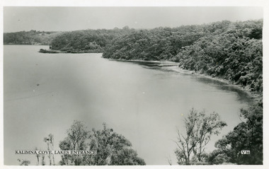
Black and white postcard taken from elevation on Jemmys Point, showing Reeves Channel, Gippsland Lakes, including Kalimna Jetty and Sawmill Flat at entrance to Maringa Creek, timbered cliffs above lake. Lakes Entrance VictoriaKalimna at Lakes Entrancetourism, boats and boating, jetties, waterways -
 Southern Sherbrooke Historical Society Inc.
Photograph - Bagging potatoes on Hermon farm, Menzies Creek
Series of black and white photos showing workers bagging potatoes and loading onto trucks. These were taken on the Hermon farm on Black Hill Road, Menzies Creek. The Hermon family leased this land from the State Forest Commission. -
 Southern Sherbrooke Historical Society Inc.
Photograph - Catherine Currie nee Madigan
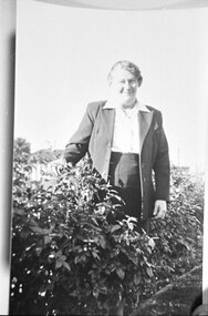
Photo shows a middle-aged woman standing near a low hedge. She is wearing a suit and an open-necked blouse and she is smiling. She is Catherine Currie nee Madigan, daughter of Patrick and Margaret Madigan of Menzies Creek.. -
 Bendigo Historical Society Inc.
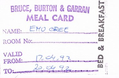
Document - PETER ELLIS COLLECTION: MEAL CARD, 17th - 20th, 1992
Small white coloured card. Purple stamped writing, black stamped Bed & Breakfast Handwritten Blue pen. Bruce, Burton and Garran Meal Card Name: Emu Creek (sic) Room No: Valid From: 17.04.92 To: 20.04.92person, individual, peter ellis oam -
 Bendigo Historical Society Inc.
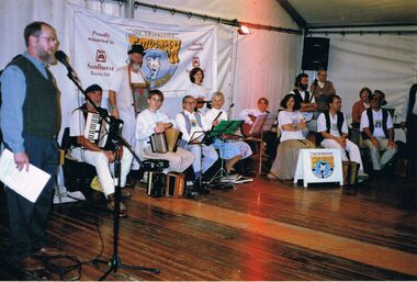
Photograph - PETER ELLIS COLLECTION: ROB WILLIS CD LAUNCH
Colour photo of a group of musicians and one man at a microphone. Banner behind the band has Emu Creek Bush Band and Sandhurst Trustees Ltd printed on it. Written on the back: CD launch by Rob Willis at the Canberra Folk Festival.photo, group, emu creek bush band, peter ellis collection, rob willis, emu creek bush band, sandhurst trustees ltd -
 Bendigo Historical Society Inc.
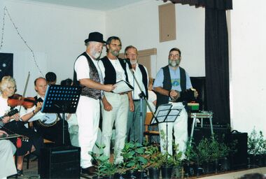
Photograph - PETER ELLIS COLLECTION: BUSH BAND
Colour photo. Band on stage in hall. 4 men standing. Violin. Concertina. Back of photo reads: Emu Creek Goornong Aust. Day Concert. Singers John Williams Stan Symes Wayne Blandford Peter Ellis.photo, group, musicians -
 Bendigo Historical Society Inc.
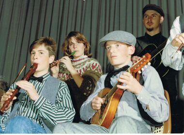
Photograph - PETER ELLIS COLLECTION: BAND
Colour photograph. Younger band members. Boy on wooden recorder, young woman playing tin whistle, younger boy on lute and older boy with guitar. Back of photo reads: Emu Creek Junior Band. 13 13.photo, group, musicians -
 Bendigo Historical Society Inc.
Photograph - PETER ELLIS COLLECTION: BAND PLAYING
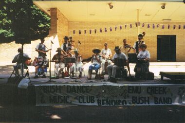
Colour photograph. Band on stage outside. Banner reading 'The Bush Dance & Music Club of Bendigo with the Emu Creek Bush Band'. Australia flag bunting. Back of photo reads: 7A Sound Shell Rosalind Park Bendigo.entertainment, music, musicians -
 Bendigo Historical Society Inc.
Photograph - PETER ELLIS COLLECTION: EMU CREEK BUSH BAND
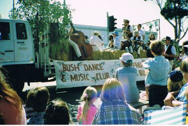
Colour photograph. Bush Band on tray of small truck with hay bales. The Bush Dance and Music Club of Bendigo. Emu Creek Bush Band. Crowd watching. Back of photo reads: Bendigo Easter Fair 1990'sentertainment, music, bush dance and music club -
 Bendigo Historical Society Inc.
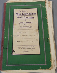
Administrative record - Work program
BHS CollectionA set of thirty-seven drawing of mainly of animals done by children. The sketches are in a green folder called the revised new curriculum work programme for rural schools 1943, school no. 2396, name McKenzie Creek, Teache Maya McKebery.mckenzie creek, drawing -
 Kew Historical Society Inc
Photograph - Flooding of the Yarra Valley at Kew East, 1974
Flooding of the Yarra Valley, including that section of the Yarra bordering Kew and Kew East in the north and west of the municipality, was a regular occurrence. Extreme flood events of the Yarra River are recorded to have occurred in 1891, 1901, 1916, 1923 and 1934. The Municipality of Kew's response to these floods was to enact planning decisions restricting residential development in flood prone areas following the floods of 1916, 1921 and 1934. While floods continued after the development of the Upper Yarra Reservoir (construction 1948-57), the regularity and extent of these inundations diminished. During the nineteenth century, the land abutting the south side of the Yarra in Kew was devoted to dairy farming. In the twentieth century, before and after the construction of the Eastern Freeway, much of this low-lying area was used as golf courses and public parks.Late example of the capacity of the Yarra Valley at Kew to flood, even though drainage works and the Upper Yarra Reservoir had reduced their regularity.Original black and white print photograph of the low-lying land at East Kew under floodwater on 16 May 1974. The vantage point of the photographer is Lister Street. Flooding was caused by overflowing water in Glass' Creek and the River Yarra. Annotation verso: "Lister Street looking north / Flood level / 16 May 1974 11.30am / R.L. 46.04"hays paddock, floods, yarra river, glass' creek, lister street -
 Kew Historical Society Inc
Photograph - Flooding of the Yarra Valley at Kew East, 1974
Flooding of the Yarra Valley, including that section of the Yarra bordering Kew and Kew East in the north and west of the municipality, was a regular occurrence. Extreme flood events of the Yarra River are recorded to have occurred in 1891, 1901, 1916, 1923 and 1934. The Municipality of Kew's response to these floods was to enact planning decisions restricting residential development in flood prone areas following the floods of 1916, 1921 and 1934. While floods continued after the development of the Upper Yarra Reservoir (construction 1948-57), the regularity and extent of these inundations diminished. During the nineteenth century, the land abutting the south side of the Yarra in Kew was devoted to dairy farming. In the twentieth century, before and after the construction of the Eastern Freeway, much of this low-lying area was used as golf courses and public parks.Late example of the capacity of the Yarra Valley at Kew to flood, even though drainage works and the Upper Yarra Reservoir had reduced their regularity.Original black and white print photograph of the low-lying land at East Kew under floodwater on 16 May 1974. The vantage point of the photographer is Lister Street. Flooding was caused by overflowing water in Glass' Creek and the River Yarra. Annotation verso: "Lister St looking same as No.3 / 16 May 1974 11.30"floods, yarra river, glass' creek, lister street -
 Federation University Art Collection
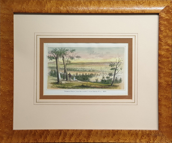
Work on paper - Printmaking - Lithograph, Gill, Samuel Thomas, Creswick Creek (Near Ballarat) from Spring Hill, 1887
In 1887 Creswick had a population of around 25,000 people during the gold rush but now is only about 1/10th of its original size. This item is part of the Federation University Art Collection. The Art Collection features over 2000 works and was listed as a 'Ballarat Treasure' in 2007.Framed hand coloured lithographic print from Wither's 'History of Ballarat' showing two diggers looking over Creswick Creek. A scar tree is depicted in the left foreground. The work was published in the 1887 History of Ballarat by W.B. Withers. art, artwork, creswick, samuel thomas gill, s.t. gill, f.w. niven, available, lithograph, printmaking, scar tree, near ballarat, spring hill, scarred tree -
 Tarnagulla History Archive
Research file: District Schools, District Schools, 1869 to 1960s
Donald Clark Collection A red binder containing research compiled about the history of schools in Tarnagulla and district. Lists of names including School Committee members, teachers and students. Schools in Tarnagulla, Murphy's Creek, Arnold West, Arnold, Maidentown (Llanelly) and Laanecoorie. tarnagulla, murphy's creek, arnold west, arnold, maidentown, llanelly, laanecoorie -
 Bendigo Historical Society Inc.
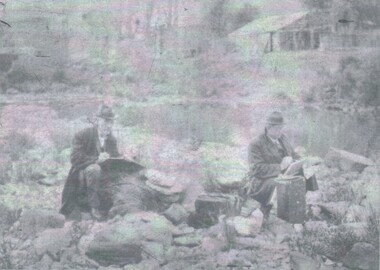
Photograph - PORTRAIT - SHIRLOW AND HUDSPETH
Negative Photograph of John SHIRLOW and John HUDSPETH, both drawing, sitting on the bank of a creek/water way, behind the men high up on the bank, a brick building and looks like a timber shed. On computer check SHIRLOW was a artist.Bartlett Bros. Bendigo.photograph, portrait, john shirlow. john hudspeth. -
 Falls Creek Historical Society
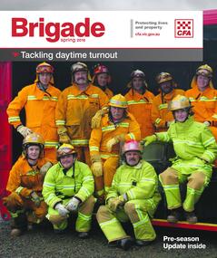
Magazine - Brigade Magazine Spring 2016
Brigade Magazine is issued to members of the Victorian CFA. The Spring edition of 2016 includes an article to acknowledge 21 years of service by the Falls Creek CFA. The article was written by Joy Nowakowski on behalf of the Falls Creek CFA with information provided by the Falls Creek Historical Society. Falls Creek Fire Brigade protects Falls Creek Village from fires throughout the year and supports other brigades to fight bushfires nearby and further away. In 2016 the brigade had 23 year-round volunteers. At a celebratory function at Falls Creek in June 2016, alpine pumper and brigade snowmobiles were on display. Falls Creek’s alpine pumper was the first of its kind in Australia. It had a pumping capacity of 4,000 litres a minute and its tracks enabled it to access areas of the village and ski fields. Until 2016 Falls Creek Village has been threatened by two major fires, the worst being in 2003 when CFA crews saved the village and the adjoining ski field infrastructure right at the boundaries. Snow making equipment was used to create a water/fog barrier that helped stop the fires from taking the village. The team that saved the village was considered heroic Support for fighting fires at Falls Creek dates back to 1956 but this support came from Mount Beauty, 30 kilometres down the mountain. Falls Creek locals were concerned by this, so used six available hydrants and a canvas hose to fight any fires on the mountain. In 1964 the SECV gave the village a trailer which could be used with both wheels and skis for summer and winter operations. But this trailer only lasted two years. In the early 1970s, the village was given a 2,000-gallon Ford Blitz 4WD truck, and additional equipment was quickly acquired by the village including a new locally-constructed trailer with a pumper unit. In the 1990s, a change in land status meant the Falls Creek area became the responsibility of CFA. This status was formalised in 1995 by a public meeting that formed Falls Creek Fire Brigade.This magazine is significant because it contains an article celebrating 21 years of Falls Creek CFA.A publication for CFA members which includes stories about recent incidents, brigades, training, events, community safety, health and safety and general CFA news. falls creek cfa, alpine firefighting, falls creek cfa 21 years -
 Orbost & District Historical Society
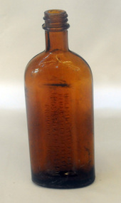
bottle, first half 20th century
In 1852 Bosisto opened Australia’s first commercial eucalyptus oil distillery, at Dandenong Creek in Victoria, followed by others at Emerald, Menzies Creek and Macclesfield. and began selling the oil locally. Eucalyptus oil was used as a liniment. Bosisto's bottles were generally used for eucalyptus oil. the eucalyptus oil industry was a significant early Victorian industry. Bosisto's products were commoly used in households of the first half of the 20th century. A flat-sided, brown, glass bottle with a threaded top. It has rounded shoulders.in rectangle on back - THIS BOTTLE IS AND ALWAYS REMAINS THE PROPERTY OF J. BOSISTO & COMPANTY LTD on base - F1196 M and 239 vertically -
 Greensborough Historical Society
Article, John Daniels: following the footsteps of Batman, by Jan Hanslow, 11/07/2014
Discussion of John Daniels' theory that "Batman's Treaty" was signed on the southern bank of the Merri Creek in Reservoir. It follows Batman up the Maribyrnong River and his meeting with 'a native family' who took him to the Merri Creek.1 p. reprint of address at general Meeting [of Port Phillip Pioneers Group?] 11 July 2014, by Jan Hanslowbatmans treaty, john daniels, john batman, merri creek -
 Victorian Interpretive Projects Inc.
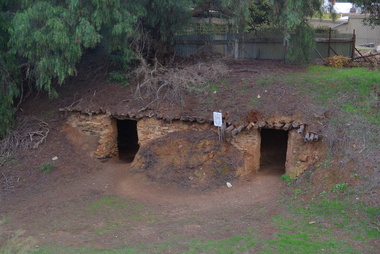
Photograph - colour, Clare Gervasoni, Dugouts, Burra, South Australia, 29/05/2013
In 1847 dugout homes along the Burra Creek extended for along 5 kilometres. The census of 1851 recorded a population of 4,403 for the town, with 1,800 living in hunts in 'Creek Street'. The dug outs were rent free.Photograph of dugout accommodation in Blyth Street, Burra. -
 Stawell Historical Society Inc
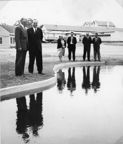
Photograph, Matron Hamilton & others Inspecting the Toddler’s Pool at the Stawell Special School 1967
Inspecting Toddler’s Pool at Special School Stawell 1967 Special School Stawell Former Pleasant Creek Hospital site. Sometimes referred to as Pleasant Creek Special School and sometimes Pleasant Creet Training Centre.stawell education -
 Hume City Civic Collection
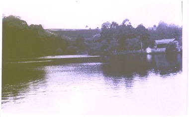
Photograph, The Nook, c1940
The Nook in Sunbury is situated on a wide and deep bend in Jacksons Creek. Today the area is a popular site for passive recreation with a walking path along the Jacksons Creek. The house on the RHS of the photograph was situated near Powlett Street.Before the Aquatic Centre was built in Sunbury the swimming pool at The Nook was the town's swimming pool for many years. Seats and a change area were at the site.A black and white photograph of a large bend in a river with a house built on its riverbank and another dwelling on the hillside in the middle distance.the nook, swimming, jacksons creek