Showing 10989 items matching "land "
-
 Bendigo Historical Society Inc.
Document - ABBOTT COLLECTION: MEMORABILIA
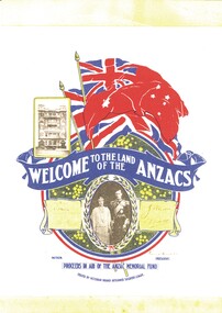
Found inside the Abbott family Bible, a small leaflet titled 'Welcome to the land of the Anzacs' in aid of the Anzac Memorial Fund. Issued by Victorian Branch Returned Soldiers League.societies, order of .., returned soldiers league -
 Bendigo Historical Society Inc.
Document - GLENYS MCKITTERICK COLLECTION: WILLIAM BEEBE DOCUMENTS, 19th June, 1917
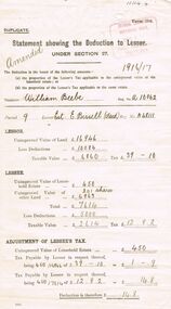
Buff coloured document, flimsy. Statement showing the deduction to Lessee. Issued to William Beebe, A/10062, Estate of E. Bissell ( Decd), A48111. UCV of land 16,946 pounds.person, bendigo, william beebe -
 Bendigo Historical Society Inc.
Document - BUSH COLLECTION: TAX AND RATE NOTICES, 1920 - 1930
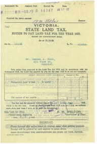
Collection of approximately 24 tax and rate notices pertaining to S. A. Bush. Includes State income tax and Land Tax, Federal Income Tax, City of Bendigo rates.person, individual, bush collection - personal -
 Bendigo Historical Society Inc.
Book - IN A PICTURE LAND OVER THE SEA, c1998
In a Picture land over the sea. Publisher: Author and Bendigo Art Gallery. Printed by: Print Creations, Bendigo. ISBN:0949215163. 76 pages. Photographs, illustrations some in colour.Karen Quilanart, lifestyle, portrait -
 Bendigo Historical Society Inc.
Document - PLANS FROM LAND OFFICE , BENDIGO
Royal Historical Society of Victoria Bendigo and district branch. Plans from Land office, Bendigo. Four pages listing of parishes and two pages listing of Township plans. -
 Port Melbourne Historical & Preservation Society
Archive - File, Ewan Ogilvy's Bayside Papers, Box Two: Bayside Press Cuttings, 1987
Ewan OGILVY, former Melbourne Councillor and also of Community Services Victoria, Inner Urban Ministerial Advisory Committee and Uniting Church's Centre for Urban Research and Action (CURA), was instrumental in social justice approaches to town planning. He and CURA's Social Justice and the City Project funded Port Melbourne community groups protesting against the SCDC development in 1987. His files were presented to the Society in May 2001 on his preparation for leaving Victoria.From Ewan OGILVY's chronologically organised 'Bayside Papers' relating to the proposed development of Port Melbourne industrial land in the late 1980s, bound file: 'Bayside' press cuttingsAll items signed 'Ewan Ogilvy'town planning, town planning - proposals shelved - bayside, public action campaigns, environmental issues, public housing, missions to seamen, centre for urban research and action, sandridge city development co pty ltd, scdc, linton r lethlean, ewan ogilvy, barry pullen -
 Bendigo Historical Society Inc.
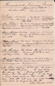
Document - CONNELLY, TATCHELL, DUNLOP COLLECTION: DOCUMENTS FOR KOONDROOK TRAIN
Documents and letters from Connelly and Tatchell solicitors, Sandhurst and Kerang, regarding costs and land transfers for the Koondrook train or tramway. There are 29 documents dated from 1888 to 1889.organization, public utility, transport -
 Bendigo Historical Society Inc.
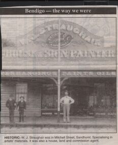
Newspaper - JENNY FOLEY COLLECTION: HISTORIC
Bendigo Advertiser "The way we were" from 1999. Historic: W.J. Straughair was in Mitchell Street, Sandhurst. Specialising in artists' materials, it was also a house, land and commission agent.newspaper, bendigo advertiser, the way we were -
 Bendigo Historical Society Inc.
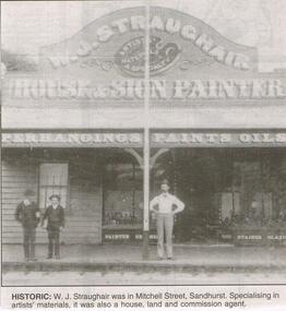
Newspaper - JENNY FOLEY COLLECTION: HISTORIC
Bendigo Advertiser "The way we were" from 1999. Historic: W.J. Straughair was in Mitchell Street, Sandhurst. Specialising in artists materials, it was also a house, land and commission agent.newspaper, bendigo advertiser, the way we were -
 National Vietnam Veterans Museum (NVVM)
Photograph, Various Weapons
Framed coloured photo of what appears to be captured weapons including a rocket launcher, serveral rockets and land mines. civilian men, women and children can be seen in the background.photograph, weapons -
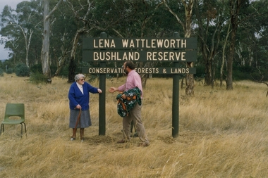 Clunes Museum
Photograph
A CORNER BLOCK OF BUSHLAND NAMED LENA WATTLEWORTH BUSHLAND RESERVE.COLOUR PHOTOGRAPH LENA WATTLEWORTH BUSHLAND RESERVE CONSERVATION FORESTS AND LAND. PHOTO TAKEN TALBOT ROAD. MRS WATTLEWORTH DURING THE PRESENTATION. PHOTGRAPH MOUNTED ON WHITE CARDBOARD.local history, photography, photographs, weickhardt, wattleworth -
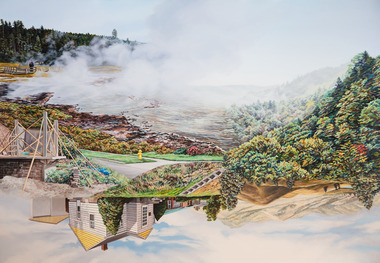 Nillumbik Shire Council
Painting: Kevin CHIN, Kevin Chin, Castle Under the Sky, 2018
This painting was sparked by a US studio residency at Yellowstone National Park, shortly after Trump’s election. In America, Chin witnessed conservative nationalism and divisiveness, but also an equal reaction promoting diversity and challenging structural inequality. Developing this work in Australia, Chin examined how a sense of place forms fluidly in the consciousness, to surpass geographic borderlines.Kevin Chin is a local artist. He has been a finalist in the Nillumbik Prize for Contemporary Art (2015, 2019). In this painting Chin explores economic, cultural and social structures that shape the world in which we live, questioning who has built what, who takes ownership, and who has the right to the land. Landscape painting depicting a house (upside down) and a half finished urban structure sitting amongst mountain peaks and land that has been cleared and immersed in fog/smoke.N/Alandscape, kevin, chin, structural, inequality, castle, trump, painting, nillumbik, residency, yellowstone, realism, oils -
Whitehorse Historical Society Inc.
Document, Notes on history of the Taintons of East Burwood, n.d
Notes by Ken Smith, descendant of the Tainton Family. James and Ann Tainton arrived in Australia in 1853, bought land between Hawthorn and Burwood Roads near Blackburn Road.tainton family, tainton, james, tainton, ann, tainton road, burwood east -
Whitehorse Historical Society Inc.
Map, Cadastral Map System, 2005
Land Victoria map of section of Blackburn North.Land Victoria map of section of Blackburn North, inc. Middleborough Road, Joseph Street and Chapman Street. Scale: 1:1500. With Lot Nos. and block frontage dimensions.Land Victoria map of section of Blackburn North. middleborough road, blackburn north, joseph street, blackburn north, chapman street, blackburn north -
Whitehorse Historical Society Inc.
Newspaper - Article, Death notice of John Allan Matheson, 2/02/1995
Notice of death and memorial service for John Allan Matheson, younger son of Captain Charles and Mary Matheson. Matheson land bought by City of Nunawading for the bi-centennial orchard.matheson, john allan -
 Whitehorse Historical Society Inc.
Document - Extract of Land Conveyance, Patrick Riley, 9/5/1870
Photocopy of extract of Memorial Book of conveyance dated 9/5/1870 for sale of land in the Parish of Nunawading. Sold by James Coyne Riley to Patrick Riley. 3 pages.land sales;, riley, patrick, james coyne -
 Whitehorse Historical Society Inc.
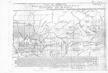
Map, Plan of locality, 1855-60?
'Plan of locality, showing the whole line of route to the district from Melbourne by way of Nunawading and Bulleen. 2,000 acres for sale... Thomas Ham, Land Agent [ 1855 - 60?]nunawading, bulleen, barkers track, land sales -
 Whitehorse Historical Society Inc.
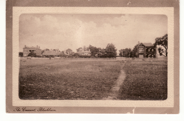
Postcard - Black and white postcard, The Crescent Blackburn (Now Gordon Crescent)
Sepia postcard entitled 'The Crescent, Blackburn'.ow Gordon Crescent, Blackburn. Picture shows Victorian and Edwardian homes.|Probably these homes were part of the land boom of the 1890s.hooke, janet emily, albert arthur, the crescent, blackburn, gordon crescent -
 Bendigo Historical Society Inc.
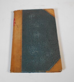
Administrative record - Report of sales by auction 1877-1898
Book with greenish/blueish cover, brown leather spine and corners. The book covers land sales by auction for the years 1877 to 1898. The sales are listed under Town and County.On the spine red label with gold letters: "Reports of sales by auction" also on the spine in red texter the number 7, in black the letter E and 1877 to 1898land sales, auctions, 1877-1898 -
Canterbury History Group
Document - Canterbury Bowling Club - Agreement, 1935
Agreement between The Mayor, Councillors and Citizens of the City of Camberwell and Messrs A.G. Greenham and A .McK. Hislop, trustees of the Canterbury Bowling Club, 1935. Includes map of land to be occupied.canterbury bowling club, kendall street, city of camberwell, scott street, canterbury gardens, greenham> arthur george, hislop> arthur mckenzie, maps, canterbury -
Lakes Entrance Historical Society
Book, Calder Stuart and Winty, East Cunninghame and Lake Tyers Beach. A case study Report, 1976
A case history of resort development in the Lake Tyers Beach Victoria coast area, considering the history of land use and future planning with regard to environmental impact and social requirements.natural history, land settlement -
 Lakes Entrance Historical Society
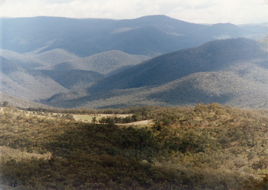
Photograph - Suggan Buggan, Tambo Shire, 1994 c
Also second identical copyColour photograph of the scenery in Suggan Buggan, showing very heavily forested mountainous country, a small area of cleared land centre left foreground. Suggan Buggan Victoriasettlement, agriculture, topography -
 Bacchus Marsh & District Historical Society
Map, Maddingley Township, Parish of Parwan, County of Grant, 1856
Maddingley is a locality or township within the broader township area of Bacchus Marsh. This map is dated 1856 but is based on an earlier survey in 1843. The main area of Maddingley shown on this map is an area bounded by Bacchus Street, Moore Street, Griffith Street and Franklin Street. Other streets visible are Inglis Street, Labilliere Street, McCrae Street. The area to the east of Franklin Street is not sub-divided and is described as an 'alluvial flat. A single page paper map showing land allotments, streets, and natural watercourses in the township of Maddingley. The map is pasted into a bound volume containing 76 maps or plans in total. Two inscriptions: 1. A.J. Skene Surveyor, 1843. ; 2. Surveyor-General's Office Melbourne, Sept 6, 1856. (Lithographed by R. Meikle)bacchus marsh victoria maps, maddingley victoria maps, land use, maddingley victoria history -
 Bendigo Historical Society Inc.
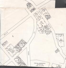
Map - VICTORIA HILL - MAP - HAPPY VALLEY RD - DARE ST
Small map showing some blocks of land in the Happy Valley Road, Dare Street and Wells Streets area. Three of the blocks are in the name of Rae. Notes by Albert Richardson.map, bendigo, victoria hill, victoria hill, victoria hill - map - happy valley road - dare street, w rae, j rae -
Lakes Entrance Historical Society
Book, Paul Kelly & Associates, East Gippsland Shire Code of Practice July 2003, 2003
Code of practice detailing minimum acceptable standards of work on land managed , works includes construction works regular maintenance contractors and provision of services East Gippland Victoriavegetation, fire brigade -
 Bendigo Historical Society Inc.
Document - MARKS COLLECTION: HISTORY OF FORTUNA
Four pages typewritten history of Fortuna Villa from Mr. Ballerstedt purchasing the mine and land from the Wittscheibe Brothers to the subsequent sale to George Lansell and the various developments.place, fortuna, fortuna villa -
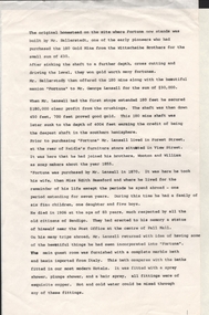
 Ringwood and District Historical Society
Map, The Ringwood Estate - Second Sub-Division, Ringwood, Victoria - 1919
Three cardboard-backed copies of map clipped from land sale auction brochure. Subdivision includes Warrandyte Road, Tamar Street, Mersey Street and Derwent Street.H.C. Crouch BCE, Licensed Surveyor, 443 LtCollins Street, Melbourne. Handwritten real estate notations in margins and on some allotments include sales information and reference LP7604 - Part of Crown Allotment 31B. Auction date June 14th, 1919. -
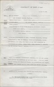 Bendigo Historical Society Inc.
Document - H. A. & S. R. WILKINSON COLLECTION: CONTRACT OF SALE
Contract of sale of land dated 4th August, 1951 between Mr. R. J. Eddy (vendor) and Mrs. E. R. Tieman (purchaser). Property: land being part of Crown allotment 18 section 54C Parish of Sandhurst City of Bendigo, land comprised in certificate of title volume 7150 folio 1429983 and situate No. 30 Gratten Street, Bendigo, together with 5 roomed weatherboard dwelling, all sundry outbuildings, also all linen roller blinds, all linos on floors, gas bath-heather, gas copper, electric sink heather and all wire doors and windows screens. Price: 2,425 pounds.organization, business, h.a. & s.r wilkinson real estate -
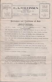 Bendigo Historical Society Inc.
Document - H. A. & S. R. WILKINSON COLLECTION: CONTRACT OF SALE
Conditions of sale by private contract dated 10th January, 1948 between Mrs. E. L. Gunn (vendor) and Mr. K. C. Turner (purchaser). Property: land situate No. 90 Ophir Street corner Rowan street, Bendigo, at present occupied by Mr. Sharp as tenant, being allotment 20 section 22S Parish of Sandhurst City of Bendigo land described in right to occupy residence area No. 4873, together with 6 roomed weatherboard dwelling, all sundry outbuildings on said land, except any of such outbuildings belonging to the tenant. Price: 450 pounds. Attached 3 hand written notes and 1 typed detailing repairs done to the property.organization, business, h.a. & s.r wilkinson real estate -
 Bendigo Historical Society Inc.
Photograph - The Wilkin Family of Sedgwick, 1800s-1900s
The Phil Wilkin Collection contains a series of 11 Items. The related items can be found by clicking on the reference link below. The following history of the Young family and their descendants who lived at the Springs is provided by Phil Wilkin. His Great Grandparents were Frances Young and August Wirth. Phil has also provided notes on the Wilkin Family and some history of the gold mining in Sedgwick. Frances Young's parents Joseph and Margaret Young owned the property called "The Old Place, Preston Vale or Wellington Flat" at Sedgwick near the Springs. Joseph Young owned and Managed the Standard Brewery which was located at Campbells Creek during the late 1800’s early 1900’s. Joseph and Margaret are buried in the Harcourt cemetery. In 1880 August Wirth lived at Mosquito Creek (Lake Eppalock, Victoria) when he married Frances Young. In 1902 they moved to part of Joseph Young's property. They milked cows and sold cattle for a living. One of their children Charles Wirth (Phil Wilkin's Grandfather) bought the land in 1935 after his parents had died. Charles Wirth was a councillor and also was president of the Shire of Strathfieldsaye. The "Old Place" was part of the property owned by members of the family. The old house at the Springs was burnt out by bushfire in January 1944 and much of the stonework was later vandalized by campers. The original Coliban Water Works were designed in 1863 by the Irish engineer Joseph Brady. The system included 70 kilometres of open water channels, aqueducts, syphons and tunnels to carry water (by gravity) from the Coliban River at Malmsbury, north to Castlemaine and Bendigo. Sedgwick is a locality in Central Victoria, Australia. It is located in the City of Greater Bendigo. Facilities include a public hall that opened in 1958 and CFA Rural fire station. It was named Upper Emu Creek until 1901 when it was renamed as Sedgwick after British geologist Adam Sedgwick.17 photos and historical document of the Wilkin Family associated with the Springs near Sedgwick. There are 182 photos in this series and can be found at 8683.1 to 8683.11. The series also includes photos of the surrounding farming land and the remains of an old house. There are also some notes on the pioneers of the district.history, bendigo, coliban water, joseph brady, irrigation, the springs, sedgwick, phil wilkin collection, standard brewery campbells creek, joeseph and margaret young, wilkin family