Showing 123959 items
matching main-road
-
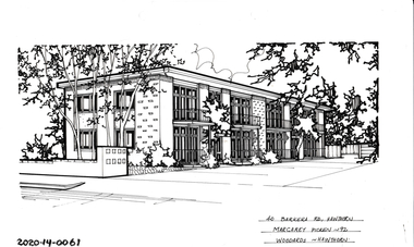 Hawthorn Historical Society
Drawing - Property Illustration, 40 Barkers Road, Hawthorn
'After training as a Cartographic Draftsman within the mining industry, I worked as a property illustrator for real estate firms in the eastern suburbs of Melbourne for 23 years from 1983. I initially photographed houses with a Polaroid camera and made a 'thumbnail' sketch while there. The photos were used to scale off a sketch in pencil and then that sketch was overlaid with drafting film and the 'pen and ink' completed. The pens I used were the Rotring ‘Rapidigraph’ drafting pens. The ink was also made by Rotring (German).The film was ‘Rapidraw’, polyester drafting film, double matte. It takes a very fine line and doesn’t bleed. As well as house sketches, there were often floor plans and site plans ordered. Aerial sketches were ordered when the property needed an overall view.' (Margaret Picken, 2020)This property illustration is one of a series created by Margaret Picken for a range of real estate agents in Melbourne between c. 1983 and c. 2006. Each work is signed and dated by the artist.Gift of Margaret Picken, 2020Pen and ink property illustration on drafting film of 40 Barkers Road, Hawthorn by Margaret Picken.40 Barkers Road, Hawthorn, Margaret Picken '92. Woodards - Hawthorn.artist - margaret picken 1950- -
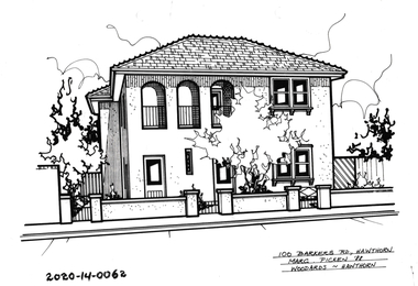 Hawthorn Historical Society
Drawing - Property Illustration, 100 Barkers Road, Hawthorn
'After training as a Cartographic Draftsman within the mining industry, I worked as a property illustrator for real estate firms in the eastern suburbs of Melbourne for 23 years from 1983. I initially photographed houses with a Polaroid camera and made a 'thumbnail' sketch while there. The photos were used to scale off a sketch in pencil and then that sketch was overlaid with drafting film and the 'pen and ink' completed. The pens I used were the Rotring ‘Rapidigraph’ drafting pens. The ink was also made by Rotring (German).The film was ‘Rapidraw’, polyester drafting film, double matte. It takes a very fine line and doesn’t bleed. As well as house sketches, there were often floor plans and site plans ordered. Aerial sketches were ordered when the property needed an overall view.' (Margaret Picken, 2020)This property illustration is one of a series created by Margaret Picken for a range of real estate agents in Melbourne between c. 1983 and c. 2006. Each work is signed and dated by the artist.Gift of Margaret Picken, 2020Pen and ink property illustration on drafting film of 100 Barkers Road, Hawthorn by Margaret Picken.100 Barkers Road, Hawthorn, Marg Picken '92. Woodards - Hawthorn.artist - margaret picken 1950- -
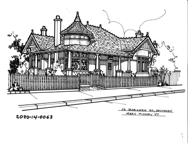 Hawthorn Historical Society
Drawing - Property Illustration, 116 Barkers Road, Hawthorn
'After training as a Cartographic Draftsman within the mining industry, I worked as a property illustrator for real estate firms in the eastern suburbs of Melbourne for 23 years from 1983. I initially photographed houses with a Polaroid camera and made a 'thumbnail' sketch while there. The photos were used to scale off a sketch in pencil and then that sketch was overlaid with drafting film and the 'pen and ink' completed. The pens I used were the Rotring ‘Rapidigraph’ drafting pens. The ink was also made by Rotring (German).The film was ‘Rapidraw’, polyester drafting film, double matte. It takes a very fine line and doesn’t bleed. As well as house sketches, there were often floor plans and site plans ordered. Aerial sketches were ordered when the property needed an overall view.' (Margaret Picken, 2020)This property illustration is one of a series created by Margaret Picken for a range of real estate agents in Melbourne between c. 1983 and c. 2006. Each work is signed and dated by the artist.Gift of Margaret Picken, 2020Pen and ink property illustration on drafting film of 116 Barkers Road, Hawthorn by Margaret Picken.116 Barkers Road, Hawthorn, Marg Picken '87. Woodards - Hawthorn.artist - margaret picken 1950- -
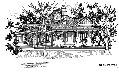 Hawthorn Historical Society
Drawing - Property Illustration, 340 Barkers Road, Hawthorn
'After training as a Cartographic Draftsman within the mining industry, I worked as a property illustrator for real estate firms in the eastern suburbs of Melbourne for 23 years from 1983. I initially photographed houses with a Polaroid camera and made a 'thumbnail' sketch while there. The photos were used to scale off a sketch in pencil and then that sketch was overlaid with drafting film and the 'pen and ink' completed. The pens I used were the Rotring ‘Rapidigraph’ drafting pens. The ink was also made by Rotring (German).The film was ‘Rapidraw’, polyester drafting film, double matte. It takes a very fine line and doesn’t bleed. As well as house sketches, there were often floor plans and site plans ordered. Aerial sketches were ordered when the property needed an overall view.' (Margaret Picken, 2020)This property illustration is one of a series created by Margaret Picken for a range of real estate agents in Melbourne between c. 1983 and c. 2006. Each work is signed and dated by the artist.Gift of Margaret Picken, 2020Pen and ink property illustration on drafting film of 340 Barkers Road, Hawthorn by Margaret Picken.340 Barkers Road, Hawthorn, Marg Picken '88. Woodards - C'well.artist - margaret picken 1950- -
 Hawthorn Historical Society
Drawing - Property Illustration, 344 Barkers Road, Hawthorn
'After training as a Cartographic Draftsman within the mining industry, I worked as a property illustrator for real estate firms in the eastern suburbs of Melbourne for 23 years from 1983. I initially photographed houses with a Polaroid camera and made a 'thumbnail' sketch while there. The photos were used to scale off a sketch in pencil and then that sketch was overlaid with drafting film and the 'pen and ink' completed. The pens I used were the Rotring ‘Rapidigraph’ drafting pens. The ink was also made by Rotring (German).The film was ‘Rapidraw’, polyester drafting film, double matte. It takes a very fine line and doesn’t bleed. As well as house sketches, there were often floor plans and site plans ordered. Aerial sketches were ordered when the property needed an overall view.' (Margaret Picken, 2020)This property illustration is one of a series created by Margaret Picken for a range of real estate agents in Melbourne between c. 1983 and c. 2006. Each work is signed and dated by the artist.Gift of Margaret Picken, 2020Pen and ink property illustration on drafting film of 344 Barkers Road, Hawthorn by Margaret Picken.344 Barkers Road, Hawthorn, Margaret Picken '95. Woodards - Hawthorn.artist - margaret picken 1950- -
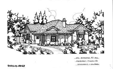 Hawthorn Historical Society
Drawing - Property Illustration, 450 Barkers Road, Hawthorn
'After training as a Cartographic Draftsman within the mining industry, I worked as a property illustrator for real estate firms in the eastern suburbs of Melbourne for 23 years from 1983. I initially photographed houses with a Polaroid camera and made a 'thumbnail' sketch while there. The photos were used to scale off a sketch in pencil and then that sketch was overlaid with drafting film and the 'pen and ink' completed. The pens I used were the Rotring ‘Rapidigraph’ drafting pens. The ink was also made by Rotring (German).The film was ‘Rapidraw’, polyester drafting film, double matte. It takes a very fine line and doesn’t bleed. As well as house sketches, there were often floor plans and site plans ordered. Aerial sketches were ordered when the property needed an overall view.' (Margaret Picken, 2020)This property illustration is one of a series created by Margaret Picken for a range of real estate agents in Melbourne between c. 1983 and c. 2006. Each work is signed and dated by the artist.Gift of Margaret Picken, 2020Pen and ink property illustration on drafting film of 450 Barkers Road, Hawthorn by Margaret Picken.450 Barkers Road, Haw, Margaret Picken '97. Woodards - Hawthorn.artist - margaret picken 1950- -
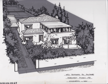 Hawthorn Historical Society
Drawing - Property Illustration, 456 Barkers Road, Hawthorn
'After training as a Cartographic Draftsman within the mining industry, I worked as a property illustrator for real estate firms in the eastern suburbs of Melbourne for 23 years from 1983. I initially photographed houses with a Polaroid camera and made a 'thumbnail' sketch while there. The photos were used to scale off a sketch in pencil and then that sketch was overlaid with drafting film and the 'pen and ink' completed. The pens I used were the Rotring ‘Rapidigraph’ drafting pens. The ink was also made by Rotring (German).The film was ‘Rapidraw’, polyester drafting film, double matte. It takes a very fine line and doesn’t bleed. As well as house sketches, there were often floor plans and site plans ordered. Aerial sketches were ordered when the property needed an overall view.' (Margaret Picken, 2020)This property illustration is one of a series created by Margaret Picken for a range of real estate agents in Melbourne between c. 1983 and c. 2006. Each work is signed and dated by the artist.Gift of Margaret Picken, 2020Pen and ink property illustration on drafting film of 456 Barkers Road, Hawthorn by Margaret Picken.456 Barkers Road, Hawthorn, Margaret Picken '93. Woodards - Hawthorn.artist - margaret picken 1950- -
 Hawthorn Historical Society
Drawing - Property Illustration, 534 Barkers Road, Hawthorn
'After training as a Cartographic Draftsman within the mining industry, I worked as a property illustrator for real estate firms in the eastern suburbs of Melbourne for 23 years from 1983. I initially photographed houses with a Polaroid camera and made a 'thumbnail' sketch while there. The photos were used to scale off a sketch in pencil and then that sketch was overlaid with drafting film and the 'pen and ink' completed. The pens I used were the Rotring ‘Rapidigraph’ drafting pens. The ink was also made by Rotring (German).The film was ‘Rapidraw’, polyester drafting film, double matte. It takes a very fine line and doesn’t bleed. As well as house sketches, there were often floor plans and site plans ordered. Aerial sketches were ordered when the property needed an overall view.' (Margaret Picken, 2020)This property illustration is one of a series created by Margaret Picken for a range of real estate agents in Melbourne between c. 1983 and c. 2006. Each work is signed and dated by the artist.Gift of Margaret Picken, 2020Pen and ink property illustration on drafting film of 534 Barkers Road, Hawthorn by Margaret Picken.534 Barkers Road, Haw, Margaret Picken '98. Woodards - Hawthorn.artist - margaret picken 1950- -
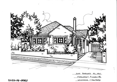
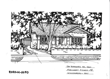
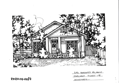
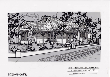 Hawthorn Historical Society
Drawing - Property Illustration, 544 Barkers Road, Hawthorn
'After training as a Cartographic Draftsman within the mining industry, I worked as a property illustrator for real estate firms in the eastern suburbs of Melbourne for 23 years from 1983. I initially photographed houses with a Polaroid camera and made a 'thumbnail' sketch while there. The photos were used to scale off a sketch in pencil and then that sketch was overlaid with drafting film and the 'pen and ink' completed. The pens I used were the Rotring ‘Rapidigraph’ drafting pens. The ink was also made by Rotring (German).The film was ‘Rapidraw’, polyester drafting film, double matte. It takes a very fine line and doesn’t bleed. As well as house sketches, there were often floor plans and site plans ordered. Aerial sketches were ordered when the property needed an overall view.' (Margaret Picken, 2020)This property illustration is one of a series created by Margaret Picken for a range of real estate agents in Melbourne between c. 1983 and c. 2006. Each work is signed and dated by the artist.Gift of Margaret Picken, 2020Pen and ink property illustration on drafting film of 544 Barkers Road, Hawthorn by Margaret Picken.544 Barkers Road, E Hawthorn, Margaret Picken '91. Woodards.artist - margaret picken 1950- -
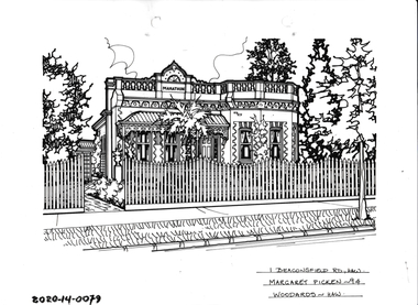 Hawthorn Historical Society
Drawing - Property Illustration, 1 Beaconsfield Road, Hawthorn
'After training as a Cartographic Draftsman within the mining industry, I worked as a property illustrator for real estate firms in the eastern suburbs of Melbourne for 23 years from 1983. I initially photographed houses with a Polaroid camera and made a 'thumbnail' sketch while there. The photos were used to scale off a sketch in pencil and then that sketch was overlaid with drafting film and the 'pen and ink' completed. The pens I used were the Rotring ‘Rapidigraph’ drafting pens. The ink was also made by Rotring (German).The film was ‘Rapidraw’, polyester drafting film, double matte. It takes a very fine line and doesn’t bleed. As well as house sketches, there were often floor plans and site plans ordered. Aerial sketches were ordered when the property needed an overall view.' (Margaret Picken, 2020)This property illustration is one of a series created by Margaret Picken for a range of real estate agents in Melbourne between c. 1983 and c. 2006. Each work is signed and dated by the artist.Gift of Margaret Picken, 2020Pen and ink property illustration on drafting film of 1 Beaconsfield Road, Hawthorn by Margaret Picken.1 Beaconsfield Road, Hawthorn, Margaret Picken '94. Woodards - Hawthorn.artist - margaret picken 1950- -
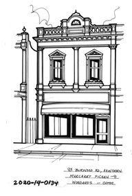 Hawthorn Historical Society
Drawing - Property Illustration, 93 Burwood Road, Hawthorn
'After training as a Cartographic Draftsman within the mining industry, I worked as a property illustrator for real estate firms in the eastern suburbs of Melbourne for 23 years from 1983. I initially photographed houses with a Polaroid camera and made a 'thumbnail' sketch while there. The photos were used to scale off a sketch in pencil and then that sketch was overlaid with drafting film and the 'pen and ink' completed. The pens I used were the Rotring ‘Rapidigraph’ drafting pens. The ink was also made by Rotring (German).The film was ‘Rapidraw’, polyester drafting film, double matte. It takes a very fine line and doesn’t bleed. As well as house sketches, there were often floor plans and site plans ordered. Aerial sketches were ordered when the property needed an overall view.' (Margaret Picken, 2020)This property illustration is one of a series created by Margaret Picken for a range of real estate agents in Melbourne between c. 1983 and c. 2006. Each work is signed and dated by the artist.Gift of Margaret Picken, 2020Pen and ink property illustration on drafting film of 93 Burwood Road, Hawthorn by Margaret Picken.93 Burwood Road, Hawthorn, Margaret Picken '91. Woodards - Comm.artist - margaret picken 1950- -
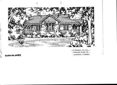 Hawthorn Historical Society
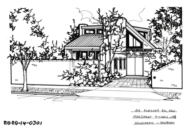
Drawing - Property Illustration, 3 Fordholm Road, Hawthorn
'After training as a Cartographic Draftsman within the mining industry, I worked as a property illustrator for real estate firms in the eastern suburbs of Melbourne for 23 years from 1983. I initially photographed houses with a Polaroid camera and made a 'thumbnail' sketch while there. The photos were used to scale off a sketch in pencil and then that sketch was overlaid with drafting film and the 'pen and ink' completed. The pens I used were the Rotring ‘Rapidigraph’ drafting pens. The ink was also made by Rotring (German).The film was ‘Rapidraw’, polyester drafting film, double matte. It takes a very fine line and doesn’t bleed. As well as house sketches, there were often floor plans and site plans ordered. Aerial sketches were ordered when the property needed an overall view.' (Margaret Picken, 2020)This property illustration is one of a series created by Margaret Picken for a range of real estate agents in Melbourne between c. 1983 and c. 2006. Each work is signed and dated by the artist.Gift of Margaret Picken, 2020Pen and ink property illustration on drafting film of 3 Fordholm Road, Hawthorn by Margaret Picken.3 Fordholm Road, Haw, Margaret Picken '96. Woodards - Hawthorn. artist - margaret picken 1950- -
 Hawthorn Historical Society
Drawing - Property Illustration, 44 Fordholm Road, Hawthorn
'After training as a Cartographic Draftsman within the mining industry, I worked as a property illustrator for real estate firms in the eastern suburbs of Melbourne for 23 years from 1983. I initially photographed houses with a Polaroid camera and made a 'thumbnail' sketch while there. The photos were used to scale off a sketch in pencil and then that sketch was overlaid with drafting film and the 'pen and ink' completed. The pens I used were the Rotring ‘Rapidigraph’ drafting pens. The ink was also made by Rotring (German).The film was ‘Rapidraw’, polyester drafting film, double matte. It takes a very fine line and doesn’t bleed. As well as house sketches, there were often floor plans and site plans ordered. Aerial sketches were ordered when the property needed an overall view.' (Margaret Picken, 2020)This property illustration is one of a series created by Margaret Picken for a range of real estate agents in Melbourne between c. 1983 and c. 2006. Each work is signed and dated by the artist.Gift of Margaret Picken, 2020Pen and ink property illustration on drafting film of 44 Fordholm Road, Hawthorn by Margaret Picken.44 Fordholm Road, Haw, Margaret Picken '99. Woodards - Hawthorn. artist - margaret picken 1950- -
 Hawthorn Historical Society
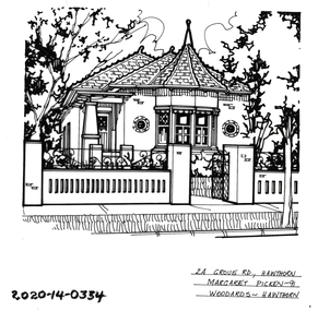
Drawing - Property Illustration, 2A Grove Road, Hawthorn
'After training as a Cartographic Draftsman within the mining industry, I worked as a property illustrator for real estate firms in the eastern suburbs of Melbourne for 23 years from 1983. I initially photographed houses with a Polaroid camera and made a 'thumbnail' sketch while there. The photos were used to scale off a sketch in pencil and then that sketch was overlaid with drafting film and the 'pen and ink' completed. The pens I used were the Rotring ‘Rapidigraph’ drafting pens. The ink was also made by Rotring (German).The film was ‘Rapidraw’, polyester drafting film, double matte. It takes a very fine line and doesn’t bleed. As well as house sketches, there were often floor plans and site plans ordered. Aerial sketches were ordered when the property needed an overall view.' (Margaret Picken, 2020)This property illustration is one of a series created by Margaret Picken for a range of real estate agents in Melbourne between c. 1983 and c. 2006. Each work is signed and dated by the artist.Gift of Margaret Picken, 2020Pen and ink property illustration on drafting film of 2A Grove Road, Hawthorn by Margaret Picken.2A Grove Road, Hawthorn, Margaret Picken '91. Woodards - Hawthorn. artist - margaret picken 1950- -
 Hawthorn Historical Society
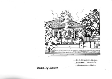
Drawing - Property Illustration, 21A Hambledon Road, Hawthorn
'After training as a Cartographic Draftsman within the mining industry, I worked as a property illustrator for real estate firms in the eastern suburbs of Melbourne for 23 years from 1983. I initially photographed houses with a Polaroid camera and made a 'thumbnail' sketch while there. The photos were used to scale off a sketch in pencil and then that sketch was overlaid with drafting film and the 'pen and ink' completed. The pens I used were the Rotring ‘Rapidigraph’ drafting pens. The ink was also made by Rotring (German).The film was ‘Rapidraw’, polyester drafting film, double matte. It takes a very fine line and doesn’t bleed. As well as house sketches, there were often floor plans and site plans ordered. Aerial sketches were ordered when the property needed an overall view.' (Margaret Picken, 2020)This property illustration is one of a series created by Margaret Picken for a range of real estate agents in Melbourne between c. 1983 and c. 2006. Each work is signed and dated by the artist.Gift of Margaret Picken, 2020Pen and ink property illustration on drafting film of 21A Hambledon Road, Hawthorn by Margaret Picken.21A HAMBLEDON ROAD, HAW Margaret Picken ~94 WOODARDS - HAWartist - margaret picken 1950- -
 Hawthorn Historical Society
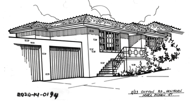
Drawing - Property Illustration, 2/ 23 Clifton Road, Hawthorn East
'After training as a Cartographic Draftsman within the mining industry, I worked as a property illustrator for real estate firms in the eastern suburbs of Melbourne for 23 years from 1983. I initially photographed houses with a Polaroid camera and made a 'thumbnail' sketch while there. The photos were used to scale off a sketch in pencil and then that sketch was overlaid with drafting film and the 'pen and ink' completed. The pens I used were the Rotring ‘Rapidigraph’ drafting pens. The ink was also made by Rotring (German).The film was ‘Rapidraw’, polyester drafting film, double matte. It takes a very fine line and doesn’t bleed. As well as house sketches, there were often floor plans and site plans ordered. Aerial sketches were ordered when the property needed an overall view.' (Margaret Picken, 2020)This property illustration is one of a series created by Margaret Picken for a range of real estate agents in Melbourne between c. 1983 and c. 2006. Each work is signed and dated by the artist.Gift of Margaret Picken, 2020Pen and ink property illustration on drafting film of 2/23 Clifton Road, Hawthorn East by Margaret Picken.2/23 Clifton Road, Hawthorn, Margaret Picken '87. artist - margaret picken 1950- -
 Glenelg Shire Council Cultural Collection
Photograph - Photograph - Main Breakwater construction, Portland, 29/08/1952
Port of Portland Authority ArchivesFront: MAIN BREAKWATER ACCESS ROAD 29/8/52 - black print Back: Purple PHT Stamp - print 4/7 Neg No. P1 Date taken 29.8.52 Subjectport of portland archives, main breakwater, construction, lady bay, portland, harbour -
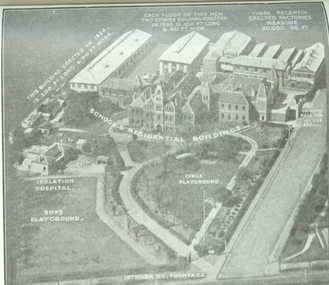 Vision Australia
Photograph - Image, Aerial view of the Royal Victorian Institute for the Blind grounds in St Kilda Road, 1927
Aerial photo of the RVIB St Kilda Road buildings and grounds, scanned from an unknown printed source. On the image are written descriptions of buildings, including the width and length of those erected in 1920's, the isolation hospital and the segregation of boys and girls playing areas. 1 scanned image of RVIB St Kilda Road from airGirls playground School & residential buildings Boys playground Isolation hospital This building, erected in 1926 - is 200 ft long & 40 ft wide Each floor of this new two storied building erected in 1926 is 100 ft long & 40 ft wide These recently erected factories measure 20,000 sq ft Ormond Hall for socials, etc. St Kilda Road frontageroyal victorian institute for the blind, buildings -
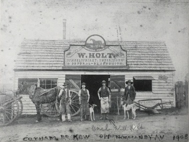 Kew Historical Society Inc
Photograph, Sandhill Forge, Cotham Road, c.1900
While a later inscription suggests that the photo dates from 1908, by that stage, according to the Sands & McDougall Directories, the forge on the corner of Cotham and Mont Victor Roads had been taken over by H. Wright. F.G.A. Barnard in his Jubilee History of Kew (1910) records that the well known Sandhill Nursery, had been established by William Holt early in the 1850s. Presumably this was an earlier business as by 1888 it is recorded that the business had become a forge. The forge stood on what is now part of the grounds of Genazzano Convent. A rare photograph of a pioneering industrial business in Kew on the site now occupied by Genazzano Convent.The photo shows W. Holt, Wheelwright, Veterinary and General - Blacksmith, Cotham Road, Kew. Inscription front: "Uncle Will Holt, Cotham Road, Kew, opp Normanby Av [sic] 1908 [sic]"; Reverse: "KHS February 1990. Gift of Mr Panther - Manager Westpac Bank, Kew. Given to Kew Historical Soc."sandhill forge, genazzano convent (kew), cotham road (kew), william holt -
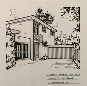 Kew Historical Society Inc
Drawing - Property Illustration, Margaret Picken, 130A Parkhill Road, Kew, 2002
After training as a Cartographic Draftsman within the mining industry, I worked as a property illustrator for real estate firms in the eastern suburbs of Melbourne for 22 years from 1983. I initially photographed houses with a Polaroid camera and made a 'thumbnail' sketch while there. The photos were used to scale off a sketch in pencil and then that sketch was overlaid with drafting film and the 'pen and ink' completed. The pens I used were the Rotring ‘Rapidigraph’ drafting pens. The ink was also made by Rotring (German).The film was ‘Rapidraw’, polyester drafting film, double matte. It takes a very fine line and doesn’t bleed. As well as house sketches, there were often floor plans and site plans ordered. Aerial sketches were ordered when the property needed an overall view. (Margaret Picken, 2020)This drawing is one of a series created by Margaret Picken for a number of real estate agents in Melbourne between 1983 and 2005. Each work is signed and dated by the artist.Gift of Margaret Picken, 2020Pen and ink architectural drawing on drafting film of 130A Park Hill Road, Kew by Margaret Picken.130A PARK HILL ROAD., KEW / PICKEN ©2002 / WOODARDSartist -- margaret picken 1950-, architectural drawings -- houses -- kew (vic.), 130a parkhill road -- kew (vic.) -
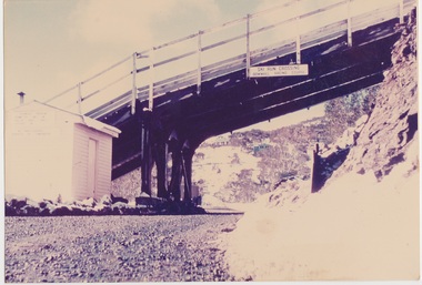 Falls Creek Historical Society
Photograph - Road Under Ski Run at Falls Creek, 1960
This ski run was built for the 1960 Australian Downhill Championships conducted at Falls Creek. It may have been built in conjunction with the SEC. This crossing was just below the Falls Creek Resort entrance. It had a vertical elevation of approximately 1,500 feet. The building pictured is a former SEC building which became the "Galleon" Ski Club and was later know as Cooroona. To the right is the Bowna Ski Club.This image is significant because it captures a structure created for the 1960 Australian Downhill Championships held at Falls Creek.Image of a road passing under a downhill ski run at Falls Creek. A building is visible on the left of the photo.On sign above road: SKI RUN CROSSING / DOWNHILL RACING COURSE1960 australian downhill championships, downhill ski run falls creek -
 Hawthorn Historical Society
Drawing - Property Illustration, 546 Barkers Road, Hawthorn East
'After training as a Cartographic Draftsman within the mining industry, I worked as a property illustrator for real estate firms in the eastern suburbs of Melbourne for 23 years from 1983. I initially photographed houses with a Polaroid camera and made a 'thumbnail' sketch while there. The photos were used to scale off a sketch in pencil and then that sketch was overlaid with drafting film and the 'pen and ink' completed. The pens I used were the Rotring ‘Rapidigraph’ drafting pens. The ink was also made by Rotring (German).The film was ‘Rapidraw’, polyester drafting film, double matte. It takes a very fine line and doesn’t bleed. As well as house sketches, there were often floor plans and site plans ordered. Aerial sketches were ordered when the property needed an overall view.' (Margaret Picken, 2020)This property illustration is one of a series created by Margaret Picken for a range of real estate agents in Melbourne between c. 1983 and c. 2006. Each work is signed and dated by the artist.Gift of Margaret Picken, 2020Pen and ink property illustration on drafting film of 546 Barkers Road, Hawthorn East by Margaret Picken.546 Barkers Road, Haw E, Margaret Picken '98. Woodards.artist - margaret picken 1950- -
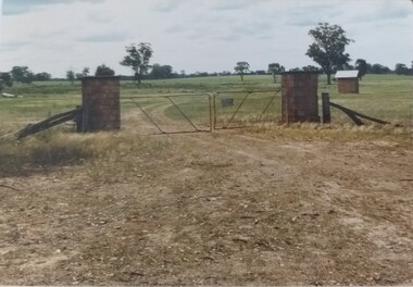 Tatura Irrigation & Wartime Camps Museum
Photograph, Camp 13 Main Entrance, 1989
Camp 13, Murchison, property owned by Jim Finnegan. German, Italian, Japanese prisoners held 1941-1946. Main entrance to Camp 13 Murchison.Camp 13 entrance gate, original stone pillars constructed using local stone, sentry box right mid -distance. Camp 13 Camp Road, Murchison. camp 13, pow, internment camps, murchison victoria, finnegan, japanese pows, german pows, italian pows -
Whitehorse Historical Society Inc.
Newspaper - Article, Mitcham Road, 8/09/1992
Advertisement for auction of 433 Mitcham Road, Mitcham, 12 September 1992.mitcham road, mitcham, no. 433, auctions -
Whitehorse Historical Society Inc.
Newspaper - Article, 10 Matheson Road, Forest Hill, 14/06/1995
Auction, 10 Matheson Road, Forest Hill, 24/06/1995matheson road, forest hill, matheson family, course family, auctions -
 Whitehorse Historical Society Inc.
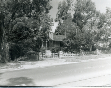
Photograph, No 5, Deep Creek Road, Mitcham, 1/09/2000 12:00:00 AM
Black and white photo of exterior of No 5 Deep Creek Road, Mitcham,mitcham, deep creek road -
 Whitehorse Historical Society Inc.
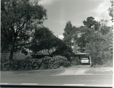
Photograph, 7 Deep Creek Road, Mitcham, 1/09/2000 12:00:00 AM
Black and white photo of exterior of 7 Deep Creek Road, Mitcham.mitcham -
 Whitehorse Historical Society Inc.
Photograph, 9 Deep Creek Road, Mitcham, 1/09/2000 12:00:00 AM
Black and white photo of exterior of 9 Deep Creek Road, Mitcham.mitcham -
 Whitehorse Historical Society Inc.
Photograph, 11 Deep Creek Road, Mitcham, 1/09/2000 12:00:00 AM
Black and white photo of exterior of 11 Deep Creek Road, Mitcham.mitcham -
 Whitehorse Historical Society Inc.
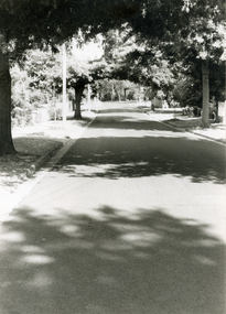
Photograph, Brunswick Road, Mitcham, 4/01/2001 12:00:00 AM
Black and white photograph looking west along Brunswick Road, Mitcham.brunswick road, mitcham.