Showing 3156 items matching "no. 35"
-
 Uniting Church Archives - Synod of Victoria
BW photo, Undated
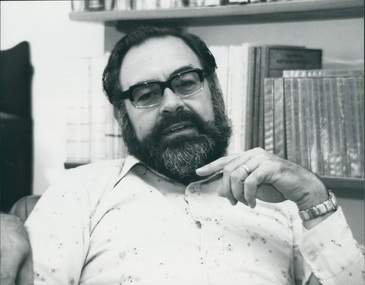
... He announced he was commencing a Christian community to explore and expound the meaning of discipleship. 35 people, mainly young and single, agreed to join him. ...He announced he was commencing a Christian community to explore and expound the meaning of discipleship. 35 people, mainly young and single, agreed to join him. ...Athol Gill was born in Wauchope, NSW, on 5th September 1937. On 25th April 1959 he married Judith Prior. In 1960 he enrolled to become a Baptist minister studying at the Baptist Theological College of NSW. A strong call to higher studies took him to London where he obtained his BD (Hons) and later to Zurich where he attained his Masters and a Doctorate of Theology. Athol lectured in Biblical Studies in both Baptist and Methodist Theological Colleges in Brisbane, moved to Melbourne in 1974 to become Dean of Whitley College, then in 1979 was appointed Professor of New Testament where he continued until his death. He was widely respected for his academic work but also for his remarkable commitment to living the faith he taught. Athol lived, with his family, in Christian Community for nearly all his adult life - in Brisbane at the House of Freedom, and for his last seventeen years as founding leader of the House of the Gentle Bunyip linked with the Clifton Hill Baptist Church, which later became known as the Community Church of St Mark. The House of the Gentle Bunyip came into being in 1975 during the Anzac Day weekend when Athol was teaching on "Discipleship" from the Gospel of St Mark. He announced he was commencing a Christian community to explore and expound the meaning of discipleship. 35 people, mainly young and single, agreed to join him. Athol was a provocative advocate for the poor and for social justice. He campaigned relentlessly for the Church to reflect the teachings of Jesus and for a peaceful and just society. This was evident in his simple lifestyle and through his practical engagement in mission with the poor and marginalised. Honoured in Australia and internationally as a brilliant theologian, teacher and author, Athol is also remembered for his love of sport, especially for the Carlton Football Club, his unique sense of humour and his warm humanity. He died suddenly on 9th March 1992. Head and shoulders of Athol Gill seated in front of bookcaseDr Athol Gill says that the Christians in Yugoslavia are not hoping for a change to Western democracy, but greater human rights under a Communist government. dr athol gill; house of the gentle bunyip -
 Stawell Historical Society Inc
Photograph, Stawell Football Club Club Officials & Trainers at Central Park 1924
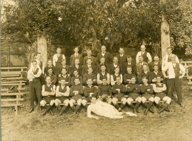
... Jack Neylan (34). Matt Pope (35). XXXXX, (36). Jim Dunn (37). Bill Holmes? ...Jack Neylan (34). Matt Pope (35). XXXXX, (36). Jim Dunn (37). Bill Holmes? ...Club official's trainers and players Stawell Football Club. At central Park 1923. Trees in background. Stawell Football Club Probably 1924 W. Twomey was coach 1922-23, then W. Walton came as coach and Twomey stayed here as a player. J. Bissett was coach in 1926 &1927. Albert Oliver (Secretary); Mat Newton, Bill Twomey, Dunn, Lewis, A (Mick) Dalziel, (Committee), Auggy Greenberger, Davidson, Blachford, Swalwell, Ike Cooper, Jack Curran, Bill? Walton (Coach), G, Mealy, Ike Richards & Richards (Senior), Bert Newton, Stan Freeland, Spoerl (Policeman), George Gilbert, Bill Earle, Norm Gleason, Phillips, Back Row: Jim Phillips, (32). Sam Ross (33)? Jack Neylan (34). Matt Pope (35). XXXXX, (36). Jim Dunn (37). Bill Holmes? (38) in white laying in front of team on the ground. Third Row: Darkie Miller (21). XXXXX, (22). Bert Newton (23). Geo. Gilbert, (24). Stan Freeland, (Sec)(25). W.J. Earle (Senior) Pres. (26). Jack Richards, (27). XXXXX, (28). XXXXX, (29). Bill Lewis, (30). Charlie Oliver, (31). Second Row: ? Trainer? (10). Ros Attrill, (11). XXXXX, (12). Len Clearson? (13). Clarrie Richards, (14). S. Purell, (15). Tony O'Leary? (16). (17). Dick Hewitt, (18). Arthur Hart (Steve), (19). Trainer Angus Dalziel, (20). Front Row: Les Oram (1). Jack Curran, (2). Wingie Ross, (3). Jack Sullivan, (4). Dick Holiday, (5). W. Twomey Captain Coach (6). Tom Swalwell, (7). Ike Cooper, (8). Mick Dalziel (9). Information came From Bert Newton then to Isaac Newton on to son Hartley Newton. Fay Newton. Sepia photographic of a Football Team taken beneath trees and timber seating either side. Also, enlarged sepia copy plus a black & white copy. Also, a black and white print with numbering marked on each person and a page of names responding to the numbers. The original in Photo Drawer 7 has the names handwritten on the back.Post Card Kodak Australiastawell sport -
 Puffing Billy Railway
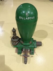
Functional object - Billabong Ram Pump Size #5, Unknown
... The catalogue also provides reference to the company’s ram experience and manufacture, beginning by stating that in 1890 they already had 35 years of experience with Billabong Hydraulic Rams. ...The catalogue also provides reference to the company’s ram experience and manufacture, beginning by stating that in 1890 they already had 35 years of experience with Billabong Hydraulic Rams. ...Pump - Billabong Ram Pump Size #5 Based on available historical data, the Australian-made Billabong Hydraulic Ram is one of the oldest rams produced anywhere in the world The Billabong Hydraulic Ram was first introduced into Australia in 1855 by John Danks and Son Limited, John Danks & Son Pty Ltd began as a plumbing business in 1859, established by brothers John and Samuel. It occupied a prominent site in Bourke Street, Melbourne, for 100 years. The business quickly grew to include factories in Melbourne and Sydney which manufactured and supplied a variety of plumbing and engineering products such as brassware, pumps, windmills and bells. The company was registered in Victoria on 25 January 1889 to continue the hardware manufacturing and supply business founded by brothers John and Samuel Danks in 1859. The head office was based in Bourke Street, Melbourne while another branch was established in Sydney in the 1880s. The company had factories in Melbourne and Sydney. The John Danks and Son Limited catalogue published in 1890, listing Billabong Hydraulic Rams as one of its major machinery products. The catalogue also provides reference to the company’s ram experience and manufacture, beginning by stating that in 1890 they already had 35 years of experience with Billabong Hydraulic Rams. The Hydraulic Ram has stood the test of time and it remains one of the few really practical and efficient uses of natural energy today. It operates without almost any cost, will last indefinitely and, with only two moving parts, is simplicity itself. It requires minimum maintenance and minimum replacement of parts. It is not uncommon to find rams working continuously for many years without any attention. • The Rams do not require electricity, fuel or steam to operate. • They possess simplicity of construction and operation – only 2 moving parts. • Powered only by running water. • Require very minimal or almost no maintenance. • Heavy duty cast Iron base and Dome. This Pump recovered from the Clematis Creek in the Mid 1970's Used to pump water from the creek to the Paradise (Clematis) Hotel. Historic - Farm Equipment - Used to pump water from the creek to the Paradise (Clematis) Hotel.Cast Iron Bronze valveBillabong 5billabong, puffing billy, ram pump -
 Melbourne Tram Museum
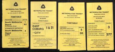
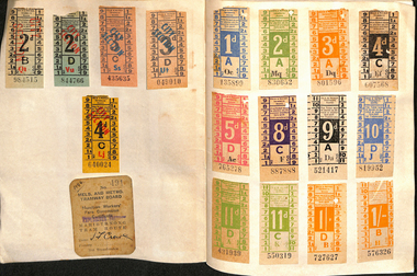
Ephemera - Timetables - Metropolitan Transit - set of 22, Metropolitan Transit Authority (MTA), 1983 and 1984
... ...route 35...Timetables - provides information on fare sections and a route map. 1 - Routes 1, 2 & 4 - South Melbourne - City - July 1984 2 - Route 1 & 21 - East Coburg - City August 1983 3 - Route 5 and 35 - Malvern Burke Road - July 1984 4 - Route 3 and 377 - East Malvern (Darling Road) and bus route on Sundays only - Jan. 1984 5 - Route 6, 36 and 7 - Glen Iris - July 1984 6 - Route 8 and 38 - Toorak - June 1984 7 - Route 9 and 14 - Northcote - June 1984 8 - Route 10 & 11, 13 - West Preston - May 1984 9 - Route 15 & 22 - Moreland - July 1983 10 - Route 15 & 16, 53 & 55 - St Kilda Beach - July 1983 11 - Route 19, 20 and 18 (MMTB) - North Coburg - Oct. 1982 12 - Route 42, 23, 44, 45 and 47 - Mont Albert - July 1984 13 - Route 48, 24, 40, 41 and 29 - North Balwyn - Nov. 1983 14 - Route 57, 357, 54, 60, 58 and 50 - West Maribyrnong - bus on Sundays - July 1984 15 - Route 64, 65, 62 and 61 - East Brighton - Jan. 1984 16 - Route 67, 37, and 66 - Carnegie - Jan. 1984 17 - route 70, 71 and 76 - Wattle Park - June 1984 18 - route 75, 74, 76 and 28 - East Burwood - JIan. 1984 19 - route 77, 78 and 79 - Prahran - North Richmond - July 1984 20 - route 82 and 223 - Footscray - Moonee Ponds and bus on Sundays and Saturdays - June 1984 21 - route 88, 14, 89 and 90 - East Preston - July 1983 22 - route 96, 95 and 97 - East Brunswick - July8 1984...Melbourne Tram Museum 8 Wallen Road Hawthorn melbourne Timetables - provides information on fare sections and a route map. 1 - Routes 1, 2 & 4 - South Melbourne - City - July 1984 2 - Route 1 & 21 - East Coburg - City August 1983 3 - Route 5 and 35 - Malvern Burke Road - July 1984 4 - Route 3 and 377 - East Malvern (Darling Road) and bus route on Sundays only - Jan. 1984 5 - Route 6, 36 and 7 - Glen Iris - July 1984 6 - Route 8 and 38 - Toorak - June 1984 7 - Route 9 and 14 - Northcote - June 1984 8 - Route 10 & 11, 13 - West Preston - May 1984 9 - Route 15 & 22 - Moreland - July 1983 10 - Route 15 & 16, 53 & 55 - St Kilda Beach - July 1983 11 - Route 19, 20 and 18 (MMTB) - North Coburg - Oct. 1982 12 - Route 42, 23, 44, 45 and 47 - Mont Albert - July 1984 13 - Route 48, 24, 40, 41 and 29 - North Balwyn - Nov. 1983 14 - Route 57, 357, 54, 60, 58 and 50 - West Maribyrnong - bus on Sundays - July 1984 15 - Route 64, 65, 62 and 61 - East Brighton - Jan. 1984 16 - Route 67, 37, and 66 - Carnegie - Jan. 1984 17 - route 70, 71 and 76 - Wattle Park - June 1984 18 - route 75, 74, 76 and 28 - East Burwood - JIan. 1984 19 - route 77, 78 and 79 - Prahran - North Richmond - July 1984 20 - route 82 and 223 - Footscray - Moonee Ponds and bus on Sundays and Saturdays - June 1984 21 - route 88, 14, 89 and 90 - East Preston - July 1983 22 - route 96, 95 and 97 - East Brunswick - July8 1984 Yields information about Metropolitan Transit services during the mid 1980s. timetable Metropolitan Transit The Met route 1 route 2 route 4 route 21 route 5 route 35 route 3 route 377 route 6 route 36 route 7 route 8 route 38 route 9 route 14 route 10 route 11 route 13 route 15 route 22 route 16 route 53 route 55 route 19 route 18 route 20 route 42 route 23 route 44 route 45 route 47 route 48 route 24 route 40 route 41 route 29 route 57 route 357 route 54 route 60 route 58 route 50 route 64 route 65 route 62 route 61 route 67 route 37 route 66 route 70 route 71 route 76 route 75 route 74 route 28 route 77 route 78 route 79 route 82 route 223 route 99 route 89 route 90 route 96 route 95 route 97 Set of 22 Metropolitan Transit tram timetables - multifold printed on yellow paper. ...Timetables - provides information on fare sections and a route map. 1 - Routes 1, 2 & 4 - South Melbourne - City - July 1984 2 - Route 1 & 21 - East Coburg - City August 1983 3 - Route 5 and 35 - Malvern Burke Road - July 1984 4 - Route 3 and 377 - East Malvern (Darling Road) and bus route on Sundays only - Jan. 1984 5 - Route 6, 36 and 7 - Glen Iris - July 1984 6 - Route 8 and 38 - Toorak - June 1984 7 - Route 9 and 14 - Northcote - June 1984 8 - Route 10 & 11, 13 - West Preston - May 1984 9 - Route 15 & 22 - Moreland - July 1983 10 - Route 15 & 16, 53 & 55 - St Kilda Beach - July 1983 11 - Route 19, 20 and 18 (MMTB) - North Coburg - Oct. 1982 12 - Route 42, 23, 44, 45 and 47 - Mont Albert - July 1984 13 - Route 48, 24, 40, 41 and 29 - North Balwyn - Nov. 1983 14 - Route 57, 357, 54, 60, 58 and 50 - West Maribyrnong - bus on Sundays - July 1984 15 - Route 64, 65, 62 and 61 - East Brighton - Jan. 1984 16 - Route 67, 37, and 66 - Carnegie - Jan. 1984 17 - route 70, 71 and 76 - Wattle Park - June 1984 18 - route 75, 74, 76 and 28 - East Burwood - JIan. 1984 19 - route 77, 78 and 79 - Prahran - North Richmond - July 1984 20 - route 82 and 223 - Footscray - Moonee Ponds and bus on Sundays and Saturdays - June 1984 21 - route 88, 14, 89 and 90 - East Preston - July 1983 22 - route 96, 95 and 97 - East Brunswick - July8 1984Yields information about Metropolitan Transit services during the mid 1980s.Set of 22 Metropolitan Transit tram timetables - multifold printed on yellow paper.timetable, metropolitan transit, the met, route 1, route 2, route 4, route 21, route 5, route 35, route 3, route 377, route 6, route 36, route 7, route 8, route 38, route 9, route 14, route 10, route 11, route 13, route 15, route 22, route 16, route 53, route 55, route 19, route 18, route 20, route 42, route 23, route 44, route 45, route 47, route 48, route 24, route 40, route 41, route 29, route 57, route 357, route 54, route 60, route 58, route 50, route 64, route 65, route 62, route 61, route 67, route 37, route 66, route 70, route 71, route 76, route 75, route 74, route 28, route 77, route 78, route 79, route 82, route 223, route 99, route 89, route 90, route 96, route 95, route 97 -
 Melbourne Tram Museum
Slide - MMTB, SEC, and VR tramway operations set of 12, Hugh Ballment, 1950s to 1980s
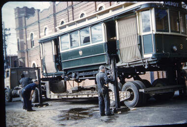
... ...tram 35...HBM157 - MMTB Tram 1041, c9/1973, Spring St, turning into Bourke St soon after issuing to traffic during August 1973 as the dark brown strip on the lower edge of the tram has yet to be painted on it. HBM158 - VR Trams 35, 54, mid to late 1950s, Elwood Depot, In street outside depot HBM159 - MMTB, 1950s, Matthews Ave aerial photo, Lancefield Rd at bottom left. ...HBM157 - MMTB Tram 1041, c9/1973, Spring St, turning into Bourke St soon after issuing to traffic during August 1973 as the dark brown strip on the lower edge of the tram has yet to be painted on it. HBM158 - VR Trams 35, 54, mid to late 1950s, Elwood Depot, In street outside depot HBM159 - MMTB, 1950s, Matthews Ave aerial photo, Lancefield Rd at bottom left. ...Set of 12 photos by Hugh Ballment, unless noted, of MMTB, VR, and MTA: HBM152 - MMTB Trams 1, 604, Dec 1974, Preston workshops, cable set 1 on traverser after MMTB work and 604 in background HBM153 - VR Tram 51, 26/5/1954, Black Rock, Terminus with newsagent and beauty salon in the background, see also image HBM170 HBM154 - MMTB Tram 658, 1950s, St Georges Rd, At Miller St HBM155 - MMTB Trams 678, 180, early 1960s, Leeds St, Footscray station, with an X1 leaving for Williamstown Road. In the background is Cummings Chemist advertising Kodak film, along with a group of trammies standing around the Bundy Clock. In the far background, a Laundry and I M Collins advertising Phillips radios and televisions. HBM156 - MMTB Tram 880, 26/05/1954, Swanston St, At Lonsdale St. with dash canopy lighting with destination of route 6 Glen Iris. In the background is a sign advertising Empire Day 24/5/1954, Renwick Pride Printers, Drossous Restaurant, with an advert for Stonyfell wines. HBM157 - MMTB Tram 1041, c9/1973, Spring St, turning into Bourke St soon after issuing to traffic during August 1973 as the dark brown strip on the lower edge of the tram has yet to be painted on it. HBM158 - VR Trams 35, 54, mid to late 1950s, Elwood Depot, In street outside depot HBM159 - MMTB, 1950s, Matthews Ave aerial photo, Lancefield Rd at bottom left. Matthews Ave appears to be unmade. HBM160 - MMTB Tram 87, c1985, Flemington Rd, Looking toward Haymarket with the flagpole that was erected during 1984 - see https://www.melbourne.vic.gov.au/haymarket-flagpole HBM161 - c1900, Bouke St east from Elizabeth St, from a high viewpoint. Telephone pole lines remain in view along with many horse-drawn vehicles. Yields information about Melbourne tram operations, with 1950s to 1980s photos of Melbourne tramways.Kodachrome cardboard and plastic mounts, with notes - set of 12new tramway, preston workshops, tram 880, tram 1041, swamston st, elwood depot, bourke st, cable trams, tram 35, tram 54, matthews ave, essendon aerodrome, tram 87, flemington road, haymarket -
 Ballarat Tramway Museum
Film - Movie Film & Box, Kodak, 1960
... inbound passes away from the camera through the Victoria Park or Morrison St loop, swinging out into the roadway. 28:29 View of timetable sign at Hamilton Ave. 28:37 35 turning from Sturt St West into Hamilton Ave, can see the conductor changing over the barrier rails. 29:11 42 inbound, crosses another bogie tram (35?) ...inbound passes away from the camera through the Victoria Park or Morrison St loop, swinging out into the roadway. 28:29 View of timetable sign at Hamilton Ave. 28:37 35 turning from Sturt St West into Hamilton Ave, can see the conductor changing over the barrier rails. 29:11 42 inbound, crosses another bogie tram (35?) ...Yields information in movie film format of Ballarat trams in 1960, how the system operated and was used by people., Yields information in movie film format of Ballarat trams in 1960, how the system operated and was used by people.Movie film - 8mm, approx. 30mins, with leader strip on a plastic reel, within a black and white plastic box, titled "Ballarat No. 1. 1960". Has been transferred to DVD - see Reg item 4100 as Segment No. 2. Made by Ben Parle. Also transferred to DVD by Rod Cook Oct. 2015, via Roger Greenwood for use in his DVD, "The City of Ballarat Trams, Gardens & Gold" of 2016. See Reg Item 6883. Synopsis: based on time. 0:00 View of typed introduction, noting that this is a pictorial record of Ballarat. 0:10 Title “The Tramways of Ballarat 1960, Part 1” 0:16 13, showing “View Point” at Stones Corner, Bridge St, east end, with trolley pole being turned, while another single trucker heads out towards Mt Pleasant. 0:25 13 leaving Stones Corner, short approach and then longer trailing shot of the tram going towards the City in Bridge St. 0:44 View out of front of tram in Bridge St heading towards the City, with cars in the photo, then passing through city Loop, no trams in the loop and running up to Lydiard St Nth and crossing the road. 1:22 Running up Sturt St from Armstrong St, passes over Dawson St X-over and up to the next intersection, Lyons St. 1:54 Title “The View Point Line” 1:59 19 inbound, in Ripon St, from crossing Mair St, towards camera and then passing away and turning into Sturt St. 2:49 View of a “Warning Oncoming Trams” sign 2:52 19 in Ripon St, going to View Point, crossing Webster St towards camera, then going away through the disconnected Victoria Ave loop, pass the “Warning Oncoming Trams” sign. Note very windy scene with people running across roads. 3:17 19 in Wendouree Parade, in bound, though showing destination View Point, going away from the camera, past the View Point Hotel. 3:39 19 coming towards camera near Excerpt or Devon St and then going away towards the terminus. 4:04 19 at the terminus, stationary, with a single trucker 3?, passing from Macarthur St into Wendouree Parade, behind 19. 4:20 33 coming towards camera in Wendouree Parade from St Aidans Drive, stopping to pick up passenger at Forest St and then going away towards the City, photographed from near the depot, on a wet and windy day. 4:54 35 in Wendouree Parade, coming towards the Camera from St Aidans Drive and then going away with the Gardens Loop area in the background. Tram stops at stop to let a passenger off. 5:28 21 leaving Gardens Loop for the City via the Depot, green light in signal can be seen. 5:43 28?, closely followed by 26 turn from Drummond St South into Sturt St. 6:18 Scene opens with shot of “Sebastopol” destination on a bogie tram. 6:21 Title “The Sebastopol Line” 6:24 21 turning from Sturt St into Drummond St Sth with destination of Bell St and then going away from the camera. 6:55 38 in Drummond St Sth, coming towards the camera and then passing the camera with Sturt St just in the view. 7:10 21, showing Gregory St, in Drummond St Sth, approaching and then going away, entering the Urquhart St Loop, 7:39 34 in Drummond St Sth (location check required (Latrobe?)), approaches camera, picks up passengers and the goes away. 8:09 39 at ? Street, turns from Drummond St Sth into Skipton St, after picking up and setting down passengers, bound for Sebastopol 8:55 35 inbound in Skipton St passes through the Bell Street Loop, and then goes away from the camera. 9:33 42 outbound in Skipton St, approaches the camera, passes and then crosses over the half the road into Albert St. 10:00 39 inbound in Albert St – location? 10:31 34 outbound for Sebastopol, approaches camera and just starts to pass by. 10:36 34 in Grey St crossing loop, crosses 42 inbound. 10:59 39 outbound in Albert St, with shopping centre in bound, approaches camera, passes and then crosses over Albert St. Mid morning scene. 11:39 39 inbound, Albert St south, approaches camera and then passes and the crosses over Albert St. 12:16 41 outbound in Albert St passes the camera, and pulls into the terminus with the conductor getting out on the back bumper to pull the pole down as the tram stops and a passenger walks into the Royal Hotel. 12:39 Title “The Lydiard Street North Line” 12:44 Filmed from the Hotel balcony, 21 inbound in Lydiard St Nth passes over Mair St, stops while 33 passes in the other direction. 13:18 With the red light showing on the Seymour St loop signal, 33 inbound for Sebastopol stops and picks up many passengers, passes the camera and runs past the VRI building in the background and through the loop. Possibly filmed on a Sunday given the ladies dresses and quieter streets. 14:01 30 outbound, passes the camera and stops at Macarthur St. Filmed alongside the brick wall of the cutting. 14:28 30 inbound arrives, passes through the Gregory St loop and then proceeds past the camera, making a stop to pick up passengers. 15:14 28 in Lydiard St Nth – location?, approaches and goes away from the camera, north of Gregory St. 15:34 28 ditto location? 15:53 21 arrives at the terminus with passengers getting on and off. 16:11 View of the a vertical positioned “End of Section” sign on a pole at the terminus and then lifting the camera to see the timetable board and the stop sign. 16:33 31 in Bridge St passing Morseheads and then turning into Sturt St, stops at the Grenville St stop, while another single trucker comes down to the stop from the City. 16:58 31 outbound in Bridge St, with destination of Victoria St. 17:14 Title “The Victoria Street Line” 17:18 31 outbound to Victoria St from Stones Corner. Starts with an overhead shot, shows clock at the Caltex service station,. 17:37 31 inbound approaching Bakery Hill and then descending to the junction after it passes camera. 18:09 25 climbing outbound in Victoria St, passing the camera, to then pass through the King St loop. 18:47 25 inbound in Victoria St, passing the camera, then pass through the King St loop, with St Alypius Church in the background. 19:36 14 approaching the rail bridge in Victoria St and stopping at the 2nd last stop to left of passengers. 20:01 14 leaving the terminus and approaching the camera and the a short sequence going away, to the next stop to pick up quite a few passengers. 20:14 “Trams Stop Here” sign, metal wrap around on a steel pole. 20:16 Title “The Mount Pleasant Line” 20:21 11 inbound in Main St, with a passenger leaping off the tramcar and another getting off just before the junction. 20:45 11 passes the junction and then proceeds away from the camera in Bridge St. 21:04 30 outbound in Main St, then turns into Barkly St, a bus (Eclipse Motors) passes in Main St just before the sequence ends. 21:31 30 inbound near Steinfield St. (exact location?) 21:49 25 approaches the camera, then proceeds away and passes through the Grant St. loop. 22:29 25 inbound, windy day, between Grant and Cobden, (exact location?), with a horse drawn bread van in the view and the breadman walking behind the tram as it passes. 23:02 11 outbound in Barkly St, (exact location?) 23:37 11 inbound in Barkly St (exact location?) 23:44 Mt Pleasant terminus signage 23:50 30 approaches the terminus and then stops with the conductor alighting turning the pole, passengers getting on and off and the driver appearing at the other end. 24:32 Title “The Gardens Via Sturt St. West Line” 24:35 21 outbound in Sturt St near Raglan St, approaches and passes the Camera. 25:09 12, showing City Oval, approaches and passes the camera, outbound near Windermere St. 25:33 13 showing View Point, goes away from the camera – location? 25:44 12 comes from St. West, inbound passes the camera and then stop as the next stop next Talbot St? 26:21 Short sequence of a “Warning Oncoming Trams” sign 26:28 42 inbound in Sturt St West, just before Ripon St, view coming towards camera and then going away to cross Ripon St. 27:10 34 passes through the Parker St loop 27:25 35 or 39 inbound past the college in Sturt St West 28:04 41 outbound at the Russell St curve, passes away from the camera. 28:11 35? inbound passes away from the camera through the Victoria Park or Morrison St loop, swinging out into the roadway. 28:29 View of timetable sign at Hamilton Ave. 28:37 35 turning from Sturt St West into Hamilton Ave, can see the conductor changing over the barrier rails. 29:11 42 inbound, crosses another bogie tram (35?) at Carlton St loop then passes the camera and goes past the Olympic rings monument. 29:42 12 approaches the Carlton St gates. 30:07 12 outbound, crosses a bogie tram in the loop with both trams then leaving the loop. 30:20 Title “End of Part One” Written labels giving title information on outside of box.trams, tramways, ballarat, sebastopol, lydiard st north, victoria st, mt pleasant, sturt st west -
 Mission to Seafarers Victoria
Journal (item) - Periodicals-Annual, Shiplovers' Society of Victoria, The Annual Dog Watch
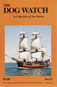
... Springthrope - 33 The Australians return to the Phillipines - W.S. McUtchen - 35 Sunbathing is good for the eyes - Capt. ...Springthrope - 33 The Australians return to the Phillipines - W.S. McUtchen - 35 Sunbathing is good for the eyes - Capt. ...This journal provides the reader with glimpses of the adventures and hardships of a seaman's life. Many of the stories are of sailing ships.Contributes to our knowledge of the importance of shipping and places on record those stories of the sea which would otherwise be lost.Contents Editorial - - 5 Adelaide to Sydney on the Endeavour - P. Kelly - 7 A tribute to Capt. G.A. Molyneux - T.E. Goldfinch - 27 The Bos’n’s Chair - R.N. Thiele - 29 A Gallant Steward - B. Springthrope - 33 The Australians return to the Phillipines - W.S. McUtchen - 35 Sunbathing is good for the eyes - Capt. R. Hart - 49 William Thomas, The Liverpool Shipowner & the Holyhead — wrecked on Point Lonsdale - G.I. Hawkes - 50 “Seahorses” - G.M. Naug - 56 Henry Greathead 1757-1813 Inventor of the Lifeboat - B.M. Morris - 57 The Milag Book - K. Shewan - 63 Life & Death of a Shipyard - E. Pennell - 65 A Donkey’s Breakfast & Parish Rig - W.P. Shemmeld - 69 The Indian Rope Trick — witnessed - R.A. Bloom - 74 MV Otaio, Training for the Sea at Sea - J. Giles - 77 “Sailorman” - N. Smith - 85 Can you solve the mystery? K.S. - 87 A Norwegian apprentice in the 1930s - Capt. G. Skomedal - 88 Snippets from the papers of Alexander McLennan — Sailmaker - J. McLennan - 103 A Mother’s Letter - B.M. Morris - 106 The Carrick ex City of Adelaide - R.C. Shepherd - 108 Book Reviews - - 111sailing ships, steamships, shipping, seafaring life, shiplovers' society of victoria, dog watch -
 Ringwood and District Historical Society
Photograph, North Ringwood & South Warrandyte residents beach picnic. c1905
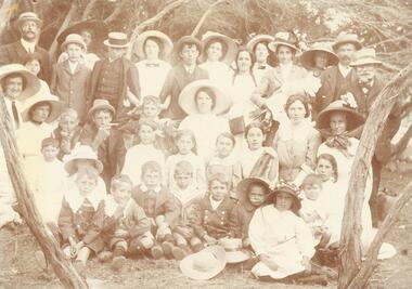
... Harry Tortice, 34. Millie Mitchell, 35. Florrie Tortice, 36. Bill Tortice, 37 Emily Tortice."...Harry Tortice, 34. Millie Mitchell, 35. Florrie Tortice, 36. Bill Tortice, 37 Emily Tortice." ...Black and white photograph (2 copies- 1 large, 1 small) Smaller photograph with numbers and identification attached reads as follows: "North Ringwood & South Warrandyte residents beach picnic c1905. Photo from M. zoch, Hardings Rd. South Warrandyte. 1. Mr. Daniels, 2. Marion Coleman, 3. V. Zoch, 4. Mrs. Daniels, 5. Len Milne, 6. Miss D. Coleman, 7. Mick Johansen, 8. Mrs. Johansen, 9. Miss A. Sloan, 10. Mrs. Hussey, 11. Mrs. B. Milne, 12. Mrs. Tortice, 13. Bert Milne, 14. P. Coleman, 15. Miss J. Tortice, 16. Miss S. Tortice, 17 May Tortice, 18. Mrs.J. Coleman, 19. Claude Milne, 20. Rosie Johansen, 21, M. Zoch, 22 Harold Milne, 23. Miss O. Johansen, 24. Miss F. Sloan, 25. Eileen Mitchell, 26. Amy Johansen, 27. Roy Milne, 28. Stan Milne, 29. Dave Coleman, 30. Bell Mitchell, 31. Reg Daniels, 32. Vicki Tortice, 33. Harry Tortice, 34. Millie Mitchell, 35. Florrie Tortice, 36. Bill Tortice, 37 Emily Tortice." -
 Ringwood and District Historical Society
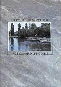
Book, City of Ringwood, City of Ringwood 1992 Community Guide, 1992
... CONTENTS: (page no.) 1991/92 COUNCIL REPRESENTATIVES 4 1992 CALENDAR 51 AQUATIC CENTRE 8 AQUATIC CENTRE VOUCHERS 49 CHIEF EXECUTIVE'S REPORT 6 CIVIC CENTRE TELEPHONE INDEX — DIRECT DIALLING 53 COMMUNITY DIRECTORY 35-47 COMMUNITY SERVICES 17-19 COUNCIL & COMMITTEE CYCLES 4 COUNCIL FINANCES & 1991/92 RATES 16 COUNCILLORS 3 FUNCTIONAL RESPONSIBILITIES 15 HISTORY OF RINGWOOD 5 HOUSING & RESIDENTIAL DEVELOPMENT 29-30 INFRASTRUCTURE 34 LOCAL, STATE & FEDERAL GOVERNMENT ELECTIONS 32 MANAGEMENT TEAM 14 MAYORAL MESSAGE – Cr. ...Ringwood and District Historical Society 125A Warrandyte Road Ringwood North melbourne rinx CONTENTS: (page no.) 1991/92 COUNCIL REPRESENTATIVES 4 1992 CALENDAR 51 AQUATIC CENTRE 8 AQUATIC CENTRE VOUCHERS 49 CHIEF EXECUTIVE'S REPORT 6 CIVIC CENTRE TELEPHONE INDEX — DIRECT DIALLING 53 COMMUNITY DIRECTORY 35-47 COMMUNITY SERVICES 17-19 COUNCIL & COMMITTEE CYCLES 4 COUNCIL FINANCES & 1991/92 RATES 16 COUNCILLORS 3 FUNCTIONAL RESPONSIBILITIES 15 HISTORY OF RINGWOOD 5 HOUSING & RESIDENTIAL DEVELOPMENT 29-30 INFRASTRUCTURE 34 LOCAL, STATE & FEDERAL GOVERNMENT ELECTIONS 32 MANAGEMENT TEAM 14 MAYORAL MESSAGE – Cr. ...Community information book issued by City of Ringwood for 1992 - covering the facilities and activities of the Ringwood Council and other local organisations and associations. Includes two Aquatic Centre entry vouchers valid until June 30th, 1992.CONTENTS: (page no.) 1991/92 COUNCIL REPRESENTATIVES 4 1992 CALENDAR 51 AQUATIC CENTRE 8 AQUATIC CENTRE VOUCHERS 49 CHIEF EXECUTIVE'S REPORT 6 CIVIC CENTRE TELEPHONE INDEX — DIRECT DIALLING 53 COMMUNITY DIRECTORY 35-47 COMMUNITY SERVICES 17-19 COUNCIL & COMMITTEE CYCLES 4 COUNCIL FINANCES & 1991/92 RATES 16 COUNCILLORS 3 FUNCTIONAL RESPONSIBILITIES 15 HISTORY OF RINGWOOD 5 HOUSING & RESIDENTIAL DEVELOPMENT 29-30 INFRASTRUCTURE 34 LOCAL, STATE & FEDERAL GOVERNMENT ELECTIONS 32 MANAGEMENT TEAM 14 MAYORAL MESSAGE – Cr. Max Williams 1 NEIGHBOURHOOD MAP 26-27 NOTES 52 PAPER & CARDBOARD COLLECTION SERVICE 22 PARKS & RESERVES — PUBLIC FACILITIES 31 PROTECTING OUR COMMUNITY 23-24 PROTECTING THE ENVIRONMENT 20-21 RINGWOOD FESTIVAL & HIGHLAND CARNIVAL 13 RINGWOOD GOLF COURSE 7 STRATEGIC BIKE PLAN 11 STREET INDEX A-L 25 STREET INDEX L-Z 28 THE LIBRARY 12 THE RINGWOOD CONVENTION & PERFORMING ARTS CENTRE 10 TRAFFIC MANAGEMENT 33 YOUR PERSONAL DIRECTORY 50 rinx -
 Bendigo Historical Society Inc.
Document - MCCOLL, RANKIN AND STANISTREET COLLECTION: ANGOVE AND CARRS LEASE, DIAMOND HILL, 1935
... Inscriptions: G Birch advises 16/5/35. Survey made by Assistant he has yet to receive. 10710 W J Angove - Spring Gully PO. ...Inscriptions: G Birch advises 16/5/35. Survey made by Assistant he has yet to receive. 10710 W J Angove - Spring Gully PO. ...McColl Rankin & Stanistreet, Angove & Carrs Lease, Diamond Hill. a/ Manila folio Markings: Angove & Carrs Lease Diamond Hill. Freed?aus Extended. b/ Plan Area Applied For On Lease No. 10103 Ben. By A A Macintosh. Mining District of Bendigo Parish of Mandurang County of Bendigo. Inscriptions: G Birch advises 16/5/35. Survey made by Assistant he has yet to receive. 10710 W J Angove - Spring Gully PO. Dated August 12th 1933 signed: Garnet G Birch J Victor Buley. c/ Agreement of lease for 1 month with the option of 9 months, followed by the option of purchase between Summerhill Anticlines NL of Adelaide and Angove & Carr at German Gully (Mandurang). Markings: 25/3/13 note by Summerhill Anticline NL. Requests information as to whether or not the Syndicate (E Mann, W Angove & H Irvine, H. Mc……….) desire to take up the options of lease or not. d/ Notice to Shareholders of a meeting in Collins Street Melbourne. 6 March, 1935 to consider proposals of the future of the company. J G Stanfield & Stewart, Manager. e/ Neangar Gold Mining Company NL 6 Month Report 27/2/1935 Business, Director's Report & Financial Report. f/ Report by A J J Moore BCE Mining Engineer, Ramrod Lease, Golden Fleece Mine near Spring Gully Reservoir the most Southern mine being Worked in Bendigo. Lease in on the Carshalton line. Report details the progress of the workings at the mine.organization, business, gold mine, mccoll rankin & stanistreet, angove & carrs lease, diamond hill a a macintosh parish of mandurang county of bendigo w j angove august 12th 1933 summerhill anticlines 6 month report 27/2/1935 golden fleece mine near spring gully reservoir -
 Federation University Historical Collection
Album pages, Photographic Biographies of former 1947 Ballarat Teachers' College students
... Pages from a large photograph album with photographs and handwritten reminiscences relating to students at the Ballarat Teachers' College in 1947. .1) Athol Aisbett .2) Nance Alexander, Jess Batson, Eddie Blake .3) Phyllis Borley .4) Keith Boyd .5) Owen Brennan, Josie Bunney, Ron Carless .6) David Cooper .7) Inez Domaschenz .8) Jean Clode, John Collins, Colin Collins .9) Dawn Doney, Fay Dreher .10) John Ellison, Ethel White .11) Hugh Fraser, Joyce Mathison .12) Marie Faulds, Robert Giddings .13) Val Gorrie, Bill Gleeson, Joan Gunning .14) Bill Henderson .15) Pat Luxford .16) Tom Hill, Nancy Kerr, Lindsay Harley .17) Keith McClean .18) Claire Kennedy, Keith McLean .19) Ann McKinnon .20) Maurine Merlin, Joyce Kennedy .21) Fred Marshman .22) Howard Pattenden .23) Milton Rice .24) Mayvis Poland, Bill Punshon .25) Pat Robinson .26) Pat Watts .27) Betty Williams, Jim Williams .28) Lorna Welsh, Neila Vallance .29) Kath Tobin, Jack Tyers .30) Burns Roddis .31) Howard .32) Owen Brennan .33) Colin Connelly .34) Jack Mallett .35) Black display book of correspondence and death notices relating to former 1947 Ballarat Teachers' College Students...Pages from a large photograph album with photographs and handwritten reminiscences relating to students at the Ballarat Teachers' College in 1947. .1) Athol Aisbett .2) Nance Alexander, Jess Batson, Eddie Blake .3) Phyllis Borley .4) Keith Boyd .5) Owen Brennan, Josie Bunney, Ron Carless .6) David Cooper .7) Inez Domaschenz .8) Jean Clode, John Collins, Colin Collins .9) Dawn Doney, Fay Dreher .10) John Ellison, Ethel White .11) Hugh Fraser, Joyce Mathison .12) Marie Faulds, Robert Giddings .13) Val Gorrie, Bill Gleeson, Joan Gunning .14) Bill Henderson .15) Pat Luxford .16) Tom Hill, Nancy Kerr, Lindsay Harley .17) Keith McClean .18) Claire Kennedy, Keith McLean .19) Ann McKinnon .20) Maurine Merlin, Joyce Kennedy .21) Fred Marshman .22) Howard Pattenden .23) Milton Rice .24) Mayvis Poland, Bill Punshon .25) Pat Robinson .26) Pat Watts .27) Betty Williams, Jim Williams .28) Lorna Welsh, Neila Vallance .29) Kath Tobin, Jack Tyers .30) Burns Roddis .31) Howard .32) Owen Brennan .33) Colin Connelly .34) Jack Mallett .35) Black display book of correspondence and death notices relating to former 1947 Ballarat Teachers' College Students Photographic Biographies of former 1947 Ballarat Teachers' College students Album pages ...Gathered over the years as the result of Ballarat Teachers' College reunions.Pages from a large photograph album with photographs and handwritten reminiscences relating to students at the Ballarat Teachers' College in 1947. .1) Athol Aisbett .2) Nance Alexander, Jess Batson, Eddie Blake .3) Phyllis Borley .4) Keith Boyd .5) Owen Brennan, Josie Bunney, Ron Carless .6) David Cooper .7) Inez Domaschenz .8) Jean Clode, John Collins, Colin Collins .9) Dawn Doney, Fay Dreher .10) John Ellison, Ethel White .11) Hugh Fraser, Joyce Mathison .12) Marie Faulds, Robert Giddings .13) Val Gorrie, Bill Gleeson, Joan Gunning .14) Bill Henderson .15) Pat Luxford .16) Tom Hill, Nancy Kerr, Lindsay Harley .17) Keith McClean .18) Claire Kennedy, Keith McLean .19) Ann McKinnon .20) Maurine Merlin, Joyce Kennedy .21) Fred Marshman .22) Howard Pattenden .23) Milton Rice .24) Mayvis Poland, Bill Punshon .25) Pat Robinson .26) Pat Watts .27) Betty Williams, Jim Williams .28) Lorna Welsh, Neila Vallance .29) Kath Tobin, Jack Tyers .30) Burns Roddis .31) Howard .32) Owen Brennan .33) Colin Connelly .34) Jack Mallett .35) Black display book of correspondence and death notices relating to former 1947 Ballarat Teachers' College Students -
Clunes Museum
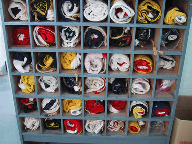
Domestic object - LACE MAKER
... Spider insertion, Copenhagen Lace, Plain Hole Ground, Ornamental Ground Pin Check, Block Lace, Spider Lace, No. 18 Medici Lace, ZigZag Lace, Wide Antique Lace, Diamond Antique Edging, Block Lace, Jewel Insertion, Edging No. 24, Spider Lace, Zig-Zag Lace, Medici Lace, No. 21 Maltese Lace. .10 .35 x bobbins (8 with cotton) .11 2 x cream coloured lace doyleys with square linen damask machine sewn into the centre of the doyley. .12 Large wooden cotton reel with cream coloured lacemaking thread ...Spider insertion, Copenhagen Lace, Plain Hole Ground, Ornamental Ground Pin Check, Block Lace, Spider Lace, No. 18 Medici Lace, ZigZag Lace, Wide Antique Lace, Diamond Antique Edging, Block Lace, Jewel Insertion, Edging No. 24, Spider Lace, Zig-Zag Lace, Medici Lace, No. 21 Maltese Lace. .10 .35 x bobbins (8 with cotton) .11 2 x cream coloured lace doyleys with square linen damask machine sewn into the centre of the doyley. .12 Large wooden cotton reel with cream coloured lacemaking thread Domestic object LACE MAKER ...Includes; .1 Lace Maker .2 3 x samples of lace .3.Bill of Sale dated 7 March 1916 payment received with thanks C.H Coombe .4 Price list of Torchon Lace Co.229 Collins Street, Melbourne, Victoria, Australia .5The Torchon Lace Making Booklet, 12th edition, copyright 1904 .6 Letter (undated) offering The complete lacemaking outfit .7 Document with customer reviews .8 Booklet "The Torchon Lace Maker (illustrated) Copy right 1904 All rights Reserved .9 30 x cardboard lace making patterns No. 20 Torchon Edging, Diamond Point Edging, Net Ground, 2 x Round Point Edging, Edging No. 11, Diamond Antique Edging, Jewel Insertion, Smyrna Edging, Rose Ground, Edging No. 24, Insertion No. 22, No.5 Twisted Hole Ground with "Spider". Spider insertion, Copenhagen Lace, Plain Hole Ground, Ornamental Ground Pin Check, Block Lace, Spider Lace, No. 18 Medici Lace, ZigZag Lace, Wide Antique Lace, Diamond Antique Edging, Block Lace, Jewel Insertion, Edging No. 24, Spider Lace, Zig-Zag Lace, Medici Lace, No. 21 Maltese Lace. .10 .35 x bobbins (8 with cotton) .11 2 x cream coloured lace doyleys with square linen damask machine sewn into the centre of the doyley. .12 Large wooden cotton reel with cream coloured lacemaking thread .1 White sticker, "63" printed in black placed on Lace Maker .12 Eagley imprinted into one end of the reellace making machine, christina mckenzie lawrence -
 Southern Sherbrooke Historical Society Inc.
Photograph - Spykers family at Avonsleigh c.1960
... Within a year he had paid a deposit on a broken-down property of 35 acres in the Dandenong ranges. His family joined him and they started to rehabilitate their new property. ...Within a year he had paid a deposit on a broken-down property of 35 acres in the Dandenong ranges. His family joined him and they started to rehabilitate their new property. ...Black and white photo showing a large family group in a flower field. In the background there are low hills with cleared paddocks and forested areas. According to the National Archives of Australia: 'Land was life for nurseryman Theo Spykers and his ancestors who had tilled the soil for generations; good land to own and to pass on to sons and their sons. At 42 Theo had one and a half acres near Rotterdam for a prosperous nursery, but he could only rent it and his family was growing. So, in 1948, Theo left his wife and six children at their home and set off by himself for Australia. Within a year he had paid a deposit on a broken-down property of 35 acres in the Dandenong ranges. His family joined him and they started to rehabilitate their new property. Mr and Mrs Spykers and twelve of their thirteen children pick chrysanthemums for sale in Melbourne, a city of 1,750,000. The children are; Theo, 20; Gerald, 15; Niko, 8; Frank, 5; Adolf, 22; Corrie, 11; Ria, 18; Terisa, 4; Anthony, 7; Tommy, 2; Elly, 10; Bill, 16.' Mr & Mrs Spykers are each holding one of the smaller children. This farm was on the corner of Birds Rd and Avon Rd, Avonsleigh. On the NAA records, Theodorus Gerardus Spykers arrived in Melbourne on the Muiderkerk on 27th February 1948. Black and white photo showing 15 year old Gerald Spykers carrying bundles of chrysanthemums tied ready for market. He is at the family farm on the corner of Birds Rd and Avon Rd, Avonsleigh. -
 Melbourne Tram Museum
Ephemera - Timetable/s, Public Transport Victoria (PTV), Set of 25 digital timetables, 2018
... ... Route 35...Route 1 - East Coburg - South Melbourne Beach Route 3 and 3A - Melbourne University - East Malvern - and via St Kilda Beach Route 5 - Melbourne University - Malvern Route 6 - Melbourne University - Glen Iris Route 8 - Moreland - Toorak Route 11 - West Preston - Victoria Harbour Docklands Route 12 - Victoria Gardens - St Kilda Route 16 - Melbourne University - Kew Via St Kilda Route 19 - North Coburg - Flinders St Route 30 - St Vincent's Plaza - Etihad Stadium Docklands Route 35 - City Circle Route 48 - North Balwyn - Victoria Harbour Docklands Route 55 - West Coburg - Domain Interchange Route 57 - West Maribyrnong - Flinders St Route 59 - Airport West - Flinders St Route 64 - East Brighton - Melbourne University Route 67 - Carnegie - Melbourne University Route 70 - Wattle Park - Waterfront City Docklands Route 72 - Camberwell - Melbourne University Route 75 - Vermont South - Etihad Stadium Docklands Route 78 - North Richmond - Balaclava via Prahran Route 82 - Footscray - Moonee Ponds Route 86 - Bundoora RMIT - Waterfront City Docklands Route 96 - East Brunswick - St Kilda Beach Route 109 - Box Hill - Port Melbourne...Melbourne Tram Museum 8 Wallen Road Hawthorn melbourne Trams tramways Timetables Yarra Trams Route 1 Route 3 Route 5 Route 6 Route 8 Route 11 Route 12 Route 16 Route 19 Route 30 Route 35 Route 48 Route 55 Route 57 Route 59 Route 64 Route 67 Route 70 Route 72 Route 75 Route 78 Route 82 Route 86 Route 96 Route 109 Set of 25 digital timetables generally applicable from 20-05-2018 following the introduction of more frequent services on many routes. ...Set of 25 digital timetables generally applicable from 20-05-2018 following the introduction of more frequent services on many routes. Image files are htd2860iRx - x being the route number. Route 1 - East Coburg - South Melbourne Beach Route 3 and 3A - Melbourne University - East Malvern - and via St Kilda Beach Route 5 - Melbourne University - Malvern Route 6 - Melbourne University - Glen Iris Route 8 - Moreland - Toorak Route 11 - West Preston - Victoria Harbour Docklands Route 12 - Victoria Gardens - St Kilda Route 16 - Melbourne University - Kew Via St Kilda Route 19 - North Coburg - Flinders St Route 30 - St Vincent's Plaza - Etihad Stadium Docklands Route 35 - City Circle Route 48 - North Balwyn - Victoria Harbour Docklands Route 55 - West Coburg - Domain Interchange Route 57 - West Maribyrnong - Flinders St Route 59 - Airport West - Flinders St Route 64 - East Brighton - Melbourne University Route 67 - Carnegie - Melbourne University Route 70 - Wattle Park - Waterfront City Docklands Route 72 - Camberwell - Melbourne University Route 75 - Vermont South - Etihad Stadium Docklands Route 78 - North Richmond - Balaclava via Prahran Route 82 - Footscray - Moonee Ponds Route 86 - Bundoora RMIT - Waterfront City Docklands Route 96 - East Brunswick - St Kilda Beach Route 109 - Box Hill - Port Melbournetrams, tramways, timetables, yarra trams, route 1, route 3, route 5, route 6, route 8, route 11, route 12, route 16, route 19, route 30, route 35, route 48, route 55, route 57, route 59, route 64, route 67, route 70, route 72, route 75, route 78, route 82, route 86, route 96, route 109 -
 Parks Victoria - Wilsons Promontory Lightstation
Flags, Navigational
... . • 1. navy & white. 2. navy & yellow. 3. navy & white. 4. white. 5. red & yellow. 6. yellow & navy. 7. yellow & navy. 8.red. 9.red & white. 10. white & navy. 11. red & navy & white. 12.yellow & navy & & red. 13.navy & white. 14. navy & white. 14. navy & white. 15.navy & white. 16. navy & yellow. 17. yellow & white. 18. white & red. 19. white & red. 20. yellow & red. 21. white & navy. 22. yellow & navy. 23. navy & white. 24. white & navy. 25.red & white. 26. navy & white. 27.red & white. 28.red & white. 29. red & navy. 30. white & navy. 31. yellow. 32.red 7 navy. 33. red. 34 navy,white,red & yellow.35. red & blue. 36. white & red. 37. navy & yellow. 38.red, yellow & white. 39. white. 40. white & red. 41. yellow & red. 42.navy. 43.custom built wooden open cupboard divided into sections to house flags..... • 1. navy & white. 2. navy & yellow. 3. navy & white. 4. white. 5. red & yellow. 6. yellow & navy. 7. yellow & navy. 8.red. 9.red & white. 10. white & navy. 11. red & navy & white. 12.yellow & navy & & red. 13.navy & white. 14. navy & white. 14. navy & white. 15.navy & white. 16. navy & yellow. 17. yellow & white. 18. white & red. 19. white & red. 20. yellow & red. 21. white & navy. 22. yellow & navy. 23. navy & white. 24. white & navy. 25.red & white. 26. navy & white. 27.red & white. 28.red & white. 29. red & navy. 30. white & navy. 31. yellow. 32.red 7 navy. 33. red. 34 navy,white,red & yellow.35. red & blue. 36. white & red. 37. navy & yellow. 38.red, yellow & white. 39. white. 40. white & red. 41. yellow & red. 42.navy. 43.custom built wooden open cupboard divided into sections to house flags. ...The forty-two navigational flags appear to be a complete set. Their purpose-built, grey painted wooden locker is divided into forty-two pigeonholes, each holding one of the rolled up flags. It is simply built and stands on short legs and was originally open-fronted, but has since been covered with a protective clear Perspex panel. The set of alphabetic and numeric visual signalling flags (including substitute and answering pennants) are made of wool in various colour combination designs, with canvas sewn to one end that is threaded with hemp rope. Some of the flags have metal clips attached to the rope. The flags were used for communicating messages to passing ships. Knowledge of visual signalling was mandatory for all lightkeepers and all stations maintained a set of flags. Although used for centuries, visual flag signalling formally developed in the nineteenth century and was published internationally as a system in 1857. By the early twentieth century it had developed into an effective means of conveying all kinds of short range visual messages. Most flags are in good condition and their first level significance is enhanced by their completeness and integrity as a set still housed in their original locker, and by the signal charts that remain in the museum collection which offer further insights into visual signalling.1 - 42. Navigational flag set of 42 individual flags. Coloured linen with canvas sewn to one end which has hemp rope threaded through it. Some flags have metal clips attached to the ends of the hemp rope. 43. Wooden cupboard divided into sections with wooden divides. Used to house the 42 flags. • 1. navy & white. 2. navy & yellow. 3. navy & white. 4. white. 5. red & yellow. 6. yellow & navy. 7. yellow & navy. 8.red. 9.red & white. 10. white & navy. 11. red & navy & white. 12.yellow & navy & & red. 13.navy & white. 14. navy & white. 14. navy & white. 15.navy & white. 16. navy & yellow. 17. yellow & white. 18. white & red. 19. white & red. 20. yellow & red. 21. white & navy. 22. yellow & navy. 23. navy & white. 24. white & navy. 25.red & white. 26. navy & white. 27.red & white. 28.red & white. 29. red & navy. 30. white & navy. 31. yellow. 32.red 7 navy. 33. red. 34 navy,white,red & yellow.35. red & blue. 36. white & red. 37. navy & yellow. 38.red, yellow & white. 39. white. 40. white & red. 41. yellow & red. 42.navy. 43.custom built wooden open cupboard divided into sections to house flags.Yes -
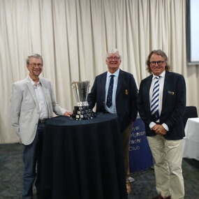 Royal Brighton Yacht Club
Award - 150 Year Celebration Cup
... Keith’s wife Judith was elected to the club membership in 1981and acted as Treasurer for the Ladies Auxiliary for 35 + Years, both contributing to its growth and success through their unwavering support and dedication. ...Keith’s wife Judith was elected to the club membership in 1981and acted as Treasurer for the Ladies Auxiliary for 35 + Years, both contributing to its growth and success through their unwavering support and dedication. ...The Celebration Cup perpetual trophy was presented by Rod and David McKenna at the March Half Yearly General Meeting. Rod addressed the meeting, acknowledging that from its humble beginnings in 1875, the Royal Brighton Yacht Club has been a beacon of excellence in the yachting community. Over the past century and a half, it has grown not only in size and stature but also in the hearts and minds of countless individuals who have shared in the passion and spirit of sailing. The McKenna Family has over 232 years of total membership between them and have been involved in the Royal Brighton Yacht Club community since 1941 when Keith McKenna was first elected to the club membership and appointed Honorary Treasurer in 1950 for 10 Years. Keith’s wife Judith was elected to the club membership in 1981and acted as Treasurer for the Ladies Auxiliary for 35 + Years, both contributing to its growth and success through their unwavering support and dedication. Each of Rod and David’s grandfathers were also members while Rod and David continue to support the club in Race Management duties. The Cup is first awarded for the 150th Anniversary Regatta held on the weekend of 29, 30 March 2025, with winners of each class and Division honoured with a plaque on the Cup. The Deed of Gift accompanying this trophy allows for future celebratory events to preserve the legacy of our club for future generations. More information about the trophy and the McKenna Family's history with RBYC by clicking on the photo and then the right arrows. -
 Coal Creek Community Park & Museum
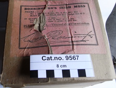
Box, cardboard, 1892 - present in Australia
... Bonnington's Carrageen Irish Moss was first introduced into New Zealand 35 years ago, and it spread gradually until the sales now extend through the whole colony, and has been in constant demand ever since. ...Bonnington's Carrageen Irish Moss was first introduced into New Zealand 35 years ago, and it spread gradually until the sales now extend through the whole colony, and has been in constant demand ever since. ...TROVE : Bendigo Advertiser (Vic. : 1855 - 1918), Saturday 7 September 1901, page 2 BONNINGTON'S IRISH MOSS. Bonnington's Carrageen Irish Moss was first introduced into New Zealand 35 years ago, and it spread gradually until the sales now extend through the whole colony, and has been in constant demand ever since. Through the genuine merits of the widely known and popular remedy for coughs, colds, etc., and encouraged by this success in New Zealand, the proprietor (Mr. Geo. Bonnington) chemist of that colony, was induced to place his celebrated preparation on the Australian market. With that object in view, some eight or ten years ago, a factory for manufacturing purposes was established (under the style of Bonnington and Co.) at 179 Harris-street, Sydney. Since then, its sales have spread far and wide, and the proprietors are pleased to notify the public generally that Bonnington's Carrageen Irish Moss can now be obtained in all the states of Australia. Every year it is becoming more known, and when once tried is always appreciated by the people. Hundreds of testimonials have been received by the proprietors from all parts, testifying to the wonderful curative properties in allaying irritating coughs, bronchitis, colds, and affections of the vocal organs. For the cure of croup, whooping cough, etc., it has proved marvellously successful and is especially prized by mothers for their children, as it never fails to give relief and effect a speedy cure. Containing nothing injurious, there is not the least danger in giving it to children. If they are troubled at night with a hacking cough or any chest affection, one dose will relieve and ensure a good night's rest. The unparalleled which has attended the sale of Bonnington's Carrageen Irish Moss has led to many worthless imitations, and the public when purchasing are cautioned to be sure and ask for Bonnington's. TROVE : Gippsland Times (Vic. : 1861 - 1954), Thursday 1 October 1908, page 3 BONNINGTON'S IRISH MOSS Can be had from any chemist or store. It is the universal remedy for Influenza, Coughs and Colds. A safe and pleasant medicine for children as well as adults. Brown cardboard box with dark blue printed text on side and pink label with black text on top. Contains seven (7) unopened and one (1) opened tall grey boxes with printed white red and black labels. Each grey box containing a cork stoppered rectangular amber glass bottle, with a red, black and white printed label. Each bottle filled with a dark liquid.Outer square cardboard box in dark blue printed text within a decorative border : ' ONE DOZEN BONNINGTON'S Irish Moss for CUGHS, COLDS, INFLUENZA etc'. Pink label sealing paper on top of outer brown cardboard box with black printed text : 'BONNINGTON'S IRISH MOSS PRICES:- No.1 size 36/6 doz. No. 2 size 56/- doz. Retail Price :- Small size 3/6 Large size 6/3. IN QUANTITY Individual packaging boxes containing bottles : Paper labels on each bottle : Embossed on side of bottles in recessed cartouche ' BONNINGTON'S IRISH MOSS COUGHS & COLDS'. Embossed on base of bottles AGM logo and 'IS 804' (4 inverted) over '6'. croup, carrageen, coughs, influenza -
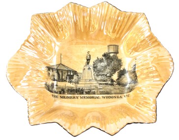 Wodonga & District Historical Society Inc
Memorabilia - Woodland Grove Souvenir dish c1920, RKG, c. 1921 - 1938
... John Woodland, secretary of the Wodonga Shire Council for 35 years, after whom the area was named. The rotunda has since been moved to Martin Park, Wodonga. ...John Woodland, secretary of the Wodonga Shire Council for 35 years, after whom the area was named. The rotunda has since been moved to Martin Park, Wodonga. ...A wide range of souvenirs have been produced to commemorate Wodonga and its landmarks over time. These items document key changes in Wodonga and its heritage. The producers mark on the plate was used by the company RKG Czechoslovakia between 1921 and 1938 This plate depicts three key landmarks in Wodonga. THE SOLDIERS' MEMORIAL in Wodonga was unveiled on Tuesday 18th November 1924. It was designed by Messrs. Hosken & Co., of Hawthorn, Victoria. The monument is all of Australian workmanship. The pedestal is made of Harcourt granite, 9ft x 9ft at the base, and rising in seven courses to a height of 10ft 2in. The emblems (rising sun and wreath) are of bronze, and the lettering of the inscription and names of fallen soldiers are in raised lead letters. Originally the Memorial was completed with a full life size, 6ft in height, sculpture of an Australian soldier in Sicilian marble. The memorial bore the inscriptions: ERECTED BY THE RESIDENTS OF WODONGA AND DISTRICT IN MEMORY of the Men of this Town and District who fell in the Great War, 1914-1919, Also in grateful recognition of the men who served and returned. “Lest We Forget.” In 1982, due to frequent vandalism and high cost of materials to repair, the soldier statue was removed and later installed at the RSL Rooms. THE WATER TOWER is a major landmark of High Street, Wodonga. It began operation from 1924 until it ceased operation in 1959. It stood unused for a decade until the lower section was modified and put to use as “ The Tower’s Cobbler’s Inn” in 1962. In 1972 Wodonga City Council proposed to demolish the Tower. Their suggestion received an unfavorable response from the city’s citizens, so the Tower still stands today. THE BAND ROTUNDA was officially opened on Sunday 5th September 1920 at the naming of the triangular reserve at the corner of High and Hovell Streets as Woodland Grove. The Wodonga Band gave a public performance on this occasion. The tri-coloured ribbon, which stretched across the entrance to the Rotunda was cut by Mrs R.H Murphy, daughter of Mr. John Woodland, secretary of the Wodonga Shire Council for 35 years, after whom the area was named. The rotunda has since been moved to Martin Park, Wodonga. Small china pieces carrying scenic views of holiday destinations were a popular kind of souvenir during much of the 20th century. These items have local and social significance as they reflect the landmarks or local features valued by the community over time. An apricot irregular shaped dish made from lustre ware with a drawing of the Wodonga Soldiers Memorial, Water Tower and Rotunda. The manufacturer's mark is imprinted on the base. Text under the image says 'THE SOLDIERS' MEMORIAL. WODONGA. VICManufacturer's trademark printed on base, in orange paint, in a circular formation 'ROYAL SYDNEY CHINA / MADE IN / CZECHOSLOVAKIA', within circular formation '(crown) / RK / G' ('RK / G' within circle with handles).porcelain, wodonga, royal sydney china, soldier memorial, wodonga souvenirs -
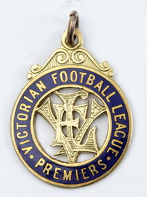 Geelong Football Club
1931 Geelong Football Club Premiership Medallion George Moloney
... Total Brownlow Medal votes: 33 Premiership team selection: 1931 Runner-up in Brownlow Medal count: 1932 (equal) Club Best & Fairest: 1932 Club leading goalscorer: 1931 (74 gls), 1932 (109 gls), 1933 (68 gls) Competition leading goalscorer: 1932 (109) Instances of seven goals or more in a match: 12 Australian Football Hall of Fame inductee GFC Hall of Fame inductee (2002) GFC Life Membership (2012) Career span: 1931-35 Total matches: Premiership 88 Interstate 1 Total goals: Premiership 303, Interstate 3 Finals matches: 7 Finals goals: 15 Last senior match: Round 17, 1935 v Hawthorn at Corio Oval Died: 05/01/1983 Information provided by Mr Col Hutchinson GFC Historian...Total Brownlow Medal votes: 33 Premiership team selection: 1931 Runner-up in Brownlow Medal count: 1932 (equal) Club Best & Fairest: 1932 Club leading goalscorer: 1931 (74 gls), 1932 (109 gls), 1933 (68 gls) Competition leading goalscorer: 1932 (109) Instances of seven goals or more in a match: 12 Australian Football Hall of Fame inductee GFC Hall of Fame inductee (2002) GFC Life Membership (2012) Career span: 1931-35 Total matches: Premiership 88 Interstate 1 Total goals: Premiership 303, Interstate 3 Finals matches: 7 Finals goals: 15 Last senior match: Round 17, 1935 v Hawthorn at Corio Oval Died: 05/01/1983 Information provided by Mr Col Hutchinson GFC Historian GFC 1931 Premiership Grand Final Medal George Moloney Back of medallion has engraving Geelong F.C 1931 George Moloney Geelong F.C. ...George ‘Speca’ Moloney Born: 07/08/1909 From: Claremont-Cottesloe (WA) Height: 174cm Weight: 73kg Natural kicking foot: Right Guernsey number: 14 First senior match: Round 1, 1931 v Collingwood at Victoria Park The remarkably effective full-forward created an impact in his relatively short career. Although quite short for a key position, he was able to produce spectacular results frequently. He possessed remarkable ground play, elusiveness and goal sense. Amazingly, he was able to snap goals with either foot from virtually anywhere within range. Many of his goals came from kicks over his head or shoulder as he ran away from the scoring area to dodge opponents. He was fast, clever and a good mark. His League career commenced spectacularly; in his first two matches he scored a total of 19 goals. He later became the first player in history to score 10 goals or more in two successive matches (Round 15 and 16, 1932). In that year he became the first Geelong player to score 100 goals in a season. During 1935 he played successfully in the centre. Total Brownlow Medal votes: 33 Premiership team selection: 1931 Runner-up in Brownlow Medal count: 1932 (equal) Club Best & Fairest: 1932 Club leading goalscorer: 1931 (74 gls), 1932 (109 gls), 1933 (68 gls) Competition leading goalscorer: 1932 (109) Instances of seven goals or more in a match: 12 Australian Football Hall of Fame inductee GFC Hall of Fame inductee (2002) GFC Life Membership (2012) Career span: 1931-35 Total matches: Premiership 88 Interstate 1 Total goals: Premiership 303, Interstate 3 Finals matches: 7 Finals goals: 15 Last senior match: Round 17, 1935 v Hawthorn at Corio Oval Died: 05/01/1983 Information provided by Mr Col Hutchinson GFC HistorianGeelong F.C. GFC 1931 Victorian Football League Premiers Medallion Gold with blue enamel. Circular shape with VFL in the centre. Back of medallion has engraving Geelong F.C 1931 George MoloneyBack of medallion has engraving Geelong F.C 1931 George Moloneygfc, 1931 premiership, grand final, medal, george moloney -
 Kiewa Valley Historical Society
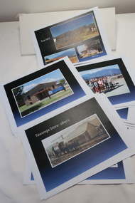
Coloured photographs on paper - Back to Tawonga 2010
... Motor Khana held at Recreation reserve 35. 1970 State Champioships Team 36. Kiewa Valley School Sports at Dederang 37. ...Motor Khana held at Recreation reserve 35. 1970 State Champioships Team 36. Kiewa Valley School Sports at Dederang 37. ...These photos were collected and copied by Di Edmondson for the 'Back To Tawonga' Event in 2010 when she launched her book "Tawonga Remembers".An historical photographic collection of Tawonga and its surrounds, places and people up to 20101. Saw Mill - Mill house 2. The Rock Pool 3. People at the Rock Pool x 2 4.Old Saw mill 5. Back to Tawonga Celebrations x6 6. Tennis Curts opposite the Tawonga Store, Bakery in the background 7. Bowling Club 8. Old Guide Hall 9. The Old Boarding House 10. Old Fire Brigade Shed 11. Building the New Tawonga Memorial Hall 12. Tawonga Go Kart Track - 1960s 13. Tawonga Pony Club 1969 State Championships 14. Tawonga Recreation Reserve Newspaper article 15. The Damm Children 19. 1980s Brian Edmondson, Geoff Edmondson, Mick Harvey, David Piera. Geoff Edmondson's car 20. Tawonga Speedway Track - 1970s Mick Harvey and Paul Harkin's car 21. 2000 22. Tawonga Sports Vera Ryder and Allie Briggs 23. Tawonga School Photos x8 24. Harry Cooper's Farm Looking South 25.View from Edmondson's Farm - looking north 26. Mount Emu 27. St Aiden's Debutante Ball 27. Grand Opening Ball 1961 Tawonga Hall 28. The Kiewa Valley Road at Tawonga. Vic. 29. Tennis Courts opposite the Bogong Hotel 30.Opening of the new Toilet Block in Pioneer park 31. Old Tawonga Store x 3 32. Tawonga Memorial Hall 33. Anglican Church, St Aiden's x 2 34. Motor Khana held at Recreation reserve 35. 1970 State Champioships Team 36. Kiewa Valley School Sports at Dederang 37. Miscellaneous photos x27 Some photos have headings and some headings have been writtentawonga remembers, back to tawonga 2010, di edmondson -
 Bendigo Historical Society Inc.
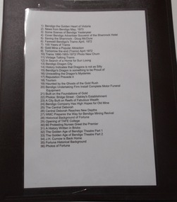
Newspaper - NEWSPAPER COLLECTION: BENDIGO ADVERTISER VARIOUS ARTICLES
... Curnow is Back Home 35) Fortuna Historical Background 36) Photos of Fortuna. ...Curnow is Back Home 35) Fortuna Historical Background 36) Photos of Fortuna. ...1) Bendigo the Golden Heart of Victoria 2) News from Bendigo May, 1973 3) Some Scenes of Bendigo Yesteryear 4) Cover Bendigo Advertiser Souvenir of the Shamrock Hotel 5) Saving the Shamrock - Doug McClure 6) Farewell Bendigo's Trams April, 1972 7) 100 Years of Trams 8) Gold Mine a Popular Attraction 9) Tomorrow the end (Trams) April 1972 10) Trams 1890-1903-1972/ Photo New Chum 11) Vintage Talking Trams 12) In Search of a Home for Sun Loong 13) Bendigo Dragon City 14) History Indicates that Dragons is not as Silly 15) Bendigo's Dragon is Something to be Proud of 16) Unravelling the Dragon's Mysteries 17) Reputation Precede it 18) Tourism 19) Haunted by the Ghosts of the Gold Rush 20) Bendigo Undertaking Firm Installs Complete Motor Funeral Equipment 21) Built on the Foundations of Gold 22) Photos: Bridge Street - Oakley's Establishment 23) A City Built on reefs of Fabulous Wealth 24) Bendigo Company Has High Hopes for Old Mine 25) The Central Deborah 26) Central Deborah Reaches New Depths 27) WMC Prepares the Way for Bendigo Mining Revival 28) Historical Background of Fortuna 29) Opening of TAFE College 30) 60 Protesting Nurses Greet the Premier 31) A History Written in Bricks 32) The Golden Age of Bendigo Theatre Part 1 33) The Golden Age of Bendigo Theatre Part 2 34) J.H. Curnow is Back Home 35) Fortuna Historical Background 36) Photos of Fortuna. Folder 110 now in Box 417. AV 03/11/2022bendigo, goldfields, tourism, history -
 Ringwood and District Historical Society
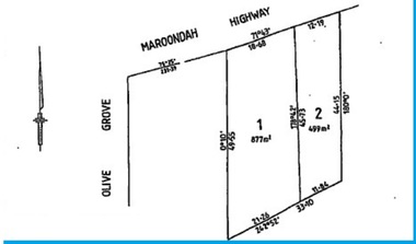
Document - Folder, Landata Certificates - Part of Crown Portion Six, (Lots 1-4 and numbers 70-90) Maroondah Highway, Parish of Ringwood, Victoria
... Building Aust P/L, Lot 1 of subidivision 35788, Whitehorse Road Ringwood, Maliblue P/L 33-35 Ruthven Way Ringwood East, Hesketh Motor Cycles P/L, 70 Maroondah Highway Ringwood, Arthur Clifton Beilby of Ringwood, Storekeeper, Florence Beatrice McGoldrick and Oscar Edward John McGoldrick of "Carrum", Whitehorse Road Ringwood, Elsie May McGoldrick, 82 Whitehorse Road Ringwood, Douglas Murray and Ronald Arthur Mason, H.W.P Tortice and D.M. ...Building Aust P/L, Lot 1 of subidivision 35788, Whitehorse Road Ringwood, Maliblue P/L 33-35 Ruthven Way Ringwood East, Hesketh Motor Cycles P/L, 70 Maroondah Highway Ringwood, Arthur Clifton Beilby of Ringwood, Storekeeper, Florence Beatrice McGoldrick and Oscar Edward John McGoldrick of "Carrum", Whitehorse Road Ringwood, Elsie May McGoldrick, 82 Whitehorse Road Ringwood, Douglas Murray and Ronald Arthur Mason, H.W.P Tortice and D.M. ...27 A4 pages of colour photocopied certificates with typewritten summaries, including Certificate of Title Vol 1156 Fol 231096, 8th March 1880. Certificate of Title Vol 1440 Fol 930, 14th March 1883. Certificate of Title Vol 8487 Fol 090, 28th January 1964. Certificate of Title Vol 9019 Fol 634, 5th December 1973. Certificate of Title Vol 3711 Fol 742129, William John Harnwell, 1st August 1913. Certificate ot Title Vol 6552 Fol 1310305, 5th June 1942. Certificate of Title Vol 5282 Fol 1056207, Arthur Clifton Beilby, 19th July 1927. Certificate of Title Vol 6573 Fol 1314497, Florence Beatrice McGoldrick, Lot 4 on Subdivision 14786, Whitehorse Road, Ringwood, 18th August 1942. Proprietors and transferees include: William Astley of Richmond, Compositor, Marianne Thomson of Jolimont, Spinster, Margaret McGillivray of Ringwood, Spinster, George Frederick Burgess Wilsmore of Ringwood, Railway Employee, Leslie Wilsmore, John Wilsmore, Lionel Wilsmore, 90 Whitehorse Road Ringwood, B.T. Building Aust P/L, Lot 1 of subidivision 35788, Whitehorse Road Ringwood, Maliblue P/L 33-35 Ruthven Way Ringwood East, Hesketh Motor Cycles P/L, 70 Maroondah Highway Ringwood, Arthur Clifton Beilby of Ringwood, Storekeeper, Florence Beatrice McGoldrick and Oscar Edward John McGoldrick of "Carrum", Whitehorse Road Ringwood, Elsie May McGoldrick, 82 Whitehorse Road Ringwood, Douglas Murray and Ronald Arthur Mason, H.W.P Tortice and D.M. Tortice, V.B. Rowe. -
 Melbourne Tram Museum
Ephemera - Exercise Book, The Reading Universal, "Tickets", 1950's to 1980's
... Pages 1 to 13 - MMTB imperial, dual and decimal currency tram and bus tickers, including a Munitions workers fare concession certificate, Scholars Concession ticket, swimming, Adelaide. 14 - 15 - SEC and Brisbane tickets 16 - 17 - MTT Adelaide 18 - 24 - MMTB mixed and some railway card 25 - 26 - Sydney 26 - 28 - Hobart 29 - 30 - Mixed - MOTAT, Ferrymead, Brisbane, Hornibrook Highway Toll, 31 - 32- Melbourne Rail, mixed admission, VR Excess Fare 33 - 34 - SEC 35 - 36 - Dunedin 37 - 38 - Christchurch 39 - 41 - Wellington 42 - Auckland 43 - NZR rail 44 - MMTB 45 - 46 - MTT Adelaide, Tallahassee, St Claude 47 - 48 - Ballarat, Bendigo and TMSV 49 - MMTB 50 - TMSV, SPER 51 - Brisbane 52 - Parramatta Park (COTMA), Eurail pass 53 - Hong Kong, Melbourne rail, platform tickets, pram tickets, Begonia Festival car park, 54 - 55- Mixed - NZR, Wellington, 56 - Auckland 57 - 58 - AETM, Adelaide, 59 - 60 Adelaide, MMTB, Exhibition buildings car park, 61 - Radio receiving licence, mixed bus tricks, Ansett, TAA, 62 - cover - mixed - Ansett, TAA, Ballarat ESCo, Melbourne transport Pageant and MTA/The Met...Pages 1 to 13 - MMTB imperial, dual and decimal currency tram and bus tickers, including a Munitions workers fare concession certificate, Scholars Concession ticket, swimming, Adelaide. 14 - 15 - SEC and Brisbane tickets 16 - 17 - MTT Adelaide 18 - 24 - MMTB mixed and some railway card 25 - 26 - Sydney 26 - 28 - Hobart 29 - 30 - Mixed - MOTAT, Ferrymead, Brisbane, Hornibrook Highway Toll, 31 - 32- Melbourne Rail, mixed admission, VR Excess Fare 33 - 34 - SEC 35 - 36 - Dunedin 37 - 38 - Christchurch 39 - 41 - Wellington 42 - Auckland 43 - NZR rail 44 - MMTB 45 - 46 - MTT Adelaide, Tallahassee, St Claude 47 - 48 - Ballarat, Bendigo and TMSV 49 - MMTB 50 - TMSV, SPER 51 - Brisbane 52 - Parramatta Park (COTMA), Eurail pass 53 - Hong Kong, Melbourne rail, platform tickets, pram tickets, Begonia Festival car park, 54 - 55- Mixed - NZR, Wellington, 56 - Auckland 57 - 58 - AETM, Adelaide, 59 - 60 Adelaide, MMTB, Exhibition buildings car park, 61 - Radio receiving licence, mixed bus tricks, Ansett, TAA, 62 - cover - mixed - Ansett, TAA, Ballarat ESCo, Melbourne transport Pageant and MTA/The Met "Tickets" Ephemera Exercise Book The Reading Universal ...Exercise or Mapping book - The Reding Universal Mapping book, blue front cover plain paper, holding tickets collected by Keith Stodden. Titled "Tickets". Tickets have been positioned using stamp hinges. Pages 1 to 13 - MMTB imperial, dual and decimal currency tram and bus tickers, including a Munitions workers fare concession certificate, Scholars Concession ticket, swimming, Adelaide. 14 - 15 - SEC and Brisbane tickets 16 - 17 - MTT Adelaide 18 - 24 - MMTB mixed and some railway card 25 - 26 - Sydney 26 - 28 - Hobart 29 - 30 - Mixed - MOTAT, Ferrymead, Brisbane, Hornibrook Highway Toll, 31 - 32- Melbourne Rail, mixed admission, VR Excess Fare 33 - 34 - SEC 35 - 36 - Dunedin 37 - 38 - Christchurch 39 - 41 - Wellington 42 - Auckland 43 - NZR rail 44 - MMTB 45 - 46 - MTT Adelaide, Tallahassee, St Claude 47 - 48 - Ballarat, Bendigo and TMSV 49 - MMTB 50 - TMSV, SPER 51 - Brisbane 52 - Parramatta Park (COTMA), Eurail pass 53 - Hong Kong, Melbourne rail, platform tickets, pram tickets, Begonia Festival car park, 54 - 55- Mixed - NZR, Wellington, 56 - Auckland 57 - 58 - AETM, Adelaide, 59 - 60 Adelaide, MMTB, Exhibition buildings car park, 61 - Radio receiving licence, mixed bus tricks, Ansett, TAA, 62 - cover - mixed - Ansett, TAA, Ballarat ESCo, Melbourne transport Pageant and MTA/The Mettrams, tramways, tickets, the met, mmtb, adelaide, sec, tmsv, sydney, buses -
 University of Melbourne, Burnley Campus Archives
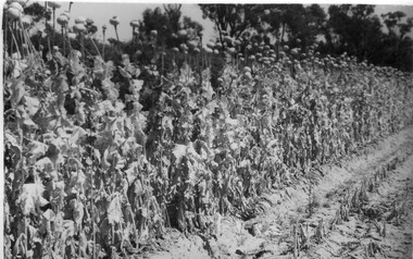
Album - Black and white prints and negatives, James Leslie Provan, Photograph Collection, 1940-1950
... (22) Student hoeing. (23) Student hoeing. (24) Similar. (26) "Cabbage Burbees Allhead 2/2/43," seedlings. (27) Water, manure, etc. (28) "Celery beds Ray Marriott Moorabbin April 2nd 1943." (29-37) Also at Moorabbin probably: (29) Vegetables. (30) Onions. (31) Vegetables. (32) Planting seedlings. (33) Vegetables. (34) Celery, carrots, turnips on display. (35) Carrots growing and just pulled up. (36) Peas. (37) Ploughing with horse. (38) Student spraying vegetables at Burnley. (39) House?...(22) Student hoeing. (23) Student hoeing. (24) Similar. (26) "Cabbage Burbees Allhead 2/2/43," seedlings. (27) Water, manure, etc. (28) "Celery beds Ray Marriott Moorabbin April 2nd 1943." (29-37) Also at Moorabbin probably: (29) Vegetables. (30) Onions. (31) Vegetables. (32) Planting seedlings. (33) Vegetables. (34) Celery, carrots, turnips on display. (35) Carrots growing and just pulled up. (36) Peas. (37) Ploughing with horse. (38) Student spraying vegetables at Burnley. (39) House? ...Collection of 39 black and white photographs. Some photographs with handwritten annotations in what looks like the handwriting of J.L. Provan. Mostly at Burnley, some at Moorabbin. (1) "Opium Poppy 1942 Burnley. Publicity Branch Department of Agriculture." Negative in envelope marked, "Prints 1 of No. 398 Department of Agriculture 'McP.' " (2) Grape vine and cabbages. (3) Rows of seedlings in the Orchard. (4) Orange tree? unpruned. (5) Flowers. (6) "Double and single rows of French Beans." (7) "Sage & marjoram." (8) Hydrangeas. (9)Sprinkler on newly planted cabbages. (10a)"Lettuce Iceberg 1/1/43." Seeds on soil surface. (10b) "Lettuce Iceberg 1/1/43." Seedlings emerging. (11)? planted in terracotta pipes. (12) Rows of seedlings in the Orchard. (13) "A student sowing Parsnip seed in a drill row. School of Horticulture Burnley Gardens." (14) Student distributing fertilizer? (15) Similar. (16) Similar. (17a) Flowers. (17b) Flowers. (18)"Beetroot Crimson Globe." (19) A seed drill. (20)Canna. (21a) Vegetable rows. (21b) ? (22) Student hoeing. (23) Student hoeing. (24) Similar. (26) "Cabbage Burbees Allhead 2/2/43," seedlings. (27) Water, manure, etc. (28) "Celery beds Ray Marriott Moorabbin April 2nd 1943." (29-37) Also at Moorabbin probably: (29) Vegetables. (30) Onions. (31) Vegetables. (32) Planting seedlings. (33) Vegetables. (34) Celery, carrots, turnips on display. (35) Carrots growing and just pulled up. (36) Peas. (37) Ploughing with horse. (38) Student spraying vegetables at Burnley. (39) House?j.l. provan, burnley, moorabbin, opium poppy, grape vine, cabbages, seedlings, orchards, orange trees, flowers, french beans, sage, marjoram, hydrangea, sprinkler, lettuce iceberg, seeds, students sowing, parsnips, school of horticulture burnley gardens, beetroot, hoeing, water, manure, celery, vegetables beds, ray marriott, onions, carrots, turnips, peas, ploughing, horse, spraying -
 University of Melbourne, Burnley Campus Archives
Photograph - Black and white and colour prints, Information Branch Victorian Department of Agriculture, Staff, 1981-1984
... Black and white and colour ID photogeraphs of Staff: (3) Lucy Connop (4) Wendy Jones (8) John Billing (15) Margaret Fogarty (16 Megan Donald (17) John Philp (18) Jenny Leereveld (19) Sue Berkeley (20) Mark Hagell (28) Philip Moyle (29) Danny Cotter (30) Gabrielle Vivian-Smith (31) Sally Williams (32) Stuart Portbury (33) Phil Tulk (34) Jeremy Wallace (35) Veneta Grivas (36) Patrick Howden (37) Marion Hill (38) Jayne Lindholm (39) Marian Verhooght (40) Cathy Morley (42) Russell Benallack (43) Paul Rebeschini (44) Jim Pleasance (45) Jim Wood (46) Peter Rumble (47) Jolyon Burnett (48) Lynn M. ...University of Melbourne, Burnley Campus Archives 500 Yarra Boulevard Richmond melbourne staff lucy connop wendy jones john billing margaret fogarty megan donald john philp jenny leereveld sue berkeley mark hagell philip moyle danny cotter gabrielle vivian-smith sally williams stuart portbury phil tulk jeremy wallace veneta grivas patrick howden marion hill jayne lindholm marian verhooght cathy morley russell benallack paul rebeschini jim pleasance jim wood peter rumble jolyon burnett lynn m. burnett paul a. elliot ivo dean maria malzone hans frederic anthony w. meagher john w. patrick john l. patience geoff olive robert m. hardie daryl jowett dirk van velzen pamela tumath darryl cubbs fred helregal open day graduation tree planting vcah peter oppenheimer Black and white and colour ID photogeraphs of Staff: (3) Lucy Connop (4) Wendy Jones (8) John Billing (15) Margaret Fogarty (16 Megan Donald (17) John Philp (18) Jenny Leereveld (19) Sue Berkeley (20) Mark Hagell (28) Philip Moyle (29) Danny Cotter (30) Gabrielle Vivian-Smith (31) Sally Williams (32) Stuart Portbury (33) Phil Tulk (34) Jeremy Wallace (35) Veneta Grivas (36) Patrick Howden (37) Marion Hill (38) Jayne Lindholm (39) Marian Verhooght (40) Cathy Morley (42) Russell Benallack (43) Paul Rebeschini (44) Jim Pleasance (45) Jim Wood (46) Peter Rumble (47) Jolyon Burnett (48) Lynn M. ...Black and white and colour ID photogeraphs of Staff: (3) Lucy Connop (4) Wendy Jones (8) John Billing (15) Margaret Fogarty (16 Megan Donald (17) John Philp (18) Jenny Leereveld (19) Sue Berkeley (20) Mark Hagell (28) Philip Moyle (29) Danny Cotter (30) Gabrielle Vivian-Smith (31) Sally Williams (32) Stuart Portbury (33) Phil Tulk (34) Jeremy Wallace (35) Veneta Grivas (36) Patrick Howden (37) Marion Hill (38) Jayne Lindholm (39) Marian Verhooght (40) Cathy Morley (42) Russell Benallack (43) Paul Rebeschini (44) Jim Pleasance (45) Jim Wood (46) Peter Rumble (47) Jolyon Burnett (48) Lynn M. Burnett (49) Paul A. Elliot (50) Ivo Dean (51) Maria Malzone (52) Hans Frederic (53) Anthony W. Meagher (54 John W. Patrick (56) John L. Patience (61) Geoff Olive (62) Robert M. Hardie (63) Daryl Jowett (64) Dirk van Velzen ((66) Pamela Tumath (69) Darryl Cubbs (70) Jim Pleasance (81) Fred Helregal 01.0801984 (82) Staff group (83) V.C.A.H. Burnley Open day Staff at a stand (84) Graduation group (85) Graduation speaker (86) Graduation-tree planting (89-92) VCAH stamp 2/84 (95) VCAH stamp 2/84 (96) Peter Oppenheimer and student 1981 Dept of Agriculture stamp.staff, lucy connop, wendy jones, john billing, margaret fogarty, megan donald, john philp, jenny leereveld, sue berkeley, mark hagell, philip moyle, danny cotter, gabrielle vivian-smith, sally williams, stuart portbury, phil tulk, jeremy wallace, veneta grivas, patrick howden, marion hill, jayne lindholm, marian verhooght, cathy morley, russell benallack, paul rebeschini, jim pleasance, jim wood, peter rumble, jolyon burnett, lynn m. burnett, paul a. elliot, ivo dean, maria malzone, hans frederic, anthony w. meagher, john w. patrick, john l. patience, geoff olive, robert m. hardie, daryl jowett, dirk van velzen, pamela tumath, darryl cubbs, fred helregal, open day, graduation, tree planting, vcah, peter oppenheimer -
 Melbourne Tram Museum
Document - Report, Ministry of Transport, Geelong Steam Preservation Society, "Victorian Transport Study - (The Lonie Report)", 1980
... Comprises: .1 - Final Report - 174 pages .2 - Background to Transport Finance - white comb bound - 192 pages .3 - Summary of Submissions - fawn colour comb bound - 70 pages .4 - Background to State Development - 94 pages .5 - Land transport in Victoria - Historical background - white comb bound - 31 pages .6 - Bicycles - 19 pages .7 - Car pooling - 15 pages .8 - VicRail Financial system - 35 pages .9 - Transport of Fertilisers - 17 pages .10 - Staggered working hours - white comb bound - 16 pages .11 - Administration of Transport - 79 pages .12 - Metropolitan Roads - 60 pages .13 - Transport of Students - 24 pages .14 - Fuel for transport - unbound - stapled in top corner - photocopy of a bound document - 42 pages. ...Comprises: .1 - Final Report - 174 pages .2 - Background to Transport Finance - white comb bound - 192 pages .3 - Summary of Submissions - fawn colour comb bound - 70 pages .4 - Background to State Development - 94 pages .5 - Land transport in Victoria - Historical background - white comb bound - 31 pages .6 - Bicycles - 19 pages .7 - Car pooling - 15 pages .8 - VicRail Financial system - 35 pages .9 - Transport of Fertilisers - 17 pages .10 - Staggered working hours - white comb bound - 16 pages .11 - Administration of Transport - 79 pages .12 - Metropolitan Roads - 60 pages .13 - Transport of Students - 24 pages .14 - Fuel for transport - unbound - stapled in top corner - photocopy of a bound document - 42 pages. ...Set of reports, known as the "Victorian Transport Study - (The Lonie Report)", produced during 1980 and supplementary reports. Prepared from Robert Maclellan Minister of Transport by W. M Lonie. Documents resulted in significant change to the Victorian transport structures, especially the way freight and railway transport was handled. see http://en.wikipedia.org/wiki/Lonie_Report (accessed 25-9-2014) Documents generally perfect bound into manila coloured covers - unless noted otherwise. Comprises: .1 - Final Report - 174 pages .2 - Background to Transport Finance - white comb bound - 192 pages .3 - Summary of Submissions - fawn colour comb bound - 70 pages .4 - Background to State Development - 94 pages .5 - Land transport in Victoria - Historical background - white comb bound - 31 pages .6 - Bicycles - 19 pages .7 - Car pooling - 15 pages .8 - VicRail Financial system - 35 pages .9 - Transport of Fertilisers - 17 pages .10 - Staggered working hours - white comb bound - 16 pages .11 - Administration of Transport - 79 pages .12 - Metropolitan Roads - 60 pages .13 - Transport of Students - 24 pages .14 - Fuel for transport - unbound - stapled in top corner - photocopy of a bound document - 42 pages. This set does not comprise the full set of reports produced - see final document. .15 Autum 2016 issue of the Geelong Steam Preservation Society (Bellarine Railway) which contains an article on the Lonie Report "From Rags to Riches (Part 1). - See images 620a, 620b and 620c. The Winter issue did not have any materials on tramways.trams, tramways, transport, victoria, lonie report, railways, melbourne, tramways -
 Melbourne Tram Museum
Album - Photo Album, Michael Schrader, "Tram Pix ex Slides", 1960's
... ... tram 35...Sheet 1 front: MMTB Christmas Tram - 16W - Swanston St - 1963 T181 at Footscray Depot c1960 Brisbane Dreadnought 178 Sheet 1 rear VR 6 on an AETA Tour Brighton line Brisbane 358 and baby dreadnought and a group of 4 people Ballarat 35 and three other trams in City Loop - pre 1960 Sheet 2 front Ballarat 30 in bound in Albert St Sebastopol pre 1960 Bendigo 12 leaving depot, pre 1960 Bendigo 26 at Eaglehawk pre 1960 Sheet 2 rear Bendigo 29 pre 1960 Bendigo 28 with a group of enthusiasts standing in front - mid to late 1960's Sydney - coupled set of crossbench cars at a beach terminus Sheet 3 front Sydney - with Mark Foys in background Sydney - 2057 Sydney - trams being scrapped c1960 Sheet 3 rear Sydney - trams being burnt VR 30 at St Kilda Station Sheet 4 front VR36 and 6 on the Brighton line VR53 at St Kilda Station Sheet 4 rear VR 51 at Sandringham VR 51 on Sandringham Black Rock line VR 50 at Black Rock terminus Sheet 5 - not used Sheet 6 - front - photograph of a steam tram locomotive???...Melbourne Tram Museum 8 Wallen Road Hawthorn melbourne Trams tramways Swanston St Myer Christmas Trams Footscray Depot Brisbane St Kilda Brighton Ballarat Bendigo Sydney Scrapped Trams St Kilda Railway Station Sandringham Black Rock tram 16W tram 181 tram 178 tram 6 tram 358 tram 35 tram 30 tram 12 tram 26 tram 29 tram 28 tram 2057 tram 30 tram 36 tram 53 tram 51 tram 50 Manilla file folder, Railways of Australia Committee with a blue tape on the left hand side, preprinted file containing six sets of photograph sleeves with a sheet of white paper between, marked "Tram Pix ex Slides". ...Manilla file folder, Railways of Australia Committee with a blue tape on the left hand side, preprinted file containing six sets of photograph sleeves with a sheet of white paper between, marked "Tram Pix ex Slides". Clipped into the folder with brass foldback clips. Sheet 1 front: MMTB Christmas Tram - 16W - Swanston St - 1963 T181 at Footscray Depot c1960 Brisbane Dreadnought 178 Sheet 1 rear VR 6 on an AETA Tour Brighton line Brisbane 358 and baby dreadnought and a group of 4 people Ballarat 35 and three other trams in City Loop - pre 1960 Sheet 2 front Ballarat 30 in bound in Albert St Sebastopol pre 1960 Bendigo 12 leaving depot, pre 1960 Bendigo 26 at Eaglehawk pre 1960 Sheet 2 rear Bendigo 29 pre 1960 Bendigo 28 with a group of enthusiasts standing in front - mid to late 1960's Sydney - coupled set of crossbench cars at a beach terminus Sheet 3 front Sydney - with Mark Foys in background Sydney - 2057 Sydney - trams being scrapped c1960 Sheet 3 rear Sydney - trams being burnt VR 30 at St Kilda Station Sheet 4 front VR36 and 6 on the Brighton line VR53 at St Kilda Station Sheet 4 rear VR 51 at Sandringham VR 51 on Sandringham Black Rock line VR 50 at Black Rock terminus Sheet 5 - not used Sheet 6 - front - photograph of a steam tram locomotive???trams, tramways, swanston st, myer, christmas trams, footscray depot, brisbane, st kilda brighton, ballarat, bendigo, sydney, scrapped trams, st kilda railway station, sandringham, black rock, tram 16w, tram 181, tram 178, tram 6, tram 358, tram 35, tram 30, tram 12, tram 26, tram 29, tram 28, tram 2057, tram 30, tram 36, tram 53, tram 51, tram 50 -
 Bendigo Historical Society Inc.
Document - ANCIENT ORDER OF FORESTERS NO. 3770 COLLECTION: NOTE
... He stated that the court opened with 35 members and now numbered about 200. He congratulated the Court on having more members than any other court of the order in the district. ...He stated that the court opened with 35 members and now numbered about 200. He congratulated the Court on having more members than any other court of the order in the district. ...'Bendigo Advertiser, Monday 18th May 1863, p2: ' On the occasion of the first anniversary of Court Sherwood of the Ancient Order of Foresters, a ball was given by the members at the Sir Henry Barkly Hotel, Huntly on Thursday night last. There must have been at least 70 or 80 persons present, many of them from Sandhurst, White Hills, Eaglehawk and etc. Dancing commenced at nine o'clock and was vigorously kept up till the early dawn of another day came to light. Supper was served in the Court Room and the excellent repast provided by the host was duly appreciated .... from casual observation appearances would indicate that on a future day the Foresters would create a Court into which the ladies would be permitted to join in the bonds of fellowship.' Bendigo Advertiser, Thursday 2nd November 1865, p 2: 'The fourth anniversary of the establishment of Court Bendigo of the above order was celebrated on Tuesday evening at the Bendigo Hotel by a supper. There were between forty and fifty members present. The Secretary, in the course of his remarks, referred to the progress which the court had made since its establishment in October 1861. He stated that the court opened with 35 members and now numbered about 200. He congratulated the Court on having more members than any other court of the order in the district. Since it was established there had only occurred one death and at present there was only one sick member declared as receiving aid from the funds. District Secretary Holl, in responding to the toast of prosperity at the Bendigo United District of the Ancient Order of Foresters, stated that the district was first formed in 1862. At the end of the first quarter of 1862, there were eight Courts numbering 479 members. At the end of the last quarter there were twelve Courts, numbering 1278 financial members. The funds of the district in July 1862 amounted to £22/2/2d and in October 1865, the amount had increased to £570/2/8d while the Court funds amounted to £3,330/18/9d. During the last twelve months £893/8/10d had been paid for the benefit of the sick, thus showing the great benefits which were derived by becoming members of the order. Note dated 7 Oct. 1863, Court King of the Forest for P. C. R. Silk Sash £1/1/-. Signed by Jas. Thos. Holl.societies, correspondence, ancient order of foresters no. 3770 collection - note, court king of the forest, jas thos holl -
 Wodonga & District Historical Society Inc
Souvenir - Souvenir Cream Jug - Soldiers' Memorial, Wodonga
... John Woodland, secretary of the Wodonga Shire Council for 35 years, after whom the area was named. The rotunda has since been moved to Martin Park, Wodonga....John Woodland, secretary of the Wodonga Shire Council for 35 years, after whom the area was named. The rotunda has since been moved to Martin Park, Wodonga. ...This item is from a collection donated by descendants of John Francis Turner of Wodonga. A wide range of small china pieces carrying scenic views of holiday destinations or key locations were a popular kind of souvenir during much of the 20th century. Several different items have been produced to commemorate Wodonga and its landmarks over time. These items document key changes in Wodonga and its heritage. This plate depicts three key landmarks in Wodonga. THE SOLDIERS' MEMORIAL in Wodonga was unveiled on Tuesday 18th November 1924. It was designed by Messrs. Hosken & Co., of Hawthorn, Victoria. The monument is all of Australian workmanship. The pedestal is made of Harcourt granite, 9ft x 9ft at the base, and rising in seven courses to a height of 10ft 2in. The emblems (rising sun and wreath) are of bronze, and the lettering of the inscription and names of fallen soldiers are in raised lead letters. Originally the Memorial was completed with a full life size, 6ft in height, sculpture of an Australian soldier in Sicilian marble. The memorial bore the inscriptions: ERECTED BY THE RESIDENTS OF WODONGA AND DISTRICT IN MEMORY of the Men of this Town and District who fell in the Great War, 1914-1919, Also in grateful recognition of the men who served and returned. “Lest We Forget.” In 1982, due to frequent vandalism and high cost of materials to repair, the soldier statue was removed and later installed at the RSL Rooms. THE WATER TOWER is a major landmark of High Street, Wodonga. It began operation from January 1924 until it ceased operation in 1959. It stood unused for a decade until the lower section was modified and put to use as “ The Tower’s Cobbler’s Inn” in 1962. In 1972 Wodonga City Council proposed to demolish the Tower. Their suggestion received an unfavorable response from the city’s citizens, so the Tower still stands today. THE BAND ROTUNDA was officially opened on Sunday 5th September 1920 at the naming of the triangular reserve at the corner of High and Hovell Streets as Woodland Grove. The Wodonga Band gave a public performance on this occasion. The tri-coloured ribbon, which stretched across the entrance to the Rotunda was cut by Mrs R.H Murphy, daughter of Mr. John Woodland, secretary of the Wodonga Shire Council for 35 years, after whom the area was named. The rotunda has since been moved to Martin Park, Wodonga.This item comes from a collection used by a prominent citizen of Wodonga. It is also an excellent example of souvenir items created featuring landmarks to represent the city of Wodonga.White glazed porcelain cream jug with grooved square handle. The base is unglazed. The rim and outer face of the handle are outlined in black paint. On one side of the jug is a black transfer print of a the Wodonga Soldiers' Memorial. Text underneath the scene reads "THE SOLDIERS' MEMORIAL, WODONGA, VIC."'. The manufacturer's trademark is printed on the base of the jug. RKG stood for Rudolf Kampf of Grunlas. The mark with the initials under the crown was used from 1921 to 1938.Beneath the image: 'THE SOLDIERS' MEMORIAL WODONGA VIC" Under the jug Manufacturer's trademark printed in orange paint, in a circular formation '(crown) / RK / G' ('RK / G' within circle with handles) above the words "Made in Czechoslovakia"domestic items, souvenir wodonga, woodland grove wodonga -
 Wodonga & District Historical Society Inc
Souvenir - China Souvenir Plate Soldiers' Memorial. Wodonga, Victoria China, c1924 - 1939
... John Woodland, secretary of the Wodonga Shire Council for 35 years, after whom the area was named. The rotunda has since been moved to Martin Park, Wodonga....John Woodland, secretary of the Wodonga Shire Council for 35 years, after whom the area was named. The rotunda has since been moved to Martin Park, Wodonga. ...This item is from a collection donated by descendants of John Francis Turner of Wodonga. A wide range of small china pieces carrying scenic views of holiday destinations or key locations were a popular kind of souvenir during much of the 20th century. Several different items have been produced to commemorate Wodonga and its landmarks over time. These items document key changes in Wodonga and its heritage. This plate depicts three key landmarks in Wodonga. THE SOLDIERS' MEMORIAL in Wodonga was unveiled on Tuesday 18th November 1924. It was designed by Messrs. Hosken & Co., of Hawthorn, Victoria. The monument is all of Australian workmanship. The pedestal is made of Harcourt granite, 9ft x 9ft at the base, and rising in seven courses to a height of 10ft 2in. The emblems (rising sun and wreath) are of bronze, and the lettering of the inscription and names of fallen soldiers are in raised lead letters. Originally the Memorial was completed with a full life size, 6ft in height, sculpture of an Australian soldier in Sicilian marble. The memorial bore the inscriptions: ERECTED BY THE RESIDENTS OF WODONGA AND DISTRICT IN MEMORY of the Men of this Town and District who fell in the Great War, 1914-1919, Also in grateful recognition of the men who served and returned. “Lest We Forget.” In 1982, due to frequent vandalism and high cost of materials to repair, the soldier statue was removed and later installed at the RSL Rooms. THE WATER TOWER is a major landmark of High Street, Wodonga. It began operation from January 1924 until it ceased operation in 1959. It stood unused for a decade until the lower section was modified and put to use as “ The Tower’s Cobbler’s Inn” in 1962. In 1972 Wodonga City Council proposed to demolish the Tower. Their suggestion received an unfavorable response from the city’s citizens, so the Tower still stands today. THE BAND ROTUNDA was officially opened on Sunday 5th September 1920 at the naming of the triangular reserve at the corner of High and Hovell Streets as Woodland Grove. The Wodonga Band gave a public performance on this occasion. The tri-coloured ribbon, which stretched across the entrance to the Rotunda was cut by Mrs R.H Murphy, daughter of Mr. John Woodland, secretary of the Wodonga Shire Council for 35 years, after whom the area was named. The rotunda has since been moved to Martin Park, Wodonga.This item comes from a collection used by a prominent citizen of Wodonga. It is also an excellent example of souvenir items created featuring landmarks to represent the city of Wodonga.A china plate depicting the Soldiers' Memorial Wodonga. The central coloured image is surrounded by a 8 representations of a variety of flowers and a silver edge trim. The makers mark underneath the dish was used between 1918 - 1939 so assists in establishing provenance of the irem.Beneath image: "SOLDIERS' MEMORIAL WODONGA On back of dish, Beneath a crown " VICTORIA CHINA CZECHOSLAVAKIA"victoria china, souvenir wodonga, wodonga soldiers memorial, woodland grove wodonga