Showing 179035 items
matching streets
-
 Ringwood and District Historical Society
Plan, Ringwood Station Estate, Subdivision, Ringwood, Victoria - circa 1925
ID 5224 note: Further information relating to squares marked H, F, G, J, and K included in ID 5225 - Ringwood Shop and Dwelling Estate.Hand drawn plan of Ringwood Station Estate showing allotments for sale, with two typed pages attached showing land title information and sale prices.Drawn by Edyth Greenwood, phone 988 Central. Subdivision includes Station Street, Pitt Street, Bedford Road, Wantirna Road, James Street, William Street (later Kendall Street), Greenwood Avenue, Ellison Street, and Haig Street. Circles denote blocks for sale. Squares denote house properties for sale. Other features marked include location of businesses along Main Street (Maroondah Highway), cool store, railway station, shop and police station on Bedford Road, church on Station Street, site of schoolmaster's residence and State School, and location of proposed public baths. Ryner & Langford, Solicitors -
 Ballarat Tramway Museum
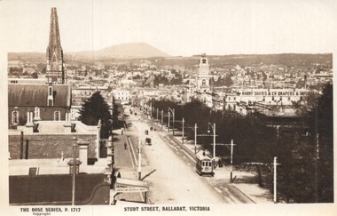
Postcard - Sturt Street Ballarat, Victoria, Rose Stereograph Co, 1920s?
Photo taken from the City Fire Brigade station at the corner of Sturt and Raglan Streets, looking east towards Mount Warrenheip. Has an eastbound ESCo tram. Photo shows the overhead structures, Harry Davies & Co. Drapers Importers, Ballarat Town Hall and the general view of the city. On the rear is a large Rose symbol and publisher details.Yields information about Sturt St during 1920sPostcard - Rose Series P 1717, Sturt Street looking east. Second copy - cigarette card size - 63mm x 87mmHas an address in Macarthur St, Ballarat on rear. Second copy has in ink "To Ken from Paul Kiwi4755"ballarat, sturt st, fire watch tower, harry davies -
 Surrey Hills Historical Society Collection
Work on paper - Photograph, Nethercourt Private Hospital, Surrey Hills, c 1924, 1924
Notes from a previous collection coordinator indicate that Miss Lucy Musselwhite (Lillywhite) opened the hospital in 1914 and Matron Eliza Tank took it over in 1921 and named it Nethercourt Private Hospital. However recent research suggests that Miss Musselwhite (name confirmed) moved from Tooronga to Wilson Street some time between 1903 and 1909. She and her mother Elizabeth are listed in the 1909 electoral rolls in Wilson Street and Lucy's occupation is given as nurse. (It is of course possible that the property was a residence only at this time and later opened as a private hospital.) The name Nethercourt was used prior to Matron Eliza Tank taking over. Her daughter Irene was also a nurse at Nethercourt. Lucy Musselwhite was born in 1873 in Hampshire. She married Henry James Dore in later life and lived in Brenbeal Street, Balwyn. She died in 1955. In 1930 / 1935 Matron Tank transferred the hospital to 219-223 Union Road. Later it was known as Norwich Hall / St Jude's. Mosgiel Hospital in Mont Albert Road also opened in 1924. After this time home births became less common. Nethercourt Hospital closed in the 1960s.Small hospitals such as this one were primarily used for midwifery, preceding the development of larger centralised general hospitals. Black and white photo of Nethercourt Private Hospital at 11 Wilson Street in c 1924 taken from the street in winter. The building is Victorian in style; block-fronted with lacework detail to the verandah and has 2 chimneys. It is set behind a wooden picket fence behind which is a well-manicured hedge which appears to have been grown across the front entrance gate.nethercourt private hospital, midwifery, hospitals, matron eliza tank, miss lucy musselwhite, miss irene tank, mrs irene anderson -
 Kew Historical Society Inc
Plan, Melbourne & Metropolitan Board of Works : Borough of Kew : Detail Plan No.1581, 1904
The Melbourne and Metropolitan Board of Works (MMBW) plans were produced from the 1890s to the 1950s. They were crucial to the design and development of Melbourne's sewerage and drainage system. The plans, at a scale of 40 feet to 1 inch (1:480), provide a detailed historical record of Melbourne streetscapes and environmental features. Each plan covers one or two street blocks (roughly six streets), showing details of buildings, including garden layouts and ownership boundaries, and features such as laneways, drains, bridges, parks, municipal boundaries and other prominent landmarks as they existed at the time each plan was produced. (Source: State Library of Victoria)This plan forms part of a large group of MMBW plans and maps that was donated to the Society by the Mr Poulter, City Engineer of the City of Kew in 1989. Within this collection, thirty-five hand-coloured plans, backed with linen, are of statewide significance as they include annotations that provide details of construction materials used in buildings in the first decade of the 20th century as well as additional information about land ownership and usage. The copies in the Public Record Office Victoria and the State Library of Victoria are monochrome versions which do not denote building materials so that the maps in this collection are invaluable and unique tools for researchers and heritage consultants. A number of the plans are not held in the collection of the State Library of Victoria so they have the additional attribute of rarity.Original survey plan, issued by the MMBW to a contractor with responsibility for constructing sewers in the area identified on the plan within the Borough of Kew. The plan was at some stage hand-coloured, possibly by the contractor, but more likely by officers working in the Engineering Department of the Borough and later Town, then City of Kew. The hand-coloured sections of buildings on the plan were used to denote masonry or brick constructions (pink), weatherboard constructions (yellow), and public buildings (grey). The streets and built structures in this plan were surveyed in 1903 and released to contractors in 1904. In addition to the designation of building types by colour, the plan includes detailed descriptions of land use and ownership. While many buildings remain from this period, a number of the buildings represented have been demolished including the original Kew Town Hall, and the Congregational and Roman Catholic churches in Walpole Street. While the mansion ‘Illapa’ in Princess Street is still extant – now part of ‘Rylands’ – the neighbouring mansion ‘Elsmere’ was demolished some decades ago. Rivalling Illapa and Elsmere in size were two mansions in Walpole Street, one named on the plan as ‘Gnarlbine’. Over time, Kew Junction and the south side of High Street have been reconfigured and widened, so that the commercial buildings on the corner of Princess and High Street no longer exist. A surprising feature of this part of central Kew to the northwest of Kew Junction is the amount of vacant land. In a number of cases, this land is noted by the contractor as used for vegetable gardens.melbourne and metropolitan board of works, detail plans, maps - borough of kew, mmbw 1581, cartography -
 Kew Historical Society Inc
Plan, Melbourne & Metropolitan Board of Works : Borough of Kew : Detail Plan No.1568, 1905
The Melbourne and Metropolitan Board of Works (MMBW) plans were produced from the 1890s to the 1950s. They were crucial to the design and development of Melbourne's sewerage and drainage system. The plans, at a scale of 40 feet to 1 inch (1:480), provide a detailed historical record of Melbourne streetscapes and environmental features. Each plan covers one or two street blocks (roughly six streets), showing details of buildings, including garden layouts and ownership boundaries, and features such as laneways, drains, bridges, parks, municipal boundaries and other prominent landmarks as they existed at the time each plan was produced. (Source: State Library of Victoria)This plan forms part of a large group of MMBW plans and maps that was donated to the Society by the Mr Poulter, City Engineer of the City of Kew in 1989. Within this collection, thirty-five hand-coloured plans, backed with linen, are of statewide significance as they include annotations that provide details of construction materials used in buildings in the first decade of the 20th century as well as additional information about land ownership and usage. The copies in the Public Record Office Victoria and the State Library of Victoria are monochrome versions which do not denote building materials so that the maps in this collection are invaluable and unique tools for researchers and heritage consultants. A number of the plans are not held in the collection of the State Library of Victoria so they have the additional attribute of rarity.Original survey plan, issued by the MMBW to a contractor with responsibility for constructing sewers in the area identified on the plan within the Borough of Kew. The plan was at some stage hand-coloured, possibly by the contractor, but more likely by officers working in the Engineering Department of the Borough and later Town, then City of Kew. The hand-coloured sections of buildings on the plan were used to denote masonry or brick constructions (pink), weatherboard constructions (yellow), and public buildings (grey). Plan No.1568 covers the area bounded by Cotham Road, John Street, Sackville Street, and Edward Street. Alfred Street and Rowland Street are in shown in the middle of the plan. The two most notable buildings shown are ‘St Helliers’, the home of the Dumaresq family, and St Hilary’s Church and school. While the colours used to indicate St Hilary’s are grey as in other civic/public buildings, the first St Hilary’s Anglican Church was at this stage constructed in weatherboard. At the left of the plan, facing Sackville Street is a house named ‘Glencara’. The 1988 ‘Kew Conservation Study’ recorded that “The first documentary evidence of this house comes from Rate Books which record that in 1893 a Mrs Treadway was the owner of this building with an N.A.V. of £81? At that date the occupier of the house was Charles B. Kelly, a clerk, while by 1910 Kelly had become the owner of the property described in that year ‘as a six-roomed stone, brick and wood house with stables and outbuildings’”. Contrary to this description, the 1905 plan indicates that the house was entirely constructed of masonry.melbourne and metropolitan board of works, detail plans, mmbw 1568 -
 Canterbury History Group
Photograph - Garden of "Roquebrune" corner of Canterbury Road and Gascoyne Street Canterbury, c1920
"Roquebrune" built in 1912 or 1914 by G.H.Tarrrant and demolished in 1971 to make way for the Baptist Nursing Home on the corner of Canterbury Road and Gascoyne Street Canterbury. Now apartmentsGarden and side of the house "Roquebrune" built in 1912 or 1914 by G.H.Tarrrant and demolished in 1971 to make way for the Baptist Nursing Home on the corner of Canterbury Road and Gascoyne Street Canterbury. Now apartmentscanterbury, canterbury road, gascoyne street, roquebrune, edwardian style, baptist nursing home, aged people, nursing homes, garden -
 Eltham District Historical Society Inc
Photograph, 1934 Floods at Eltham
Published in the Diamond Creek Basin Study, 1980 and identified at Diamond Creek, locality not identified, 1934. The location is actually looking south across the Diamond Creek towards Falkiner Street, beside the Main Road bridge at Eltham South from what is now part of Wingrove Park opposite Antoinette Boulevard. The bridge railing is just visible to the left of image. The large leaning Manna Gum beside the bridge still stands in 2021 alongside the Diamond Creek trail. In 1934 extensive flooding of the Yarra River and Diamond Creek set new records for flood plain level (Eltham Chronology, EDHS)Black and white photographCopied by Hugh Fisher, Photographer, 6 York Street Eltham A1678B Floods- Eltham - 1934floods, yarra river, eltham, flooding, diamond creek, flood -
 Eltham District Historical Society Inc
Photograph, Believed to be Eltham North, c.1989, 1989c
... streets ...Streetscape evolutionRoll of 35mm colour negative film, 6 stripsFuji 200Ahouses, streets, eltham north -
 Eltham District Historical Society Inc
Photograph, Napoleon Street near Bible Street, Eltham
... streets ...Colour photographstreets, bible street, napoleon street -
 Eltham District Historical Society Inc
Photograph, Wooded Way, Montmorency, c.1990, 1990c
... streets ...Colour positive film medium formatKodak 5006 frames 7 and 12wooded way, montmorency, streets -
 Eltham District Historical Society Inc
Photograph, 523 Main Road, Eltham, c.May 2001
... streets ...Adjacent to Main Road-Fitzsimons Lane roundaboutRoll of 35mm colour negative film, 7 stripsAgfa HDC 200 plus-2eltham, streets, main road -
 Eltham District Historical Society Inc
Photograph, Mountain View Road, Briar Hill
... streets ...Roll of 35mm colour negative film, 4 stripsFuji 100streets, mountain view road, briar hill -
 Tarnagulla History Archive
Photograph of Commercial Road, Tarnagulla, Commercial Road, Tarnagulla, circa 1960s
... streets ...Murray Comrie Collection.Photograph of Commercial Road, Tarnagulla (northern end, looking south). Photo probably taken in the 1960s. tarnagulla, buildings, streets -
 Bendigo Historical Society Inc.
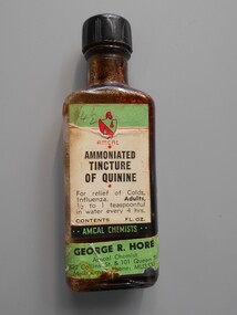
Container - PHARMACY COLLECTION: QUININE BOTTLE, 1940's
Object. Glass bottle with black plastic screw top. Green, white & red paper label, with black print Amcal ammoniated tincture of quinnine for relief of colds, influenza.Amcal Chemists. George R.Hore, 432 Collins Street, & 101 Collins Street Melbourne. Phone MU3535.medicine, first aid, quinnine bottle -
Tatura Irrigation & Wartime Camps Museum
Photograph - original, Free & Son, Frank Busam, 1940 original
Frank Busam grew first stone fruit in Tatura. Photograph given to Museum by Cr. Kevin Walker.Original sepia photograph of Frank Busamon back: Free & Son. Photographic Artists. Eastern Market, Bourke Street, 22 Greville Street Prahan.frank busam -
 Clunes Museum
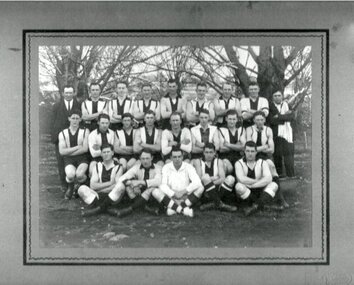
Photograph - PHOTOGRAPH FOOTBALL, 1930
BLACK AND WHITE PHOTOGRAPH OF FOOTBALL TEAM TAKEN AT CLUNES OVAL.On reverse: Mrs. C. Spark 15 Edward Street Footscray, late of Albert Street, North Clunes.photography, photographs, sport, football -
 Stawell Historical Society Inc
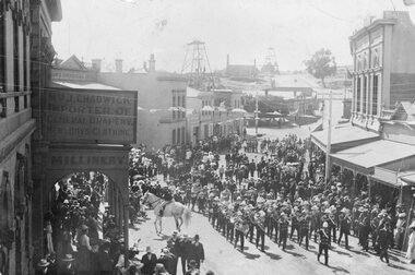
Photograph, Upper Main Street Stawell procession with the band & a police constable on Horseback visible c1901
Main Street Procession East End Circa 1901. Stawell Brass Band plus Constable on Horseback visible. J Chadwick Importer of General Drapery with Boys Clothing on sign on left. Millinery on side of verandah. Commercial Hotel just visible on left. Sloane's & Scotchmans Poppet head Visible in background on right. Poppet Head in background on Big Hill on left is Crown Cross shaft.Croud of people lead by band in upper main street. Chadwick drapers on left. Mounted policeman on horseback in front of Commercial Hotel.stawell businesses streetscape -
 Bendigo Historical Society Inc.
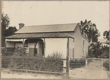
Photograph - T C WATTS & SON COLLECTION: CREEK STREET, BENDIGO, 1930
Herbert Allan Unwin (1898-1958) lived at 171 Creek Street in 1928. In 1924 he had been listed as living at 78 Gladstone Street. After selling the Creek Street property, he moved to 629 Hargreaves Street. Herbert was a labourer who married Caroline Struggell in 1920.Black and white photographs (2) mounted on rectangular brown board. House, weatherboard, corrugated iron roof, curved verandah roof, trellis at ends of verandah, 2 canvas blinds on verandah, woven crinkled wire fence. On back of photo ' Unwin, Creek Street, £420 plus sewer' Date stamp 11 April 1930.Frank A. Jeffree, Bendigobendigo, business, t c watts & son -
 Federation University Historical Collection
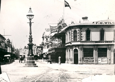
Photograph - Black and White, Bridge Street Ballarat , c1890, c1890
The original of this image is held by the State Library of Victoria.Copy of a black and white photograph of Bridge Street Ballarat from the corner of Grenville Street and Sturt Street. The photo shows a street lamp in the middle of the intersection, fire hydrant, Yeoman's flag, tram tracks, and horse drawn vehicles.bridge street ballarat, sturt street ballarat, grenville street ballarat,, f.b. wilson, buck's head hotel -
Port Melbourne Historical & Preservation Society
Photograph - Albion Hotel, Evans Street, Port Melbourne, Meredith Turnbull, Dec 1996
Meredith Turnbull photographed this series in 1996 to record the rapidly changing streetscape, which had already had a number of old houses replaced by concrete two-storey structures under the State government's urban consolidation policyFrom a series of 70 colour photos recording all buildings in Evans Street from Graham Street overpass to Ingles Street, as photographed from the railway reservation, by Meredith Turnbull in December 1996 - Raglan Street and Albion HotelHouse numbers noted on backbuilt environment - domestic, hotels, meredith turnbull -
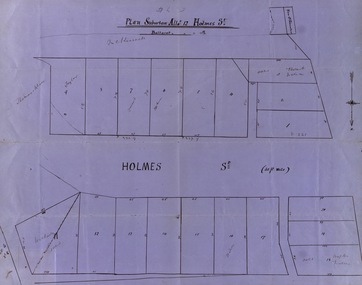 Federation University Historical Collection
Map, Plan subdivision: Allotment 12 Holmes Street, Ballarat
The Allotments drawn in Holmes Street appear to be hand drawn and showing one of the first subdivisions in Ballarat. This was begun in the 1860s. Some names are marked on the blocks - Taylor (9), Holmes (6), Robert Watson (3), Watson (16), Walter (18),Wetherly (11), Vacant (7)Blue paper with black ink showing the land blocks either side of Holmes Street Each block is numbered - 20 in all Names on some blocksNorth indicated with arrow Sizes of blocks - depth and width holmes street, subdivision, allotment 12, holmes, taylor, robert watson, watson, wetherly, vacant -
 Kew Historical Society Inc
Photograph - 'Fairyland', 57 Malmsbury Street, 1960-65
'Fairyland' at 57 Malmsbury Street, Kew - the home and garden of Jim and Grace Tabulo - was a major local, state and international tourist attraction from the 1940s to the mid 1960s. The Kew Historical Society's collection contains original photographs, visitor books and items that were once displayed in the house by the Tabulos. Grace Tabulo died in 1973 and is buried with her husband Jim in the Boroondara General Cemetery (PRES B 1973). Following her death at the age of 88, the house was sold and its contents distributed. The cottage is now a private residence. The 'Fairyland' collection is of local and statewide significance, as a varied and comprehensive record of this major Melbourne tourist attraction. Original, small, black and white photographic positive, of items displayed in the garden of 'Fairyland', at 57 Malmsbury Street, Kew.fairyland, 57 malmsbury street -- kew (vic.), grace tabulo, jim tabulo -
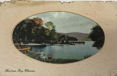 Kew Historical Society Inc
Postcard, Howtown Bay, Ullswater, c.1911
A postcard with an oval photograph of Howtown Bay, Ullswater (Lake District, England) sent to the W.R. Rylah, a solicitor who lived at 31 (now 68) Charles Street in 1911. The postcard and item 2017.0079 were discovered during renovations to the house. Front: "B.B. London Series No. E70 ***" / Reverse: "Wishing you all a bright and happy Xmas + New Year, from all at "Doon", Xmas 1911." Postcard addressed to: "W.R. Rylah, Glen Mavis, [31] Charles Street, Kew".ullsworth, howtown bay, postcards, weir collection, 68 charles street - kew (vic.) -
Port Melbourne Historical & Preservation Society
Photograph - Rooftop view over Stokes Street and the Anchorage apartments, Port Melbourne, Pat Grainger, May 2001
Taken while viewing the Town House being auctioned in Rouse Street cMay 2001From a series of colour photos taken at autumn auctions 2001, photo taken from the rooftop terrace of a town house formerly a part of the Swallow & Ariell offices at Rouse and Stokes: wide view over Stokes Street and the Anchorage:built environment, swallow & ariell ltd, the anchorage -
Port Melbourne Historical & Preservation Society
Photograph - Rooftop view over Stokes Street and the Anchorage apartments, Port Melbourne, Pat Grainger, May 2001
Taken while viewing the Town House being auctioned in Rouse Street cMay 2001From a series of colour photos taken at autumn auctions 2001, photo taken from the rooftop terrace of a town house formerly a part of the Swallow & Ariell offices at Rouse and Stokes: panoramic view over Stokes Street and the Anchorage:built environment, swallow & ariell ltd, the anchorage -
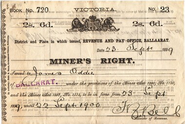 Federation University Historical Collection
Document, Miner's Right made out to James Oddie, 1900-1909, 1900-1909
These Miner's Rights may refer to the Ballarat Observatory in Magpie Street (to be confirmed), and were possibly handed over when James Oddie gifted the Observatory to the Ballarat School of Mines. Seven Miners Rights made out to James Oddie between September 1900 and February 1909. No of Registration in 19578 for 209 feet x 52 feet at Magpie Street, Ballarat East james oddie, miners right, ballarat observatory, d.p. mannix, f. bell, miner's right, magpie street ballarat east, ballarat east -
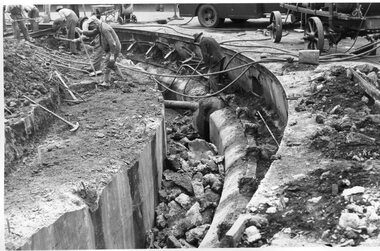 Melbourne Tram Museum
Photograph - Black and White - demolishing cable tram track Smith and Gertrude Streets 1954/55
The photograph shows the demolition or removal of the cable tram track at the intersection of Smith Street and Gertrude St Fitzroy, 1954/55. Photo shows the workmen excavating and demolishing parts of the massive infrastructure needed at this curve to enable cable trams to pass around the sharp curve, still one of the sharpest on today's Melbourne tram system. The outside cable tram track remains in position. The MMBW plan shows a large cable sheave pit on the outside of the curve. The 1955 Annual Report notes that work commenced following the completion of the Queen's visit in March 1954 and that all work was done by day-labour. The track was opened to service in late June 1955. Photographer is possibly Keith Kings.Yields information about the extent of work need to convert the former Northcote Cable tram route to Electric trams, the people, the extent of the original construction and the methods used to undertake the work.Photograph - Black and White - demolishing cable tram track Smith and Gertrude Streets 1954/55trams, tramways, cable trams, workmen, mmtb, demolition, track work, conversion, smith street, gertrude street, fitzroy -
Ringwood and District Historical Society
Envelope, Packet: Ringwood Council and Ron Pullin list of Street Names. 1971 and 1972
Street Names - List of names for consideration for streets in Ringwood +Additional Keywords: Pullin, E.V. -
 Federation University Historical Collection
Postcard - photographic, Clare Gervasoni, Lydiard and Dana Street, Ballarat, 2015, 2015
Views of Lydiard and Dana Street Ballarat from the roundabout at the intersection of those two streets -
 Bendigo Historical Society Inc.
Slide - BENDIGO & EASTER FAIR, c1966
Golden Jubilee Statue. Intersection of McCrae Street Bridge Street and Howard Place, Bendigo.slide, bendigo, golden jubilee statue, golden jubilee statue