Showing 110176 items matching "roads"
-
 Whitehorse Historical Society Inc.
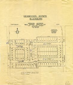
Map, Henwoods Estate, Blackburn
Plan of subdivision in Blackburn SouthPlan of subdivision in Blackburn South between Holland Road and Blackburn Road. Estate advertised by Spencer Jackson, 341 Collins Street.Plan of subdivision in Blackburn South land subdivision, henwoods estate, blackburn south, holland road, brazeel street, marama street, blackburn road, gissing street, hearty street -
 Whitehorse Historical Society Inc.
Map, Springvale Road, 1975
Aerial photograph of area around cnr. of Springvale Road and Burwood Highway, south past Highbury Road and East in Vermont South.Aerial photograph of area around cnr. of Springvale Road and Burwood Highway, south past Highbury Road and East in Vermont South.Aerial photograph of area around cnr. of Springvale Road and Burwood Highway, south past Highbury Road and East in Vermont South.aerial photographs, vermont south, highbury road, burwood east, burwood highway, burwood east, burwood east -
 Whitehorse Historical Society Inc.
Photograph, Deep Creek Road Bridge, 18/04/2001 12:00:00 AM
Coloured photograph looking East from Deep Creek Road Bridge at start of construction of new Deep Creek Road Bridge.deep creek road, mitcham, vicroads -
 Whitehorse Historical Society Inc.
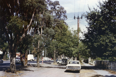
Photograph, Canterbury Road, Vermont, C.1967, C.1967
Part of Tim Shambrook's Collection for 'This is Vermont'. Not used.Coloured photo of Canterbury Road, Vermont, taken from outside Vermont Primary School (since demolished) on corner of Mitcham Road.vermont state school, no. 1022, canterbury road, vermont, shambrook, tim -
 Whitehorse Historical Society Inc.
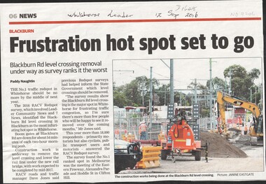
Article, Blackburn Level Crossing, 2016
Blackburn Road level crossing removal is underway with work expected to be completed mid - 2017 by lowering the rail line beneath the road.level crossing removal authority, blackburn railway crossing -
 Whitehorse Historical Society Inc.
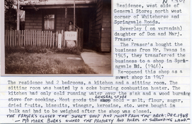
Photograph, Residence attached to General Store, Nunawading, C. 1946 - 1948
Black and white photo of Residence attached to General Store on corner of Springvale Road and Whitehorse Road, Nunawading,C. 1946 - 1948.fraser, don, marj, colin, beverly -
 Whitehorse Historical Society Inc.
Photograph, Market Gardens Blackburn, 1971
Black and white photo showing one of the last Market Gardens in the district. Blackburn Road between Canterbury and Burwood Roads, 1971.market gardens, blackburn, 1971 -
 Ballarat Tramway Museum
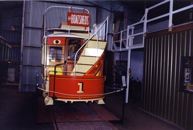
Photograph - Colour Photograph/s, Warren Doubleday, 1/10/1993 12:00:00 AM
Colour photograph taken of BTM Horse Tram No. 1 road at the rear of No. 2 road, October 1993 inside the BTM depot.Initials of "WAD and c1994" on rear in ink.btm, horse trams, btm depot, tram 1 -
 Camberwell Historical Society
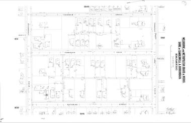
Map (Item) - MMBW map, Melbourne and Metropolitan Board of Works, Melbourne and Metropolitan Board of Works - Shire of Boroondara and Camberwell - Detail Plan no. 1845, August 1904
Lithographer JEM, exd. JWD, June 1904, no. 71. 40P.15W.melbourne and metropolitan board of works, map, camberwell, cartography -
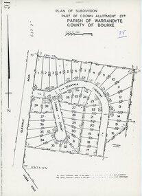 Ringwood and District Historical Society
Map - Plan of Subdivision, Part of Crown Allotment 27B Parish of Warrandyte County of Bourke (undated, circa 1970)
Photocopied subdivision map of 38 residential allotments in Glenvale Road, Cantala Crescent, and Giana Court, north of Kubba Road, Ringwood. -
Canterbury History Group
Map - Victorian Railways, Canterbury, Drainage Plan, cc1910
Drainage plan around Canterbury Station, Canterbury Road and Maling Road .5 pages of photocopies from the Public Record Officecanterbury, canterbury road, maling road, canterbury station, drainage, stormwater channels -
Canterbury History Group
Photograph - Street view looking north up Maling Road including the shop signs of Brittany Cake Shop at No. 114, Milton's at No. 116 and Simple Solutions at No.118, Jan Pigot, 27/03/1993 12:00:00 AM
Coloured photograph of the street view of Maling Road looking north towards Canterbury Road with Shop 114 , 116 and 118 in view.canterbury, maling road, shops, wunderlite pressed metal ceilings, street signs -
Canterbury History Group
Photograph - Side view of the Canterbury Post Office at No. 206 Canterbury Road and the post boxes and Telephone Exchange on Maling Road, Jan Pigot, 27/03/1993 12:00:00 AM
Coloured photograph of the side view of the Canterbury Post Office at No. 206 Canterbury Road and the post boxes and Telephone Exchange on Maling Roadcanterbury, maling road, shops, post offices, telephone boxes -
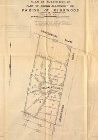 Ringwood and District Historical Society
Map - Plan of Subdivision, Part of Crown Allotment 39, Parish of Ringwood, County of Mornington - (Undated, circa 1950)
Map showing residential allotments numbered 1 to 13 on Valdale Court and Armstrong Road off Canterbury Road, Heathmont, Victoria. Richard Rogalsky, Land Surveyor and Town Planner, 25 Napier Street, Essendon (at Essendon Junction) 37-2642 - 37-6570. -
 Bendigo Historical Society Inc.
Document - Hustlers, Sheepshead and Deborah lines of reef
Albert Richardson was a mining historian who wrote widely on the mines of the Bendigo Goldfield. The park opposite the Goldmines Hotel in Marong Road, is named in his honour. Five page document, hand written by Albert Richardson on lined foolscap and edited with cross-outs and insertions, . The mines along the Hustlers line of reef and the Sheepshead line of reef are described. Mines listed on Hustlers line of reef: Fortuna Hustlers (1888 - 1913), shaft 2,240 feet at rear of Buckell and Jeffrey's offices; Royal Hustlers Reserve No. 2 - two shafts 'City" 860 feet, now covered by R.S.L. building Pall Mall, steel poppet legs 60 ft high and 'Park Shaft" at rear of Camp Hill School, 1,775 feet, steel poppet legs 60 feet high; Hustlers Hill Group first worked by Jonathan Harris in 1853 and bounded by Valentine, Anderson and Ironbark Creek to the north and Milroy Street to the east, one of first areas worked for quartz reefing. It with Garden Gully line west and Victoria Hill Ironbark, formed by far the richest cross section of the Bendigo Goldfield. Great Extended Hustlers (1865-1921) close to intersection of Anderson Street and Hustlers Road, mullock heap against road and shored up around shaft, steel poppet legs now at Wattle Gully mine, Chewton, large winding machine, air compressor south of shaft and 36 head crushing battery. Hustlers Reef (Old Hustlers) and Hustlers Reef No. 1, two shafts, main 2,210 feet, about 220 yards east of Moran Street and against Fenton Street. , No. 1 shaft 1,140 feet and about 155 yards east of Moran Street. Lansell's Comet, Lightining Hill line, 2.100 feet, on Comet Hill approx 70 yards west of Holmes Road, near Comet Creek, steel poppet legs. United Hustlers and Redan (1876-1918), main Redan, 1,830 feet about 155 yards west of Sandhurst Roead, in line with Comet Hill State School, this hill known as Redan Hill. North, or New Hustlers, once known as Agnew Hustlers, wooden poppet legs, south side, Kneebone Street, Eaglehawk. Derby line, Johnson's No. 3, South Johnson's (east shaft of Collman and Tacchi) 439 feet on west wide of Woods Street, south of Wetherall Street. Paddy's Gully Line, south to north, some shafts - Lansell's 'Sandhurst" ('Needle") Eaglehawk Road shaft 2,425 feet, about 50 yards east of Needle Loops, a brick square sided chimney with Cleopatra Needle top. British American, 789 feet, just south of Holdsworth Road. Collman and Tacchi, main shaft 2,588 feet, 60 yards west of Eaglehawk Road, California Gully. Deborah Line of Reef, The Deborah (1932-1954) shaft 2.017 feet, west of Adams Road and south of Abel Street, Quarry Hill. North Deborah (1937 - 1954) shaft 1,151 feet, Breen Street, Quarry Hill, steel poppet legs. Central Deborah (1939-1954) shaft 1,347 feet Sheepshead line of reef, Lansell's South Red, White and Blue, shaft 2,124 feet, north east of Bellevue Road and 220 yards east of Adams Road. The New Red, White and Blue Consolidated (Big Blue) main shaft 2,416 feet. Lansell's Bendigo Battery 105 head, north of 'Big Blue" on his freehold lease, commenced crushing on 24th February 1895. After closing was erected as the Showground's Industrial Hall, July 1926. North Red, White and Blue, burnt down February 1926, new company 1934, closed 1938. Document is part of the Albert Richardson Collection of Bendigo mining history. bendigo, gold mining, deborah line of reef, sheepshead line of reef, hustlers line of reef, royal hustlers reserve mine, hustlers hill group of mines, great extended hustlers, hustlers reef no. 1, lightning hill line, old comet, collman and tacchi, lansell's comet, north deborah, central deborah, dhrrpdhrsf linr og trrg, new red, white and blue consolidated mine, big blue, lansell's bendigo battery, north red, white and blue mine, albert richardson collection -
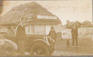 Phillip Island and District Historical Society Inc.
Photographs, 1926
Part of a collection of photographs out of an old photo album with multiple photos on each page. Donated by Margaret Webster. Margaret's parents were Sir Charles & Lady McGrath who lived near the RSL in Ventnor Road, Cowes.286-18 - Sepia photograph of The Tea Room at Shelly Beach, Phillip Island or San Remo?. Two men, a lady and dog beside two cars. One car has a woman inside. 286-19 - Sepia photograph of a group of 13 people in coastal scrub land at Shelly Beach. 286-20 - Sepia photograph of a group of 13 people in coastal scrub land at Shelly Beach. 286-21 - Sepia photograph of a group of people having a picnic in front of the San Remo Hotel. 286-22 - Sepia photograph of 3 people at The Nobbies, Phillip Island. 286-23 - Sepia photograph of rough seas at The Nobbies, Phillip Island. 286-24 - Sepia photograph of a man with a young penguin possibly at Slummerlands Phillip Island. 286-25 - Sepia photograph of breakers at The Nobbies, Phillip Island. 286-26 - Sepia photograph of The Continental Guesthouse with guests on the verandah. 286-27 - Sepia photograph of an unmade road with scrub vegetation on the sides. 286-28 - Sepia photograph of Cowes foreshore with the Jetty in the background. 286-29 - Sepia photograph of the Cowes Jetty with people arriving off a ferry. 286-30 - Sepia photograph of Cowes foreshore with the Jetty in the background and a ferry.286-18 - "The Teahouse - Shelly Beach" 286-19 - "A Confidential Chat - Shelly Beach" 286-20 - "The Wanders - San Remo" 286-21 - "Lunch at San Remo" 286-22 - "The Nobbies - P.I." 286-23 - "Rough Seas - The Nobbies" 286-24 - "A Young Penguin" 286-25 - "Breakers - The Nobbies" 286-26 - "The Contin - Cowes" 286-27 - "The Road to the Back Beach" 286-28, 29 & 30 - "Beach and Jetty at Cowes"the nobbies phillip island, young penguins, wildlife - penguins, tea house behind shelly beach, shelly beach, san remo hotel, the continental guesthouse, the continental hotel, cowes jetty, margaret webster -
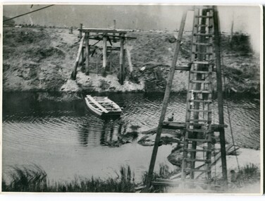
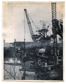 Orbost & District Historical Society
black and white photographs, 1975
These are photographs of the construction of the current cement road bridge across the Snowy River at Orbost. Construction of the bridges commenced in January 1975, with an expectation to open the bridge across the Snowy River as soon as possible. Less than two years later, on 25 November 1976, the bridge across the Snowy River was opened to traffic, allowing the old bridge to be demolished. The remainder of the Orbost Bypass, both the floodplain crossings and the eastern section around the township itself, was declared ‘Princes Freeway’ and opened to traffic in December 1977. (ref http://mrv.ozroads.com.au)The opening of this Snowy River Bridge was an important development in the accessibility to the township of Orbost. These photographs record its construction.Two black / white photographs showing the construction of a road bridge across a river. 3257.1 shows piles being dropped beside the bridge, 3257.2 is of the early stages of construction of this bridge.snowy-river-bridge-orbost road-construction-orbost bridge-orbost -
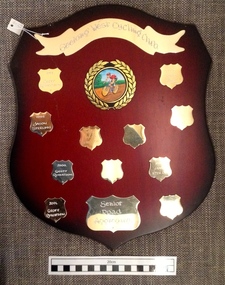 Geelong Cycling Club
Wooden Shield, 1998
Shield prepared for the senior road aggregate races for the Geelong West Cycling Club which then became the Geelong Cycling Club. The 2005 winner - Leigh Howard, was a professional rider with Team Colombia in 2010 and is currently on the pro tour with Orica Green Edge (commencing 2012). He was the World Omnium Champion in 2009, and World Madison Champion 2010 and 2011.This shield records the cyclists who were high achievers in the Geelong region.A mahogany coloured wooden shield with brass plated plaques containing inscriptions of winners of the senior road aggregate of the Geelong West Cycling Club during the years 1998-2002. There is an emblem of a cyclist and a banner at the top centre of the shield."Geelong West Cycling Club/1998/Geoff Robertson/1999/Jason Sterling/2000/Geoff Robertson/2001/Geoff Robertson/2002/Geoff Robertson/2003/James Stewart/2004/Daryl Suter/2005/L. Howard/G.Mathieson"geelong west cycling club; geoff robertson; jason sterling; james stewart; daryl suter; l. howard; g. mathieson; -
 Orbost & District Historical Society
black and white photographs, 1915
This photograph is of the construction of the first road bridge over the Genoa River - 1915. Before today's timber truss and concrete bridge was constructed between 1926-1928 by contractor J.T. Noble Anderson, two earlier bridges crossed the Genoa River at this location. They provided crucial links in the Princes Highway route from Melbourne to Sydney. The letter on the back of the postcard was written by Gordon ? to Alex ? on 2nd October 1917. "this represents the opening of Genoa Bridge. Mrs Alexander cutting the ribbon and Mr Martin holding it at the other side. Did most of the speaking. The gent holding the roll of paper is who came to open the bridge. I can't think of his name. Hubert is standing up at the right / Gordon " This is a pictorial record associated with the history of Genoa in East Gippsland.1100 -A large black / white photograph on a cream coloured buff card. It is of an unfinished bridge with men working there. A small rowboat can be seen on the far side of the river. 1100.1 - A photograph / postcard of the opening of "Genoa Bridge 1917". There is a ribbon stretched across the timber decking road in front of a group of people. 1100.2 - A black / white photograph of a road bridge across a river.on back - "Princes Highway - the 1st bridge over the Genoa River - 1915" on back of 1100.1 is a hand-written letter.genoa-bridge princes-highway-east-gippsland -
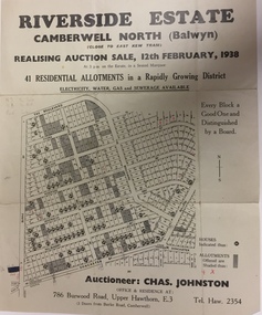 Kew Historical Society Inc
Plan - Subdivision Plan, Riverside Estate, Camberwell North (Balwyn), 1938, 1939
This subdivision known as the Riverside Estate wa sone of the largest and most significant in Balwyn's history.Subdivision Plan for 41 lots within the wider Riverside Estate in Camberwell North, now Balwyn, in February 1938. The auction featured lots in Burke Road, The Boulevard, Mt View Road, Wattle Avenue, Kyora Parade, Cascade Street, Riverside Avenue, Walbundry Avenue, Inverness Way, Bulleen Road and Doncaster Road.Allotments for sale are shaded grey on the map. Certain lots have an H in a circle. These are presumably where houses had already been constructed.subdivision plans - balwyn (vic), riverside estate - balwyn (vic) -
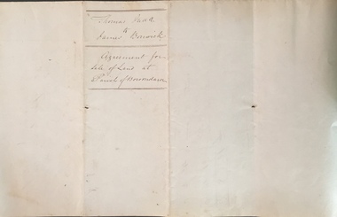 Kew Historical Society Inc
Legal record (Item), Thomas Judd to James Bonwick: Agreement for Sale of Land at Parish of Boroondara, 1853, 28/02/1853
James Bonwick (1817-1906), the Victorian educator and historian, acquired land in Kew on which to establish a home and school in 1853, not 1854 as more commonly stated. Bonwick returned to England in 1859 for a period, later returning to Melbourne and settling in St Kilda. He was the author of a number of histories and an official transcriber of Government records.This newly acquired document, from a former owner of 'Parkhill' (20 Hillcrest Avenue, Kew), is of statewide importance as it is the original copy of the agreement made between Thomas Judd of Parkhill and James Bonwick in 1853 for the purchase of land in Kew. Both Thomas Judd and James Bonwick were significant pioneers of Victoria.TRANSCRIPT [TITLE] Thomas Judd to James Bonwick Agreement for Sale of Land at Parish of Boroondara [PAGE 1] Articles of agreement made and entered into this the Twentyth eighth day of February One thousand Eight Hundred and fifty three Between Thomas Judd of Melbourne in the Colony of Victoria Gentleman of the one part and James Bonwick of Melbourne in the Colony of Victoria Gentleman of the other part whereby the said Thomas Judd agrees to sell unto the said James Bonwick who hereby agrees to purchase a piece or parcel of land containing two and half acres be the land more or less part of Portion Number Eighty five of the Parish of Boroondara in the County of Bourke commencing at a point on the Northern boundary line of the said Portion Seventeen Chains fifty links East from the North West angle of the same and bounded on the East by other part of said Portion in a line bearing South Eight Hundred and sixty two feet on the South by other part of said Portion Eighty five in a line bearing West one Hundred twenty six and half feet on the West by other part of said Portion Eighty five in a line bearing North Eight Hundred and Sixty two feet on the North by the Northern boundary line of the said Portion Eighty five in a line bearing East one Hundred twenty six and half feet to the commencing point at or for the price or sum of one [PAGE 2] One Hundred Pounds to be paid and payable in the manner hereinafter mentioned that is to say the Sum of Thirty pounds to be paid on the day of the date hereof and the sum of forty pounds by the acceptance of the said James Bonwick for that sum at three months bearing interest thereon after the rate of Eight Pounds per centum per annum and the Sum of Thirty pounds by the acceptance of the said James Bonwick for that sum after Six months with interest thereon after the rate of Eight pounds per centum per annum It is furthermore agreed that the said James Bonwick shall have access by a right of way fifteen feet wide reserved by the said Thomas Judd to the Government Road being the Southern Boundary of Portion Eighty five. That in case default shall be made in the payment of any of any of the Acceptances above mentioned the amount paid shall be actually forfeited to the said Thomas Judd who shall be at liberty to resell the premises. That upon payment of the whole amount of the purchase money the said Thomas Judd shall execute a conveyance of the premises to the said James Bonwick Such conveyance to be prepared by and at the expense of the said James Bonwick who - [PAGE 3] who shall also pay the cost of any attested copies he may require. ---- As witness the hands of the said parties this the twenty first day of February one thousand Eight Hundred and fifty Three. ----- [Signature] T. Judd [Signature] Jas Bonwick Witness [Signature illegible] £ Received Cash on account of the above 30.0.0 Thirty Pounds Bill at three Months with interest 42.4.0 Bill at Six Months with interest 31.4.0 _____ £103.8.0 _____ [Signature] T. Judd [Signature] Jas Bonwick ------------ Transcribed David White 25/08/2020 james bonwick, thomas judd, land titles - kew (vic), pioneers - kew - victoria -
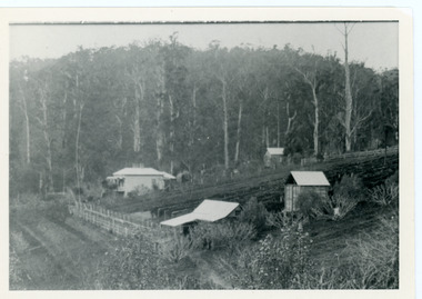 Mt Dandenong & District Historical Society Inc.
Photograph, George Barber's Home Forest Edge after 1912 Looking South West, c1912
George Barber built a homestead later named Forest Edge on Barber's Road and lived there with his wife Sarah Ann (nee Richardson).Black and white photograph showing the side view of a house and three outbuildings. Reverse of photograph has handwritten description by John Lundy-Clarke.George Barber's home on bend of Barber's Road on Lot 25, Village Settlement. Showing passionfruit plantation. Buggy shed top right. Hay shed lower right. Stables, cart shed and men's quarters lower left about 1912. Photo copied by JLC in 1973.forest edge, george barber, sarah ann barber, kalorama, barber's road -
Whitehorse Historical Society Inc.
Document, Andreas Fritsch, 1992
History and maps of the brick quarry opened by Andreas Fritsch in Nunawading in 1856.History and maps of the brick quarry opened by Andreas Fritsch in Nunawading in 1856. His quarry was between Burwood Road and Mahoneys Reserve, enclosed with a letter from Geoff Ford, historian and pottery collector to Mrs B. Gray. Information on history taken from Niall Brennan's 'History of Nunawading'.History and maps of the brick quarry opened by Andreas Fritsch in Nunawading in 1856. clay, fritsch, andreas, ford, geoff, gray, beryl, pottery -
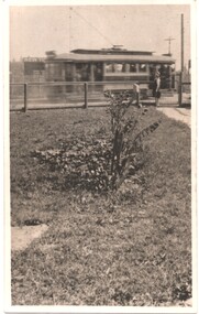 Melbourne Tram Museum
Photograph - Black and White photograph, 11/01/1925 12:00:00 AM
Black and white photograph of MMTB B class No. 23 taken from a front verandah on its first trip at the corner of High St and Woodlands Ave 11-1-25 on the return trip from Burke Road to Kew Depot. A young lady is standing by the front fence. The tram is well loaded with passengers and possibly the conductor standing in the rear section of the tram, revelling at speed.On rear in ink "MMTB No. 23 taken from a front verandah on its first trip at the corner of High St and Woodlands Ave 11-1-25 on the return trip from Burke Road to Kew Depot."trams, tramways, high st kew, b class, opening, tram 23, mmtb -
Glen Eira Historical Society
Caulfield Transport
Photographs of transport in Caulfield, primarily by roadcaulfield, transport -
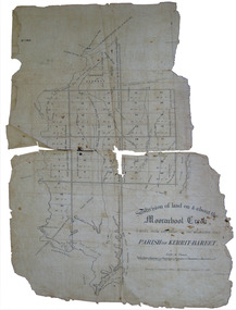 Federation University Historical Collection
Plan, Eugene Bellairs, Moorabool Creek, Parish of Kerrit-Bereet, 01/08/1855
Plan of the Moorabool Creek on the Melbourne Roadmoorabool, kerrit-bareet, moorabool creek, eugene bellairs -
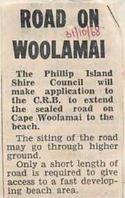 Phillip Island and District Historical Society Inc.
Newspaper Clipping, 31/10/1968
Newspaper clipping 1968article on application to extend Woolamai Roadphillip island, cape woolamai, woolamai road -
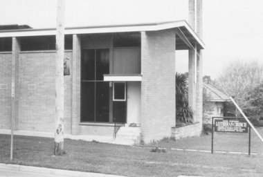 Ringwood and District Historical Society
Photograph, Lutheran Church in Wantirna Road, Ringwood in 1974, 1974
Lutheran Church in Wantirna Road in 1974Written on back of photograph, "5.10.74" -
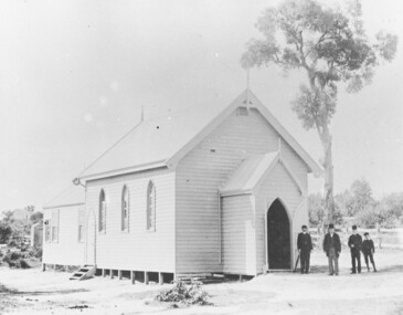 Ringwood and District Historical Society
Photograph, St Paul's Church, Whitehorse Road, Ringwood, Vic. circa 1910
St Paul's Church on Whitehorse RoadWritten on back of photograph, "St. Paul's on highway." -
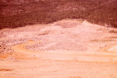 Stawell Historical Society Inc
Slide, Ian McCann, The Dam Base, 1963
Colour Slide: The bae of the dam with roadslake bellfield