Showing 23714 items
matching creeks
-
 Bendigo Historical Society Inc.
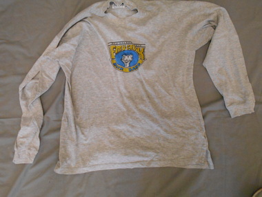
Clothing - LONG SLEEVED EMU CREEK BUSH BAND WIND - CHEATER, 1990's
Clothing. Long- sleeved grey cotton wind-cheater, with a printed blue. yellow and black,shield-shaped logo on the front, featuring the caricature of an emu's head and the words, ''The Celebrated Emu Creek Bush Band''. Long sleeves with a 4 cm deep cuff,high round neckline with a 3 cm deep neckband, 7 cm deep splits at the hemline of each side seam, and a 4 cm deep cuff, at the lower edge of the set-in sleeves.Worn by Peter Ellis, OAM, founder and leader of the celebrated Emu Creek Bush Band, circa 1990's.JEANS PLUS, Made in China. 100% cotton, and washing instructions.costume, male uniform, civilian, wind-cheater -
 Bendigo Historical Society Inc.
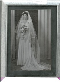
Photograph - AILEEN AND JOHN ELLISON COLLECTION: FRAMED WEDDING PHOTOGRAPH OF BRIDE, 24 September 1949
Photograph. 12.5 cms x 17.5 cms, in a plain silver frame. In black and white, this photograph shows bride Aileen Beryl Ervin of McKenzie Creek, via Horsham, in her wedding attire, for her marriage to Leslie John Ellison, of McKenzie Creek via Horsham. This ceremony was officiated by Rev. Francis Fielding, on September 24th 1949, in the Horsham Methodist Church. The bride wore a beautiful gown, with a short and a long veil. Her flowers trail beautifully and she appears to be holding some horseshoes over her left arm.photograph, person, photograph of bride. -
 Upper Yarra Museum
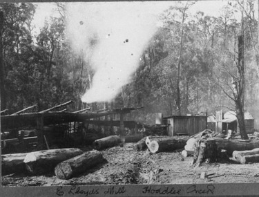
Negative Photographic Reproduction, E Lloyds Mill, Hoddles Creek, 13/4/1983
This looks like a typical Bush Timber Mill of the period, E Lloyd's Mill, Hoddles Creek Negative Black white. Scanned at 600 dpi. There are five men at work at the mill and also a lady sitting on the front verandah of the nearest hut, possibly mending some material , there are 2 other. hutse lloyds mill timber workers women hoddles creek logs sandy ross -
 Federation University Historical Collection
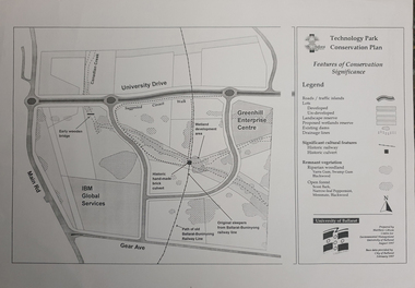
Map, Matthew Cibson, University of Ballarat Centre for Environmental Management, Ballarat Technology Park Conservation Plan, 1997, 02/1997
The Ballarat Technology Park is on the Federation University Mount Helen CampusMap showing the Ballarat Technlogy Camp, Greenhill Enterprise Centre, Canadian Wetlands. hand-made brick culvert sleepers, Ballarat-Buninyong Railway Line, IBM Global Services, early wooden bridge, Canadian Creek, Gear Avenue. ballarat technology park, canadian wetlands, greenhill enterprise centre, brick cultert, railway, ballarat-buninyong railway -
 Federation University Historical Collection
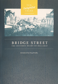
Booklet, Doug Bradby, Bridge Street: The Historic Heart of Ballarat, 2020
Twenty eight page dark green covered book on Ballarat's Bridge Street, including information on the Gravel Pits, Main Road shops, floods, Chinese cerneval, Queen carneval, Yarrowee Bridge, Eureka Stockade, fire, Yarrowee Creek.non-fictionballarat, gravel pits, main road shops, floods, chinese cerneval, queen carneval, yarrowee bridge, eureka stockade, fire, yarrowee creek, bridge street -
 Ringwood and District Historical Society
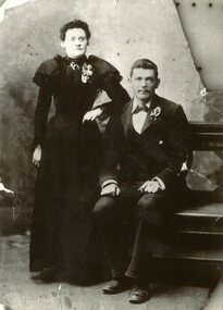
Memorabilia, Lola Tindal Recollections and wedding photo of Susannah and Alfred Tindal
Wedding photo of Susannah and Alfred David Tindal circa 1890. They lived at Tindal's road, Anderson Creek (Warrandyte). Also recollections written by Lola Tindal who grew up on orchards in Ringwood/Heathmont, written on 1st November 1995. -
 Glenelg Shire Council Cultural Collection
Photograph - Photograph - Portland, n.d
Con Kroker Collection -
 Ringwood and District Historical Society
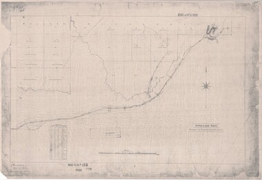
Map, Road Plan 108 - Gipps-land Road, Parishes of Bulleen and Warrandyte (Ringwood, Victoria) - 1855
Surveyor's map of the part of the main road from Melbourne to Gippsland following "Barker's Track" south of Mullum Mullum or Deep Creek. Map references include Roman numerals marking distances measured in Links between trees at turns in the road.Submitted to the Surveyor General (Signed) July 2nd 1855. -
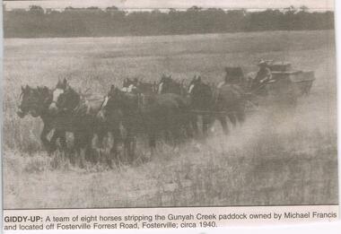 Bendigo Historical Society Inc.
Newspaper - JENNY FOLEY COLLECTION: GIDDY-UP
Bendigo Advertiser ''The way we were'' from 2003. Giddy-up: a team of eight horses stripping the Gunyah Creek paddaco owned by Michael Francis and located off Fosterville Forrest Road, Fostervill; circa 1940. The clip is in a folder.newspaper, bendigo advertiser, the way we were -
 Bendigo Historical Society Inc.
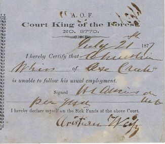
Document - ANCIENT ORDER OF FORESTERS NO 3770 COLLECTION: DOCTOR'S CERTIFICATE
Blue Doctor's Certificate dated May 24th 1877 certifying that Christian W? of Axe? Creek was unable to follow his usual employment. Signed by H. L. Atkinson. Signed at the end by G. Hooley declaring himself on the Sick Funds.societies, aof, correspondence, ancient order of foresters no 3770 collection - doctor's certificate, court king of the forest, christian w?, h l atkinson -
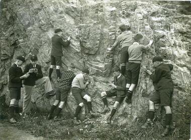 NMIT (Northern Melbourne Institute of TAFE)
Photograph: CTS Geography Excursion 1920s
Black and white photo of Collingwood Technical School male students in school uniform, some with caps, examining a rockface. On the reverse of the photo is a pencil note 'English Department / Georgraphy Excursion. Undated but estimated to be in the 1920s, and possibly in the Merri Creek area.collingwood technical school, students, nmit -
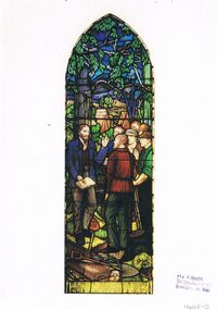 Bendigo Historical Society Inc.
Document - HOSKING AND HUNKIN COLLECTION: PICTURE OF A GLASS WINDOW
Document. Printed coloured picture of a stained glass window. Accompanying note identifies it as "Local Preachers Window, Uniting Church, Castlemaine". See note 11402.14. Window depicts a local preacher on the Forest Creek Goldfields during the 1950's.print, buildings, stained glass window -
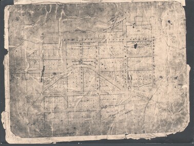 Bendigo Historical Society Inc.
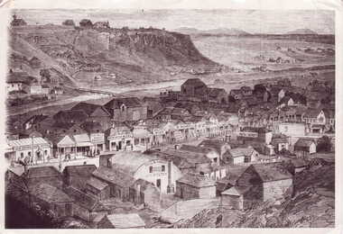
Photograph - WES HARRY COLLECTION: TOWNSHIP OF SANDHURST, 1854
Photograph of the Parish Plan of the Township of Sandhurst in 1854. It covers the area of the CBD from Mitchell (not named) to Bernal Streets and from the Bendigo Creek to Mollison St. ( other than Pall Mall and McRae streets, none of these parallel streets are named)place, bendigo, first survey, sandhurst, first survey, bendigo creek -
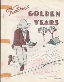 Bendigo Historical Society Inc.
Document - HARRY BIGGS COLLECTION: VICTORIA'S GOLDEN YEARS, October 1965
A booklet published by the Mines Department Melbourne, Victoria in October 1965 on the history of the discovery of gold in Victoria. It has been stapled together, and the cover depicts a miner panning for gold on the edge of a creek, his tent and some trees are visible in the backgroundMines Departmenttopic, mining, gold discovery, mines department, gold discovery, history of gold in victoria -
 Lakes Entrance Regional Historical Society (operating as Lakes Entrance History Centre & Museum)
Book, The Maryborough Region Bushfire January 14 1985, 1985
The story of the fire which devastated the Central Victorian region on Monday, January 14, 1985.Towns and locations were Bung Bong, Amherst, Talbot, Dunach, Daisy Hill, McCallums Creek, Majorca, Bristol Hill, Maryborough and Carisbrook. Illustrated withnatural disasters, photography -
Lakes Entrance Regional Historical Society (operating as Lakes Entrance History Centre & Museum)
Postcard, 1910 c
Black and white postcard showing view of Reeves channel looking west toward Metung west end of Rigby and Fraser Islands mouth of Maringa creek lower right with neat mill workers cottages on flat Lakes Entrance Victoriatownship -
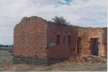 Clunes Museum
Photograph
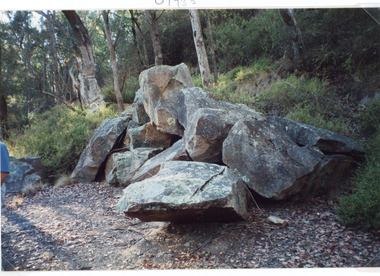
COLOURED PHOTOGRAPH BRICK BUILDING WITH BLUESTONE FOUNDATIONS-IN STATE OF DISREPAIR. ROOF DOORS & WINDOWS MISSING, SMALL PILE OF BRICK RUBBLE AT FRONT DOOR.--BUILDING COULD BE REMAINS OF POWDER MAGAZINE NEAR BIRCHES CREEK. BOXTHORN GROWING IN GUTTERING.local history, photography, photographs, mining, powder magazine -
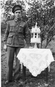 Ballarat Heritage Services
Photograph - Black and White, Vince Gervasoni and his 21st birthday cake
Vince was the youngest son of John and Catherine Gervasoni, and the grandson of Luigi Gervasoni. Black and white photograph of Vince Gervasoni in World War 2 AIF uniform, standing next to his 2 tier 21st birthday cake. The photograph was taken in the back yard of his famile's Yandoit Creek farm 'Pine View'. yandoit creek, vince gervasoni, birthday cake, world war 2 -
 Lakes Entrance Regional Historical Society (operating as Lakes Entrance History Centre & Museum)
Photograph, Fish Marie, 1997
Date made 18 January 1997Colour photograph of a pile of granite rock left on the bank of the North Arm. This rock was quarried at Mississippi Creek and conveyed by tramline to the North Arm where it was loaded on barges and conveyed to the entrance where it was used to stabilise the piers. Lakes Entrance Victoriaboats and boating, waterways, machinery, public works -
 Lakes Entrance Regional Historical Society (operating as Lakes Entrance History Centre & Museum)
Photograph, 1984
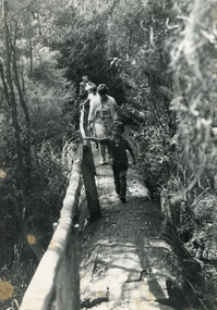
Black and white photograph of two adults Lyn Winnett and Dominique (Dommie) Spiller plus children walking along bush track, pine log hand rail, at Mississippi Creek Track, at primary school picnic day. Jonsonville Victoriaschools -
 Southern Sherbrooke Historical Society Inc.
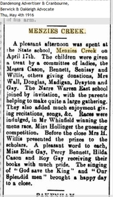
Article - Menzies Creek State School article, Menzies Creek
An article from the Berwick and Oakleigh Advocate dated 4th May 1916, reporting an afternoon gathering at the Menzies Creek State School held on 17th April 1916. Narre Warren East State School was also invited to join the afternoon. -
 Bendigo Historical Society Inc.
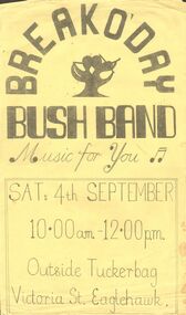
Document - PETER ELLIS COLLECTION: BREAK O'DAY BUSH BAND
Yellow with black printing poster for Break O'Day Bush Band. Band was playing on Sat. 4th September, outside Tuckerbag, Victoria St. Eaglehawk. Written on the back - Peter Ellis's first band which later became Emu Creek.entertainment, music, bush band, peter ellis collection, break o'day bush band, tuckerbag, emu creek -
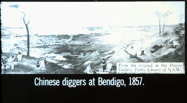 Bendigo Historical Society Inc.
Slide - DIGGERS & MINING. THE CHINESE ON THE GOLD FIELDS, c1857
Diggers & Mining. The Chinese on the Gold Fields. Slide: Chinese diggers at Bendigo, 1857. Slide shows Chinese panning for gold in the almost baron land of Bendigo. Possibly along side the Bendigo Creek. Markings: 28. Used as a teaching aid.hanimounteducation, tertiary, goldfields -
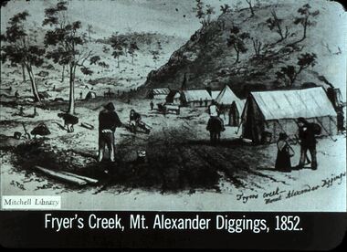 Bendigo Historical Society Inc.
Slide - DIGGERS & MINING: THE DIGGINGS - THE DIGGERS
Diggers & Mining: The Digging - The Diggers. Slide depicts Fryer's Creek, Mt. Alexander Diggings, 1852. Shows tents, miners, small girl, not many trees at the foot of a hill. Markings: 16 994.LIF:6. Used as a teaching aid.hanimounteducation, tertiary, goldfields -
 Clunes Museum
Photograph, 1869
UNION BANK - LATER A.N.Z. NOW PRIVATE RESIDENCE. CORNER OF TEMPLETON ST. NEXT TO C. OF E. - NOW SUNDAY SCHOOL. NEXT TO PRESENT C. OF E. NOTE BELL ON BUILDING NEXT TO RED BOOT WAS A SCHOOL.- TWO CHURCHES ON TOP OF NORTH CLUNES HILL. ONE OF THESE BECAME THE ASSEMBLY HALL AT TOWN HALL. SIGNS ON BUILDINGS, KENT EDWARD DART HOTEL, PITCHER BROS, PORT PHILLIP BAKERY R. HARVEY, C. WILES WASHINGTON HOTEL, R. MORRISON AGE OFFICE NEWS, BULL & MOUTH COACH OFFICE J. H. DALTON.1 PHOTOGRAPH OF WHAT COULD BE A LITHOGRAPH OF LOWER FRASER STREET, CLUNES. WOODEN BUILDINGS IN FOREGROUND, CRESWICK CREEK BEHIND BUILDINGS. HILL IN BACK GROUND. .2 .3 BLACK AND WHITE COPIES OF THE ABOVE PHOTOGRAPH PRINTED ON GLOSS PAPERshops, red boot palace, clunes township -
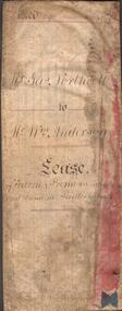 Bendigo Historical Society Inc.
Document - INDENTURE DOCUMENT BETWEEN JAMES NORTHCOTT AND WILLIAM ANDERSON
Indenture document, hand written in ink and ruled in red ink, between James Northcott, farmer and William Anderson ' of the same place' for 380 acres at Bullock Creek. Document is in poor condition and folded in four sections. Document dated 1870.rural industry, farm property, indenture northcott and anderson -
 Bacchus Marsh & District Historical Society
Map, Township of Maddingley, Parish of Parwan, County of Grant
This map is dated Sept. 6th 1856. However places in the township of Maddingley which did not appear until the late 1880s such as the Bacchus Marsh Railway Station and line are shown on this map in their correct locations. This suggests the map has been derived from an earlier map. An earlier date of 1843 with a surveyor's name preceding it can also be seen on the map. The map is important because it indicates the location and dimensions of early but now discontinued use of land such as the showgrounds and police paddock and a site reserved for the Church of England which was not ultimately used for a permanent church. A single page paper map showing land allotments, streets, rivers, creeks, park lands, the railway line and Bacchus Marsh railway station in the township of Maddingley. The map is pasted into a bound volume containing 76 maps or plans in total. Bottom of Map: Surveyor-General's Office, Melbourne, Sept 6th, 1856bacchus marsh victoria maps, maddingley victoria maps, land use, maddingley victoria history -
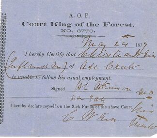
 Bendigo Historical Society Inc.
Document - ANCIENT ORDER OF FORESTERS NO 3770 COLLECTION: DOCTOR'S CERTIFICATE
Blue Doctor's Certificate dated July 21st, 1877, certifying that Christian Weip of Axe Creek was unable to follow his usual employment. Signed by H. L. Atkinson. Signed at the end by Christian Weip declaring himself on the Sick Funds.societies, aof, correspondence, ancient order of foresters no 3770 collection - doctor's certificate, court king of the forest, christian weip, h l atkinson -
 Eltham District Historical Society Inc
Photograph, Mr Yates, Clerk of the Course for the Diamond Creek Racing Club, c.1880
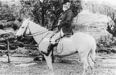
Photo from J. Sinclair reproduced on p92 of The Diamond Valley Story by Dianne H. Edwards, Shire of Diamond Valley 1979. "Mr Yates of Pine Grove, Upper Diamond Creek was the local postmaster, and Clerk of the Course for the Diamond Creek Racing Club in the 1880s. He is dressed for a meeting - the coat was scarlet. When racing ended at Diamond Creek in the 1890s he became Clerk of the Course at the Yarra Glen track."Black and white copy of photo printed on glossy photographic paper 30.5 x 40.5 cm (12 x 16 inch); image size approx. 18.5 x 28 cmclerk of the course, diamond creek racing club, diamond valley story, horse, mr yates, pine grove, postmaster, upper diamond creek -
 Ringwood and District Historical Society
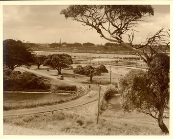
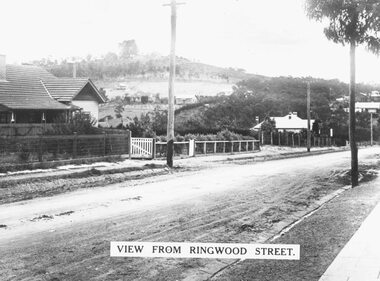
Photograph, Looking north along Ringwood Street from corner of Bond Street, Taken mid 1930s
Typed below photograph, "Looking north along Ringwood Street from corner of Bond Street. Mullum Creek is in dip. Note how bare Loughnan hill was. Taken mid 1930s".