Showing 11340 items matching "land-clearing"
-
 Glenelg Shire Council Cultural Collection
Photograph - Photograph- land reclamation, n.d
Port of Portland Authority Archivesport of portland archives, k s anderson wharf, botanic gardens, reclamation, ocean pier -
Glenelg Shire Council Cultural Collection
Photograph - Photograph - Aerial photograph of coastline around Portland Victoria, c. 1954
Black and white aerial photograph of coastline around Portland. Black border, bottom edge, section of larger photo, approximately 50%, only land visible.Front: 'PORTLA' -printed, white border -
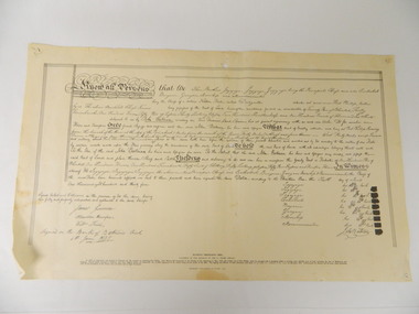 Kiewa Valley Historical Society
Deed, Batman's Melbourne Deed c1835, Original 6 June 1835. Copied 1966
Facsimile of the oriental in the Latrobe Library of the acquisition of 600,000 acres of land (sites of Melbourne & Geelong) between John Batman & Principal chiefs of Dutteallar native tribe.john batman. -
 Ringwood and District Historical Society
Plan, Ringwood Station Estate, Subdivision, Ringwood, Victoria - circa 1925
ID 5224 note: Further information relating to squares marked H, F, G, J, and K included in ID 5225 - Ringwood Shop and Dwelling Estate.Hand drawn plan of Ringwood Station Estate showing allotments for sale, with two typed pages attached showing land title information and sale prices.Drawn by Edyth Greenwood, phone 988 Central. Subdivision includes Station Street, Pitt Street, Bedford Road, Wantirna Road, James Street, William Street (later Kendall Street), Greenwood Avenue, Ellison Street, and Haig Street. Circles denote blocks for sale. Squares denote house properties for sale. Other features marked include location of businesses along Main Street (Maroondah Highway), cool store, railway station, shop and police station on Bedford Road, church on Station Street, site of schoolmaster's residence and State School, and location of proposed public baths. Ryner & Langford, Solicitors -
Glenelg Shire Council Cultural Collection
Photograph - Photograph - Foreshore Development, n.d
Port of Portland Authority ArchivesBack: fd005, bottom right, pencil.port of portland archives, reclamation henty beach, bentinck street -
Glenelg Shire Council Cultural Collection
Photograph - Photograph - tug 'Trewalla', n.d
Port of Portland Authority Archivesport of portland archives, tug boat, trewalla -
Glenelg Shire Council Cultural Collection
Photograph - Photograph - Portland Harbour, Jun-92
Port of Portland Authority ArchivesFront: Back- 6/92-Blue biroport of portland archives, portland maritime discovery museum, land reclamation -
Glenelg Shire Council Cultural Collection
Photograph - Photograph - Portland Harbour, Jun-92
Port of Portland Authority ArchivesFront: Back- 6/92- Blue biroport of portland archives, portland maritime discovery museum, land reclamation, portland harbour -
Glenelg Shire Council Cultural Collection
Photograph - Photograph - Main Breakwater construction, Portland, n.d
Port of Portland Authority ArchivesBack: 4 (in a circle) - pencilport of portland archives, main breakwater, construction, harbour development -
Glenelg Shire Council Cultural Collection
Photograph - Photograph - reclamation, 1957
Port of Portland Authority ArchivesBack: stamp - 2 AUG 1957, 2-8-57 in pencil -
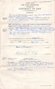 Bendigo Historical Society Inc.
Document - H. A. & S. R. WILKINSON COLLECTION: CONTRACT OF SALE
Contract of sale of land (Cash) dated 1st April, 1955 between Mr. H. N. Davenport (vendor) and Mr. H. A. J. Smith (purchaser)organization, business, h.a. & s.r wilkinson real estate -
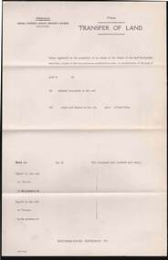 Bendigo Historical Society Inc.
Document - CAMBRIDGE PRESS COLLECTION: TRANSFER OF LAND
Draft Transfer paper for the Transfer of Land. Messrs. Tatchell, Dunlop, Smalley & Balmer, Solicitors. Part printed date of 192-. Cambridge Press, Print, Bendigo.business, printers, cambridge press, cambridge press collection, draft transfer, tatchell dunlop smalley & balmer, transfer of land, cambridge press -
Port Melbourne Historical & Preservation Society
Photograph - Group of people looking at bottom halves of two cranes from Station Pier on land under West Gate Bridge, 2012
Coloured photograph of six (6) people and a child looking at bottom halves of two Station Pier cranes . Location is land under West Gate Bridge.west gate bridge, built environment - industrial, engineering, piers and wharves - station pier, cranes, margaret bride, glen cosham, jim power, graham bride -
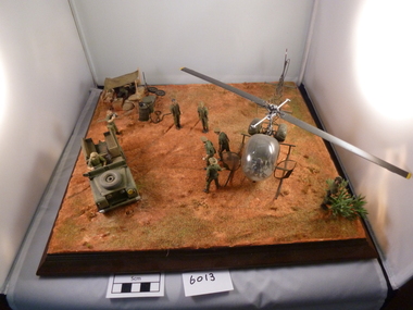 National Vietnam Veterans Museum (NVVM)
Model - Diorama, inspection with Sioux helicopter
Model of Sioux helicopter landed with senior officers to inspect gun emplacement. The pilot is attending to business outside the aircraft. Nine people, Land Rover and photographersioux (helicopter), vehicles, military, model, diorama -
 National Vietnam Veterans Museum (NVVM)
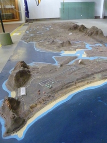
Map - Map, Relief, PHU
Raised relief map of Phuoc Tuy province. Six pieces showing land features from Long Hai hills to coast at Vung Tau baserelief map, phuoc tuy -
Port Melbourne Historical & Preservation Society
Document - Notice, Land auction, Williamstown Road to Plummer Street, Port Melbourne, R Holden Stone, Borough Surveyor Brighton and Port Melbourne, Mar 1887
Large auction notice advertising sale of land Williamstown Road to Plummer Street 19.3.1887, with general (distorted) plan of Port Melborne and a larger plan of the allotmentstown planning, fishermans bend, land sales -
Whitehorse Historical Society Inc.
Map, A Plan of part of the Parish of Nunawading, 1984
Hand drawn plan showing the owners or occupiers of land c1860'.Hand drawn plan showing the owners or occupiers of land c1860'. Includes proposed townships of New Brunswick and Norwich. Scate 1 inch : 10 chains.Hand drawn plan showing the owners or occupiers of land c1860'. maps, shire of nunawading -
Whitehorse Historical Society Inc.
Document, Victorian Government Gazette
Pages from Victorian Government Gazette from 1867 to 1887, describing parcels of land in Nunawading reserved for such purposes as parks, experimental and botanic gardens and cemetery.Pages from Victorian Government Gazette from 1867 to 1887, describing parcels of land in Nunawading reserved for such purposes as parks, experimental and botanic gardens and cemetery.Pages from Victorian Government Gazette from 1867 to 1887, describing parcels of land in Nunawading reserved for such purposes as parks, experimental and botanic gardens and cemetery.nunawading, parish of nunawading -
 Whitehorse Historical Society Inc.
Letter - Correspondence, Arlington, Blackburn Road, 26/04/1986 12:00:00 AM
Letter describing use of land 'Arlington',Letter describing use of land 'Arlington', Canterbury Road, Blackburn. Purchased in [1936] as a poultry farm and subdivided in 1947 into 7 shops and 5 building blocks.Letter describing use of land 'Arlington',pooley, beatrice, fred, arlington, canterbury road, blackburn south, land subdivision -
 Whitehorse Historical Society Inc.
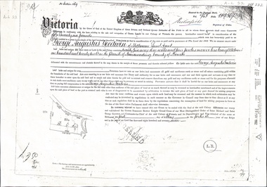
Document - Land Title, Certificate of Title, 01/05/1877
Certificate of Title issued to George Augustus Goodwin issued in 1877 for land adjacent to Dandenong Creek. Also copies of mortgages and eventual transfer to Annie Goodwingoodwin, george augustus, edwards, annie, dandenong creek, land settlement -
Whitehorse Historical Society Inc.
Document, Forty years takes the cake, 30/04/2008 12:00:00 AM
Strathdon Community, built on land donated by Mary Matheson, celebrated 40 years on the site.Strathdon Community, built on land donated by Mary Matheson, celebrated 40 years on the site. A cake was cut by Marny Miller, Mrs Matheson's daughter (Photo)Strathdon Community, built on land donated by Mary Matheson, celebrated 40 years on the site. strathdon community, matheson, mary, miller, marny, batten, robyn, edmiston, june -
 Whitehorse Historical Society Inc.
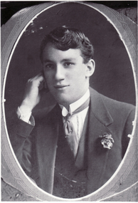
Photograph - Black & white photo, Samuel Graham Davidson
Black and white photo of Samuel Graham Davidson, Born 4/5/1896, Land Owner and Resident Whitehorse Road, Simla and King Streets, Blackburn.davidson, samuel graham, landowner, blackburn -
 Whitehorse Historical Society Inc.
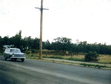
Photograph, Old Orchard Shopping Centre Blackburn North, 10/11/2010 12:00:00 AM
The Old Orchard Shopping Centre was completed by October 1965Coloured photograph of land on the eastern side of Springfield Road being cleared for the building of the Old Orchard Shopping Centre. Station wagon on left. Pole in centre.old orchard shopping centre, blackburn shopping centres -
 Bendigo Historical Society Inc.
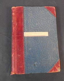
Administrative record - Lands Office Bendigo - Exemptions and Applications
Blue and red hardcover book containing pages of handwritten entries of exemptions and applications to purchase land at various places. The book covers the years 1937 to 1939."Exemptions and Applications" handwritten on label on front cover. Attendance, Lands & Survey in gold letters on the spine.land office, government, land purchases -
 Kew Historical Society Inc
Map, Real Estate Map of Bulleen, Templestowe, Lower Templestowe, Doncaster, North Balwyn
A large undated printed map of Bulleen, Templestowe, Lower Templestowe, Doncaster, North Balwyn showing major and minor roads, waterways and proposed facilities in this area of Melbourne.A useful if undated real estate map that allows viewers to compare current and historic aspects of these areasMap of Bulleen, Templestowe, Lower Templestowe, Doncaster, North Balwyn used by JB Thomson & Co, Real Estate Agents, to identify and record land sales on these. There are some markings on the plan indicating the location and price of lots.subdivision plans, bulleen, templestowe, lower templestowe, doncaster, north balwyn -
Federation University Art Collection
Work on paper - Digital Prints, Gilson, Deanne, 'Wadawurrung Axe Heads 1-4' by Deanne Gilson, 2011
Dr Deanne GILSON (1967- ) Country: Wadawurrung Deanne Gilson is a Federation University alumni, and an award-winning multi-disciplinary artist. Her practice draws its inspiration from ‘Ancestral marks’ and design on cultural objects found in museum archives and family oral histories. Deanne’s practice seeks to interrogate the colonial legacy of settlement and the western hegemonic systems of class, race and representation in historical photographs that were imposed on her Ancestors. Her work also explores the matriarchal role through her feminist perspectives, looking at the history of marriage and the oppressive function it has played within her family. Deanne has completed the following educationala achievements. 2014 – 2015 Masters by Research (Visual Art), Deakin University Geelong 2013 Graduate Diploma in Education Secondary, Federation University 2011 Certificate IV in Aboriginal Contemporary Art & Craft 2010 Cultural Heritage Management Course, Lakes Entrance 1 Week 2007 – 2010 Graduated, Bachelor of Visual Arts with Honours, University of Ballarat 1984 Diploma of Art, School of Mines & Industries TAFE This item is part of the Federation University Art Collection. The Art Collection features over 2000 works and was listed as a 'Ballarat Treasure' in 2007.This work depicts an axehead found on Wadawurrung country and is a responce to workign alongside archeologists untertaking land surveys of her ancestral lands and the visual documentaiton of artefcts.art, artwork, deanne gilson, gilson, wadawurrung, stone axe, aboriginal, alumni -
University of Melbourne, Burnley Campus Archives
Poster, Nursery Display and Self Guided Tour, 1997-2007
nursery, exhibition, display, tour, university of melbourne, land & food resources - burnley -
University of Melbourne, Burnley Campus Archives
Poster, The University of Melbourne, Nursery Display and Self Guided Tour, 1997-2007
university of melbourne land & food resources, nursery, display, exhibition -
University of Melbourne, Burnley Campus Archives
Plan, Burnley College Faculty of Agriculture Forestry and Horticulture
site plan -
 Bendigo Historical Society Inc.
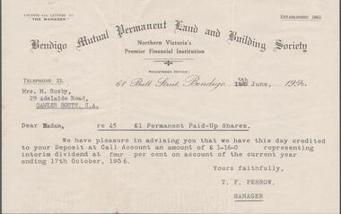
Financial record - EDWIN BUCKLAND COLLECTION: DIVIDEND STATEMENT
Dividend statement from the Bendigo Mutual Permanent Land and Building Society issued on the 5th, June 1956 to Mrs. M. Rusby of Gawler South SApaid up shares, bendigo mutual permanent land & building society