Showing 8323 items
matching the bridge
-
 Glenelg Shire Council Cultural Collection
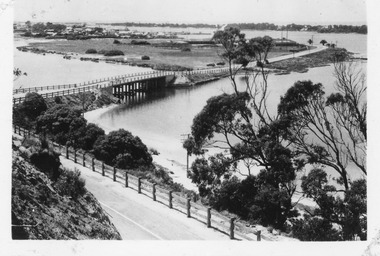
Photograph, Bridge Construction, 13/05/1958
Port of Portland Authority ArchivesFront: Back- '13 May 1958'- purple stampport of portland archives -
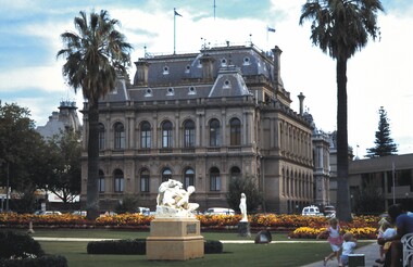 Bendigo Historical Society Inc.
Slide - BENDIGO & EASTER FAIR, 1990
Conservatory Gardens, crn Bull and Bridge sts, Bendigo. Bendigo Law Courts in back ground, Police Station to the right and the Shamrock to the left. 1990.slide, bendigo, conservatory gardens, conservatory gardens, bendigo -
Port Melbourne Historical & Preservation Society
Photograph - Bridge United Cricket Club, 1939 and South Melbourne CYMS Football Team, 1939 - 1946
Donated to PMH&PS by Pat HARPERTwo black and white photographs .01 - Bridge United Cricket Club team 1939 .02 - South Melbourne CYMS football team 1946sport - australian rules football, sport - cricket, gerry harper -
 Port Melbourne Historical & Preservation Society
Photograph - 207 Ross Street, Port Melbourne, Glen Stuart, 2005
three colour photos of 207 Ross St (corner of Bridge St) being redeveloped from a corner shop with residence to just residential.2005built environment - domestic, ross street -
Port Melbourne Historical & Preservation Society
Photograph - Waiting room, western finger pier, Station Pier, Port Melbourne, Alison Kelly, c. 1990
Colour photograph of waiting room for paddle steamer, western finger pier, Station Pier, with views of seaward beacon and West Gate Bridge, 1990piers and wharves - station pier, beacons, west gate bridge, alison kelly, leading lights -
Port Melbourne Historical & Preservation Society
Badge - Port Melbourne Bowling Club, A J Parkes, c. 1975
Collected by Fred WINDUSSPort Melbourne Bowling Club badge, design in navy blue, red, gold and aquamarine appears to be Yarra and West Gate Bridge; irregular shapesocieties clubs unions and other organisations, sport - lawn bowls, frederick robert winduss, port melbourne bowling club -
Port Melbourne Historical & Preservation Society
Photograph - Demolition debris, Bayside site, Port Melbourne, David Thompson, 1991
One of four photos taken by David Thompson of demolition debris on the Bayside site: View to Melbourne, close up, with debris from Centenary BridgeDescription in aqua ink on backdemolitions -
Port Melbourne Historical & Preservation Society
Photograph - Southern pedestrian stairway, Centenary Bridge, Viva, 1989
Black and white photo taken 1989 by 'Viva', an artist from the Mission Arts Centre: southern pedestrian stairway to Centenary Bridge,side viewengineering - bridges, centenary bridge, viva - artist -
 Port Melbourne Historical & Preservation Society
Photograph - Mandalay',163 Bridge Street, Port Melbourne, Pat Grainger, Mar 1998
Proposal to demolish and develop two 2 storey houses on the site were taken to Administrative Appeals Tribunal by neighbours and PMH&PS members, December 1997. Appeal was lost.Small colour photo of 163 Bridge Street ('Mandalay') Feb 1998 after it had been approved for demolition for the building of two town housesbuilt environment - domestic, mandalay, bridge street -
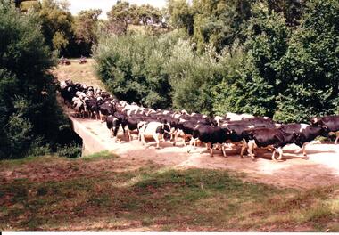 Hume City Civic Collection
Photograph, c late 1980s
The series of photographs show a number of sites included in the Rupertswood Estate. By 1851 William Clarke had acquired 31,375 acres of land in the Sunbury district. The foundation stone for Rupertswood Mansion was laid on 29th August 1874 by Mrs. W. J. Clarke, daughter-in-law of 'Big Bull'. The Salesian Fathers bought the Rupertswood property in June 1927 and established Salesian College.A coloured photograph of a herd of Fresian cows crossing a small bridge on the Rupertswood Estate. The cows were from the agricultural studies faculty at Salesian College.rupertswood estate, clarke, william j. t. 'big bull', salesian brothers, george evans collection -
 Clunes Museum
Photograph - PHOTOGRAPH POSTCARD, 1968
POST CARD SENT TO THE BLACKBAND FAMILY FROM THE HANCOCK FAMILY.POST CARD SENDING GREETINGS FROM CLUNES DEPICTING THE TOWN HALL, THE BRIDGE, THE ANGLICAN CHURCH, THE POST OFFICE, THE MAIN STREET, THE LIBRARY AND THE FORD.GREETINGS FROM CLUNES.photographs, town hall, post office., postcard, 1968 -
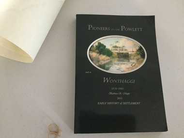 Wonthaggi & District Historical Society
Book and Map, Barbara Moyle, Pioneers on tthe Powlett and at Wonthaggi 1878-1910, 2015
Book - families social histories, maps, photograps Map - block numbers town names physical / geographical featuresFarming and social history of pioneers of the Powlett River are prior to the establishment of the State Coal Mine at Wonthaggi. Significant land marks, buildings and photographs are included. Dark green cover with oval artists impression of Powlett river and bridge Associated map which covers the parishes plus key places of interestlPioneers on the Powlett and at Wonthaggi 1878-1910 Barbara R Moyle 2015 Early History of Settlement Map - Parish names, significant sitesfarming, pioneers of wonthaggi and district, wonthaggi families -
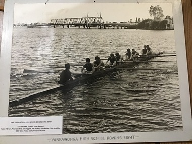 Yarrawonga and Mulwala Pioneer Museum
Photograph, Yarrawonga High School Rowing Eight, 1968
The high school had a very active rowing group supported by the Yarrawonga Rowing Club. Boys in photo Cox - Earl Pike, Stroke - Peter Bennett, Peter O’Bryan, Peter Langford, Ian Doggett, Jeff McKee, John Baillie, Colin McMillan, Bow - Brian Fields Coach - Andrew Ruwolt Black and white photograph mounted on board of YHS Rowing eight taken on Mulwala side of Lake Mulwala above the road traffic bridge 1968Yarrawonga High School Rowing Eight -
Whitehorse Historical Society Inc.
Article, Uni Bridge battle begins, 2015
For more than a decade, Deakin University has tried to have a bridge built across Gardiners Creek Reserve to link its two campuses.For more than a decade, Deakin University has tried to have a bridge built across Gardiners Creek Reserve to link its two campuses.For more than a decade, Deakin University has tried to have a bridge built across Gardiners Creek Reserve to link its two campuses.city of whitehorse, deakin university, burwood campus, west of elgar residents' association, gardiners creek reserve -
![Letter from L. Bagley to [John] Williams, dated 16 January 1924](/media/collectors/56f368632162f118acbff12e/items/60d923316e5f99545134e8e3/item-media/614129c8eb4a115f1bcdae79/item-fit-380x285.jpg) Whitehorse Historical Society Inc.
Whitehorse Historical Society Inc.Legal record - Correspondence, Williams' Road Bridge, 16/01/1924 12:00:00 AM
Letter from L. Bagley to [John] Williams, dated 16 January 1924Photocopy of letter from L. Bagley to [John] Williams, dated 16 January 1924 regarding bridging a creek in order to form Williams Road.Letter from L. Bagley to [John] Williams, dated 16 January 1924 bagley, l, williams, john, williams road, blackburn, land subdivision -
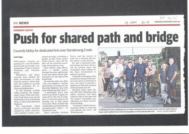 Whitehorse Historical Society Inc.
Article, Shared Path And Bridge, 2018
Whitehorse and Knox councils are lobbying the State Government to help fund a shared path and bridge over Dandenong Creek to connect Wantirna and Vermont South.dandenong creek, vermont, wantirna, city of whitehorse, vicroads, bridges, cycling, pedestrian overpass -
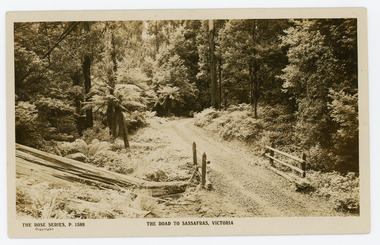 Mt Dandenong & District Historical Society Inc.
Photograph, The Road to Sassafras. Victoria
Rose Series postcard # P. 1588 showing a view of the road to Sassafras pre WW1.Sepia Coloured Rose Series post card P.1588 showing a stretch of unmade road passing over a simple bridge on the road to sassafras.On Front: THE ROSE SERIES, P. 1588 THE ROAD TO SASSAFRAS, VICTORIArose series, postcard, sassafras, road -
 Lilydale RSL Sub Branch
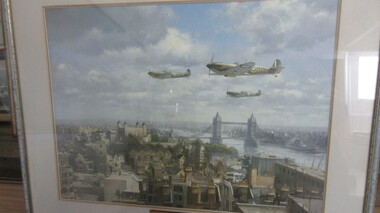
Print - Framed Print, Spitfires over London
Framed print of painting by John Young entitled "Spitfires over London" showing three Spitfires flying over London with Tower Bridge in the background.Inscribed plaque reads " SPITFIRES OVER LONDON BY JOHN YOUNG PRESENTED TO LILYDALE RSL BY GORDON ANDERSON 1997. -
 City of Kingston
Photograph - Colour, 1998
The name Mordialloc was derived from the name Moody Yallock, which comes from the Bunurong language. The Bunurong Peoples are the Traditional Owners of this area. The name means “high water” or “high creek”. In 1839, colonial authorities declared the mouth of the creek, and an additional 830 odd acres as an Aboriginal Reserve, although this proclamation was never gazetted. The reserved land included part of the Carrum Carrum Swamp which was abundant with wild life and natural resources. Regular encroachments, including land sales which began in 1863, were made on the land until 1878 when the Reserve was declared closed, and the land was opened up to land sales. Market gardening and suburban house lots quickly began to develop, and Mordialloc became a renowned picnic and holiday site. Mordialloc Creek is a popular bay side destination for local and visitors, and is a site for boating, kayaking, fishing and swimming, along with many other activities.Colour photograph of Mordialloc Creek, looking inland.Small fishing and leisure boats are moored on either side of creek, with a view of the Mordialloc Bridge Hotel in the background.mordialloc, bunurong, traditional owners, suburbs, boats, fishing, waterways, hotel -
 Bendigo Historical Society Inc.
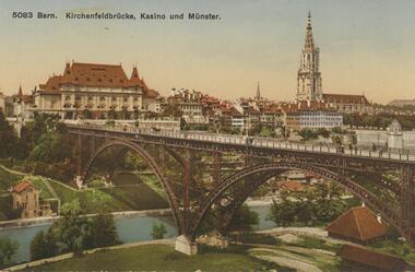
Postcard - ROY AND DORIS KELLY COLLECTION : 5083 BERN KIRCHENFELDBRUCKE, KASINO UND MUNSTER, 1900-1920
Postcard, coloured photo of a part of the Swiss city of Bern showing the iron Kirchenfeld bridge over the Aare river. In the background is the Casino and the Bern Cathedral.postcard, photograph, postcard, bern, switzerland, kirchenfeld bridge -
Port Melbourne Historical & Preservation Society
Photograph - Sandridge Lagoon, pre WWI, 1900s
Black and White photograph of Sandridge Lagoon taken from the Rouse Street Bridge pre WWI. Small craft and Harpers Starch Factory are visiblepiers and wharves - lagoon pier, harpers starch factory, sandridge lagoon -
 Lakes Entrance Historical Society
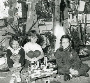
Photograph - Lakes Entrance Primary School, Lakes Post Newspaper, 1994
Black and white photograph of primary school students Aleisha Burnett, Melanie McPhee and Megan McKenzie, making a Lego bridge Lakes Entrance Victoria.schools, activities -
 Clunes Museum
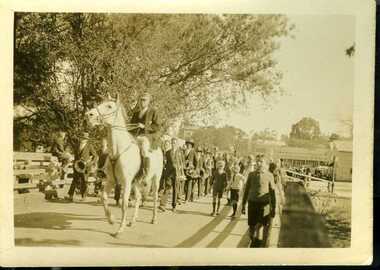
Photograph, HARRINGTONS, 1939
PHOTOGRAPH OF CLUNES EASTER CENTENARY 1939.0RIGINAL PHOTOGRAPH OF PARADE LED BY MR. ANDREW McLENNAN ON WHITE HORSE - LEADING MARCHERS OVER BUTTER FACTORY BRIDGE , FRASER STREET IN BACKGROUND.local history, photography, photographs, events and celebrations, back to clunes -
 Lakes Entrance Historical Society
Postcard - Lakes Entrance, Bulmer, H D, 1940c
One Black and White Photograph 6.5 x 11|Two Postcard 8.5 x 14|Two Small format postcard 6 x 9|This is the before paired photograph used in the 150 year, Lakes Entrance 1858-2008 display.|The after paired photograph number is 01156.1 Also one 12 x 16 framed photograph used in room display.Black and white photographic of bridge over North Arm showing the western end of township, sand hummock viewed in distance, Lakes Entrance Victoriatownship, bridges, room display -
 National Vietnam Veterans Museum (NVVM)
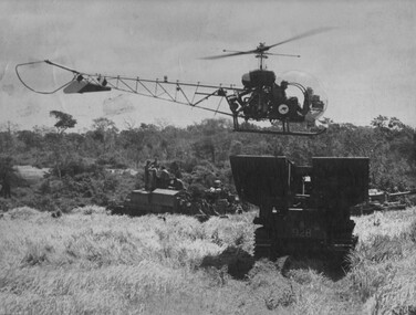
Photograph, Gibbons, Denis, Centurion Landing Zone
Denis Gibbons (1937 – 2011) Trained with the Australian Army, before travelling to Vietnam in January 1966, Denis stayed with the 1st Australian Task Force in Nui Dat working as a photographer. For almost five years Gibbons toured with nine Australian infantry battalions, posting compelling war images from within many combat zones before being flown out in late November 1970 after sustaining injuries. The images held within the National Vietnam Veterans Museum make up the Gibbons Collection. A black and white photograph of a helicopter of 161 (Indep) Recce Flt uses a Centurian Tank Bridge Layer as a landing zone during Operation Matildaphotograph, centurion tank, operation matilda, gibbons collection catalogue, 161 recce flight, centruian bridgelayer, denis gibbons -
 Bendigo Historical Society Inc.
Photograph - BASIL MILLER COLLECTION: CHARING CROSS BRIDGEWORK
Black and white photo showing works being undertaken on bridge at Charing Cross. Number 'C922' stamped on back of photo. There are two copies of this photo.basil miller, bendigo trams -
 Lakes Entrance Historical Society
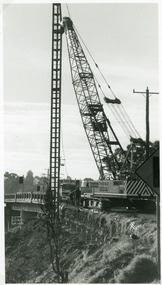
Photograph - Bridges, Lakes Post Newspaper, 1995
Image appeared in Lakes Post Newspaper 7 June 1995Black and white photograph showing Whelans crane starting work on the approaches to the Swan Reach bridge, for widening and strengthening works. Swan Reach Victoriabridges, machinery, maintenance -
Lakes Entrance Historical Society
Book, Woodhouse Sharon, Draft Management Plan, Cossticks Weir, Trestle Bridge, 1995
Research and interpretation of Cossticks Weir and Trestle Bridge, in the Colquhoun Forest, East Gippsland, suggested management startegies for the sites, flora and fauna, and control ferals.transport, bridges, settlement -
Lakes Entrance Historical Society
Book, LERHS, Perry Bridge Area Information
Information on Starthfieldsaye Perry Bridge area including settlers William Obell Raymond Doctor Disher and reverend Doctor Hagenaurer Lakes Entrance Victoriasettlers, aboriginals -
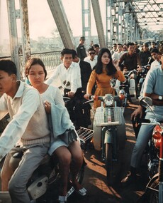 National Vietnam Veterans Museum (NVVM)
Photograph, Gibbons. Denis, Hue Traffic Jam
Denis Gibbons (1937 – 2011) Trained with the Australian Army, before travelling to Vietnam in January 1966, Denis stayed with the 1st Australian Task Force in Nui Dat working as a photographer. For almost five years Gibbons toured with nine Australian infantry battalions, posting compelling war images from within many combat zones before being flown out in late November 1970 after sustaining injuries. The images held within the National Vietnam Veterans Museum make up the Gibbons Collection.A coloured photograph of Hue, South Vietnam, Circa 7th Dec 1968. A traffic jam on the bridge over the Perfume River at Hue leading to the city. photograph, hue, gibbons collection catalogue, perfume river, denis gibbons