Showing 11032 items matching " land"
-
 Phillip Island and District Historical Society Inc.
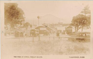
Photograph - Post Card, Early 1900's
One of 17 photographs donated by Olive BlameySepia postcard looking towards the Cowes Pier. Cars and people in the foreground. Jetty shed at the left of the pier and small building to the right. People on the pier with yachts moored and sailing."The pier at Cowes, Phillip island." "Valentine, M 5820." Letter on back from Freda to Jean explaining where they land at Phillip Island and how to get to their place.cowes pier phillip island, cowes jetty, cowes jetty foreshore, phillip island, olive blamey -
 Ringwood and District Historical Society
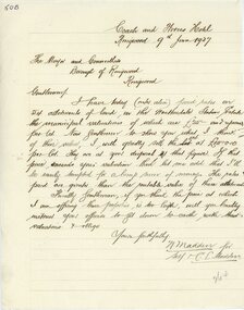
Letter, Letter from N Madden to Mayor and Councillors , Borough of Ringwood. 1937
Hand written letterLetter is from N.Madden -Coach and Horses Hotel, to the Ringwood Borough Council, dated 9th June 1937. Contents regarding Allotments of land in the Heatherdale Station Estate. -
 Ringwood and District Historical Society
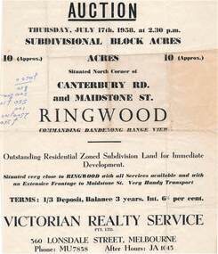
Flyer - Land Auction Sale, Ten Acres, Maidstone Street Ringwood - 1958
Double sided page advertising Auction, Thursday, July 17th, 1958, (Approx.) 10 Acres, north corner of Canterbury Road and Maidstone Street, Ringwood. Agents - Victorian Realty Service Pty.Ltd., 360 Lonsdale Street, Melbourne, Phone MU7858, After Hours JA1045. Reverse side shows map of proposed subdivision by K.J. Noonan & Co., Surveyors & Engineers, 495 St.Kilda Rd, Melbourne, marked subject to approval of all interested statutory authorities.Residential zoned subdivision land for immediate development. Extensive frontage to Maidstone Street. Accompanying handwritten annotation "10 acres offered as a whole, later re-subdivided". -
 Federation University Historical Collection
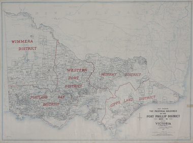
Plan, Map Showing the Pastoral Holdings of the Port Phillip District 1835-1851 Now Victoria, 1932, 1932
Another name for Pastoral Holdings is squatting runs. Information on Alfred Stephen Kenyon of the Historical Society of Victoria can be found at http://adb.anu.edu.au/biography/kenyon-alfred-stephen-6936/text12035 Map of Victoria showing the boundaries of the Port Phillip District (Victoria) pastoral boundaries. pastoral holdings, squatters, squatting, victoria, land, crown lands, a.s. kenyon, alfred stephen kenyon -
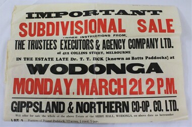 Wodonga & District Historical Society Inc
Poster - Hamilton-Smith Collection Wodonga Subdivision Poster
The Hamilton-Smith collection was donated by the children of Grace Mary Hamilton-Smith nee Ellwood (1911-2004) and John Hamilton-Smith (1909-1984) who settled in Wodonga in the 1940s. The Ellwood family had lived in north-east Victoria since the late 1800s. Grace’s mother, Rosina Ellwood nee Smale, was the first teacher at Baranduda in 1888, and a foundation member of the C.W.A. Rosina and her husband Mark retired to Wodonga in 1934. Grace and John married at St. David’s Church, Albury in 1941. John was a grazier, and actively involved in Agricultural Societies. The collection contains significant items which reflect the local history of Wodonga, including handmade needlework, books, photographs, a wedding dress, maps, and material relating to the world wars. This item has well documented provenance and a known owner. It forms part of a significant and representative historical collection which reflects the local history of Wodonga. It contributes to our understanding of social and family life in early twentieth century Wodonga, as well as providing interpretative capacity for themes including local history and social history. A white poster with black and red text advertising a subdivision sale sale, subdivision, wodonga, land, building, development, hamilton-smith, hamilton-smith collection -
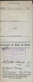 Bendigo Historical Society Inc.
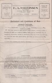
Document - H.A. & S.R. WILKINSON COLLECTION: CONDITION OF SALE
Contract of sale of land dated 16th November, 1954 between Mr. W.A. Haywood (seller) and Mrs A.E. Pendlebury for land situate corner Brown and Green Streets, Long Gully being allotment 500A section K described in residence licence 0943 129, together with 2-roomed cement brick dwelling and all sundry, also electric copper and cement troughs, concrete mixer and concrete moulds. Price 450 pounds.organization, business, h.a. & s.r wilkinson real estate -
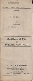 Bendigo Historical Society Inc.
Document - H.A. & S.R. WILKINSON COLLECTION: CONDITION OF SALE
Conditions of sale by private contract dated 20th May, 1943 between A.E. Cowling (seller) and H. Rice (buyer) for land situate Wood Street, Long Gully having a frontage of 150 links to Wood Street by a depth of 200 links and being the land described in right to occupy residence area title No. 4719 due 23/08/1943, together with 5-roomed weatherboard dwelling and all sundry. Price 225 pounds.organization, business, h.a. & s.r wilkinson real estate -
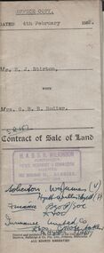 Bendigo Historical Society Inc.
Document - H.A. & S.R. WILKINSON COLLECTION: CONDITION OF SALE
Contract of sale of land issued by H.A. Wilkinson and dated 4th February 1952 between Mr. E.J. Stirton (seller) and Mrs. G.B.R. Rodier (buyer) for land being allotment 12A section 49B, Parish of Sandhurst, City and County of Bendigo described in Crown grant volume 2580 folio 515907 situate No. 325 Barnard Street Bendigo together with 4-roomed weatherboard dwelling and all sundry. Price 880 pounds.organization, business, h.a. & s.r wilkinson real estate -
 Bendigo Historical Society Inc.
Document - H.A. & S.R. WILKINSON COLLECTION: CONDITIONS OF SALE
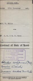
Contract of sale of land issued by H.A. Wilkinson and dated 20th November, 1952, between Mr. W. Mills (seller) and J.B. & E.F. Reid (buyers) land being part of Crown allotment 9 section 3S, Parish of Sandhurst, City and County of Bendigo described in certificate of title volume 5066 folio 1013160 situate No. 102 Wattle Street Bendigo, together with brick dwelling and all sundry. Price 2,585 pounds.organization, business, h.a. & s.r wilkinson real estate -
 Bendigo Historical Society Inc.
Document - H.A. & S.R. WILKINSON COLLECTION: CONDITION OF SALE
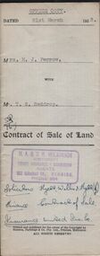
Contract of sale of land issued by H.A. Wilkinson dated 21st March 1953 between Mrs. M.J. Perrow (seller) and Mr. T. S. Reddrop for land being part of Crown allotments 7 and 8 section 77C, Parish of Sandhurst, City and County of Bendigo described in certificate of title volume 4356 folio 046 and situate No. 55 Gladstone Street Bendigo, together with weatherboard dwelling and all sundry. Price 1,350 pounds.organization, business, h.a. & s.r wilkinson real estate -
 Bendigo Historical Society Inc.
Document - H. A. & S. R. WILKINSON COLLECTION: CONTRACT OF SALE
Conditions of sale by private contract dated 18th November, 1947 between Mrs. A. A. Goodisson (vendor) and Mr. A. E. Stirton (purchaser). Property: land situate Lucan Street, Bendigo having a frontage of 33 feet by a depth of 165 feet, being part of allotment 35 section E, Parish of Sandhurst City of Bendigo, land described in conveyance No. 487 book 561, together with building and fence thereon. Price: 155 pounds.organization, business, h.a. & s.r wilkinson real estate -
 Bendigo Historical Society Inc.
Document - H. A. & S. R. WILKINSON COLLECTION: CONTRACT OF SALE
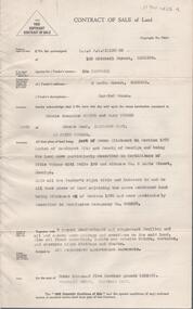
Contract of sale of land dated 2nd May 1957 between Mrs. I. Campbell (vendor) and Miss N. J. Schier - Mrs. M. Turner (purchaser). Solicitor for vendor: Hogan & Hogan. Solicitor for purchaser: Cohen, Kirby & Co. Property: land being part of Crown allotment 6A section 107C Parish of Sandhurst, City of Bendigo, described in certificate of title volume 6141 folio 189 and situate No. 5 Eadie Street -
 Victorian Aboriginal Corporation for Languages
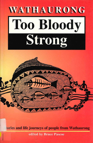
Book, Bruce Pascoe, Wathaurong : too bloody strong : stories and life journeys of people from Wauthaurong, 1997
Stolen children, stolen land, stolen freedom. Enough to break the strongest spirit but that?s what these people have got, they?re Too Bloody Strong to go under. The proud cry of survival is in all these stories and you can read the future in them to, From making baskets to building fences, from nursing to law, in education and art, the Wathaurong are preparing for the brand new day when the sun rises over a land of equality.maps, b&w illustrations, b&w photographswathaurong -
 Bendigo Historical Society Inc.
Document - JOHANSON COLLECTION: STATUTORY RELEASE TO ANNIE PENISTAN
Legal document. On front : dated 10th December 1887 Mrs Annie Penistan to the Bendigo Mutual Permanent Land and Building Society, Mortgage. On bottom of front page ' Motteram & Hyett Sandhurst. Mortgage for 300 pounds for allotment 10, section 80, Sandhurst. On back Dated 27th September 1904. The Bendigo Mutual Permanent Land and Building Society to Mrs. Annie Penistan. Statutory Release. On bottom 'Quick,Hyett & Rymer Bendigo'bendigo, land sales -
 Bendigo Historical Society Inc.
Document - MISS G ALICE JONES COLLECTION: ACCOUNT
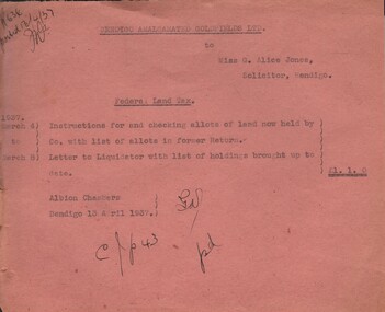
Bendigo Amalgamated Goldfields Ltd. To Miss G. Alice Jones. Re Federal Land Tax. Pink paper dated March 4 to March 8, 1937, and 13/4/1937. Instructions for and checking allots of land now held by Co. with list of allots in former Return, and letter to Liquidator with list of holdings brought up to date. Cost £1.1.0. R636 posted 13/4/37 written in the top left corner.the miss g alice jones collection - account, bendigo amalgamated goldfields ltd. -
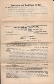
 Bendigo Historical Society Inc.
Document - H.A. & S.R. WILKINSON COLLECTION: CONTRACT OF SALE
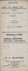
This business was owned by father and son, Henry Archibald Wilkinson and Samuel Ronald "Ron" Wilkinson. Henry (1882-1954) was born in Shepparton and died in Bendigo. He was married to Grace Hovendon in 1908. Samuel Ronald "Ron" (1914-1995), Henry's son, was married to Florence Jean McKerlie in 1937.Conditions of sale by private contract dated 4th August, 1936 between Executrix of the will of S.A. Burren Deceased (seller) and Mrs. E.M. Selkirk (buyer) for that piece of land situate No.317 McIntyre Street, Long Gully being the land described in residence area right No. 323, together with 4-roomed weatherboard dwelling and all sundry. Also all window blinds, curtains, linos on the floors and electric light fittings. Price 210 pounds.organization, business, h.a. & s.r wilkinson real estate -
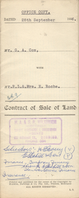 Bendigo Historical Society Inc.
Document - H.A. & S.R. WILKINSON COLLECTION: CONTRACT OF SALE
This business was owned by father and son, Henry Archibald Wilkinson and Samuel Ronald "Ron" Wilkinson. Henry (1882-1954) was born in Shepparton and died in Bendigo. He was married to Grace Hovendon in 1908. Samuel Ronald "Ron" (1914-1995), Henry's son, was married to Florence Jean McKerlie in 1937.Contract of sale of land dated 28th September, 1956 between G.A. Cox (seller) and Mr. R.L. & Mrs. E. Roche (buyer) for land being lot 1 on plan of subdivision No. 18242 part of Crown allotment 337 section E described in certificate of title volume 7132 folio 389 and situate no. 150 White Hills Road, Bendigo, together with 5-roomed brick dwelling and all sundry. Price 4,750 pounds.organization, business, h.a. & s.r wilkinson real estate -
 Kew Historical Society Inc
Plan - Subdivision Plan, Jas R Mathers Son & McMillan, East Kew Tramway Estate, 1915
Pru Sanderson, in her groundbreaking ‘City of Kew Urban Conservation Study : Volume 2 - Development History’ (1988), summarised the periods of urban development and subdivisions of land in Kew. The periods that she identified included 1845-1880, 1880-1893, 1893-1921, 1921-1933, 1933-1943, and Post-War Development. These periods were selected as they represented periods of rapid growth or decline in urban development. An obvious starting point for Sanderson’s groupings involved population growth and the associated economic cycles. These cycles also highlighted urban expansion onto land that was predominantly rural, although in other cases it represented the decline and breakup of large estates. A number of the plans in the Kew Historical Society’s collection can also be found in other collections, such as those of the State Library of Victoria and the Boroondara Library Service. A number are however unique to the collection.The Kew Historical Society collection includes almost 100 subdivision plans pertaining to suburbs of the City of Melbourne. Most of these are of Kew, Kew East or Studley Park, although a smaller number are plans of Camberwell, Deepdene, Balwyn and Hawthorn. It is believed that the majority of the plans were gifted to the Society by persons connected with the real estate firm - J. R. Mathers and McMillan, 136 Cotham Road, Kew. The Plans in the collection are rarely in pristine form, being working plans on which the agent would write notes and record lots sold and the prices of these. The subdivision plans are historically significant examples of the growth of urban Melbourne from the beginning of the 20th Century up until the 1980s. A number of the plans are double-sided and often include a photograph on the reverse. A number of the latter are by noted photographers such as J.E. Barnes.The East Kew Tramway Estate was a subdivision of two separate parcels of land between Adeney Avenue and Normanby Road. The larger section included 54 lots facing Adeney Avenue, Argyle Road, and Campbell, Hunter and Wishart Streets. [Hunter and Wishart Streets were created as part of the subdivision.] A further 17 allotments faced Normanby Road, Hubert and Campbell Streets. [The name of Hubert Street was later to be changed to Cecil Street.] The promotion of the sale referred to the advantages of living between two tram routes, in High Street and Cotham Road. On the plan, quaintly drawn trams mark these routes. Also on the plan is the route of part of the Outer Circle [Railway] Line.east kew tramway estate, subdivision plans - east kew -
 Warrnambool and District Historical Society Inc.
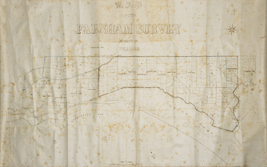
Map - Farnham Survey, 1850s
This is a map of the Farnham Special Survey. In 1843 William Rutledge purchased this Special Survey of 5,120 acres and named it Farnham. This Survey extended from Tower Hill to the Merri River at Dennington. The map appears to date from the 1850s This early map is of considerable significance as it shows details of the Farnham Special Survey. William Rutledge and his survey are important influences in the development of Warrnambool and district with the establishment of settlements at Killarney, Yangery and Tower Hill.A hand drawn map on waxed paper in brown, black and blue ink. It shows Armstrong's Bay, sea, Crown Land , the names of properties and some roads. It includes a compass direction diagram.farnham special survey -
 Marysville & District Historical Society
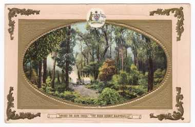
Postcard (item) - Colour postcard, Nicholas John Caire, "Amidst the Gum Trees." "The Bush Hermit, Marysville.", 1858-1918
A postcard of a photograph taken by socialite photographer Nicholas John Caire. N.J. Caire had a great love for the area and in the late 1800's took many photographs of Marysville and its surrounds.One of a series of postcards of photographs taken by socialite photographer Nicholas John Caire. N.J. Caire had a great love for the area in and surrounding Marysville and in the late 1800's took many photographs of Marysville and its surrounds. N.J. Caire was born in 1837 in Guernsey. He arrived in Adelaide about 1860 along with his parents who encouraged his early interest in photography. He opened a studio in Adelaide in 1867 after traveling extensively throughout the Gippsland taking photographs. After marrying in 1870 he moved to Talbot in Victoria until 1876 when he opened a studio in the Royal Arcade in Melbourne. After 1885 N.J. Caire gave up his city work and made his home in South Yarra and devoted the rest of his life to outdoor photography, specializing in the bush, the gullies and the mountains of south-eastern Victoria. POST CARD A.G.J. AFFIX/ STAMP THIS SPACE MAY BE USED/ FOR COMMUNICATION. THE ADDRESS ONLY TO BE/ WRITTEN HERE. Printed in Saxony COPYRIGHT. To Dear Emily/ With every loving/ Wish for many/ happy birthday/ with love from me/ Myrtlemarysville, victoria, george, george locke, nicholas john caire, cumberland valley, hermit, postcard, souvenir -
 Bendigo Military Museum
Print - PRINT, FRAMED
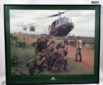
Caption under print. Soldiers of 5 Platoon, B Company, 7 RAR, preparing to board VS Iroquois helicopters during operation Ulmarrah, the cordon and search of Lang Phuoc Hai Village, South Vietnam, 26 August 1967". Members of 5 Platoon, B Company, 7th Battalion, The Royal Australian Regiment (7RAR), just north of the village of Lang Phuoc Hai, beside Route 44 leading to Dat Do. United States Army Iroquois helicopters are landing to take them back to Nui Dat after completion of Operation Ulmarra, the cordon-and-search by 7RAR of the coastal village of Lang Phuoc Hai. Operation Ulmarra was conducted by 2nd Battalion, The Royal Australian Regiment (2RAR) and 7RAR with support elements. Left to right: Private (Pte) Peter Capp (kneeling); Pte Bob Fennell (leaning over, facing camera, with an ammunition belt for an M60 machine gun slung over his shoulder); Corporal Bob D'Arcy (partly obscured behind Fennell); Pte Neal Hasted (centre, front); Pte Ian Jury (partly obscured, centre, rear, holding rifle); Pte Colin Barnett (front, right, M60 ammunition belt on back, back of head to camera); Lance Corporal Stan Whitford (partly obscured behind Barnett); the helicopter marshal at right is Pte John Raymond Gould, 7RAR. The United States Army Iroquois UH-1D helicopter was operated by 2 Platoon, 162nd Assault Helicopter Company, 11th Combat Aviation Battalion. (Having achieved almost the status of an icon, this image was chosen for, and is etched on, the Australian Vietnam Forces National Memorial on Anzac Parade, Canberra, ACT, dedicated in October 1992). Source AWM Print donated and dedicated to 3789179 FRANK FRIGERIO, 5 Platoon, B Company, 7RAR. See also Cat No. 3543-3549.3Print - coloured print of a photograph depicting three helicopters coming in to land above a dirt road with several groups of soldiers in uniform with jungle vegetation in the background. Frame - black painted metal.See in context, historical - caption under print.prints, framed, accessories, vietnam war -
 Glenelg Shire Council Cultural Collection
Photograph - Photograph - Main Breakwater Construction, n.d
Port of Portland Authority Archivesport of portland archives -
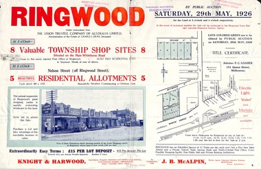 Ringwood and District Historical Society
Flyer, Township Shop Sites and Residential Allotments Sale By Public Auction, Ringwood, Victoria - 1926
Advertisement for eight township shop sites and five residential allotments for sale by Public Auction on the land in Ringwood on Saturday, 29th May, 1926, with location map, and summary of local features and services. Locality plan highlights sites for auction in Nelson Street, Seymour Street and Whitehorse Road. (Agents) Knight & Harwood, 315 Collins Street, Melbourne, Phones 10615, 10616 Central, in conjunction with J.B. McAlpin, Estate Agent, Opposite Railway Station, Ringwood, Phone Ringwood 7. -
Glenelg Shire Council Cultural Collection
Photograph - Photograph - Portland town and Portland Harbour, 1957
Port of Portland Authority ArchivesBack: Top right - 1957 in black biro.port of portland archives, portland harbour -
Glenelg Shire Council Cultural Collection
Photograph - Photograph - Main Breakwater construction, Portland, Jun-54
Port of Portland AuthorityBack: PHT Stamp - Print No /4.37 Neg 253 Date Taken 1/6/54 SUBJECT RECLAMATION BEHIND RUBBLE BANKport of portland archives, main breakwater, construction, harbour development -
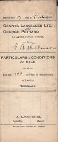 Bendigo Historical Society Inc.
Document - H.A. & S.R. WILKINSON COLLECTIONCONDITION OF SALE
Particulars & conditions of sale of lot no. 188 on plan of subdivision of land at Robinvale between Dennys Lascelles Ltd + George Pethard as agents for the vendor and H. A. Wilkinson (buyer). Price 63 pounds.organization, business, h.a. & s.r wilkinson real estate -
 Bendigo Historical Society Inc.
Document - H.A. & S.R. WILKINSON COLLECTION: CONDITION OF SALE
Conditions of sale by private contract dated 14th. December, 1928 between G. J. Wilkinson and M. Berry for land at corner Creek and Haman Streets Bendigo. The contract is marked Cancelled.organization, business, h.a. & s.r wilkinson real estate -
Bendigo Historical Society Inc.
Map - TOWNSHIP OF SANDHURST MAP
Map township of Sandhurst Portion B Bendigo Creek. Victoria zincographed at the Crown land's office, nos 54/21-57/12 Melbourne, April 21st 1857 (by G. Collis). -
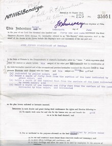 Bendigo Historical Society Inc.
Document - MCCOLL, RANKIN AND STANISTREET COLLECTION: EAST CLARENCE GOLD MINING CO - LEASE 11161, 1941
Document; East Clarence Gold Mining Co - Lease 11161. Lease document for Crown Land No. 11161 Bendigo. Includes plan of lease area Whipstick Road Eaglehawk. No. 11161 Bendigo.MCCOLL RANKIN & STANISTREETorganization, business, gold mining lease, mccoll rankin & stanistreet -
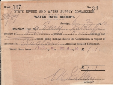 Bendigo Historical Society Inc.
Document - FRANK J EVERY COLLECTION: INVOICE THE BENDIGO DISTRICT LAND AND ESTATE AGENCY
Invoice issued to Mr F. Every on February 7, 1912 by the Bendigo District Land & Estate Agency (246 Hargreaves Street) for 17 items totalling: 28 pounds and 12 shillings.business, retail, land & estate agency