Showing 10388 items
matching plan
-
 University of Melbourne, Burnley Campus Archives
Plan - Sketch, School of Horticulture -Burnley, Pre 1980
Hand drawn sketch plan of placement of trees to the N.E., E. and S.E. of the Principal's Residence also showing placement of buildings, paving, lawns and paths.buildings, paving, lawns, burnley school of horticulture, principal's residence -
 Whitehorse Historical Society Inc.
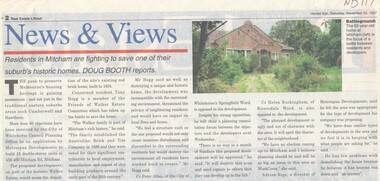
Article, Walker Estate, 22/11/1997 12:00:00 AM
Luther College Year 10 History assignment Residents in Mitcham are fighting to save one of their suburb's historic homes.Residents in Mitcham are fighting to save one of their suburb's historic homes. More than 60 objections have been received by the City of Whitehorse Planning Office to an application by Metrospan Developments to build 16 double storey units at 456 - 460 Mitcham Road, Mitcham. The proposed development is on part of the historic Walker Estate.Luther College Year 10 History assignment Residents in Mitcham are fighting to save one of their suburb's historic homes. walker estate, hogg, tony, australian tesselated tile co. pty ltd, allan, peter, buckingham, helen, rigo, anthony, metrospan developments -
 Federation University Historical Collection
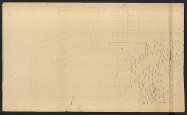
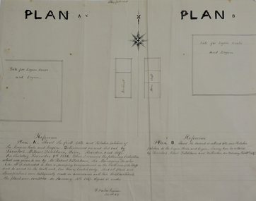
Plans, Site for Engine House and Engine, 1887
Two ink plan drawings, one with brown and grey shading, showing proposed sites and relative positions for an engine house and engine. .1) shows Plan A and Plan B options .2) shows elevations of brick engine houseengine house, robert ditchburn, w. watson, plans, mining -
 Port Melbourne Historical & Preservation Society
Book, Making the Most of the Bay, Apr 1989
'Making the Most of the Bay'- a draft plan for the protection and development of Port Phillip and Corio Bays, 1989. A draft plan to guide decision making. Introduction by Tom Roper, Minister for Planning and Development. (Refer item 1048, final version)state government victoria, natural environment - conservation, town planning -
 Melbourne Tram Museum
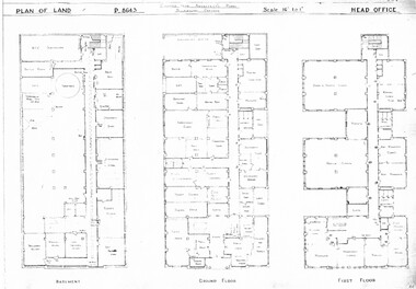
Drawing, Melbourne & Metropolitan Tramways Board (MMTB), "Head Office", c1938
Set of three photocopied plans or drawings on A3 sheet of "Head Office" - c1937 .1 - P8643 - Plan showing Basement, Ground Floor and First Floor - shows MCC substation location in basement. .2 - P8644 - Plan showing Second, Third and fourth floors .3 - P8394 - Plan showing firth floor and roof, with lift rooms.trams, tramways, drawings, depots, property, head office, mmtb, substation -
Kew Historical Society Inc
Plan - 30 Choice Home Sites in Kilby Road, Meldrum Street and Fairway Drive, 1965
Subdivision plans and real estate flyers/brochures reveal a number of aspects of urban development and history. The Kew Historical Society's collection of these plans, as well as advertisements extracted from magazines, cover key aspects of community development and architectural history of Kew and Kew Eat as well as surrounding suburbs. While most of the plans in the collection were gifted to the Society by the former City of Kew, a number of other plans and advertisements have been donated by individuals, of which this is an example.Original 4-page, bifold brochure, one of two in the collection, of home sites created following the creation of the Eastern Freeway which separated a section of land owned by the Kew Golf Club from the main course. The new estate featured 30 lots in Meldrum Street, Kilby Road and Fairway Drive. subdivisions -- kew east (vic.), subdivisions -- kew (vic.), kew golf club -
Kew Historical Society Inc
Plan - 30 Choice Home Sites in Kilby Road, Meldrum Street and Fairway Drive, 1965
Subdivision plans and real estate flyers/brochures reveal a number of aspects of urban development and history. The Kew Historical Society's collection of these plans, as well as advertisements extracted from magazines, cover key aspects of community development and architectural history of Kew and Kew Eat as well as surrounding suburbs. While most of the plans in the collection were gifted to the Society by the former City of Kew, a number of other plans and advertisements have been donated by individuals, of which this is an example.Original 4-page, bifold brochure, one of two in the collection, of home sites created following the creation of the Eastern Freeway which separated a section of land owned by the Kew Golf Club from the main course. The new estate featured 30 lots in Meldrum Street, Kilby Road and Fairway Drive.subdivisions -- kew east (vic.), subdivisions -- kew (vic.), kew golf club -
 Ringwood and District Historical Society
Manual, Southwood Primary School, Ringwood - Evacuation Procedure Manual (undated - circa - post 1983)
Bound Manual describing evacuation and emergency procedures. Includes Action Plan, Staff members, Instructions, Types of Threats and school building plan -
Lara RSL Sub Branch
Education Package, Anzac Centenary Corcmmunity Resource Guide
The Community Resource Guide helps you plan a commemorative event in Victoria and share Local stories as part of the planning for ANZAC Centenary celebrationsPart 1 includes elements of a commemorative service and preserving precious memorabilia Part 2 includes Victoria's roll in the History of World War One. Also included are capsule stories of the men who were awarded the Victoria Cross for outstanding valour -
 Federation University Historical Collection
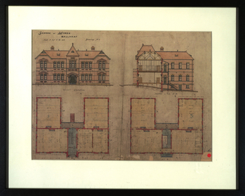
Drawing - Architectural Drawing, Plans for the Ballarat School of Mines New Classrooms, c1899 (print), c1899
The new classrooms at the Ballarat School of Mines were started in 1899 and completed in 1901. In 2014 this building is known as The Administration Building on the Federation University Australia SMB Campus.Framed print of original plans for new double storey classrooms at the Ballarat School of Mines. The plans include the front elevation and a side section.ballarat school of mines, buildings, administration building, new classrooms, prov, plans, architecture, architectural drawings, a building -
 Bendigo Historical Society Inc.
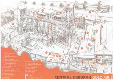
Document - CENTRAL DEBORAH GOLD MINE: PLAN OF SURFACE FEATURES OF MINE
Two copies of a plan of the Central Deborah Gold Mine. Features on the surface of the mine are drawn, labelled and described. Plan printed in orange and grey.bendigo, mining, central deborah gold mine -
Lakes Entrance Regional Historical Society (operating as Lakes Entrance History Centre & Museum)
Book, Town and Country Planning Board Melbourne, Gippsland Lakes Strategy, 1978
A strategy plan to guide future development of the Gippsland Lakes in a rational manner, to benefit all residents and visitors to the area. Contains plans and mapsgovernment, community facilities, recreation -
Whitehorse Historical Society Inc.
Article, Council services awards, 1996
Whitehorse Council has received a commendation award for planning excellence from the Royal Australian Planning Institute for the review of the community grants program.Whitehorse Council has received a commendation award for planning excellence from the Royal Australian Planning Institute for the review of the community grants program.Whitehorse Council has received a commendation award for planning excellence from the Royal Australian Planning Institute for the review of the community grants program.city of whitehorse, awards, royal australian planning institute -
Whitehorse Historical Society Inc.
Map, Anjaya Court, Blackburn, ca1970
[Plan of] Anjaya Court, Blackburn, Lots 6 - 20and of Leons Court, Lots 21-24. One copy with proposed sewerage plan.anjaya court, blackburn, land subdivision, sewerage and sanitation -
 Bendigo Historical Society Inc.
Document - BERT GRAHAM COLLECTION: BENDIGO EAST SWIMMING CLUB
Plans, Bert Graham Collection, Bendigo East Swimming Club, Plan for the construction of the Kiosk. This item quite large and has not been scanned.bendigo, clubs, bendigo east swimming pool -
University of Melbourne, Burnley Campus Archives
Work on paper (item) - Student Work, Annabel Dungey, Birch Tree Residence Project, 2018
assignment, burnley horticultural college -
University of Melbourne, Burnley Campus Archives
Work on paper (item) - Student Work, Perry Lane, Glenlyon RD Landscape Design, Uncertain, probably 2017-2018
Submitted as an assignment for HORT90035, 'Landscape Construction and Graphics,' a subject at Burnley Horticultural College coordinated by Andrew Laidlaw. It seems a third sheet of paper is missing, though one of the folders does contain a rubric showing the mark received for this project. assignment, landscaping, burnley horticultural college, landscape construction and graphics, hort90035 -
Canterbury History Group
Ephemera - A magical reminder of an enchanting era, 1991
Real estate advertisement for the sale by auction on 9 September 1991 of 138 Canterbury Road Canterbury. Includes floor plans and site plans.canterbury, canterbury road, marlowe street, federation style -
Glen Eira Historical Society
Plan - Nettalie
An A4 photocopy of the 'Plan of the Caulfield Road District' dated 1867. This plan shows the location of the properties owned by A Shaw and Blundell on Balaclava and Orrong Roads where Nettalie is situated. The plan includes all the landowners listed where their property was, the street names and other landmarks of 1867 including railways, hotels and reserves.caulfield, caulfield north, elsternwick, st kilda east, parish of prahran, parish of moorabbin, caulfield road district, melbourne and brighton railway, rosstown railway, elsternwick railway station, caulfield railway station, rosstown railway station, murrumbeena railway station, baptist church, paddy’s swamp reserve, cemetery reserve, leman swamp reserve, caulfield racecourse reserve, brighton cemetery, the vine caulfield hotel, the tam o’shanter hotel, melbourne hunt hotel, royal hotel, hotham street, horne street, nepean highway, north road, orrong road, dandenong road, princes highway, kooyong road, alma road, inkerman road, balaclava road, glen eira road, glen huntly road, hawthorn road, cemetery road, bambra road, redan road, kambrook road, neerim road, booran road, racecourse road, grange road, koornang road, murrumbeena road, crosbie road, kangaroo road, poath road, ford w, lempriere, cople j, riddell j c, manifold j, testar t, billing r h, semple, blundell, shaw a, butchart g, stephen j w, stephen g sir, hart j, duncan g, blackie r, stephen f, mccombie t, woollaston h, higgins j, lloyd j c, daish j, mcleod j, hughes d, wilson a, jamieson g, webb g h, renwick s, pennington h, dunn j, kirkpatrick w, ricketson w, toad a, sayce j, watts t, widgery, store, guess j, anketell j, clack j, sissen w, clayton g, dickson d, bevan j, hart t, anderson j, hart mrs, webb h, masters s, waghorn j, hemming c, hiam c, farquhar w, newing t, payne t, cooper r, snipe s, chambers j, forster w, summers r, harriman b, warrick, o’connell, long j, peck r, cochrane c, murray ross w, evans c, kennedy j, maclean n, forster, lyall w, dean j, newton h, looker w, baker c, johnston, crosbie j, kerr, jones, parr, nelson c, montgomery l, parsons w, james j c, sibon c, smith sydney w, plans, maps, land subdivisions, land use, settlements, roads and streets, hotels, churches, police stations, post offices, land surveys, railway stations, railways, schoolhouses, commerce, clergy residences, official buildings, local government, road districts -
Whitehorse Historical Society Inc.
Article, A Living, working view of our heritage, 1992
Matheson's Orchard, the last working orchard in NunawadingMatheson's Orchard, the last working orchard in Nunawading will soon be open to the public. Council purchased the orchard in 1988. The plan is to run the orchard as it would have operated in the 1930's providing a living and working view of Nunawading's heritage. The eldest child, Marjory, wife of Rev Rhys miller is writing a history of the orchard for Council.Matheson's Orchard, the last working orchard in Nunawading orchards, matheson, charles, city of nunawading -
Glen Eira Historical Society
Plan - Bokhara Road, 28, Caulfield South
A hand drawn plan (75mm x 147mm) of the house at Bokhara Road, 28, Caulfield, undated and unattributed. The plan includes notes about the dimensions and fittings of the house.bokhara road, caulfield south -
 Kew Historical Society Inc
Plan, Studley Park Estate, 1910
Prue Sanderson, in her groundbreaking ‘City of Kew Urban Conservation Study : Volume 2 - Development History’ (1988), summarised the periods of urban development and subdivisions of land in Kew. The periods that she identified included 1845-1880, 1880-1893, 1893-1921, 1921-1933, 1933-1943, and Post-War Development. These periods were selected as they represented periods of rapid growth or decline in urban development. An obvious starting point for Sanderson’s groupings involved population growth and the associated economic cycles. These cycles also highlighted urban expansion onto land that was predominantly rural, although in other cases it represented the decline and breakup of large estates. A number of the plans in the Kew Historical Society’s collection can also be found in other collections, such as those of the State Library of Victoria and the Boroondara Library Service. A number are however unique to the collection.The Kew Historical Society collection includes almost 100 subdivision plans pertaining to suburbs of the City of Melbourne. Most of these are of Kew, Kew East or Studley Park, although a smaller number are plans of Camberwell, Deepdene, Balwyn and Hawthorn. It is believed that the majority of the plans were gifted to the Society by persons connected with the real estate firm - J. R. Mathers and McMillan, 136 Cotham Road, Kew. The Plans in the collection are rarely in pristine form, being working plans on which the agent would write notes and record lots sold and the prices of these. The subdivision plans are historically significant examples of the growth of urban Melbourne from the beginning of the 20th Century up until the 1980s. A number of the plans are double-sided and often include a photograph on the reverse. A number of the latter are by noted photographers such as J.E. Barnes.Coloured lithograph of a subdivision plan of the Studley Park Estate, bordered by Yarra, Willsmere Road and the Outer Circle Railway line. The estate was listed in 1910 and was the subject of a planning dispute between the developer and the Town of Kew in relation to flood levels and the suitability of the land for housing. In many cases the names of streets were subsequently changed. The layout was also affected by the creation of the Eastern Freeway. A newspaper report of the day described the subdivision as a: "GOLDEN OPPORTUNITY. We are pleased to submit for PRIVATE SALE that magnificent ESTATE, situated only 4 1/2 miles from the Melbourne General Post Office, STUDLEY PARK ESTATE. KF/NV. Doubtless the CHEAPEST LAND EVER OFFERED having extensive frontages to the prettiest spot on the River Yarra and the National Park, commanding lovely river and landscape views, and acknowledged to be the finest land available so close to the city. The PRICES ARE EXTREMELY MODERATE; The TERMS ARE SIMPLY MARVELLOUS. NO DEPOSIT. NO DEPOSIT. NO DEPOSIT. Allotments and prices to suit everyone."subdivision plans - kew, studley park estate -
University of Melbourne, Burnley Campus Archives
Document - Register, University of Melbourne (Burnley Campus)-Grassy Woodland Plant List, c.1990
(1) List of plants established in the grassland (by number but no plan) compiled by Chris Findlay and Phil Tulk. (2) Burnley Native Grassland Plant List, numerical order (no plan) and alphabetical order , not the same as (1). Stored with Plans of Water Garden.plants, grassland, chris findlay, phil tulk, native grassland, water garden, plans -
University of Melbourne, Burnley Campus Archives
Plan, Burnley Gardens. City of Richmond. Parish of Jika Jika - County of Bourke, 1927
Plan showing Burnley Gardens - bounded by Swan St to N, Yarra River to E, Richmond Park on S and W side. Photo-lithographed at Dept. of Lands & Survey by W.J. Butson. Plan shows old orchard, fowl sheds, coops and yards, milking shed, silo, nursery, glasshouse, fattening pens, dairy, garden, orchards area in S.W. area.burnley gardens, orchards, sheds, nursery -
University of Melbourne, Burnley Campus Archives
Plan, Henderson Residence, 1991
Landscape plans for a residence in Hawthorn, Victoria by Patrick and Wallace Pty. Ltd. For Mr and Mrs N. Henderson. Drawn by RK February 1991. (1) Tracing paper and paper copies, Drawing No.9080/LD1, 'Hardworks Plan.' (2) Tracing paper copy, Drawing No. 9080/LD2 Hardworks Details.' (3) Tracing paper copy, Drawing No. 9080/3 'Planting Plaresidence, mr henderson -
 Ringwood and District Historical Society
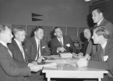
Photograph, Jaycee's Community Service Commission discussing plans for Jaycee Week
Written on back of photograph, "Jaycee's Community Service Commission discussing plans for Jaycee Week". [no date] -
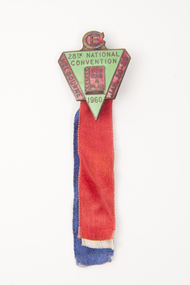 Uniting Church Archives - Synod of Victoria
Badge
Green and red triangular shaped badge on red, blue and white ribbons."CE" "20th National Convention 1960" "God has a plan" "Melbourne Jan - 20 - 28" -
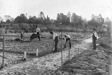 University of Melbourne, Burnley Campus Archives
Photograph - Black and white print, Noelle Kendall (Vaughan), Reconstructing the Vegetable Garden May 1918, 1918
2 copies black and white photograph. Copy of photograph in Noelle Kendall's (née Vaughan) photograph album (B09.0003). 3 men and a child working in the vegetable section of the Orchard. Wooden wheelbarrow. Male teacher supervising.On reverse, "Re-planning vegetable garden May 1918. Man supervising could be George Russ."noelle kendall (née vaughan), vegetable garden, george russ, students working outside, orchard, wheelbarrow -
Dandenong/Cranbourne RSL Sub Branch
Memorabilia - Framed Military Memorabilia
Wooden frame containing Military Memorabilia.Pamphlet "Tobruk to Borneo". Newspaper cutting "Old soldier Tom VC plans a quiet toast". -
Glenelg Shire Council Cultural Collection
Plan - Plan - subdivision at Cape Bridgewater, 02/04/1992
Black and white photocopy of an old plan of a subdivision at Cape Bridgewater. In two halves, not joined together. Black texta numbers on some of the lots 1 - 28town planning, residential, cape bridgewater