Showing 31212 items
matching building a
-
 El Dorado Museum Association Inc.
Photograph (item) - Digital Image
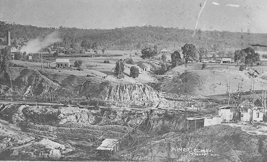
Cocks Pioneer Electric Gold & Tin Mine Company was formed in 1899. The company's first power station, located at the eastern end of the valley began operating with its 340 Kilowatt steam-powered generator. By 1909, from 2,500,000 cubic yards worked, reported recovery was 17,284 ounces of gold and 224 tons of tin ore. By 1909, Cocks Pioneer’s power plant had become inadequate and uneconomical. The barge was floated downstream about a mile, but lost time caused the operations to cease. Following testing, a new mine was established by diverting Reid's Creek at a cost of £25 000. Settling dams were built, one of which held 1,935,900 cubic feet. Sold earth banks, built against a wall of stringy bark saplings constructed and laced with vertical props, were built. In 1914, the company was reformed as Cock’s Pioneer Gold and Tin Mines NL, another power station was constructed at the western end of the township, near the junction of Clear and Reid's Creeks. From 6,800,000 cubic yards of material processed, the returns were 64,397 ounces of gold and 855 ton of tin. Cocks Pioneer mine then moved the barge downs stream and continued sluicing. In 1929 Cocks Pioneer Electric Gold and Tin Mining Company ceased operations due to a drop in values. Cock’s Pioneer Gold and Tin Mines NL carried on large-scale hydraulic sluicing operations until 1941. Handwritten across photograph: "PIONEER" - ELDORADO / F FOXCROFT PHOTO.mining, mines, gold, tin, gold mining, tin mining, sluicing, cocks pioneer, el dorado, eldorado -
 Lakes Entrance Regional Historical Society (operating as Lakes Entrance History Centre & Museum)
Book, Black, Bill and Rash, Esme, History of Willis, 2007
Report, using guidelines as outlined in the Burra Charter, on the building on the northern end of the Port Albert wharf, currently used by Port Albert Seafoods. The building is due for demolition in April, 2007.township, waterways -
 Whitehorse Historical Society Inc.
Photograph, East Burwood Football Pavilion, 2007
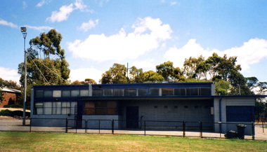
Coloured Photo of the East Burwood football Pavilion erected in 1980/81. Social committee room on left of building erected c1983. Building now used for other Council purposes.east burwood football club pavilion -
 Lakes Entrance Regional Historical Society (operating as Lakes Entrance History Centre & Museum)
Photograph, 1950
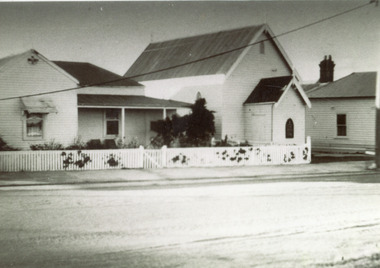
House beside church was purchased as the Parsonage when as ordained minister was appointed.Black and white photograph of the Methodist Church and house on Esplanade. Building is traditional style , small timber building painted white with dark painted gable roof. Lakes Entrance Victoriapeople, religion -
 Lakes Entrance Regional Historical Society (operating as Lakes Entrance History Centre & Museum)
Photograph, Lakes Post Newspaper, 2001c
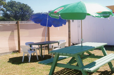
Owners had to provide service of alcohol in order to retain their licence. Locals referred to site as 'The Porta Pub'Colour photograph of tables and umbrellas for beer garden, next to portable building on site of what was the Club Hotel, after the fire had destroyed the original building. Lakes Entrance Victoriarecreation, disasters -
Lakes Entrance Regional Historical Society (operating as Lakes Entrance History Centre & Museum)
Photograph, M Holding, 28/09/2007 12:00:00 AM
Second colour photograph taken at a different angleColour photograph of Heyfield Motel and Apartments taken during additions to building showing scaffolding around building and framing in place for upper level, 115 Esplanade Lakes Entrance Victoriaaccommodation -
 Mt Dandenong & District Historical Society Inc.
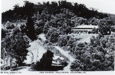
Photograph, View Showing 'Hollywood' Kalorama, Vic
Copy of Rose Series postcard #251 showing 'Mountjoy' named as 'Hollywood'. Mount Dandenong and Ridge Roads are visible at the FiveWays intersection along with the TeaRoom/Post Office. c1940Black and white photograph of a bushed setting with a building centre front and another, larger building up hill on RHS. Two unmade roads are visible with fences and telephone/power poles.The ROSE SERIES P. 251 VIEW SHOWING "HOLLYWOOD". KALORAMA, VIC.rose series, fiveways, guest house, mt dandenong road, ridge road, post office, hollywood, tea rooms, mountjoy -
 Bendigo Historical Society Inc.
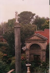
Photograph - FORTUNA COLLECTION: FORTUNA VILLA ROMAN BUILDING
Colour photo of small, ornate Roman style building in Fortuna gardens, tall Doric style column separate to building on LH side, adorned with statue on top. 1990 image.bendigo, hotel, fortuna villa -
 Bendigo Historical Society Inc.
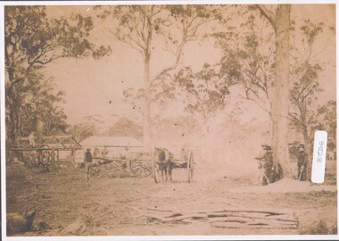
Photograph - On the goldfields
BHS CollectionWorking on the Goldfields. Three men with shovels on the RHS, two horses and drays centrally positioned; and men building a building frame, which appears to have animal carcasses hang up. goldfields, surface mining activity -
 Sunbury Family History and Heritage Society Inc.
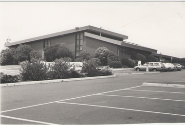
Photograph, C1980
The Sunbury Leisure Centre in Elizabeth Drive was built as a community learning and activity centre for many local groups in Sunbury. It was completed in 1980 and officially opened on 25th February 1981 by the Premier of Victoria Hon. R.J.Hamer The Sunbury Leisure Centre is an important meeting place for many community groups in Sunbury.A black and white photograph of a large brick building, surrounded by a garden bed with low growing shrubs. An extensive car parking area is in front of it with four cars parked outside the building. sunbury leisure centre, elizabeth drive -
 University of Melbourne, Burnley Campus Archives
Photograph - Black and white prints and negatives, Miscellaneous Burnley Buildings
Negatives and some prints. Some scanned. (1) Rear of Student Amenities Building. (2, 3) Administration Building (4) Electric meter box (5, 6) Inside the Librarylibrary, student amenities building, electric meter box, administration building -
University of Melbourne, Burnley Campus Archives
Plan (Item) - Plans & elevations, [Bookshop] Plans & elevations Burnley Horticultural College
dairy, student bookshop, burnley horticultural college -
Canterbury History Group
Photograph - Canterbury Road view of the Canterbury Mansions at No. 208 Canterbury Road, Jan Pigot, 1994
Coloured photograph of the Canterbury Road view of the 3 storey Victorian Building called Canterbury Mansions. Also depicts the corner roof tower and the sold sign after the auction of the building.canterbury, canterbury road, shops, victorian architecture, signs -
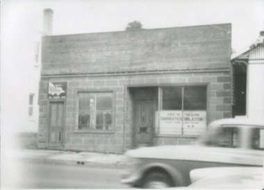 Kilmore Historical Society
Photograph, 33-35 Sydney Street, 1950's?
Shop in space where Drummonds Garage, now used by Wilson Partners Real Estate.18cm x 13cm black and white photograph of a single story building with dark brick facade. Two occupants are using the building, "Heatane"and Eric W. Tulloh Barrister Solicitor.Written on the back: Shop in space where Drummonds garage. now used by Wilson Partners.shopfront, storefront, retail store -
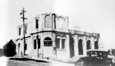 Surrey Hills Historical Society Collection
Photograph, Demolition of Tower House Day and Boarding School, Surrey Hills in 1932 (1)
This building dated back to the 1880s and had previously operated as Delany's Hotel and then the Royal Hotel. It was built near the site of the original Delany's Hotel, built in 1856. The Royal Hotel closed in 1921 after the area voted to be a 'dry area' in the local option poll. Tower House Day and Boarding School operated from 1921 until 1932. Norman Carter took many photos of Surrey Hills and Mont Albert from the 1920s; many were associated with events and activities of the Church of England.Black and white photo of a partially demolished building. The roof and part of the second storey are missing. What remains indicates that it has been a large building in the Victorian style. Along one side at ground level there are 4 arches, perhaps entry to a covered veranda, above which is a colonnade, and perhaps an open veranda on the upper level. There is a mixture of treatments to the surrounds of the windows. On the corner, within an arch which may have once been a doorway, is a sign reading: "TOWER HOUSE / DAY / & / BOARDING SCHOOL". There is a car with a retractable hood in the lower RH Corner of the photo.Rear top centre in blue biro "1932" (crossed out); top RH corner "498" in red biro; centre "Demolition of / Tower House Day & Boarding / cr Canterbury & Broughton Rds / previously Tower House Hotel / originally Royal Hotel / See partner photo."; bottom RH cnr "demol (in red biro) / 20-8-32". All in Jocelyn Hall's handwriting.tower house day and boarding school, schools, education, royal hotel, hotels, construction and demolition, dry area, licensing polls, temperance movement, delany's hotel, norman carter -
Warrnambool and District Historical Society Inc.
Photograph - Wangoom Methodist Church members, 1888
This is a photograph of those attending the Wangoom Methodist church picnic and christening in 1888. The Wangoom Methodist church was established in 1859 on the Wangoom Road. It was a weather board building seating 100 people. The Gothic windows and the pulpit came from the first Warrnambool Wesleyan chapel (1850) The church closed in 1963. The Christening was of a Dixon child and the Dixon family were early members of the Wangoom church congregation. This photograph is of considerable significance as it documents some of the congregation of the Wangoom Methodist church in 1888 and the clothing worn at the time. This is a faded photograph mounted on a piece of cardboard. It depicts gentlemen, ladies and children standing and sitting in front of a building. The ladies and children are wearing hats and the gentlemen are dressed in suits.Two ladies are holding babies. A separate item is a piece of brown paper with blue ink hand writing. WANGOOM OCT. 18 1888 Wangoom Methodist Picnic and Christening Dixon Baby.wangoom methodist church, warrnambool methodism, dixon, wangom -
 Kew Historical Society Inc
Plan, Melbourne & Metropolitan Board of Works : Borough of Kew : Detail Plan No.1568, 1905
The Melbourne and Metropolitan Board of Works (MMBW) plans were produced from the 1890s to the 1950s. They were crucial to the design and development of Melbourne's sewerage and drainage system. The plans, at a scale of 40 feet to 1 inch (1:480), provide a detailed historical record of Melbourne streetscapes and environmental features. Each plan covers one or two street blocks (roughly six streets), showing details of buildings, including garden layouts and ownership boundaries, and features such as laneways, drains, bridges, parks, municipal boundaries and other prominent landmarks as they existed at the time each plan was produced. (Source: State Library of Victoria)This plan forms part of a large group of MMBW plans and maps that was donated to the Society by the Mr Poulter, City Engineer of the City of Kew in 1989. Within this collection, thirty-five hand-coloured plans, backed with linen, are of statewide significance as they include annotations that provide details of construction materials used in buildings in the first decade of the 20th century as well as additional information about land ownership and usage. The copies in the Public Record Office Victoria and the State Library of Victoria are monochrome versions which do not denote building materials so that the maps in this collection are invaluable and unique tools for researchers and heritage consultants. A number of the plans are not held in the collection of the State Library of Victoria so they have the additional attribute of rarity.Original survey plan, issued by the MMBW to a contractor with responsibility for constructing sewers in the area identified on the plan within the Borough of Kew. The plan was at some stage hand-coloured, possibly by the contractor, but more likely by officers working in the Engineering Department of the Borough and later Town, then City of Kew. The hand-coloured sections of buildings on the plan were used to denote masonry or brick constructions (pink), weatherboard constructions (yellow), and public buildings (grey). Plan No.1568 covers the area bounded by Cotham Road, John Street, Sackville Street, and Edward Street. Alfred Street and Rowland Street are in shown in the middle of the plan. The two most notable buildings shown are ‘St Helliers’, the home of the Dumaresq family, and St Hilary’s Church and school. While the colours used to indicate St Hilary’s are grey as in other civic/public buildings, the first St Hilary’s Anglican Church was at this stage constructed in weatherboard. At the left of the plan, facing Sackville Street is a house named ‘Glencara’. The 1988 ‘Kew Conservation Study’ recorded that “The first documentary evidence of this house comes from Rate Books which record that in 1893 a Mrs Treadway was the owner of this building with an N.A.V. of £81? At that date the occupier of the house was Charles B. Kelly, a clerk, while by 1910 Kelly had become the owner of the property described in that year ‘as a six-roomed stone, brick and wood house with stables and outbuildings’”. Contrary to this description, the 1905 plan indicates that the house was entirely constructed of masonry.melbourne and metropolitan board of works, detail plans, mmbw 1568 -
 Kew Historical Society Inc
Plan, Melbourne & Metropolitan Board of Works : Borough of Kew : Detail Plan No.1573, 1905
The Melbourne and Metropolitan Board of Works (MMBW) plans were produced from the 1890s to the 1950s. They were crucial to the design and development of Melbourne's sewerage and drainage system. The plans, at a scale of 40 feet to 1 inch (1:480), provide a detailed historical record of Melbourne streetscapes and environmental features. Each plan covers one or two street blocks (roughly six streets), showing details of buildings, including garden layouts and ownership boundaries, and features such as laneways, drains, bridges, parks, municipal boundaries and other prominent landmarks as they existed at the time each plan was produced. (Source: State Library of Victoria)This plan forms part of a large group of MMBW plans and maps that was donated to the Society by the Mr Poulter, City Engineer of the City of Kew in 1989. Within this collection, thirty-five hand-coloured plans, backed with linen, are of statewide significance as they include annotations that provide details of construction materials used in buildings in the first decade of the 20th century as well as additional information about land ownership and usage. The copies in the Public Record Office Victoria and the State Library of Victoria are monochrome versions which do not denote building materials so that the maps in this collection are invaluable and unique tools for researchers and heritage consultants. A number of the plans are not held in the collection of the State Library of Victoria so they have the additional attribute of rarity.Original survey plan, issued by the MMBW to a contractor with responsibility for constructing sewers in the area identified on the plan within the Borough of Kew. The plan was at some stage hand-coloured, possibly by the contractor, but more likely by officers working in the Engineering Department of the Borough and later Town, then City of Kew. The hand-coloured sections of buildings on the plan were used to denote masonry or brick constructions (pink), weatherboard constructions (yellow), and public buildings (grey). This plan has detailed annotations written in red or blue ink, showing prices, which may be the annual valuations of the properties, and some owners’ names, a most unusual feature on contractor's maps. Some areas, such as the buildings of Methodist Ladies’ College (MLC), include the school’s tennis court and swimming pool, but are not coloured to show building materials – did the draftsman just run out of time, or ink, or enthusiasm, before his plan had to be submitted? MLC had been founded in 1882 as a ‘modern school of the first order’ with buildings that formed ‘a collegiate institution for girls unsurpassed in the colonies’. The goal of its founders was to provide a high-class Christian education for girls, comparable with that provided elsewhere for boys. Some shops are shown along Edgevale Road, though they are not designated as commercial premises. Larger houses are depicted, including ‘Fairlawn’ in Barkers Road, and ‘Clevedon’ and ‘Rosehill’ (now demolished) in Fitzwilliam Street.melbourne and metropolitan board of works, detail plans, mmbw 1573, maps - borough of kew, cartography -
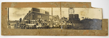 National Wool Museum
Photograph - Staff Group Portrait, Collins Bros Mill Pty Ltd, 1930s-1940s
The Collins No. 2 Woollen Mill building dates from around the 1930s, however related buildings at that site were first constructed from around 1918, that was the Marnock Vale Wool Scouring Works. The Union Woollen Mill founded in the 1870s by William Henry Collins, a major Geelong industrial enterprise, was among the local firms which flourished during the First World War period. From 1914-1918 Collins Bros. concentrated on equipment for the A. I. F. However, afterwards Collins Bros. Pty. Ltd. specialised in the manufacture of flannels and blankets. From 1920 to 1938 the output was increased by fifty percent, and the number of employees rose to 200. The Collins Bros. No. 2 Mill was established in Bridge Street, Newtown. The proprietary brand 'Physician' became well and favourably known throughout Australia source: Heritage Victoria The Collins Bros Mills No. 1 and No. 2 hired over 250 people, and produced between 40,000 and 60,000 blankets for both the Australian market and for overseas export. Collins Bros closed both mills in 1974.Landscape photograph mounted on board showing a group portrait of staff seated and standing together in front of the Collins No. 2 Woollen Mill, Bridge Street, Newtown. Buildings, a chimney, towers, tanks, farmland, a car, powerlines and dirt roads are shown in the background. -
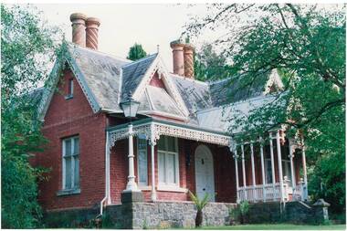 Buninyong & District Historical Society
Photograph - Original Colour Photograph, Clifton Villa, Buninyong, built c1860, 1991
"Clifton Villa", cnr Eyre and Winter Sts, Buninyong, was built c.1860 for Mr Newman. The red brick building has bluestone foundations, cast iron lacework verandah trim, high ornate gables, slate roof and unusual round brick chimneys with spiral brick decorations.Historically significant brick home built c.1860 for Mr Newman. Ornate decorations make this an unusual example of homes of the era.Colour photo of "Clifton Villa", cnr Eyre and Winter Sts, Buninyong. Built c.1860 for Mr Newman. The red brick building has bluestone foundations, cast iron lacework verandah trim, high ornate gables, slate roof and unusual round brick chimneys with spiral brick decorations."Clifton Villa 1862" Taken 1991clifton villa, eyre st, winter st, buninyong, newman -
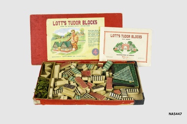 Whitehorse Historical Society Inc.
Leisure object - Lotts Tudor Blocks 4, 1920s
The Tudor Blocks sets included new blocks that were interchangeable with the other Lott's bricks, but had with one profiled surface with a single colour of paint on the raised surface, which gave the appearance of the panels of a wood-framed Tudor building, or of leaded windowsLarge cardboard box containing many blocks & four "trees". A book of illustrations of models. The Tudor Blocks sets included new blocks that were interchangeable with the other Lott's bricks, but had with one profiled surface with a single colour of paint on the raised surface, which gave the appearance of the panels of a wood-framed Tudor building, or of leaded windows.Lott's Tudor Blocks new series illustrations of models. Boxes 1-6, price1/6, Lotts Bricks Ltd, Watford England. Note: Price 1/6 means one pound 6 shillingstoys, lotts tudor blocks, building blocks -
Glen Eira Historical Society
Caulfield Properties
Photographs of various houses, mansions, churches, buildings, monuments in Caulfieldcaulfield, houses, mansions -
Federation University Historical Collection
Photograph, BCAE Computer Laboratory, c1976
A man sits at a computer in F Building, Mt Helen campus.computers, computer laboratory, f building -
 Federation University Historical Collection
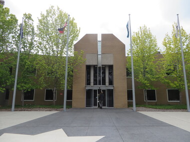
Photograph - Photograph - Colour, Federation University Mount Helen Campus Flag Pole, 25/11/2016
Colour photograph of a brown brick building on the Mount Helen Campus. federation university, mount helen campus, flagpoles, buildings -
 Bendigo Military Museum
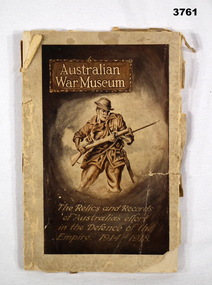
Book - BOOK, MUSEUM, Osboldstone & Co, Australian War Museum, c.1922
Guide book for Australian War Museum Exhibition Building, Melbourne.book, guide, museum -
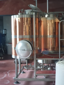 Federation University Historical Collection
Photograph, Clare Gervasoni, Federation University Brewery, 2021, 12/12/2021
Colour photograph of the brewery in Y Building, Mount Helen Campusbrewery, brewing, y building, mount helen campus -
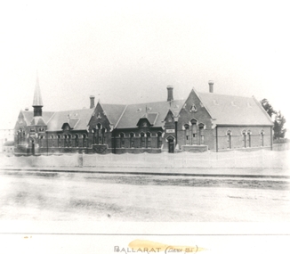 Federation University Historical Collection
Photograph - black and white, Dana Street State School, Ballarat
Photograph of a brick building known as Dana Street Primary School.education, school, dana street state school -
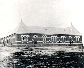 Federation University Historical Collection
Photograph - black and white, Golden Point State School, Ballarat
Photograph of a brick building known as Golden Point Primary School.education, school, golden point primary school -
Federation University Historical Collection
Book, The Network UNE Experience
The Network UNE Experience: Reflections on the Amalgamated University of New England 1989 - 1993Blue writing on white covered book with picture of building in the backgroundnon-fictionThe Network UNE Experience: Reflections on the Amalgamated University of New England 1989 - 1993 the network une experience, armidale, coffs harbour, northern rivers, orange, grant harman, rob robertson-cuninghame, susan bambrick, john chudleigh, peter drake, beryl evans, terry field, trevor knight, john lovett, don mcnicol, v. lynn meek, robert napier, lionel e. phelps, robert h.t. smith -
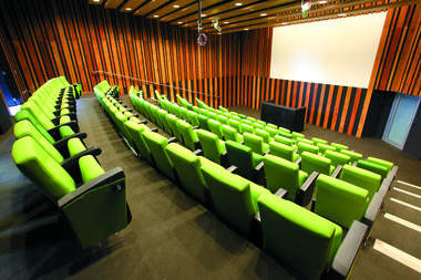 Federation University Historical Collection
Photograph - Aerial Photograph, Federation University Lecture Theatre in Y Building, Mount Helen Campus, 09/07/2013
Colour photograph of Federation University Y Building LEcture Theatrebuildings, mount helen campus, lecture theatre, y building, mount helen