Showing 2508 items
matching goldfield map
-
 Bendigo Historical Society Inc.
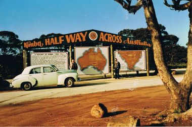
Photograph - PETER ELLIS COLLECTION: PETER ELLIS AND JOHN MEREDITH
Colour photo of Peter Ellis and John Meredith standing in front of the sign at Kimba Half Way Across Australia. There are three signs, one has the History of Kimba, one is a map of Australia and the other is a map with Spencer Gulf printed on it. A green Holden car is parked in front of the History sign.photo, group, male, peter ellis collection, peter ellis, john meredith -
 Bendigo Historical Society Inc.
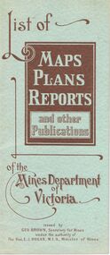
Document - LIST OF MAPS, PLANS, REPORTS PUBLISHED BY MINES DEPARTMENT VICTORIA 1938
... Inc. History House 11 Mackenzie Street Bendigo goldfields ...Blue booklet, on front ' List of Maps, Plans, Reports and other publications of the Mines Department of Victoria. Issued by Geo Brown Secretary for Mines under the authority of The Hon. E.J. Hogan, MLA, Minister of Mines. Booklet contains list of publications of geological reports, maps etc for Ararat, Ballarat, Beechworth, Bendigo, Castlemaine, Gippsland, Maryborough.Geo Brown, Secretary for Mines under the authority of The Hon.E.J. Hogan, M.L.A. Minister of Mines.organisation, government, geological maps list -
 Bendigo Historical Society Inc.
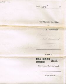
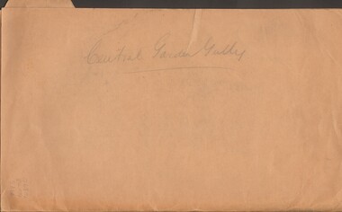
Document - MCCOLL, RANKIN AND STANISTREET COLLECTION: MINING LEASE NO 10173 GARDEN GULLY SHAFT, 9th March, 1934
Mining lease 5 page document for lease application 10173, dated 9th March 1934, within area bounded by Don, Barnard Streets up to Mt. Korong Road, area 10 acres. Document signed by John Jepson Stanistreet in the presence of W.A. Kell, Warden's Clerk, Bendigo. Hand coloured plan of lease appended to document, yellow section refers to lease. Marked on map Central Garden Gully shaft. On front of lease ' entered in the Register Book Vol 303 Fol 33698' On back ' His Majesty the King to J.P. Stanistreet (Cent G Gully not renewed written in pencil) Form C Gold Mining Lease Crown and Private Land'gold, mining, garden gully shaft -
 Bendigo Historical Society Inc.
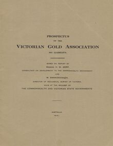
Document - MCCOLL, RANKIN AND STANISTREET COLLECTION: VICTORIAN GOLD ASSOCIATION, 1931
Prospectus of the Victorian Gold Association N.L. Based on a report by Messrs H. W. Gepp Consultant on Development to the Commonwealth Government and W. Baragwanath, Director of the Geological Survey of Victoria. Dated 1931 This company was formed to investigate the Deborah Mine, The Central Nell Gwynne Mine and the Monument Hill Mine. 12 pages including maps and Transverse Sections of the MinesThe Commonwealth and Victorian State Governments. E. Whitehead & Co., Pty., Ltd Printers 21 Equitale Place, Melbourne, C1.gold, mining, prospectus, bendigo, gold mines, victorian gold associatian, deborah mine, central nell gwynne mine, monument hill mine. -
 Bendigo Historical Society Inc.
Document - MCCOLL, RANKIN AND STANISTREET COLLECTION: CENTRAL GARDEN GULLY
Manilla Folder containing correspondence and applications for a mining lease on the Garden Gully Line known as Mumford's Claim, also contains maps of lease numbers 9993, 10173, and 10390 (all on the Garden Gully Line).McColl Rankin & Stanistreet, Charing Cross Bendigogold mining, miners' safety cage, central garden gully, mining, gold mines, bendigo, garden gully, mumfords claim -
 Bendigo Historical Society Inc.
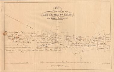
Document - MARKS COLLECTION: ABE LINCOLN CO LEASE
Two copies of plan for Abe Lincoln Co. Lease, New Chum, Sandhurst. One original, one copy. On top of plan 'Plan Showing Position of the Abe Lincoln Co. Lease, New Chum, Sandhurst' under name 'by H.B. Nicholas, Mining Surveyor' Sheepshead Reef, Easter reef, Alfred Reef, Allingham Reef,Adventure Reef, Belle Vue Reef, New Chum Reef, Black Lead, Victoria Reef lines shown on map with mine leases marked. On bottom of map 'Monument Hill Reef' line marked.bendigo, mining, abe lincoln lease -
 Bendigo Historical Society Inc.
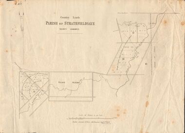
Document - MARKS COLLECTION: MAP OF PARISH OF STRATHFIELDSAYE 1858, 8th September, 1858
... Inc. History House 11 Mackenzie Street Bendigo goldfields MAP ...Buff coloured document. On top 'Country Lands, Parish of Strathfieldsaye, County Unnamed'. On bottom 'Scale 40 chains to an inch. Public Lands Office, Melbourne Sept 8th. 1858. William Collis, Lith ( lithographer )'. Map shows Village Reserve on Emu Creek, road from Sandhurst, Sheepwash Creek and Splitters Creek. Wellington Hotel marked on map near intersection of Sheepwash Creek, Axe Creek and Emu Creek. Axe Creek Pound near Splitters Creek.map, bendigo, parish of strathfieldsaye 1858 -
 Bendigo Historical Society Inc.
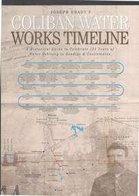
Document - JOSEPH BRADY COLLECTION: COLIBAN SYSTEM OF WATER WORKS PAMPHLET
Three copies of Joseph Brady's Coliban System of Water Works - A Historical Guide to Celebrate 125 Years of Water Delivery to Bendigo & Castlemaine by Coliban Water. Mentioned in the brochure is Gold & Water, The Original Coliban System of Water Works, The Coliban System Today, The Coliban Engineer - Joseph Martin Brady (1828 - 1908), Coliban System of Water Works Key Facts & Figures, The Aqua Project, Historical Guide, Coliban System of Water Works Map, photo of Joseph Brady, Photo of gold diggers and channel works.Coliban Watercivil engineering, water supply, coliban, joseph brady's coliban system of water works, coliban water, the original coliban system of water works, the coliban system today, joseph martin brady 1828 - 1908, gavan prendergast, coliban system of water works key facts & figures, the aqua project, historical guide to 125 years of water delivery to bendigo & castlemaine, map of system -
 Bendigo Historical Society Inc.
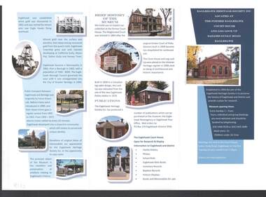
Document - EAGLEHAWK HERITAGE SOCIETY INC BROCHURE
Coloured brochure which contains a brief history of Eaglehawk, opening times for the Museum, a map with points of interest, application for Membership form, a brief history of the Museum, where Publications can be obtained and Research and Displays.eaglehawk heritage society inc brochure, former eaglehawk court house, log lock up, eaglehawk borough council, city of greter bendigo, court of petty sessions, eaglehawk newsagency, eaglehawk post office -
 Bendigo Historical Society Inc.
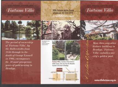
Document - FORTUNA COLLECTION: FORTUNA VILLA
Coloured tri-fold brochure titled Fortuna Villa. There are several coloured photos of the Villa and garden, a short history, information on the Villa Fortuna Action Group and their ideas for its future use. There is also a printed membership form. A small location map is included.bendigo, clubs, fortuna villa, christopher ballerstedt, theodore ballerstedt, 180 mine, george lansell, edith lansell, william beebe, vahland, getzschmann, emil maumann, commonwealth department of defence, the fortuna villa action group, city of greater bendigo, julian prowd, geoff hocking, bart-n-print -
 Bendigo Historical Society Inc.
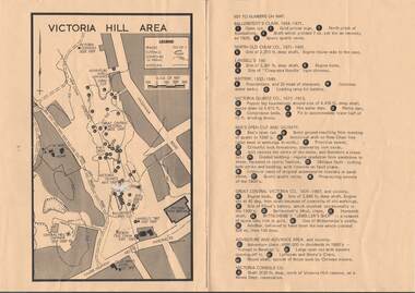
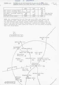
Map - VICTORIA HILL AREA
... Inc. History House 11 Mackenzie Street Bendigo goldfields MAP ...Map of Victoria Hill Area printed on yellow paper. Details of tracks, cuttings, contours (in Metres) and Anticline. Location of mines, open cuts and buildings are shown. Numbers on map are: Ballerstedt's Claim 1 - 5; North Old Chum Co. 6; Lansell's 180, 7,8,11; Battery 9.10.12; Victoria Quartz Co. 13 - 17; Rae's Open Cut and Vicinity 18 - 28, Great Central Victoria Co 29 - 36, Adventure and Advance Area and vicinity 37 - 40 and Victoria Consols Co 41.map, bendigo, victoria hill, victoria hill area, victoria consols, new chum anticline, great central victoria, rae's open cut, w rae's home, victoria quartz, ballerstedt's open cut, lansell's 180, north old chum, central nell gwynne, john brown factory, gold mines hotel, cleopatra needle type chimney, floyd's battery, ballerstedt's 24yd claim, humboldt shaft, wittscheibe's jeweller's shop, luffsman and sterry's claim, victoria hill reserve, mines dept reervation -
 Bendigo Historical Society Inc.
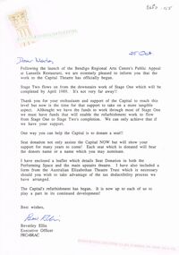
Document - MERLE HALL COLLECTION: CORRESPONDENCE FROM BENDIGO REGIONAL ARTS CENTRE
Correspondence from Bendigo Regional Arts Centre to Merle Hall, Sec Arts Bendigo - 25th Oct (1988) re work to Capital Theatre and Seat Donation; 6 December 1988 re donation from AB of $3000 to Capital Theatre project; November 12 1993 re donation from AB as contribution towards cost of purchasing a map cabinet - handwritten note on letter re the amount of that cheque ?? And comment that the donation never shown in the plaque on the cabinet; 20 June 1997: Reconciliation of the Soul Food recital of Gudrun Beilharz and Peter Bartels (loss). -
 Bendigo Historical Society Inc.
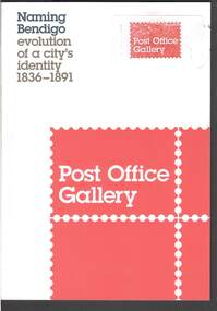
Book - NAMING BENDIGO: EVOLUTION OF A CITY'S IDENTITY 1836 TO1891
Red and white covered booklet titled 'Naming Bendigo evolution of a city's identity 1836 - 1891. It has a sketch map of Bendigo and Golden Square in 1851. It has a number of photos of early paintings, postcards and objects. The Foreword is written by Cr Rod Campbell, Mayor of the City of Greater Bendigo and the Introduction is written by Karen Quinlan, Director. The chapters are titled: Naming Bendigo evolution of a city's identity 1836 - 1891; The Gibson brothers soon renamed the run a popular choice in the 19th century; and to direct that the said place shall be called and known as Sandhurst; endeavoured to ascertain from what source, and at what time, the name of Bendigo arose: "The diggers...at Bendigo are recherché as to names;" and the Exhibition Checklist.event, exhibition, naming bendigo, naming bendigo - evolution of a city's identity 1836-1891, post office gallery, bendigo art galery, studio round, bambra, sandra bruce, karen quinlan, ian hill, national library of australia, city of greater bendigo, elaine harrington, vic lane, reg and judy macdonald, dennis o'hoy, sandhurst trustees, phil wilkins, darren wright, eaglehawk, eppalock, epsom, flora hill, golden square, kangaroo flat, strathfieldsaye, mount alexander run (north, or no 2 - ravenswood run -
 Bendigo Historical Society Inc.
Document - HERITAGE REPORT: FORMER POLICE STATION AND QUARTERS: CALIFORNIA GULLY
Seventeen page Heritage Place Report on the Former California Gully Police Station at 15 Thorpe Street, California Gully. It is the former police station and quarters, former timber stables and timber cottage residence demolished and horse paddock on separate title. Report includes a Statement of Significance, Place History (History of the Area), Policing California Gully Goldfields, History of the Buildings, Chronology of Ownership, Rate Books 1858, - 1867 - 1868, 1895 Borough of Eaglehawk Rates, 1922 Voters Roll, 1952 & 1962 Sands & McDougall Directory Thorpe St California Gully, Comparable Examples, Secondary Sources, Description Conservation Policy Guidelines (Specific), Physical Conditions, Physical Description 1, Map of Early Photo Location, Bendigo Parish Plan circa 1870, Certificate of Title 1950 & 1960. Pge 14 has plans, maps and an aerial photo of 15 Thorpe Street. Page 15 has an aerial photo of 15 Thorpe Street, California Gully with Allotment Size. Page 16 & 17 has photos.heritage, heritage report - former police station and quarters - california gully, city of greater bendigo, wilson & ass, butler, amanda jean, johnson reef shafts no 1 & 2, rose of denmark, princess dagmar, bendigo amalgamated goldfields company, captain frederick standish, royal irish constabulary, e thorpe, campbell, taylor, watson, brown, hosken, mckowne, mcqualter, parker, hicks, eaglehawk municipal council, victorian police force, d bannear, historic mining sites in the sandhurst eaglehawk and raywood mining divisions, department of conservation and natural resources, joshua thorpe, thorpe & co, johnson & co, william thorn, michael thomas, james murdock, edward c brown, francis youlden, gold escort, water police, mounted police, city police (melbourne), geelong police, gold fields police, rural bench constabulary, the people's force, robert haldane, n wild, streets of the borough of eaglehawk, police registration act, william henry mitchell, camp hotel, j o c nieman, j m catarach, g w hosken, margaret hosken nee mckown, majorie alice mcqualter, kellie anne mcqualter, adam joseph doolan, mr hicks, sands & mcdougall, hill george, meeking howard, mcewan frank a, jinks stanley, mccaig mrs eleanor, gordon john l, mcqualter mrs adeline, maher william l, raynor robert, flack john p, whitehead miss a, sang george t, linddsay john p, dyer henry, jackman george a, tibbetts mrs s a, hosken mrs margaret winifred nee mckowne, chaplin frank w, wilson c e, wright george, miller g a, sheyhill basil hugh, marshall r, miles j h, parker w b, barkla w g, nicholls les, cartledge clifford william, cole charles basil, farmers citizens trustees co, bev hanson -
 Bendigo Historical Society Inc.
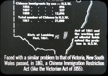
Slide - DIGGERS & MINING. THE CHINESE ON THE GOLD FIELDS, c1850s
Diggers & Mining. The Chinese on the Gold Fields. Slide: Map of New South Wales. Chinese immigration by sea - N.S.W. 1856 - 896, 1857 - 327, 1858 - 12,096. Total number of Chinese in N.S.W. 1861 - 21,000. Riots of Lambing Flat, 1861. Act of 1861 the working out of alluvial fields solved the problem in N.S.W. Faced with a similar problem to that of Victoria, New South Wales passed, in 1861, a Chinese Immigration Restriction Act (like the Victorian Act of 1855). Markings: 10 994:LIF I. Used as a teaching aid.hanimounteducation, tertiary, goldfields -
 Bendigo Historical Society Inc.
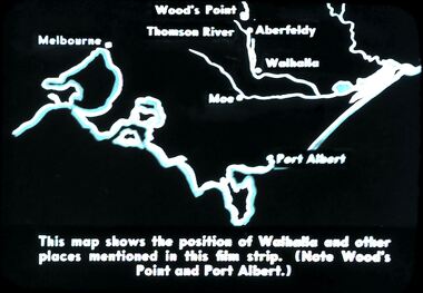
Slide - DIGGERS & MINING. DIGGERS AND MINERS, c1850s
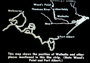
Diggers & Mining. Diggers and miners. Walhalla - Gold Town. This map shows the position of Walhalla and other places mentioned in this film strip. (Note Wood's Point and Port Albert.) Markings: 6 995 WAL. Used as a teaching aid.hanimounteducation, tertiary, goldfields -
 Bendigo Historical Society Inc.
Slide - DIGGERS & MINING. DIGGERS AND MINERS, c1850s
Diggers & Mining. Diggers and miners. Walhalla - Gold Town. This map shows the position of Walhalla and other places mentioned in this film strip. (Note Wood's Point and Port Albert.) Other places on map; Melbourne, Moe, Thomson River, Aberfeldy. Markings: 5 995 WAL. Used as a teaching aid.hanimounteducation, tertiary, goldfields -
 Bendigo Historical Society Inc.
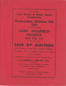
Document - IAN DYETT COLLECTION: AUCTION CATALOGUE - LAKE BELLFIELD PROJECT
Two copies of red covered auction catalogue for sale on account of State Rivers & Water Supply Commission held on 12/10/1966 Lake Bellfield Project, Hall Gap, Vic. Lots include motor vehicles, corr. Iron & timber buildings, machinery, tools, equipment, stores, scrap iron & steel and furniture. J. H. Curnow & son Pty. Ltd. Were the auctioneers. Catalogue has a map from Melbourne & Geelong to site near Hall's Gap and an Auction Layout sketch.business, auctioneers, j h curnow & son pty ltd, ian dyett collection - auction catalogue - lake bellfield project, state rivers & water supply commission, j h curnow & son pty ltd, f c dyett, l c osborne, c hill -
 Bendigo Historical Society Inc.
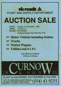
Document - IAN DYETT COLLECTION: AUCTION CATALOGUE - VIC ROADS
Light blue covered auction catalogue with black printing for a sale on 5th December, 1989 at Vic Roads, Glen Waverley. For sale were Motor Vehicles including Sedans, Trucks, Station Wagons, Utilities and 4 x 4's. J. H. Curnow & Son P/L were the auctioneers. Back cover has a map locality and a locality map of the auction area.business, auctioneers, j h curnow & son pty ltd, ian dyett collection - auction catalogue - vic roads plant and supply department, j h curnow & son p/l, bolton bros pty ltd -
 Bendigo Historical Society Inc.
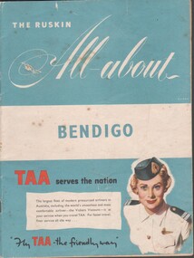
Booklet - Tourist guide, 1956
The Ruskin All-About Bendigo Booklet produced for the 1956 Melbourne Olympics. Includes maps and facts, service organizations and businesses in Bendigo. Includes advertisements for Australian companies. TAA on the cover. Produced by Ruskin Publishing Pty Ltd 37 Swanston St. Melbourne.advertising, services, bendigo businesses, bendigo maps -
 Bendigo Historical Society Inc.
Flyer - Eaglehawk Heritage Society leaflets
Trifold leaflet black print on blue paper, includes map of the Borough and "places of Interest". Includes history of the house "Caradon".historic points of interest within eaglehawk, map of points of historic interest within eaglehawk -
 Bendigo Historical Society Inc.
Book - Geographical dictionary
The Gazetteer presents an extensive a to z list of Victorian towns and villages, lakes, rivers and creeks, islands, bays, hills and mountains, runs and other localities and features. Entries include latitude and longitude, populations, proximity to other towns, local industries, coach and mail runs, hotels, churches and schools.Bailliere's Victorian Gazetteer and road guide containing the most recent and accurate information as to every place in the colony. Brown hardcover book, on the spine: Victorian Gazetteer with map 1865. The first and last pages are advertisements. The book has 442 pages listing every place in the colony. The map is not included. Compiled by Robert P. Whitworth. Published by Bailliere, Regent Street Unreadable name on first page and the name of F. Houston in blue pen on first page geographic dictionary, colony of victoria -
 Bendigo Historical Society Inc.
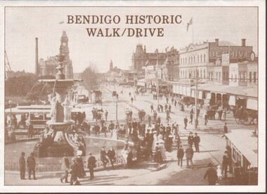
Flyer - Bendigo Historic Walk / Drive
1988 Bendigo Historic Walk / Drive pamphlet. A3 quarter folded to show map of Bendigo and walking tour options to visit local buildings. Dual print in two colours (orange and brown) includes several images.walking tour, driving tour -
 Bendigo Historical Society Inc.
Document - Chinese Distribution in Eaglehawk and Sandhurst in 1861
Chinese Distribution in Eaglehawk and Sandhurst in 1861. Sketch and Map of the Chinese showing their population based on the census.history, bendigo, eaglehawk, chinese, sandhurst -
 Bendigo Historical Society Inc.
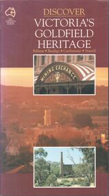
Book - Discover Victoria's Goldfield Heritage
128-page illustrated soft cover book entitled 'Discover Victoria's Goldfield Heritage. Includes Ballarat, Bendigo, Castlemaine and Stawell Written by Douglas Stone and Greg Dunnett First published 1993 by See Australia Guides Pty Ltd Printed and bound by Toppan, Hong Kong Includes route maps, city and town maps, town walks, scenic drives and bike rides.Handwritten in pen PETER RYALL on title page.goldfields, bendigo, ballarat, castlemaine, see australia guides -
 Bendigo Historical Society Inc.
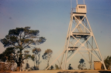
Slide - Peter Ellis Collection, Kaweka Wildflower Reserve, Castlemaine, Lightning Hill Lookout Bendigo, One Tree Hill Lookout Tower Bendigo, Kamarooka Forest Area, c1970-1972
Kaweka Reserve is a a small reserve of approximately 8ha. The land was donated to the Castlemaine City to be a wildflower Reserve. A management committee was formed in 1966. The committee is still managing the park. Vicroads Edition 6: Map 59E2, 628 H4 Location. Turner St, Castlemaine. From the Castlemaine Post Office, drive north (towards Bendigo) and turn right along Turner Street to the park entrance. What to do: walk along some of the tracks through the park follow the nature trail bird watch have a picnic at the picnic tables. RUSH Dam is a basic free camping area sits alongside Rush Dam in the Greater Bendigo National Park, featuring a single picnic table and wood fire barbecue.Peter Ellis Collection: Seventeen slides of Kaweka Wildflower Reserve, Castlemaine, Lightning Hill Lookout Bendigo, One Tree Hill Lookout Tower Bendigo. Also the Rush Dam free camping area at Kamarooka. Also a slide of an unknown group having a meal or day out; perhaps also a working bee. In addition there are two slides of a house - location not specified; and a working bee clearing along a pipeline at Big Hill. Peter was a chemistry lecturer at the Bendigo Institute of technology.history, bendigo, peter ellis collection, whipstick bendigo, bendigo state forests, kaweka wildflower reserve castlemaine, one tree hill lookout bendigo, lightning hill lookout bendigo, kamarooka, rush dam kamarooka, greater bendigo national park -
 Bendigo Historical Society Inc.
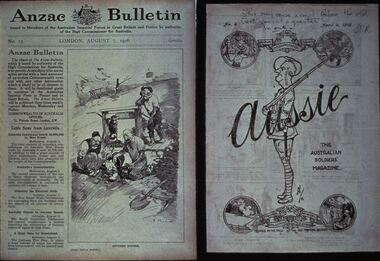
Slide - DIGGERS & MINING: THE DIGGERS, c1918
Diggers & Mining: The Diggers. Slide of ANZAC BULLETIN, London August 7, 1916 (on left of slide). Ride side of slide is the back cover of a Bulletin dated April 4, 1918 with artwork on it, main section has a soldier with the word Aussie across it, the head of the soldier is the map of Australia the wording 'The Australian Soldiers' Magazine' along side the soldier. Markings by hand: This may ease a smile be\fore the bell goes at quarter to one SCR. Dated April 4, 1918. Markings: VISAR COPYRIGHT SET - THE DIGGERS, 13. Used as a teaching aid.Visaireducation, tertiary, war -
 Bendigo Historical Society Inc.
Document - PETER ELLIS COLLECTION: A GUIDE FOR DRIVERS ON THE WHIPSTICK TOUR
A Guide for Drivers on the Whipstick Tour. First page gives assembly area, driving in convoy and negotiating water or boggy patches across the road. Amended written at the end of the page. Directions with mileage and items of interest for the tour on Sunday September 9th (no year). A Whipstick Map 1971 showing State Forest, Crown Lands, Uncleared Mallee - Private (shown in different colours) Water Reserve and Roads. Noted are Flora and Fauna - Plants, Birds & Mammals, and areas of State Forest and Southern State Forest with Mallee Scrub area noted. Also State Forest & Crown Lands Total Area and a map scale. The Bendigo Whipstick mentions area, suggestions of where the name Whipstick came from, shrubs and flowers with their flowering times, descriptions of some of them and some information on the Mallee Fowl. The Eucalyptus Oil Industry paragraph mentions the beginnings of the industry. Mentioned are the different uses of oils (perfumery, industrial and medicinal) and the different species of eucalypt used for each and various products. Also notes on the growing, harvesting and refining of eucalyptus. P Ellis at the end of the page. The next two and a half pages mentions reserves, and at the end acknowledgements. Includes a spare copy of 'The Bendigo Whipstick' by P Ellis.bendigo, history, early bendigo, peter ellis collection, a guide for drivers on the whipstick tour, the whipstick 1971 map, shire of marong, shire of east loddon, shire of huntly, borough of eaglehawk, city of bendigo, shire of strathfieldsaye, the bendigo whipstick, eucalyptus oil industry, eaglehawk town hall, lightning hill lookout, eaglehawk rifle range, new moon mines, blue jacket reservoir, maggetti's wine hall, camp hotel (ex), skylark dam, eucalyptus oil production, eucalyptus factory, whipstick eucalyptus farm, ruedin's eucalyptus factory, dutch bowls, governor philip, sir joseph banks, john white, baron von mueller, joseph bosisto, commonwealth government, perfumery oils, industrial oils, medicinal oils, p ellis, dr frith, csiro wildlife division, harley webster, forests commission, vincent serventy, victorian national parks association, bendigo field naturalists club -
 Bendigo Historical Society Inc.
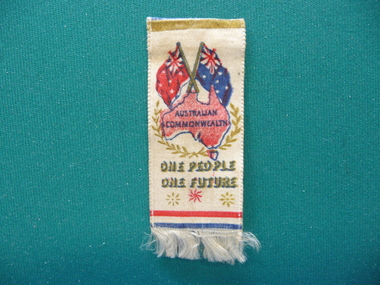
Souvenir - FEDERATION STICK PIN, 1901
Federation Stick pin with ribbon of white satin with map of Australia underneath Australian & Red Ensign flags, worded Australian Commonwealth One People One Future, fringed on bottom.event, official, federation -
 Bendigo Historical Society Inc.
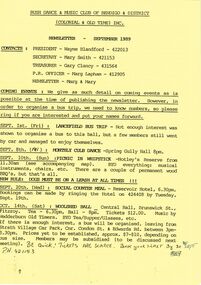
Document - PETER ELLIS COLLECTION: BUSH DANCE AND MUSIC CLUB BENDIGO, September
Three Bush Dance & Music Club of Bendigo & District Newsletters, Sept 1989 (yellow), October 1989 (green) and December 1989 (yellow). Newsletters contain contacts, Coming Events, dance programs and September 1989 edition has a map of how to get to the Notley's Picnic area. Also reports and in the October edition a sketch of how to get to a picnic area in the Wellsford Forest. The December issue has the contacts, Christmas Break-up and next meeting. On the back is the monthly dance dates for 1990.clubs, music, bush dance & music club of bendigo, peter ellis collection, bush dance & music club of bendigo & district, wayne blandford, mary smith, gary clancy, marg lapham, notley's reserve, reservoir hotel, wedderburn old timers, harry mcqueen & friends, lorraine ogilvie, mike jackson, val wilson, barry simpson, peter ellis, victorian folk music club, shirley andrews, john meredith