Showing 123951 items
matching main-road
-
 Kew Historical Society Inc
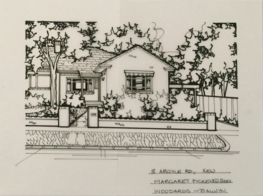
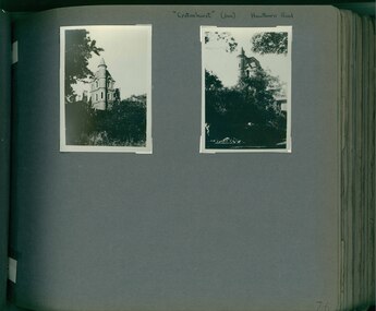
Drawing - Property Illustration, Margaret Picken, 18 Argyle Road, Kew, 2001
After training as a Cartographic Draftsman within the mining industry, I worked as a property illustrator for real estate firms in the eastern suburbs of Melbourne for 23 years from 1983. I initially photographed houses with a Polaroid camera and made a 'thumbnail' sketch while there. The photos were used to scale off a sketch in pencil and then that sketch was overlaid with drafting film and the 'pen and ink' completed. The pens I used were the Rotring ‘Rapidigraph’ drafting pens. The ink was also made by Rotring (German).The film was ‘Rapidraw’, polyester drafting film, double matte. It takes a very fine line and doesn’t bleed. As well as house sketches, there were often floor plans and site plans ordered. Aerial sketches were ordered when the property needed an overall view. (Margaret Picken, 2020)This drawing is one of a series created by Margaret Picken for a range of real estate agents in Melbourne between c.1983 and c.2005. Each work is signed and dated by the artist.Gift of Margaret Picken, 2020Pen and ink drawing on drafting film of 18 Argyle Road, Kew by Margaret Picken.18 ARGYLE RD., KEW / MARARET PICKEN (c) 2001 / WOODARDS ~ BALWYNartist -- margaret picken 1950-, architectural drawings -- houses -- kew (vic.), 18 argyle road -- kew (vic.) -
 Brimbank City Council Art Collection
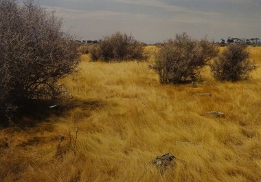
Photograph, Robert Pointon, West of Fairbairn Road, 1989
Local SceneWest of Fairbain Road facing east towards city with grasslands and box thorns. - AR0039 -
 Greensborough Historical Society
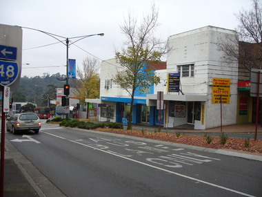
Photograph - Digital image, Noel Withers, Main Street Greensborough 2010, 04/06/2010
View of shops on Main Street Greensborough near Para Road photographed in 2010 by Noel Withers.Digital copy of colour photograph.main street greensborough, para road -
 Phillip Island and District Historical Society Inc.
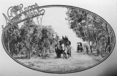
Photography, Wool team on road
Part of collection of Rose & Valentine series of Postcards - copies by John Jansson 1984Black & White Postcard - Copy. Wool team of two wagons on narrow tree lined road.Phillip Island Wool team on road to Cowes - over printed "A Happy New Year"local history, photography, photographs, postcards, views phillip island, wool team, cowes, wagons, phillip island -
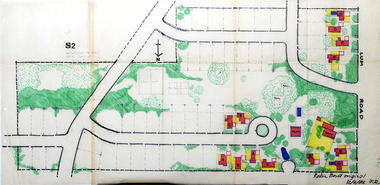 RMIT Design Archives
Work on paper - Architectural drawings, Colour plan of Lum road estate, 1970-1986
This plan of Lum Road Estate includes layout of roads, gardens, building and carparks. From 1970 until August 1971 Robin Boyd and his practice Romberg & Boyd Architects worked on designs for housing on the Lum Road Estate, Wheelers Hill. Berenice Harris, Linley Vellacott and Karl Fender drew many of the sketch plans for the project homes, while Robin Boyd drew the perspectives. This colour plan of the estate was drawn by Robin Boyd, but not signed. Frederick Romberg later annotated the drawing with details of its authorship. Colour plan of Lum road estate. Includes layout of roads, gardens, buildings and flora.Inscribed lower right on recto in black ink, 'Robin Boyd original / 12/6/86 F.R' ; Inscriber upper left on recto, grey pencil, '3400'.architecture, design, rmit design archives, domestic architecture -
 Stawell Historical Society Inc
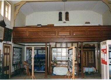
Photograph, Interior of the old courthouse (Main Room)
2 colour Photographs of the Interior of the old courthouse (Main Room)stawell historical society, old court house -
 Stawell Historical Society Inc
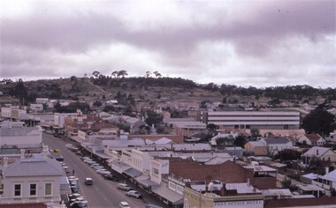
photograph - Slides, Ian McCann, Main Street Looking towards Bg Hill, 1976 - 1984
Colour Photograph of Main Street looking towards Big Hill -
 Stawell Historical Society Inc
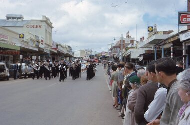
Photograph - Slide, Stawell Band Marching in Main Street
Stawell Band Marching in Main Street with crowd lining the Street -
 Stawell Historical Society Inc
Photograph - Slide, Main Street at Easter with flags
Main Street Look toward the Grampians with flags over the Street. -
 Stawell Historical Society Inc
Photograph, Ian McCann, Main Street - Gold Reef Mall, c 1987
Laying pipes in main street looking towards big hillgold reef mall -
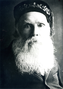 Whitehorse Historical Society Inc.
Photograph, Thomas Main, Father of Mary Husband
Black and white photo of Thomas Main, Father of Mary Husband.main, thomas, husband, mary c, charles edward -
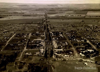 Melton City Libraries
Photograph, Main Street, Melton, 1973
Bird's eye view of Main Street, Melton, looking west.landscapes of significance -
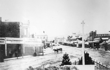 Stawell Historical Society Inc
Photograph, Main Street looking East from Coffee Palace area 1880
Main Street Looking East 1880 from weigh bridge area, taken from Coffee Palace verandah. Two story buildings with veranda's. Horse drawn vehicle center of image. Post office and Town Hall visible in background. Bond Drapery. J & A Price Wine Spirits. Bond Draper sign on right. Two Poppet Heads on Big Hill are the No2 North Waterloo and the Waterloo and Argyle Mines.Black and white photograph looking East along Main Street from Weighbridge area where two streets join. Horse drawn buggy in center of street with buggy. Big Hill in distance with two poppet heads just visible.stawell businesses streetscape -
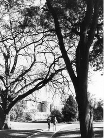 University of Melbourne, Burnley Campus Archives
Photograph - Black and white print, Peter Esdale, The Oak Lawn and Main Building, 1990-1991
5 copies black and white photograph, one an enlargement taken by P. Esdale. View taken from Oak Lawn towards the Administration Building with a back view of 2 people walking along the path. All the same but with different descriptions on their reverses.On reverse of (a), "The Main Building VCAH Burnley 1990. Photo courtesy of P. Esdale," and on reverse of (b), "The oak lawn and Main Building. Peter Esdale 1990." (c) On reverse, "Main Building VCAH Burnley 1991 Eastern Aspect."1990., administration building, oak lawn, students, main building, trees, garden view -
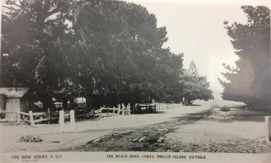 Phillip Island and District Historical Society Inc.
Photograph, The Beach Road, Ccowes
Part of a collection of 'Rose & Valentine' series of Post Cards. Copied by John Jansson 1984View along the Beach Road, Cowes looking towards the Isle of Wight Hotel on left of photograph (hidden by the trees).The Beach Road, Cowes Phillip Island Vic. The Rose Series P.674.local history, photography, photographs, postcards, cowes, phillip island, black & white photograph, the esplanade cowes, isle of wight hotel -
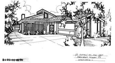 Hawthorn Historical Society
Drawing - Property Illustration, 1/ 6 Clifton Road, Hawthorn East
'After training as a Cartographic Draftsman within the mining industry, I worked as a property illustrator for real estate firms in the eastern suburbs of Melbourne for 23 years from 1983. I initially photographed houses with a Polaroid camera and made a 'thumbnail' sketch while there. The photos were used to scale off a sketch in pencil and then that sketch was overlaid with drafting film and the 'pen and ink' completed. The pens I used were the Rotring ‘Rapidigraph’ drafting pens. The ink was also made by Rotring (German).The film was ‘Rapidraw’, polyester drafting film, double matte. It takes a very fine line and doesn’t bleed. As well as house sketches, there were often floor plans and site plans ordered. Aerial sketches were ordered when the property needed an overall view.' (Margaret Picken, 2020)This property illustration is one of a series created by Margaret Picken for a range of real estate agents in Melbourne between c. 1983 and c. 2006. Each work is signed and dated by the artist.Gift of Margaret Picken, 2020Pen and ink property illustration on drafting film of 1/6 Clifton Road, Hawthorn East by Margaret Picken.1/ 6 Clifton Road, Haw East, Margaret Picken '89. Woodards. artist - margaret picken 1950- -
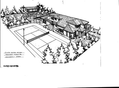 Hawthorn Historical Society
Drawing - Property Illustration, 17 & 17A Clifton Road, Hawthorn East
'After training as a Cartographic Draftsman within the mining industry, I worked as a property illustrator for real estate firms in the eastern suburbs of Melbourne for 23 years from 1983. I initially photographed houses with a Polaroid camera and made a 'thumbnail' sketch while there. The photos were used to scale off a sketch in pencil and then that sketch was overlaid with drafting film and the 'pen and ink' completed. The pens I used were the Rotring ‘Rapidigraph’ drafting pens. The ink was also made by Rotring (German).The film was ‘Rapidraw’, polyester drafting film, double matte. It takes a very fine line and doesn’t bleed. As well as house sketches, there were often floor plans and site plans ordered. Aerial sketches were ordered when the property needed an overall view.' (Margaret Picken, 2020)This property illustration is one of a series created by Margaret Picken for a range of real estate agents in Melbourne between c. 1983 and c. 2006. Each work is signed and dated by the artist.Gift of Margaret Picken, 2020Pen and ink property illustration on drafting film of 17 & 17A Clifton Road, Hawthorn East by Margaret Picken.17 & 17A Clifton Road, Haw, Margaret Picken '92. Woodards - C'well.artist - margaret picken 1950- -
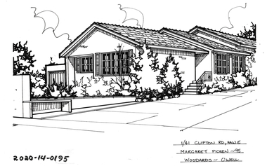 Hawthorn Historical Society
Drawing - Property Illustration, 1/ 41 Clifton Road, Hawthorn East
'After training as a Cartographic Draftsman within the mining industry, I worked as a property illustrator for real estate firms in the eastern suburbs of Melbourne for 23 years from 1983. I initially photographed houses with a Polaroid camera and made a 'thumbnail' sketch while there. The photos were used to scale off a sketch in pencil and then that sketch was overlaid with drafting film and the 'pen and ink' completed. The pens I used were the Rotring ‘Rapidigraph’ drafting pens. The ink was also made by Rotring (German).The film was ‘Rapidraw’, polyester drafting film, double matte. It takes a very fine line and doesn’t bleed. As well as house sketches, there were often floor plans and site plans ordered. Aerial sketches were ordered when the property needed an overall view.' (Margaret Picken, 2020)This property illustration is one of a series created by Margaret Picken for a range of real estate agents in Melbourne between c. 1983 and c. 2006. Each work is signed and dated by the artist.Gift of Margaret Picken, 2020Pen and ink property illustration on drafting film of 1/41 Clifton Road, Hawthorn East by Margaret Picken.1/41 Clifton Road, Hawthorn, Margaret Picken '95 Woodards - C'well. artist - margaret picken 1950- -
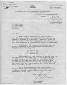 Ballarat Tramway Museum
Document - Letter/s, NSW Department of Road Transport and tramways, Letter from NSWT - re tramcars, 1939
Yields information about Sydney tramcars and that some trams were transferred to Ballarat in about 1907, but does not give detail.Letter to W. Jack dated 4/7/1939 from J. Ross, Secretary to the Department of Road Transport and Tramways NSW and attached handwritten list of tram classes, number and horsepower of motors red pencil and ink. Letter typed. Pages held together by brass pin clip folded out. Advises that some tramcars were sold to Ballarat about 1907. Record updated and images added 19/8/2013trams, tramways, sydney tramcars, rolling stock, ballarat -
 Whitehorse Historical Society Inc.
Newspaper - Article, Shafer Road, Blackburn, 15/02/1989
Article on 48 Shafer Road, Blackburn, built c1907, Nunawading Gazette, 15 Feb 1989.shafer road, blackburn north, auctions -
 Ballarat Heritage Services
Photograph - Colour, Clare Gervasoni, Kings Road, Marysville, 2012, 15/12/2012
A number of colour photographs showing Kings Road, Marysville after the 2009 'Black Saturday' bushfire.bushfire, black saturday, marysville, kings road -
 Tarnagulla History Archive
Photograph of Commercial Road, Tarnagulla, Commercial Road, Tarnagulla, circa 1960s
Murray Comrie Collection.Photograph of Commercial Road, Tarnagulla (northern end, looking south). Photo probably taken in the 1960s. tarnagulla, buildings, streets -
 Surrey Hills Historical Society Collection
Photograph, Entrance to Wattle Park from Riversdale Road, 1912-1914
Information provided by Stan Smith: Riversdale Road looking east 1912-1914. Wattle Park, then a farm is on the right. The near row of trees across the picture, indicates the driveway in Wattle Park. Wattle Park was then Fenwick's farm - or - Fennies to the local boys. Note: Riversdale Road becomes not much more than a track after passing the farm entrance.A dirt road in the lower left corner of the photograph is bounded by a post and rail fence. Two cyclists are on the road. "Wattle Park" is written to the right side of the road.wattle park, 1912, farms, 1914, fenwicks farm, fennies, fences, trees, roads and streets, riversdale road, pine trees, gum trees, cyclists -
 Stawell Historical Society Inc
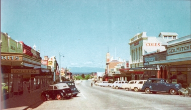
Photograph, Main Street Stawell looking West with Geo. Mitchell shop on the right c 1955 -- Coloured
Coloured photo c 1955 Main Street Scene looking West. Geo Mitchell Draper on right with Coles and Macrows. On the left E. Dale & Co. shop sign is visible. Either side of the street has cars parked at an angle with a soft canopy car parked on the left side.Colour photograph looking down Main St Stawell with the Grampians in the distance c 1955. This coloured photo has shops either side in view and cars parked at an angle along the street. Coles, Macrows and Geo. Mitchell shops are on the right and E. Dale & Co shop sigh is visible on the left.stawell business streetscape -
 Bacchus Marsh & District Historical Society
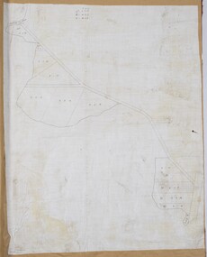
Map, Lerderderg Gorge Road Goodmans Creek to Gisborne Road
The date of this map and its purpose has not been established. It was possibly produced to indicate landholders who were impacted by works along the Lerderderg Gorge Road. A single page paper map showing various blocks of land along the route of the Lerderderg Gorge Road near Bacchus Marsh from Goodmans Creek to the point where the road joins with Gisborne Road. The map is pasted into a bound volume containing 76 maps or plans in total. High resolution digital image stored on BMDHS computer network. bacchus marsh victoria maps, lerderderg gorge road bacchus marsh maps -
 Glen Eira Historical Society
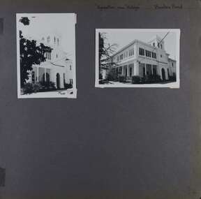
Album - Album page, Kynaston now Kahlyn, Bambra Road, Circa 1972
This photograph is part of the Caulfield Historical Album 1972. This album was created in approximately 1972 as part of a project by the Caulfield Historical Society to assist in identifying buildings worthy of preservation. The album is related to a Survey the Caulfield Historical Society developed in collaboration with the National Trust of Australia (Victoria) and Caulfield City Council to identify historic buildings within the City of Caulfield that warranted the protection of a National Trust Classification. Principal photographer thought to be Trevor Hart, member of Caulfield Historical Society. Most photographs were taken between 1966-1972 with a small number of photographs being older and from unknown sources. All photographs are black and white except where stated, with 386 photographs over 198 pages.https://vhd.heritagecouncil.vic.gov.au/places/35575 From: Glen Eira Heritage Management Plan (1996) by Andrew Ward and Associates Significance: "Kynaston" is locally important as a large late Victorian villa residence, demonstrating something of the lifestyle to which a senior government bureaucrat could aspire during the late nineteenth century boom period. The design of the verandah, though defaced, is unusual in Caulfield and, therefore, important. A substantial late Victorian stuccoed Bool11 style villa residence with tower surmounting the entrance porch, fluted columns to the ground level verandah and parapeted balcony over, now built in with a sympathetic addition at the north-west corner. The principal rooms and staircase are intact and representative of the period.Page 34 of Photograph Album with two portrait photographs of exterior of Kynaston - 2 views highlighting the front of the mansionHand written: "Kynaston" now "Kahlyn" Bambra Road [top right] / 34 [bottom right] trevor hart, caulfield north, bambra road, 1850's, mansion, villa residence, cast iron verandah, victorian, decorative brackets, slate roof, curved windows, 1880's, kynaston, kynaston l murray, kahlyn private hospital, kahlyn, return verandah, enclosed verandah, cast iron work, double storey mansions, towers, balconies -
 Glen Eira Historical Society
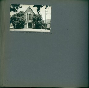
Album - Album page, Methodist Church, Bambra Road, 55, Circa 1972
This photograph is part of the Caulfield Historical Album 1972. This album was created in approximately 1972 as part of a project by the Caulfield Historical Society to assist in identifying buildings worthy of preservation. The album is related to a Survey the Caulfield Historical Society developed in collaboration with the National Trust of Australia (Victoria) and Caulfield City Council to identify historic buildings within the City of Caulfield that warranted the protection of a National Trust Classification. Principal photographer thought to be Trevor Hart, member of Caulfield Historical Society. Most photographs were taken between 1966-1972 with a small number of photographs being older and from unknown sources. All photographs are black and white except where stated, with 386 photographs over 198 pages.Page 37 of Photograph Album with one landscape photograph of the Methodist church.Handwritten: METHODIST CHURCH 55 BAMBRA ROAD 14 DEC 1972 / 37 [bottom left]trevor hart, caulfield north, bambra road, methodist church -
 Glen Eira Historical Society
Album - Album page, Crotonhurst, Hawthorn Road, Circa 1972
This photograph is part of the Caulfield Historical Album 1972. This album was created in approximately 1972 as part of a project by the Caulfield Historical Society to assist in identifying buildings worthy of preservation. The album is related to a Survey the Caulfield Historical Society developed in collaboration with the National Trust of Australia (Victoria) and Caulfield City Council to identify historic buildings within the City of Caulfield that warranted the protection of a National Trust Classification. Principal photographer thought to be Trevor Hart, member of Caulfield Historical Society. Most photographs were taken between 1966-1972 with a small number of photographs being older and from unknown sources. All photographs are black and white except where stated, with 386 photographs over 198 pages. Dr Geulah Solomon's 4 volume book "Caulfield's Heritage" Vol 1 p 35 "...an elaborate double-storey spreading mansion which brought together several architectural styles to create a fairytale castle effect...". Dr Solomon indicates that the mansion was demolished circa 1937.Page 76 of Photograph Album with two portrait photographs of Crotonhurst and its grounds.Handwritten: "Crotonhust " (dem) Hawthorn Road [top right hand corner] / 76 [bottom right]trevor hart, caulfield, architectural features, architectural styles, hawthorn road, crotonhurst, north caulfield, gothic, george henry frederick webb, george webb, 1860's, judge webb, mansion, semi circular spire, square turret, cornish entrance porch, isabella webb, cruden farm, stables, castle-like towers, j mclaughlin, glen eira road, walworth avenue, stained glass windows, organs -
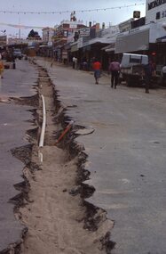
Glenelg Shire Council Cultural Collection
Photograph - Photograph - Main Breakwater construction, Portland, 04/12/1952
Port of Portland Authority ArchivesFront: MAIN BREAKWATER ACCESS ROAD 4.12.52 TRUST WORKS HOUSES IN BACKGROUND - Blackprint. Back: Square purple stamp - Print No 4/9 Neg No 81 Date Taken 4.12.52 Subjectport of portland archives, main breakwater, construction, portland, harbour, harbour development -
 Eltham District Historical Society Inc
Slide, In Bonds Road looking north at intersection with Montpelier Drive, Lower Plenty, 18 July 1972, 1972
Water drainage work undertaken by Eltham Shire Council in Bonds Road, Lower Plenty outside the Martin property opposite Montpelier Drive, July 1972 Note water flooding across Bonds Road and pile of material removed from the pit on the east side of Bonds Road.35 mm colour positive transparency Mount - Agfacolor Service (Blue)Bonds Road (Martin property) 12.10 pm 18.7.72bonds road, drainage works, eltham shire council, infrastructure, lower plenty, martin property, montpelier drive