Showing 11150 items
matching printers-blocks
-
 Canterbury History Group
Photograph - Street view of the corner of Maling Road and Bryson Street depicting the shop No. 92. Maling Road, Jan Pigot, 1994
Coloured photograph of the street view of the corner of Maling Road and Bryson Street depicting Buckley's Supermarket at shop No. 92. Maling Road This is also the corner of the building named The Block 1907.canterbury, maling road, shops, bryson street, buckley family, the block -
 Bendigo Historical Society Inc.
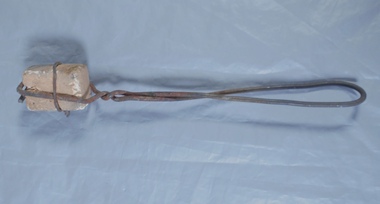
Functional object - Fire lighter
BHS CollectionA hand made fire lighter made with hand wrought fencing wire around a four centimetre by three centimetre by two centimetre block. Part of the Aileen and John Ellison Collectionaileen and john ellison, fire lighter -
Ringwood and District Historical Society
Certificate of Title, Certificate of Title of land in Summit Crescent, North Ringwood
Given to the Society by Marg ... Certificate of a title for a block of land in Summit Crescent, North Ringwood.Certificate of Title of land in Summit Crescent, North Ringwood: two white pages of original photocopied double sided. +Additional Keywords: Rushworth, Maggie -
 Eltham District Historical Society Inc
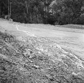
Negative - Photograph, J.A. McDonald, Heidelberg-Kinglake Road, Sep 1959
Job 56M430 Contractor Hone Wash over road due to blocked table drainRecord of various Shire of Eltham infrastructure works undertaken during the period of 1952-1962 involving bridge and road reconstruction projects, sometimes with Eltham Shire Council Project Reference numbers quoted. It was during this period that a number of significant improvements were made to roads and new bridges constructed within the shire that remain in place as of present day (2022). In many situations, the photos provide a tangible visible record of infrastructure that existed throughout the early days of the Shire. The album was put together by or under the direction of the Shire Engineer, J.A. McDonald.infrastructure, shire of eltham, bridge construction, 1959-09, heidelberg-kinglake road, road construction -
 Greensborough Historical Society
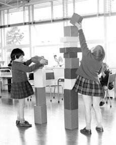
Photograph, Junior classroom, Janefield 1970, 1970
Photograph of Janefield Special School junior classroom, students building block towers, 1970.Black and white photographCaption on back: "Junior classroom, 1970"janefield, janefield special school -
 Federation University Historical Collection
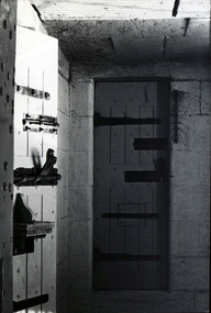
Photograph - Photograph - Black and White, Geoff Biddington, Ballarat Gaol Cell Door, 1967
The Ballarat Gaol Cell Block was situated at the end of Lydiard Street South. It was demolished c1968Black and white photograph of a heavily riveted gaol cell door with large bolts..ballarat gaol, cell door, hinge, bluestone, geoff biddington, cell block, bolt -
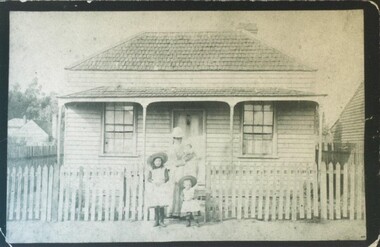 City of Ballarat Libraries
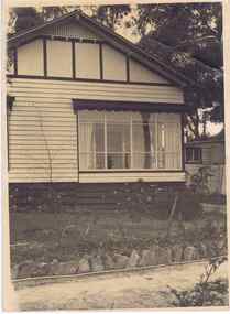
Photograph - Card Box Photographs, Mother and children stand out the front of a cottage in Otway Street North, Ballarat circa 1881
The cottage was the second block from Victoria Street and around the corner from Dytes Parade.building, private dwelling, people, costume, otway street -
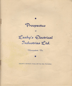 Warrnambool and District Historical Society Inc.
Document, Prospectus (Leahy’s Electrical), 1951
This is the 1951 prospectus of the new company known as Leahy’s Electrical Industries Limited and formed from the previous business of Jim Leahy, Electrical Engineer. The business was then and remains today at 82 Fairy Street, Warrnambool . The business of Jim Leahy had been operated in conjunction with Leahy’s Hire Cars and commenced in 1946. This was initially a good business with 25 employees but the building stock and plant were destroyed by fire in 1950 with the business continuing on a limited scale until the new company in 1951 was formed. Jim Leahy purchased the freehold at the corner of Liebig and Koroit Streets and the business prospered from there but today it is based back in Fairy StreetThis prospectus is of some significance as it signals the start of the important business in Warrnambool today of Leahy’s Electrical. The prospectus shows that the original directors were Leahy, Dwyer, Walter, Croft, White and Affleck and they were prominent Warrnambool and district people at that time. This prospectus also has a good summary of the history of the Leahy business up to 1951 and the financial statements etc are of considerable importance to researchers and other readers. This is a typed prospectus of six pages printed back to back and with a buff-coloured cover of lightweight card. The printing on the cover is dark blue. Front Cover: ‘Prospectus of Leahy’s Electrical Industries Ltd, Warrnambool, Vic, Collett & Munday, Printers, 254 Timor Street, Warrnamboolleahy’s electrical, jim leahy, leahy's electrical prospectus, warrnambool -
Glenelg Shire Council Cultural Collection
Photograph - Photograph - Julia Street Porrtland, c. 1970
Photographic print of a rephotographed photograph. Image of north side of Julia Street between Percy and Bentinck Streets. Bluestone buildings - Woolstores of Henty, Learmonth & Co, Bank of Australasia on right. Numerous people on footpath.Front: 'Henty Woolstore - 2 Observer Buildings, Julia Street' - green ink Back: 'Bayview and Observer Printers' - blue biro -
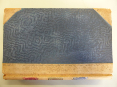 Warrnambool and District Historical Society Inc.
Document - Ledger: Correspondence and reports Country Roads Board , Shire of Warrnambool 1914-1925, Circa 1914
The letters contained within this ledger provide an overview of correspondence which occurred around matters such as roadmaking and maintenanceProvides a detailed record of correspondence relating to engineering matters in the shire and surrounds and also a comprehensive list of organisations associated with this work.Dark blue watermarked cover with fawn suede binding and corners. Spine has three coloured rectangles with the following in each: Correspondence and reports, Country Roads Board and Shire of Warrnambool. There is an index at the front and the ledger contains copies of correspondence relating to roads, maintenance and infrastructure.Inserted in ledger is1) typed invoice from The Government of Victoria to Shire of Warrnambool for 1915/16, 2) Original of two pages showing list of contracts on Garvoc Laang Road. Arnall and Jackson, Engravers and Lithographers. Printers and Manufacturing stationers 478 Collins Street, Melbourne. No B 22065 23/09/14. warrnambool, warrnambool shire engineer, shire correspondence, crawley, road works, bridges, bitumen roads, 1914-1925, country roads board -
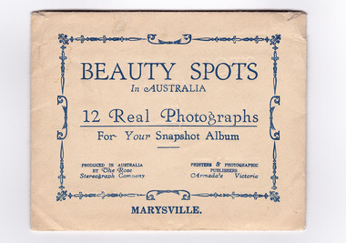 Marysville & District Historical Society
Photograph (item) - Black and white photographs, Rose Stereograph Company, Beauty Spots In Australia-Marysville, 1913-1967
An envelope with 12 black and white photographs of scenic attractions taken in and around Marysville in Victoria. An envelope with 12 black and white photographs of scenic attractions taken in and around Marysville in Victoria. The photographs were used for a series of photographs and postcards published by the Rose Stereograph Company in Armadale, Victoria.12 Real Photographs/ For Your Snapshot Album PRODUCED IN AUSTRALIA/ BY The Rose/ Stereograph Company PRINTERS & PHOTOGRAPHIC/ PUBLISHERS/ Armadale, Victoriakeppel falls (image 1), cumberland falls (image 2), track to cora lynn falls (image 3), nichol's lookout (image 4), cameron cascades (image 5), stevenson falls (image 6), taggerty river (image 7), main street (image 8), taggerty river (image 9), talbot drive (image 10), cora lynn falls (image 11), taggerty river (image 12), rose series postcard, rose stereograph company, souvenir -
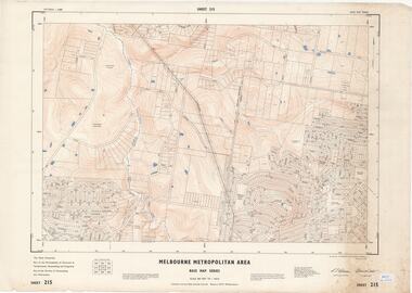 Ringwood and District Historical Society
Map - Melbourne Metropolitan Area Base Map Series, Sheet 215 - Ringwood area, 1967
Map prepared by Dept of Lands and Survey and MMBW from State Aerial Survey June 1957 and Cadastral Survey information July 1967. This sheet comprises parts of Municipalities of Doncaster & Templestowe, Nunawading and Ringwood, and Parishes of Nunawading and Warrandyte.Scale: 400 feet to 1 inch. Contours at 5 feet vertical interval. By Authority: A.C. Brooks, Commonwealth Printer, Melbourne. -
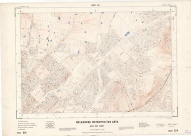 Ringwood and District Historical Society
Map - Melbourne Metropolitan Area Base Map Series, Sheet 216 - Ringwood area, 1967
Map prepared by Dept of Lands and Survey and MMBW from State Aerial Survey June 1957 and Cadastral Survey information July 1967. This sheet comprises parts of Municipalities of Croydon, Doncaster & Templestowe, and Ringwood, and Parishes of Ringwood and Warrandyte.Scale: 400 feet to 1 inch. Contours at 5 feet vertical interval. By Authority: A.C. Brooks, Commonwealth Printer, Melbourne. -
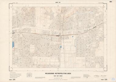 Ringwood and District Historical Society
Map - Melbourne Metropolitan Area Base Map Series, Sheet 235 - Ringwood area, 1960
Map prepared by Dept of Lands and Survey and MMBW from State Aerial Survey June 1957 and Cadastral Survey information August 1960. This sheet comprises parts of Municipalities of Doncaster & Templestowe, Nunawading and Ringwood, and Parishes of Nunawading, Ringwood and Warrandyte.Scale: 400 feet to 1 inch. Contours at 5 feet vertical interval. By Authority: A.C. Brooks, Commonwealth Printer, Melbourne. -
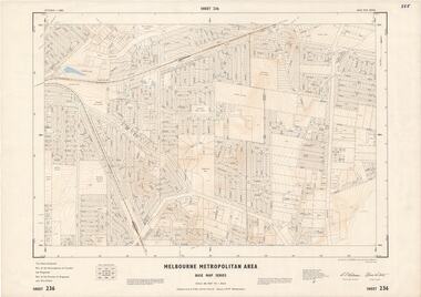 Ringwood and District Historical Society
Map - Melbourne Metropolitan Area Base Map Series, Sheet 236 - Ringwood area, 1961
Map prepared by Dept of Lands and Survey and MMBW from State Aerial Survey June 1957 and Cadastral Survey information May 1961. This sheet comprises parts of the Municipalities of Croydon and Ringwood, and Parishes of Ringwood and Warrandyte.Scale: 400 feet to 1 inch. Contours at 5 feet vertical interval. By Authority: A.C. Brooks, Commonwealth Printer, Melbourne. -
 Ringwood and District Historical Society
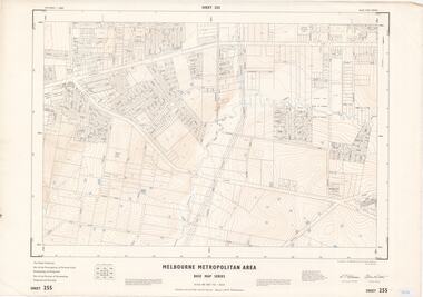
Map - Melbourne Metropolitan Area Base Map Series, Sheet 255 - Ringwood area, 1963
Map prepared by Dept of Lands and Survey and MMBW from State Aerial Survey December 1956 and Cadastral Survey information May 1963. This sheet comprises parts of the Municipalities of Ferntree Gully, Nunawading and Ringwood, and Parishes of Nunawading, Ringwood and Scoresby.Scale: 400 feet to 1 inch. Contours at 5 feet vertical interval. By Authority: A.C. Brooks, Commonwealth Printer, Melbourne. -
 Ringwood and District Historical Society
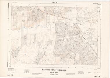
Map - Melbourne Metropolitan Area Base Map Series, Sheet 256 - Ringwood area, 1962
Map prepared by Dept of Lands and Survey and MMBW from State Aerial Survey December 1956 and Cadastral Survey information December 1962. This sheet comprises parts of the Municipalities of Croydon, Ferntree Gully, and Ringwood, and Parishes of Ringwood and Scoresby.Scale: 400 feet to 1 inch. Contours at 5 feet vertical interval. By Authority: A.C. Brooks, Commonwealth Printer, Melbourne. -
Port Melbourne Historical & Preservation Society
Photograph - Old tin shed', sugar warehouse, corner Rouse and Johnston Streets, Port Melbourne, Peter Libbis, 31 Jan 1998
Peter LIbbis shot this when the builidng had been put up for sale after area was rezoned. Building once associated with sugar industry and Joshua Bros distillery near by.One of three photos of the 'old tin shed', sugar warehouse at northwest corner Rouse and Johnston, January 1998: exteriorPrinter's imprint on back; dated front; 'Rouse Str. North side cnr Rouse and Johnson Sts' in marker pen on backbuilt environment - industrial -
Port Melbourne Historical & Preservation Society
Book - Borough of Port Melbourne Valuation, 1893
Valuation book, Borough of Port Melbourne 1893. Solid bluegreen cloth cover with maroon spine, gold-stamped. 177 spreads completed listing name and occupation of tenant and owner of each property, description, number of rooms, size of property, rental etc. (also Rates; assessments) p 181: "701.180 taken out for for printers copy 10/9/94 F.C.C" Signed p177 by Mayor and Town Clerk.local government - borough of port melbourne, built environment, edward c crockford, town clerks, john finlay malcolmson, joseph turner -
 Bendigo Historical Society Inc.
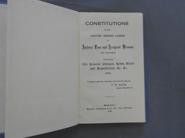
Book - JOHN FREDERICK HARPER COLLECTION: CLOTH BOUND BOOK, 1962
Book. Small book, bound and cover of blue cloth, on the front cover of which is ,printed in gold lettering: Victoria Constitutions 1962. Inside is printed : Constitutions of the United Grand Lodge of Ancient Free and Accepted Masons, Containing The General Charges, Laws Rules and Regulations.&c, &c 1962.Published under the Authority of the Grand Lodge by C.E.Davis Grand Secretary, Melbourne. Harston, Partridge & Company Pty Ltd Printers 1962.book, masonic, victorian constitutions 1962 -
 Bendigo Historical Society Inc.
Map - JACK FLYNN COLLECTION: ARCHDALE, 15/01/1936
Map: Parish of Archdale, County of Gladstone. Parish plan. The Allotments have been coloured in with pencil.By Authority H.J. Green, Government Printer Melbourne. Drawn and Reproduced at the Dept, of Lands and Survey, Melbourne, Victoria. 15/01/36map, gladstone, parish plan, archdale , gladstone -
 Bendigo Historical Society Inc.
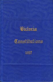
Book - LODGE COLLECTION: LANDMARKS OF THE ORDER
United Grand Lodge. Ancient Free and Accepted Masons book of the constitutions.Published under the authority of the Grand Lodge by Wm. Stewart, Grand Secretary. Harston, Partridge & Co. Pty Ltd., Printers. Melbourneorganisation, masonic lodge, victoria constitutions 1927 -
Port Melbourne Historical & Preservation Society
Book - Town of Port Melbourne Valuation, 1899
Valuation book, Town of Port Melbourne 1899. Dark grey with maroon spine and label gold-stamped. 71 spreads completed, listing name and occupation of tenant and owner of each property, description, number of rooms, size of property, rental etc. p72/3 removed, folded and placed in p73. (also Rates; assessments)"page 72-73 out for printers copy 29/9/00 ECC" on p73 Separate printers copy has order/instruction for next book in pencil, various markings on pages in pencil and in red ink (the latter indicating cross streets) Signed by Mayor, Town Clerk and an unidentifiable Councillorlocal government, built environment, joseph turner, edward c crockford, town clerks, henry norval edwards -
 Greensborough Historical Society
Photograph - Digital image, Jessie Partington's house, Carnon Street, 1940c
This house in Carnon Street Greensborough was the home of Jessie Partington. It was demolished around 2005 for a block of units.Digital copy of black and white photograph.jessie may partington, jessie angus, jessie scholes, carnon street -
 Federation University Historical Collection
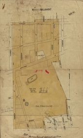
Plan, Ballaarat No 5722, 28/11/1903
Part of the block shaded yellow on the plan contains Phoenix P-12 School Senior CampusPlan of Ballarat with leae area No 5722 coloured yellow. Plan of the streets around Hertford Street, ballarat. The yellow depicts the area leased (No 5722 Ballarat)mining lease 5722 ballarat, ballarat, hertford street, cromwell street, alexandra street, alfred street, verdon street, clarkson street, spencer street, franklin street, hill street, grant street, albion street, rowlands street, edwards street north, mining, cgt, plans, phoenix p-12 school senior campus -
 Melbourne Tram Museum
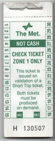
Ephemera - Ticket/s, The Met, Block of The Met, Check tickets, Zone 1, 1995
Block of The Met, Check tickets, Zone 1, issued in conjunction with the use of a prepaid short trip ticket. Green printing on white paper with the numbers 1 to 30 along the sides. Has the 2nd generation The Met logo. Ticket numbers H130507 to 130550. Block stapled with two staples to a sheet of cardboard and paper retaining strip along the top edge. See Reg items 53, 975 and 1041 for associated information and their use.trams, tramways, check ticket, short trip tickets, the met, tickets -
 Melbourne Tram Museum
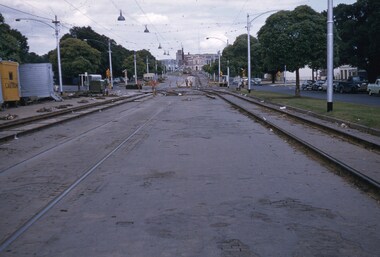
Slide, Keith Kings, 15/08/1959 12:00:00 AM
Colour slide, Kodak, white cardboard of track reconstruction in Flemington Road, North Melbourne 19/12/1959, over Grattan St, with trams 935 and 927 in the far distance. Note the wood block construction, the austerity bus, the hotel in the far distance on the corner of Elizabeth St and Peel St, the trees are blocking the view of the former Haymarket, the temporary track relaying and the lone watchman or "traffic controller". Slide Number K(l)(289)Extensive handwriting on rear in ink and that it was photographed at 1/60 f5.6.trams, tramways, flemington rd, grattan st, trackwork, track construction, tram 935 -
 Ballan Shire Historical Society
Map - Map. Shire of Ballan, Shire of Ballan
This is a fairly comprehensive map of the former Shire of Ballan which is now amalgamated into the Shire of Moorabool.A black and white map of the Shire of Ballan showing major roads, rivers, towns, settlements, State parks and forests and land subdivisions. It appears to be a copy of the original as no dates or maker or printer appear on the map. There is a scale of 2 miles to 1 inch.gordon, ballan, bungal, kerrit bareet, borhoneyghurk, bungeeltap, ballark, yaloak, gorong, beremboke, wallace, ingliston, hunterston, millbrook, bradshaw, myrniong, blackwood, moorarbool, greendale, bayup, trentham, bullarto, korweinguboora, glenlyon, bolwarra -
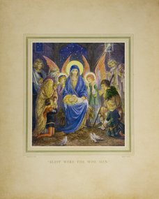 Mission to Seafarers Victoria
Print - Reproduction of a painting, Blest Were The Wise Men by Daphne Allen, Early 20th Century
Little known as this print was discovered in an old cabinet in the vestry of the Chapel of St Peter. Possibly a donation meant to be framed or possibly an item used at Port Melbourne Mission which at times ran Sunday school services at the turn of the 19th and 20th C.Allen a child prodigy was a significant popular religious artist. This print is a good example of her work.Appears to be a fine quality full colour reproduction of a nativity scene with angels wise men and madonna in the style influenced by late Pre -Raphaelites mounted on heavy card with printed name of artist at left and printer initials at right and title in centre. see imagenativity scene, daphne allen, artwork-paintings