Showing 8492 items
matching snowy-river-dry-cleaners
-
 University of Melbourne, Burnley Campus Archives
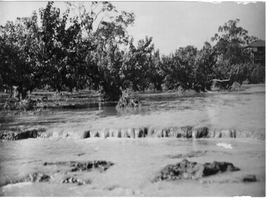
Photograph - Black and white print, Orchard in Flood, 1934
Black and white photograph. Orchard in floodOn reverse, "Orchard Yarra River in flood Dec 1934."orchard, yarra river, floods, 1934 -
 University of Melbourne, Burnley Campus Archives
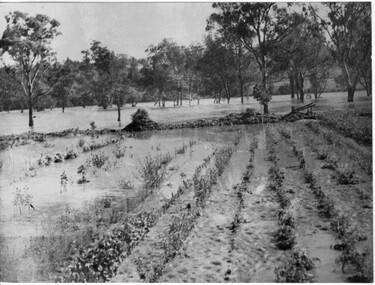
Photograph - Black and white print, Orchard in Flood, 1934
Black and white photograph. Orchard in flood. Seedlings planted in rows.On reverse, "Orchard Yarra River in flood Dec 1934."orchard, yarra river, floods, 1934 -
 University of Melbourne, Burnley Campus Archives
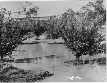
Photograph - Black and white print, Orchard in Flood, 1934
Black and white photograph. Orchard in flood: shows fruit trees standing in water.On reverse, "Orchard Yarra River in flood Dec 1934."orchard, yarra river, floods, 1934, fruit trees -
 University of Melbourne, Burnley Campus Archives
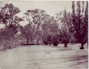
Photograph - Black and white print, Orchard in Flood, 1934
Black and white photograph. Orchard in floodOn reverse, "Orchard Yarra River in flood Dec 1934."orchard, yarra river, floods, 1934 -
![Photograph - Construction of the F19 [Eastern Freeway], Ron Setford, May 1976](/media/collectors/550653872162f11fb04854aa/items/6815afa28b33318343789e1c/item-media/6815afc88b33318343789fc9/item-fit-380x285.jpg) Kew Historical Society Inc
Kew Historical Society IncPhotograph - Construction of the F19 [Eastern Freeway], Ron Setford, May 1976
Ron Setford and his wife Grace Setford lived in Tanner Avenue, East Kew, from c.1946 to c.1995. A keen photographer, he recorded the changing face of Kew over a 20 year period. Apart from 30 photographs of built structures and places in Kew dating from 1960 and 1961, 145 of his 35mm colour slides chronicle the development of the F19 (later renamed Eastern) Freeway through the Yarra Valley in Kew over a five year period from c.1972 to c.1977. This important collection was donated to the Society by his granddaughter in 2025.This collection of 175 35mm slides is of local and statewide significance, owing to its subject matter, particularly the major development of road transport infrastructure during the 1970s with the construction of the Eastern Freeway. The photographer also took care to annotate and date most of his slides which enable the researcher to pinpoint temporal and spatial locations."Main bridges over Yarra River / Kew - Fairfield"ron setford, eastern freeway, f19 freeway -
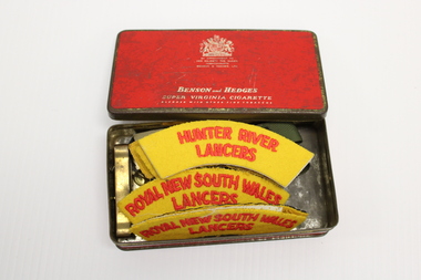 National Vietnam Veterans Museum (NVVM)
Uniform - Epaulettes
Part of the estate collection of Vietnam veteran Sgt T J Nicholson, Service no: 4410261, who served in 1st Armoured Regiment, Vietnam 1969-70.24 items ranging from epaulettes, badges and belt metal.Hunter River/Rural New South Wales/Lancerstj nicholson, 1st armoured regiment, epaulettes, nicholson, trevor nicholson, 4410261 -
![Photograph - Construction of the F19 [Eastern Freeway], Ron Setford, May 1976](/media/collectors/550653872162f11fb04854aa/items/6828796a64071e7c58e65b49/item-media/682879ac64071e7c58e65d0b/item-fit-380x285.jpg) Kew Historical Society Inc
Kew Historical Society IncPhotograph - Construction of the F19 [Eastern Freeway], Ron Setford, May 1976
Ron Setford and his wife Grace Setford lived in Tanner Avenue, East Kew, from c.1946 to c.1995. A keen photographer, he recorded the changing face of Kew over a 20 year period. Apart from 30 photographs of built structures and places in Kew dating from 1960 and 1961, 145 of his 35mm colour slides chronicle the development of the F19 (later renamed Eastern) Freeway through the Yarra Valley in Kew over a five year period from c.1972 to c.1977. This important collection was donated to the Society by his granddaughter in 2025.This collection of 175 35mm slides is of local and statewide significance, owing to its subject matter, particularly the major development of road transport infrastructure during the 1970s with the construction of the Eastern Freeway. The photographer also took care to annotate and date most of his slides which enable the researcher to pinpoint temporal and spatial locations."Poplars by Kilby Rd on what used to be the river bank"ron setford, eastern freeway, f19 freeway -
![Photograph - Construction of the F19 [Eastern Freeway], Ron Setford, May 1976](/media/collectors/550653872162f11fb04854aa/items/6828751564071e7c58e648e2/item-media/6828755564071e7c58e64940/item-fit-380x285.jpg) Kew Historical Society Inc
Kew Historical Society IncPhotograph - Construction of the F19 [Eastern Freeway], Ron Setford, May 1976
Ron Setford and his wife Grace Setford lived in Tanner Avenue, East Kew, from c.1946 to c.1995. A keen photographer, he recorded the changing face of Kew over a 20 year period. Apart from 30 photographs of built structures and places in Kew dating from 1960 and 1961, 145 of his 35mm colour slides chronicle the development of the F19 (later renamed Eastern) Freeway through the Yarra Valley in Kew over a five year period from c.1972 to c.1977. This important collection was donated to the Society by his granddaughter in 2025.This collection of 175 35mm slides is of local and statewide significance, owing to its subject matter, particularly the major development of road transport infrastructure during the 1970s with the construction of the Eastern Freeway. The photographer also took care to annotate and date most of his slides which enable the researcher to pinpoint temporal and spatial locations."Boulevard overpass by Fairfield river bdge / Dillingham contractor"ron setford, eastern freeway, f19 freeway -
 Slovenian Association Melbourne
Wooden dust beater, Marcela Bole dust beater
In Slovenia, there were no vacuum cleaners until 1970s to perform the jobs so housewives have been beating the dust out of mattresses, blankets and carpetsA woven wooden(willow wood tied together with wire) dust beater to be used in spring cleaning for beating the carpets, mattresses and blankets, dust beater, willow wood, cleaning mattresses, blankets, carpets -
 Kew Historical Society Inc
Photograph - Studley Park, 1937
Those sections of Studley Park closest to the River Yarra were set aside as parkland in the 1850s. After initial discussions about whether it was a suitable site for a Government House, much of the land was instead gazetted in the 1860s as the location for a new lunatic asylum, to expand overcrowded mental health facilities at the Yarra Bend Asylum on the other side of the river at Fairfield. Those sections of Studley Park bounded by the Yarra River, Studley Park Road, Princess Street and Fellows Street were subdivided and sold at the Crown Land Sales in 1851. Much of this urban area remained open farmland until the twentieth century, apart from mansions, largely located along the main roads.Original, black and white positive print of what is said to represent Studley Park in 1937. If the attribution and date is literally to be understood, then it would appear that the photograph may have been taken from the Kew side of the river looking across to open farmland in the Yarra Bend Park. If the designation of Studley Park is to be understood more loosely, then it might be a view of what is now East Kew, taken from a section of Kilby Road. Inscribed verso: "Studley Park 1937" studley park -- kew (vic.) -
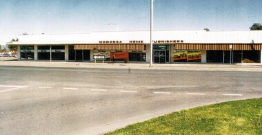 Wodonga & District Historical Society Inc
Photograph - Wodonga Business - Wodonga Home Furnishers
This popular furniture business was owned and operated by Mr Les Cheesley. In about 1963 the premises of Birrell's Bakery, Miss Hamilton's Corsetry, Gouge's Dry Cleaners, and the Dalgety NZ Loan Stock & Station Agents were demolished to make way for the Wodonga Home Furnishers. Mr Cheesley was a well-respected member of the community and served 13 years as a local councillor. He was often referred to as the council’s watchdog. His contribution is commemorated in the naming of the Les Cheesley Oval, Wodonga in his honour. Mr Cheesley died in Wodonga on 29th September 1994. The business continued to operate for a few more years but the shop was demolished in 1999 to make way for the realignment of Elgin Street in central Wodonga.A colour photo of the premises of Wodonga Home Furnishers in High Steet, Wodongawodonga businesses, high street wodonga, wodonga home furnishers, les cheesley -
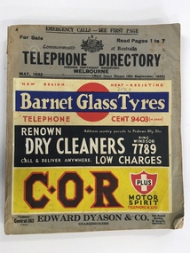 Warrnambool and District Historical Society Inc.
Book, Telephone Directory Melbourne May 1933, 1933
This is a telephone directory of the telephone numbers and addresses of residents and businesses in Melbourne in 1933. There had been several early attempts in the second half of the 19th century to link places and homes in Victoria by locally-made telephone systems with a commercial telephone system in the same year successfully linking a business in Melbourne to a branch office in the same city. The first telephone exchange in Australia was established in Melbourne in 1880. This 1933 telephone directory shows the growing number of private residents and businesses to have the telephone installed but the installations were still confined mostly to the more affluent private residents and to businesses. This book is of considerable interest as a reference guide as it provides the names and addresses of those who had a telephone installed in Melbourne in 1933. This will be of great use to researchers, especially those compiling their family tree. This is a soft cover book of 364 pages. It has a buff-coloured cardboard cover with the title and other printed information on the front cover and four multi-colour advertisements for Melbourne businesses (Barnet Glass Tyres, Renown Dry Cleaners, C.O.R. Motor Spirit and Edward Dyason, Sharebrokers), also on the front cover. The back cover has a colour advertisement for Gilbey’s Gin. The pages listing the householders’ telephone numbers and addresses in alphabetical order are white with black printing and there are 20 pink pages at the back (business and professional listings). The book has been bound with glue. The cover is somewhat crumpled and the pages are dog-eared. melbourne history, telephone installation history in victoria, warrnambool, history -
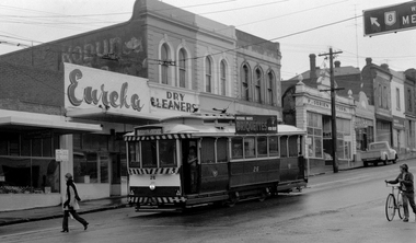 Ballarat Tramway Museum
Photograph - Digital image, 1970s
Yields information about the Bakery St Hill on the Victoria St route.Digital image, black and white, of No. 26 at Stones Corner, junction of Bridge, Victoria and Main St, Bakery Hill. No the young girl in slacks walking in front of the tram, the boy wheeling the bike down the street and the young boy standing in the front door of the tram. In the background is Eureka Dry Cleaners, an old Robur tea ad on a building, F. O'Brien Motors. The tram has the destination of Gardens via Sturt St West and a SEC Briquettes Roof advert. Photo taken by Peter Bruce 1970's and 1971, prior to the closure of the Ballarat tramway system. Peter's Title of image: "No. 26 Victoria and Bridge"trams, tramways, stones corner, bakery hill, victoria st, bridge st, tram 26 -
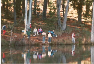 Sunbury Family History and Heritage Society Inc.
Photograph, School Camp, 1988
The children from Mickleham and Bulla Primary Schools were attending a school camp near Beechworth and were visiting a trout farm.A non- digital coloured photograph of a group of children by a river. Three people are standing very close to the edge, while the rest of the children are sitting further up on the river bank.school camps, beechworth -
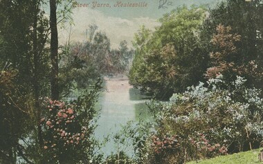 Bendigo Historical Society Inc.
Postcard - Alice McGregor Postcard Collection, 1900 - 1920
Alice McGREGOR Born: 1908; unknown parents. Possibly adopted by the Salter family? Electoral Roll 1936: Highland Terrace Kangaroo Flat. Alice Mary Salter and William Robert Salter living together; presumed to be sister and brother. William Robert Salter was killed in a MVA in Bendigo in 1937 aged 26. In Victoria in 1938, Alice Mary Salter married James Thomas McGregor (born Victoria 1917, died Victoria 1983, buried Fawkner Cemetery) Lived: 1968; 22 Wade Street Golden Square Alice McGregor Died: 1999 aged 91 at Anne Caudle Centre, Bendigo Buried: Kangaroo Flat Cemetery See additional research. Postcard Album of Alice McGregor contained 86 post cards.Postcard Album of Alice McGregor containing 86 post cards. See 1400. Colour photo of the Yarra River at Healesville, Victoria. Banks of the river has shrubs in flower. Addressed to Miss A. Stapleton, Arcade, Bendigo Post office cancellation stamp dated 18.11.05, Melbourne postcard, collector, alice mcgregor -
 Lakes Entrance Historical Society
Book, North East Regional Tourist Authority, North East Victoria, 1980
A brief record of the region from the Murray River in the north to the Dargo High Plains in the south, from Yarrawonga and Wangaratta in the west to the Indi River in the east. Illustrated with coloured photographs.tourism, mines and mining, settlers, water supply -
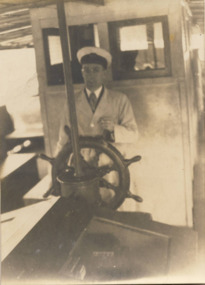 Kew Historical Society Inc
Photograph - Hicks Bros Motor Launch, circa 1953
Commercially-operated boat tours on the Maribyrnong and Yarra Rivers in Melbourne were a major tourist attraction, especially in the first half of the twentieth century. A number of companies ran ferries and motor-launches to locations such as the Riverview Tea Gardens (1909-1947) at Ascot Vale, and the Hawthorn Tea Gardens on the corner of Power Street and Riversdale Road. One of the families which ran these services was Hicks Bros, which from circa 1921 operated a ferry service from Princess Walk (Melbourne) to Studley Park. This is one of a series of 17 black and white undated photographic proofs donated to the Kew Historical Society in 2013 by the Queenscliffe Historical Museum. The series includes images of individuals, tea rooms, ferries, motor launches, ocean liners and tugs. In 1953, the owner of Hicks Bros was involved in an inquest into the drowning of a Ukrainian tourist on a ferry operated by Melbourne Ferries, a rival firm. In published reports of the inquest, reference is made to a number of photographs taken by Robert Irvine Atchison, part-owner of Hicks Bros. As the reverse of the photographs indicates copyright is held by the State of Victoria, the collection may have derived from that year.Historically significant and rare image of one of the major tour boat services which operated on the Yarra River.Faded black and white photographic proof of worker of a ferry service, steering a ferry on the Yarra River. He wears a captain's peaked hat and a coat.ferries, motor launches, yarra river, studley park, princess walk, hawthorn tea gardens, tourism - melbourne (vic.), hicks bros, hicks bros launches -
 Port of Echuca
Colour Photograph, 1978
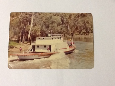
P. S. PEVENSEY: Dimensions: 111ft 5 ins X 23 ft X 6ft 8 ins. Tonnage:130 tons Built: 1910 at Moama, N. S. W. References : Book: Murray river Paddle Steamers by D. Wardle Permewan , Wright & Co. : pp. 72, 129, 157 The P. S. PEVENSEY holds historical and social significance for the Port of Echuca, being the cornerstone of their paddlesteamer fleet. The PEVENSEY was renamed for the TV series All the Rivers Run, to P. S. Philadelphia , playing a staring role in the program, which has resulted in the PEVENSEY becoming a tourist attraction and has increased tourism to the Port of Echuca. The PEVENSEY was originally designed for use on the Murrumbidgee river, named after Pevensey station on that river. It was then owned by Permewan Wright & co operating out of Echuca for many years. She returned to Echuca in 1975 to begin another life as part of the Port of Echuca tourism operation.Colour photograph of the P. S. Pevensey, taken from the water, looking at the rear of the boat. There are people (all in red jackets with a logo on the back-Port of Echuca workers?), some on the bow and 2 on the stern of the boat as it steams along the river. In front of the PEVENSEY is a small row boat with a group of people in it.On the front:PEVENSEY on the back of the boat. Printed on reverse: This paper manufactured by Kodak: Print made by Kodak: KODAK: OCT.78-Mriverboats, p.s.pevensey, echuca, port of, paddle steamers, echuca wharf -
 Otway Districts Historical Society
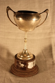
Trophy, Otway Tennis Association, B Section, c.1962
Otway Tennis Assn, B Section, tennis trophy. Cup-shaped EPNS with handles, bakelite base, with one rectangular plate and three shield plates with the names of winning teams from 1963 until 1991/92.;1963 Beech Forest 1964 Ferguson 1975 Beech Forest 1976 Beech Forest 1977 Beech Forest 1980 Carlisle River 1981 Carlisle River 1982 Lavers Hill 1982/83 Carlisle River 1983/84 Ferguson 1984/85 Lavers Hill 1985/86 Carlisle River 1986/87 Wyelangta 1987/88 Carlisle River 1990/91 Lavers Hill Green 1991/92 Weeaproinahtennis; trophy; otway tennis association; -
![View of the Township of Omeo / [by] Nicholas Caire, circa 1876](/media/collectors/550653872162f11fb04854aa/items/57830e80d0cdd1176c4335ca/item-media/57830eecd0cdd1176c43dd40/item-fit-380x285.jpg) Kew Historical Society Inc
Kew Historical Society IncPhotograph, Anglo-Australasian Photographic Company, View of the Township of Omeo, c. 1876
Nicholas Caire was born on Guernsey in the Channel Islands in 1837. He arrived in Adelaide with his parents in about 1860. In 1867, following photographic journeys in Gippsland, he opened a studio in Adelaide. From 1870 to 1876 he lived and worked in Talbot in Central Victoria. In 1876 he purchased T. F. Chuck's studios in the Royal Arcade Melbourne. In 1885, following the introduction of dry plate photography, he began a series of landscape series, which were commercially successful. As a photographer, he travelled extensively through Victoria, photographing places few of his contemporaries had previously seen. He died in 1918. Reference: Jack Cato, 'Caire, Nicholas John (1837–1918)', Australian Dictionary of Biography.An original, rare photograph from the series 'Views of Victoria: General Series' by the photographer, Nicholas Caire (1837-1918). The series of 60 photographs that comprise the series was issued c. 1876 and reinforced a neo-Romantic view of the Australian landscape to which a growing nationalist movement would respond. Nicholas Caire was active as a photographer in Australia from 1858 until his death in 1918. His vision of the Australian bush and pioneer life had a counterpart in the works of Henry Lawson and other nationalist poets, authors and painters.‘View of the township of Omeo’ : Views of Victoria (General Series) No.44 : Albumen silver photograph | Photo on card with Title and Description on reverse | Mounted 24 x 30 cm; Photo 12 x 17 cm.On Reverse: ‘The subject of this illustration is the most remote Township in the Colony of Victoria, being about 250 miles distant from Melbourne. It is situated on the Australian Alps, near Mt. Livingstone. The bed of the River, which is seen on the right-hand side of the picture, is one of the sources of the Mitchell River, which empties itself in the Gipps Land Lakes. This Township is frequently covered with snow in winter time, owing to its being several thousand feet above the level of the sea.’ nicholas caire (1837-1918), omeo (vic), gippsland, mount livingstone, australian alps -
City of Kingston
Photograph - Colour, c. 1993
Patterson Lakes is a suburb in the City of Kingston that is built one kilometre upstream of the mouth of the Patterson River. The area is bordered by the Patterson River and Eel Race Drain which enters the Kananook Creek. The suburb consists predominantly of newer housing developments and the tidal canal system of the development joins Port Phillip Bay.Patterson Lakes and the Kananook Creek were previously part of the extensive Carrum Carrum Swamp. The area was once a source of fish and eels for the Mayone-Bulluk clan of the Bunurong people. Over time the area was drained and in 1973 investigations commenced into the development of a unique residential area that would be built adjacent to canals and waterways. It was originally proposed to be known as "Gladesville". The development would give the suburb's homeowners access to Port Phillip Bay "from their back door". Circa 1974, the area was rezoned from rural to residential and named Patterson Lakes. Development has been continuous since the 1970s with construction of residential housing, schools, shopping centres, marinas, a hotel and library.Laminated colour aerial photograph of the Carrum and Patterson Lakes region within City of Kingston. This 1993 image includes Patterson River Secondary College, Roy Dore Reserve, Kananook Creek and Nepean Highway. The railway line can be seen as it veers inland from Eel Race Road, Seaford. The section of Palm Beach Drive, Curlew Point Drive, Snapper Point Drive, Clipper Island and Myola Street in Patterson Lakes appears to be a recent development with many spare blocks and new houses under construction.patterson lakes, seaford, kananook creek, carrum carrum swamp, canals and waterways -
 Glenelg Shire Council Cultural Collection
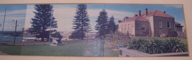
Photograph - Photograph - Panorama, 1987
Panorama of 7 colour photos. View of Municiple Offices over bay. Shows History House, Cannons, Charles Street, War Memorial and Court House.Back: For History House - Taken 1987 while employed as cleaner for City Council/Regards/Robert (?) Morris.... (?) (blue pen, upper centre) -
 Ballarat Tramway Museum
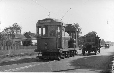
Photograph - Scrubber 8, Caulfield Junction, 24-8-1950
Black and white photograph of MMTB Scrubber No 8 at Caulfield Junction. No details as to the photographer. Taken 24-8-1950. This tram is the BTM's track cleaner or scrubber.Yields information about the use of Scrubber tram No. 8Photograph, black and white with notes on rear.In pencil on the rear "Caulfield Junction - 24-8-1950"tramways, trams, tram 8, scrubber, caulfield -
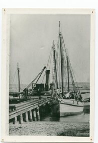 Orbost & District Historical Society
black and white photograph, before 1912
This photo shows the Storm Bird at the end of the jetty and the Wangrabelle in the foreground. Both ships were well known traders. the Wangrabelle became beached and wrecked in 1916 and the Storm Bird became obsolete when the railway from Bairnsdale to Orbost arrived in 1916. (ref. Story of Gippsland Shipping - J.C. Bull) At the start of the river trade goods were shipped from Marlo to Melbourne but when the railway reached Bairnsdale this became unprofitable and the ships plied only between Marlo and Cunninghame. Eventually river transport became economically unviable. The Wongrabelle is still buried in the sands of the entrance of the Snowy River (albeit where the entrance used to be). It took from April 11th 1912 to August 12th 1912 for the loss of the Wongrabelle to be complete, the final entry in the Orbost Shipping Co. records reads:- "The Wongrabelle is completely covered in sand." (ref River, Road, Railway Newsletter O.D.H.S.) This is a pictorial record of a time when the water highways were the only feasible transport mode in sending goods from Orbost and Marlo to Melbourne.A black / white photograph of a ship, sails down, anchored at the Marlo jetty.on back - "M. Gilbert, Wangrabelle at Marlo"storm-bird wangrabelle shipping transport- marlo -
 Orbost & District Historical Society
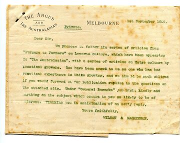
letter, September 1 1909
When early settlers began to arrive on the Snowy River somewhere in the 1880s, the land was mostly swamps and heavily timbered jungle on the river frontages. The swamps were drained bit by bit using hand tools. The frontages were cleared by axe and shovel and fire. Several kinds of crops were experimented with such as hops, hemp and maize. Maize grew particularly well and became the main crop of the district. (info. from October 2006 ODHS Newsletter) The Argus was a morning daily newspaper in Melbourne, Australia that was established in 1846 and closed in 1957. It was considered to be the general Australian newspaper of record for this period.Maize-growing has been an important agricultural industry in the Orbost district since early settlement. This item is associated with that history.A typed letter sent to a local maize farmer requesting information on maize growing. The letter has the "Argus" letter head. The name of the recipient is unknown.maize agriculture-orbost correspondence-argus -
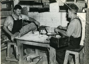 Vision Australia
Photograph - Image, Queensland Institute for the Blind matting, cane and mattress workshop, August 1952
Fives images of the workshop machinery used by the Queensland Industrial Institute for the Blind in the manufacture of various products. 1 - Pitched brooms being made by Stewart Jewell (left) and Jack Dollier (right). 2 - Unknown worker at a basket station making a cane basket, surrounded by finished examples. 3 - Snowy Willis oversees the operation of the machine that bores holes into brush heads. 4 - Unknown worker operating a coir matting machine. There were apparently 10 such machines in use at the time this image was taken. 5 - Snowy Willis checking the bobbins being filled from a giant spool. In the background are empty bobbins stacked against walls and filled bobbins on spool holders. 6 - Roy Anderson checks the wadding on a recently filled mattress, whilst in the background Ellen McDevitt uses a portable sewing table to sew the ends of a filled mattress.6 x B/W photographs of the workshop machinery used by the Queensland Industrial Institute for the BlindC2-657: 2, Brush shop - pitch set brooms being made by blind workers C2-664: Basket shop - some of the various types of baskets made C2-654: Snowy Willis. Brush shop - a semi automatic brush stock boring machine in operation. C2-666: Matting shop - one of the ten coir matting looms in use. 1960. C2-659: Matting shop - bobbin winder and bobbin bank. C2-655: 15. 2 col wide. Bed shop wadding a fibre mattress. Also showing special sewing machine and movable table used in sewing the mouths of filled mattresses.queensland industrial institute for the blind, stuart jewell, jack dollier, snowy willis, roy anderson, ellen mcdevitt -
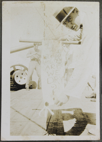 Mission to Seafarers Victoria
Photograph, Crossing the Line ceremony
Sailor is holding a sign reading: June 7, 1927, Lat 000, Long 171 W: Are we dry? indicating they are in the middle of the Pacific Ocean.duncan album, crossing the line -
Glenelg Shire Council Cultural Collection
Document - Bottle Labels, n.d
Set of 6 bottle labels, Cal Master low calorie dry ginger ale with artificial sweetener. Silver labels, blue and white printing.drink bottle label -
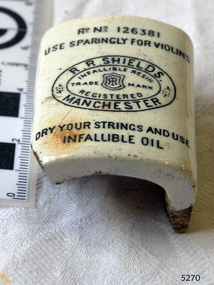 Flagstaff Hill Maritime Museum and Village
Ceramic
Piece of ceramic with Reg No 126381 Use sparingly for violins. R.R. Shields Manchester Infallible Resin Dry your strings and use infallible oil."flagstaff hill, warrnambool, shipwrecked-coast, flagstaff-hill, flagstaff-hill-maritime-museum, maritime-museum, shipwreck-coast, flagstaff-hill-maritime-village, violin -
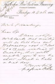 Bendigo Historical Society Inc.
Document - COHN BROTHERS COLLECTION: HANDWRITTEN LETTER DATED 1893
Letter dated 4th Oct 1893 from Magnus Cohn to Secretary. Paper also has a Water Mark, StJames Air-dried Vallum.bendigo, industry, cohn bros brewery