Showing 6759 items matching "timor street"
-
 Eltham District Historical Society Inc
Photograph, Looking southeast across Main Road to intersection with Cecil Street, Eltham, February 1968, Feb 1968
Shows street sign for Diamond Street on right with the railway crossing.In February 1968 an unknown person took a series of photos from the Eltham Hotel at Pitt Street heading north along Main Road through the shopping centre to just north of Elsa Court covering the length of the section of Main Road which was duplicated shortly thereafter. Shows the condition and environment of the streesscape of Main Road, Eltham immediately prior to the duplication between Pitt Street and Elsa Court through the shopping centre. Also shows a number of shops and businesses that operated at that time.Black and white photographduplication, eltham, main road, cecil street, diamond street -
 Eltham District Historical Society Inc
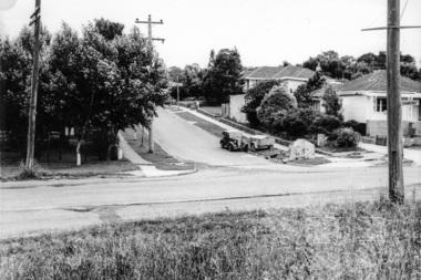
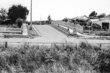
Photograph, Looking east across Main Road from just north of intersection with Diamond Street, Eltham, February 1968, Feb 1968
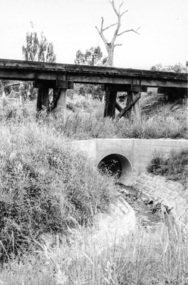
The watercourse passes under the road and railway at this point. Significant flash flooding occurred along this water course on Christmas Day 2011 causing significant damage to the railway line and road and flooding of Judge Book Village. In February 1968 an unknown person took a series of photos from the Eltham Hotel at Pitt Street heading north along Main Road through the shopping centre to just north of Elsa Court covering the length of the section of Main Road which was duplicated shortly thereafter. Shows the condition and environment of the streesscape of Main Road, Eltham immediately prior to the duplication between Pitt Street and Elsa Court through the shopping centre. Also shows a number of shops and businesses that operated at that time.Black and white photographduplication, eltham, main road, diamond street, bible street reserve, watercourse, drainage -
 Eltham District Historical Society Inc
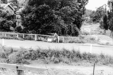
Photograph, Looking west from Main Road from just north of intersection with Diamond Street, Eltham, February 1968, Feb 1968
The watercourse passes under the road and railway at this point. Significant flash flooding occurred along this water course on Christmas Day 2011 causing significant damage to the railway line and road and flooding of Judge Book Village. The drain was swept away including the support pillars of the rail lines timber framework. Judge Book Village had some 40 units flooded before the water entered Diamond Creek. The water had flowed down and flooded Valonia Drive then Grove Street before flowing down the watercourse to Main RoadIn February 1968 an unknown person took a series of photos from the Eltham Hotel at Pitt Street heading north along Main Road through the shopping centre to just north of Elsa Court covering the length of the section of Main Road which was duplicated shortly thereafter. Shows the condition and environment of the streesscape of Main Road, Eltham immediately prior to the duplication between Pitt Street and Elsa Court through the shopping centre. Also shows a number of shops and businesses that operated at that time.Black and white photographduplication, eltham, main road, diamond street, watercourse, drainage, railway line -
 Eltham District Historical Society Inc
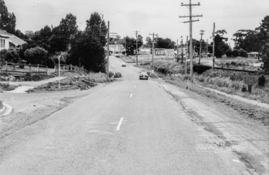
Photograph, Looking south along Main Road towards the shops form near the intersection with Elsa Court, Eltham, February 1968, Feb 1968
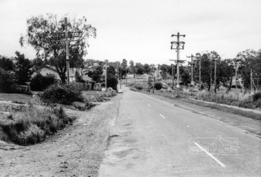
In February 1968 an unknown person took a series of photos from the Eltham Hotel at Pitt Street heading north along Main Road through the shopping centre to just north of Elsa Court covering the length of the section of Main Road which was duplicated shortly thereafter. Shows the condition and environment of the streesscape of Main Road, Eltham immediately prior to the duplication between Pitt Street and Elsa Court through the shopping centre. Also shows a number of shops and businesses that operated at that time.Black and white photographduplication, eltham, main road, railway line, elsa court -
 Eltham District Historical Society Inc
Photograph, Looking east across Main Road towards Elsa Court, Eltham, February 1968, Feb 1968
In February 1968 an unknown person took a series of photos from the Eltham Hotel at Pitt Street heading north along Main Road through the shopping centre to just north of Elsa Court covering the length of the section of Main Road which was duplicated shortly thereafter. Shows the condition and environment of the streesscape of Main Road, Eltham immediately prior to the duplication between Pitt Street and Elsa Court through the shopping centre. Also shows a number of shops and businesses that operated at that time.Black and white photographduplication, eltham, main road, elsa court -
 Eltham District Historical Society Inc
Photograph, Looking south along Main Road from the intersection with Elsa Court, Eltham, February 1968, Feb 1968
In February 1968 an unknown person took a series of photos from the Eltham Hotel at Pitt Street heading north along Main Road through the shopping centre to just north of Elsa Court covering the length of the section of Main Road which was duplicated shortly thereafter. Shows the condition and environment of the streesscape of Main Road, Eltham immediately prior to the duplication between Pitt Street and Elsa Court through the shopping centre. Also shows a number of shops and businesses that operated at that time.Black and white photographduplication, eltham, main road, elsa court, railway line -
 Eltham District Historical Society Inc
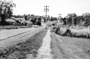
Photograph, Looking south along Main Road from just north of Elsa Court, Eltham, February 1968, Feb 1968
Shows where the future duplication of Main Road ends just north of Elsa Court.In February 1968 an unknown person took a series of photos from the Eltham Hotel at Pitt Street heading north along Main Road through the shopping centre to just north of Elsa Court covering the length of the section of Main Road which was duplicated shortly thereafter. Shows the condition and environment of the streesscape of Main Road, Eltham immediately prior to the duplication between Pitt Street and Elsa Court through the shopping centre. Also shows a number of shops and businesses that operated at that time.Black and white photographduplication, eltham, main road, elsa court, railway line -
 Eltham District Historical Society Inc
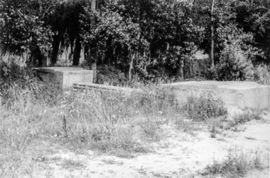
Photograph, Eltham, February 1968, Feb 1968
Location and significance not yet identified for this structure which was part of the series of 48 photos taken along Main Road, Eltham in February 1968In February 1968 an unknown person took a series of photos from the Eltham Hotel at Pitt Street heading north along Main Road through the shopping centre to just north of Elsa Court covering the length of the section of Main Road which was duplicated shortly thereafter. Shows the condition and environment of the streesscape of Main Road, Eltham immediately prior to the duplication between Pitt Street and Elsa Court through the shopping centre. Also shows a number of shops and businesses that operated at that time.Black and white photographduplication, eltham, main road -
 Eltham District Historical Society Inc
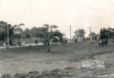
Photograph, Alistair Knox Park, Eltham, c.1970, 1970c
View from northwest corner showing survey pegs for trees and two ponds. Main Road has been duplicated. Bridge Street intersection showing the rock wall on the east side of the original Main Road (Maria Street). Burgoyne's Store and Eltham Uniting Church in distance at centre right and Our Lady Help of Christians at centre left.In February 1968 an unknown person took a series of photos from the Eltham Hotel at Pitt Street heading north along Main Road through the shopping centre to just north of Elsa Court covering the length of the section of Main Road which was duplicated shortly thereafter. Shows the condition and environment of the streesscape of Main Road, Eltham immediately prior to the duplication between Pitt Street and Elsa Court through the shopping centre. Also shows a number of shops and businesses that operated at that time.Black and white photographduplication, eltham, main road, bridge street, burgoyne's shop, eltham uniting church, our ladys church, maria street -
 Eltham District Historical Society Inc
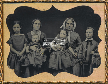
Photograph - Daguerreotype Photo Case, Members of the Hill family, early Eltham settlers, c.1860
Mrs Georgina Hill (wife of Henry), nee Reynolds (of Research, Vic.) in cap [possibly misidentified by donor - see note below] with Mrs Isaac Hill and her children (left to right) Amelia Hill, (born 1853) Mrs Isaac Hill with baby Isaac (born 1860, Eltham) on her lap. Mary Jane Hill (born 1857, Eltham) seated on Mrs Henry Hill's lap and Bob Hill. The Hill family were early settlers of the Eltham area. Daguerreotype photo enclosed in a leather bound clam shell box with felt lining and gold trim. Donated by Mrs Ivy Edna Hill, 4/1 Bridge Street, Eltham, 4 June 1966 and includes copy of her note identifying the people. Daguerreotypes were one of the first forms of early photographs. They initially appeared in Europe in 1839 and were produced in large numbers to the early 1850s but were superseded by more modern and flexible forms of technology by 1860. The photo was usually formed on a thin copper plate with light sensitve silver iodide. They have a mirror-like appearance and the image itself was mirrored. They were usually inserted into a case or frame made of wood bound in leather or velvet and cost about one guinea in Australia, the equivalent of a week's wages. With the advent of the gold-rush and growing population came an increase in numbers of photographers both studio and travelling. The daguerreotype process was protected by patents and could only result in a single image from which no copies could be made. With new technology involving wet colloidion glass plate negatives and albumen paper prints of which multiple copies could be produced at significantly reduced cost, the dauguerreotype quickly fell out of favour. An accompanying note with the photo written by Edna Hill of 4/1 Bridge Street Eltham dated 4 June 1966 states: "Dear Mr Watson, I think the enclosed old time photograph will be of interest to you. It would have been taken about 1860. The two ladies are the wives of the original pioneers of the Hill family. The one in the cap was the wife of Henry Hill, the other of Isaac Hill. The children are those of Mrs Isaac Hill, and grandchildren to Henry Hill. The little girl on the left is Amelia, the baby Isaac, the second girl is Mary Jane, and the boy on the right is Bob Hill. They grew up tobe Uncles and Aunts of my late husband. I greatly appreciated a letter received a few months ago per Cr Pelling, from the Shillinglaw Cottage Committee. Yours sincerely, Edna Hill" Victorian birth registrations show Mary Jane Hill was born 1857 in Eltham (9879 / 1857) and Isaac Hill at Eltham in 1860 (1972/1860) NOTE: Mrs Isaac Hill was Ellen Fitzsimons (1834-1863), mother to Henry Hill. Mrs Georgina Hill, wife of Henry cannot be the lady in the cap as she was not born till 1864. Georgina Reynolds (1864-1927) married Henry Hill (1862-1948) in 1884. This lady has significant wrinkling of the face, especially around her mouth. It is possible that she is the mother of Mrs Isaac Hill (Ellen Fitzsimons) who was Isabella Fitzsimons (nee Ferguson).Early pioneer settlers of ElthamAntique daguerreotypes in hinged gold frame, glass encased in a small clam-shell box lined with padded red felt and with catchamelia hill, bob hill, early settlers, eltham, hill family, isaac hill, mary jane hill, mrs henry hill, mrs isaac hill, daguerreotype, georgina hill (nee reynolds), research (vic.), sepp, shire of eltham pioneers photograph collection, women, ellen hill (nee fitzsimons), isabella fitzsimons (nee ferguson) -
 Eltham District Historical Society Inc
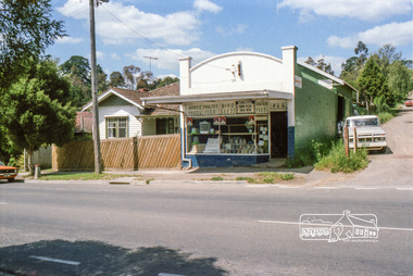
Photograph, Eltham Feed Store, cnr Main Road and York Street, c.1985, c.1985
General store and house built by C.R. Nicholl's in late 1925 at the same time J.N. Burgoyne built his store. Nicholl's sold the store and three allotments in York Street 1931. During the 1950s when the Moar family lived at No. 11 the grocery store was run by Cockcrofts. After Cockcrofts it was Davis and they turned it into a hardware store and timber yard at the side. [Note: dated based on negatives 01791 (20 Jan 1986) as service station and pricing for fuel very similar period; possibly late 1985]Reflects on the changing nature of the local street-scape and housesRoll of 35mm colour negative film, 7 stripsKodak CL 200 5093eltham, york street, main road, eltham feed store, shops, 1985, general store -
 Eltham District Historical Society Inc
Photograph, Liz Pidgeon, Heritage Excursion; The 1901 Eltham Railway Walk, 3 May 2014, 3 May 2014
Newsletter No. 216, May 2014 May Excursion – The 1901 Eltham Railway Walk The railway from Heidelberg to Eltham was opened in 1902. Over the previous year railway construction cut a curving swathe through Josiah Holloway’s 1851 Little Eltham subdivision. The survey plans for the railway show the owners and occupiers of land within Little Eltham affected by the railway alignment and for some distance each side. The plans show houses and other buildings but development at that time was rather sparse. Copies of these plans from the State Library of Victoria collection have been provided to the Society by Alan Sheehan. For our walk on 3rd May we intend to follow the railway from the Eltham Station to Ryans Road, which was the boundary of the adjoining Montmorency Farm. The return will be by way of nearby streets. Along the way we will discuss the details shown on the railway plans as well as more recent railway documents and photographs. At the conclusion and if time permits we can inspect the historical display at the Eltham Station. The walk is about 3 km in length and will take about 2.5 hours. It will start at 2 pm at the Eltham Railway Station car park (east/Main Road side) (Melway Ref. 21 J5).Born Digitalheritage excursion, activities, eltham district historical society, eltham railway station, eltham library, trestle bridge -
 Eltham District Historical Society Inc
Photograph, Liz Pidgeon, Heritage Excursion; The 1901 Eltham Railway Walk, 3 May 2014, 3 May 2014
EDHS Member Doug Orford stands by a yarn bombing installation. ewsletter No. 216, May 2014 May Excursion – The 1901 Eltham Railway Walk The railway from Heidelberg to Eltham was opened in 1902. Over the previous year railway construction cut a curving swathe through Josiah Holloway’s 1851 Little Eltham subdivision. The survey plans for the railway show the owners and occupiers of land within Little Eltham affected by the railway alignment and for some distance each side. The plans show houses and other buildings but development at that time was rather sparse. Copies of these plans from the State Library of Victoria collection have been provided to the Society by Alan Sheehan. For our walk on 3rd May we intend to follow the railway from the Eltham Station to Ryans Road, which was the boundary of the adjoining Montmorency Farm. The return will be by way of nearby streets. Along the way we will discuss the details shown on the railway plans as well as more recent railway documents and photographs. At the conclusion and if time permits we can inspect the historical display at the Eltham Station. The walk is about 3 km in length and will take about 2.5 hours. It will start at 2 pm at the Eltham Railway Station car park (east/Main Road side) (Melway Ref. 21 J5).Born Digitalheritage excursion, activities, eltham district historical society, eltham railway station, eltham library, trestle bridge, yarn bombing, doug orford -
 Eltham District Historical Society Inc
Photograph, Liz Pidgeon, Heritage Excursion; The 1901 Eltham Railway Walk, 3 May 2014, 3 May 2014
Newsletter No. 216, May 2014 May Excursion – The 1901 Eltham Railway Walk The railway from Heidelberg to Eltham was opened in 1902. Over the previous year railway construction cut a curving swathe through Josiah Holloway’s 1851 Little Eltham subdivision. The survey plans for the railway show the owners and occupiers of land within Little Eltham affected by the railway alignment and for some distance each side. The plans show houses and other buildings but development at that time was rather sparse. Copies of these plans from the State Library of Victoria collection have been provided to the Society by Alan Sheehan. For our walk on 3rd May we intend to follow the railway from the Eltham Station to Ryans Road, which was the boundary of the adjoining Montmorency Farm. The return will be by way of nearby streets. Along the way we will discuss the details shown on the railway plans as well as more recent railway documents and photographs. At the conclusion and if time permits we can inspect the historical display at the Eltham Station. The walk is about 3 km in length and will take about 2.5 hours. It will start at 2 pm at the Eltham Railway Station car park (east/Main Road side) (Melway Ref. 21 J5).Born Digitalheritage excursion, activities, eltham district historical society, eltham railway station, eltham library, trestle bridge -
 Eltham District Historical Society Inc
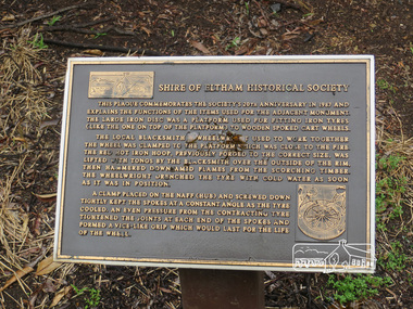
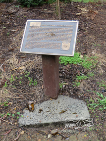
Photograph, Liz Pidgeon, Monument containing a time capsule in celebration of Victoria's 150th Anniversary and marking the location of the original centre of Eltham township, 21 June 2017, 21 June 2017
A walk around Little Eltham, 21 June 2017 Newsletter No. 175 July 2007 FORTY YEARS IN HISTORY The Society has been involved with a number of one off historical projects that have lasting outcomes. Perhaps the most significant is the monument and time capsule installed at the Eltham Community Centre site at the comer of Pitt Street and Main Road to commemorate Victoria's 150th anniversary. The monument based on a blacksmith's tyring plate was designed by artist Joh Ebeli. Beneath it is a time capsule containing items from 1985 and donated by Graham Beyer. It is to be opened in 2035.Born Digitalmain road, time capsule, monuments -
 Eltham District Historical Society Inc
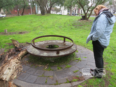
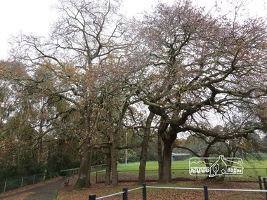
Photograph, Oak Trees and Eltham Rugby Football Club oval, Diamond Creek Trail, 21 June 2017, 21 June 2017
A walk around Little Eltham, 21 June 2017. Eltham’s first industrial area at the end of present day Pitt Street near the Diamond Creek. Just upstream a bit, near these oak trees was the flour mill. The most significant owner of that was Henry Dendy. Better known for founding Brighton but he lived in Eltham longer than he lived in Brighton, during the 1860s. There was also the brewery and slightly downsteam from here was the tannery. The brewery needed fresh clean water so it was upstream from the tannery. The Oak trees were most likely planted during Henry Dendy's time. (Source: Local historian commentary, Eltham Hidden Creek heritage excursion 7 March 2020) Born Digitaleltham community centre, diamond creek trail, eltham rugby football club, oak trees, henry dendy -
 Eltham District Historical Society Inc
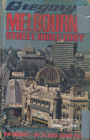
Book, Gregory's Melbourne Street Directory of Melbourne and suburbs and metropolitan road guide (8th edition) extends to Laverton, Deer Park, Epping, Diamond Creek, Lilydale, Olinda, Belgrave, Doveton and Mornington, 1973
This is the 8th edition of Gregory's Melbourne Street Directory, fully revised and up-to-date for this edition published December 1973. It is a comprehensive guide to the streets and localities of Melbourne and suburbs at that time. The colour maps are arranged in double-page spreads. Names of streets and suburbs are arranged alphabetically in the index to streets.Hard copy with plastic cover. 382 p. streets, melbourne - maps, roads