Showing 12622 items matching " development"
-
 Moorabbin Air Museum
Manual (Item) - Aircraft Instrument Catalog - Eighth Annual Issue
Description: 30 pages. Published by Aircraft Instrument & Development Inc. Published with materials from 1975-1976. AID 001 Level of Importance: World. -
Moorabbin Air Museum
Manual (Item) - Aerotep Associates Aircraft Parts
Description: 31 pages. Published by Aircraft Instrument & Development Inc. Published with materials from 1975-1976. AID 002 Level of Importance: World. -
 Sunbury Family History and Heritage Society Inc.
Photograph, 15th August 1995
The house was the former station master's residence. When the photograph was taken it served as a restaurant. In the late 1990s it was demolished to make way for larger commercial development.The former stationmaster's residence was one of the important buildings in Sunbury.A coloured photograph of a cream weatherboard house with light green trims surrounded by a garden. Four cars are parked outside the house.sunbury railway station, stationmaster's residence, brook street -
Canterbury History Group
Document - The foundation of our city, Renwick, Reg, c1973
A paper read to Camberwell Historical Society by Mr Reg. Renwick describing the part played by the Boroondara Road Board in the development of Camberwell and surrounding areas.4 foolscap pagescanterbury, camberwell, kew, hawthorn, boroondara road board, roads, tollhouses, palmer> sir james, affleck> john, box> henry, brooks> thomas, lavis> george, lynch> mkichael, pettett> william henry, stobie> david, wade> william henry, walsh> henry sellars, withers> john -
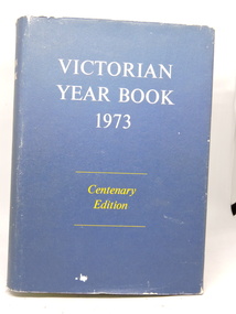 Kilmore Historical Society
Victorian Year Book 1973, Victorian Year Book 1973, Centenary Edition, No. 87, 1973
Centenary Edition traces the major environmental, social, economic, and technological factors which have affected the State of Victoria. Gives an historical perspective of these developments.Hardcover with dust jacket worn at edges. Illustrated, photos, charts. Excellent condition. 1261 pp.'D $6.00" front flyleaf.year book 1973, victoria -
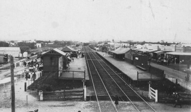 City of Kingston
Photograph - Digital image, Black and white, c. 1910
Black and white image of Chelsea Railway Station showing the impact of the railways on the development of the area. Shops and shoppers can be seen behind the station buildings.The extension of the railway line from Mordialloc to Frankston influenced the development of the villages along the train line. Shops and community buildings were built in proximity to the station, along with the subdivision of land for houses. Black and white image of Chelsea Railway Station showing platforms and local shopschelsea, railway station, railway, shopping strip, public transport -
Port Melbourne Historical & Preservation Society
Photograph - Fisherman's Bend: an old time settlement near Melbourne', Weekly Times, 1906
Copied during development of Fisher Folk of Fishermens Bend. Johann Meier was the great grandfather of the author of the book, Allan Meiers. The 'typical cottage' was Johann's.B&W photo of a page of the Weekly Times 27 October 1906 'Fishermen's Bend: an old time settlement near Melbourne', with photos of 'portion of the settlement which will be demolished to make room for reclamation', 'a typical cottage on The Bend', John Myers (Johann Meiers) a veteran fisherman'', and çottages fronting the beach'ballast ground, the bend, fishermans bend, domestic life, industry - fishing, johann meiers, john myer -
Moorabbin Air Museum
Book - Recounting training scheme development as well various personal stories, AIRCREW UNLIMITED The Commonwealth Air Training Plan during World War 2, John Golley, AIRCREW UNLIMITED The Commonwealth Air Training Plan during World War 2, 1993
Recounting training scheme development as well various personal stories, AIRCREW UNLIMITED The Commonwealth Air Training Plan during World War 2Cover jacket showing black outline drawing of pilots scrambling to aircraft, Tiger Moth in background, Harvard passing over, dark brown / blue background, white/yellow writing.non-fictionRecounting training scheme development as well various personal stories, AIRCREW UNLIMITED The Commonwealth Air Training Plan during World War 2 -
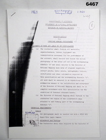 Bendigo Military Museum
Administrative record - Division of National Mapping - Specification for Vertical Aerial Photography, Division of National Mapping, 1963
Commonwealth of Australia, Department of Defence of National Development, Division of National Mapping Specification. This is a Specification for Aerial Photography acquisition and is written for civilian contract work.8 x A4 poor photocopies of typed pagesroyal australian survey corps, rasvy, fortuna, army survey regiment, army svy regt, asr -
Federation University Historical Collection
Equipment - Camera, Thornton-Pickard, Thornton Pickard Triple Imperial Extension Camera, c1901
Thornton-Pickard was a famous British camera manufacturer established in 1888. The company was based in Altrincham, near Manchester, and was an early pioneer in the development of the camera industry.Thornton Pickard Triple Imperial Extension half plate camera nos 529946 and 529947. The camera has leather bellows, and was originally mounted on a tripod.camera, extension camera, photographic equipment -
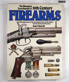 Bendigo Military Museum
Book - REFERENCE, FIREARMS, Major F. MYATT MC, "THE ILLUSTRATED ENCYCLOPEDIA OF 19TH CENTURY FIREARMS", 1989
Information from the Title page. "The Illustrated/ Encyclopedia of 19th Century/ FIREARMS/ An illustrated history of the development of the world's military/ firearms during the 19th century."Hard cover book with dust cover. Hardcover - cardboard, dark brown colour buckram with gold colour print on spine. Dust cover - paper, black and blue colour print on front, spine and back. Illustrated front to back - colour photographs of various firearms on off white background. 216 pages - cut, plain, white colour paper. Illustrated black and white and colour photographs, posters and paintings. Colour and line drawings. End papers - illustrated in colour photograph of firearms equipment. Front handwritten information. Shop adhesive label on back of dust cover. Handwritten information - grey lead pencil "1979 $75-". Shop adhesive label - red and black print "Was 45.00/ MARY MARTIN'S/ BARGAIN PRICE/ $$ 19.99".publications, books, refernce guide, history, firearms -
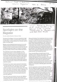 Whitehorse Historical Society Inc.
Article - National Trust of Australia (Victoria) Magazine, National Trust of Australia, Boongarry Avenue, Blackburn, Autumn 2023???
A photocopy of an article from the Victorian National Trust magazine pertaining to the inclusion of Boongarry Avenue for landscape classification within the Blackburn Lake and Bell Bird Streets, Blackburn.A photocopy of an article from the Victorian National Trust magazine pertaining to the inclusion of Boongarry Avenue for landscape classification within the Blackburn Lake and Bell Bird Streets, Blackburn.non-fictionA photocopy of an article from the Victorian National Trust magazine pertaining to the inclusion of Boongarry Avenue for landscape classification within the Blackburn Lake and Bell Bird Streets, Blackburn.boongarry avenue blackburn, blackburn lake, national trust of australia victoria -
 Melbourne Tram Museum
Document - Report, Melbourne & Metropolitan Tramways Board (MMTB), "Melbourne and Metropolitan Tramways Board General Scheme", late 1950's
Report - 33 pages, duplicated, stapled within a grey "Roneo Numeralpha System" folder, titled "Melbourne and Metropolitan Tramways Board General Scheme" dated 30/11/1922 giving details of the Board's proposals for tramways to serve the Melbourne metropolis, gives details of the existing system, population, proposals for extensions, special services with a sheet on statistics and an appendix listing five plans and three graphs - not with this document. See Reg Item 2088 for another copy and 2089 for Plan A referred to.Stamped on report and cover "Chief Engineer"trams, tramways, mmtb, general scheme, tramways, development, parliament, brighton, railways, finances, construction -
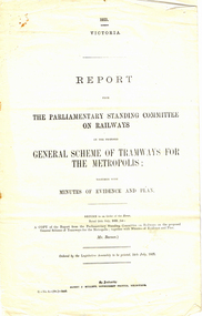 Melbourne Tram Museum
Map, Melbourne & Metropolitan Tramways Board (MMTB), Report - "Melbourne and Metropolitan Tramways Board General Scheme", May. 1923
.1 - Printed document - 1923 - Report - 8 pages - The Parliamentary Standing Committee on Railways - General Scheme for Tramways for Metropolis - printed 24/7/1923. Gives details of the committee, the committee report, comments on the Board's financial position, the debate between tramways or railways, recommendations and views of the Railways Commissioners. .2 - Associated map - Map - drawing with a line back, titled "Melbourne and Metropolitan Tramways Board Proposals for General Scheme". Shows the proposed tram lines submitted to Parliament for the report into the General Scheme. Printed by Sands & McDougall Pty Ltd. Signed by J. P Strickland dated 27-8-1923. .3 - as for .1, but in good condition - added 27-3-2018 from donation of Norm Cross.trams, tramways, mmtb, general scheme, tramways, development, parliament, brighton, railways, finances, map -
 Kew Historical Society Inc
Plan, Melbourne & Metropolitan Board of Works : Borough of Kew : Detail Plan No.1576, 1904
The Melbourne and Metropolitan Board of Works (MMBW) plans were produced from the 1890s to the 1950s. They were crucial to the design and development of Melbourne's sewerage and drainage system. The plans, at a scale of 40 feet to 1 inch (1:480), provide a detailed historical record of Melbourne streetscapes and environmental features. Each plan covers one or two street blocks (roughly six streets), showing details of buildings, including garden layouts and ownership boundaries, and features such as laneways, drains, bridges, parks, municipal boundaries and other prominent landmarks as they existed at the time each plan was produced. (Source: State Library of Victoria)This plan forms part of a large group of MMBW plans and maps that was donated to the Society by the Mr Poulter, City Engineer of the City of Kew in 1989. Within this collection, thirty-five hand-coloured plans, backed with linen, are of statewide significance as they include annotations that provide details of construction materials used in buildings in the first decade of the 20th century as well as additional information about land ownership and usage. The copies in the Public Record Office Victoria and the State Library of Victoria are monochrome versions which do not denote building materials so that the maps in this collection are invaluable and unique tools for researchers and heritage consultants. A number of the plans are not held in the collection of the State Library of Victoria so they have the additional attribute of rarity.Original survey plan, issued by the MMBW to a contractor with responsibility for constructing sewers in the area identified on the plan within the Borough of Kew. The plan was at some stage hand-coloured, possibly by the contractor, but more likely by officers working in the Engineering Department of the Borough and later Town, then City of Kew. The hand-coloured sections of buildings on the plan were used to denote masonry or brick constructions (pink), weatherboard constructions (yellow), and public buildings (grey). Development in the 20th century has irreparably altered that part of Kew represented in this plan. In the block bounded by Cotham Road, Charles Street, Wellington Street and Gellibrand; just one house standing in 1903 remains. This block included two of the most historic houses in Kew: ‘Ordsall’ (later ‘Southesk’) and ‘Madford’ (previously ‘Elm Lodge’). Ordsall was the home of the second chairman of Kew, John Halfey. It contained some of the most significant interior murals in Kew, created for Halfey by artists working for Cullen & Co. It was demolished in 1960 to make way for the Kew Civic Centre. Elm Lodge had been built for William Siddeley in ca. 1864. Arthur Septimus King purchased it in 1874. The lower paddocks of Madford were sold in 1905 by his wife to the Borough of Kew and, after landscaping by George and Thomas Pockett, opened as the Alexandra Gardens in 1908. Elm Lodge/Madford was in 1922 to become St. Anthony’s Home for Little Children before its subsequent demolition in the 1980s.melbourne and metropolitan board of works, detail plans, maps - borough of kew, mmbw 1576, cartography -
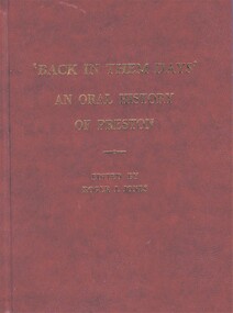 Greensborough Historical Society
Book, Roger J. Jones, 'Back in them days': an oral history of Preston, 1994
119 p. , black and white illustrations; with colour photograph of book launch, compliments slip and article on Junction Hotel Preston pasted inpreston victoria, city of preston, preston city library, oral history, social conditions, working conditions -
 Greensborough Historical Society
Planning Document, Banyule City Council, Site plan of Greensborough 1997, 28/07/1997
Site plans for the area bounded by Flintoff Street; Grimshaw Street; Main Street and Para Road Greensborough. these plans show the area before the development of Watermarc.This plan shows central Greensborough before the Watermarc developmentSet of 8 site plansgreensborough, greensborough swimming pool -
 Kew Historical Society Inc
Plan, Melbourne & Metropolitan Board of Works : Contour Plan of Melbourne & Suburbs : Melbourne Sewage, 1894
The Melbourne and Metropolitan Board of Works (MMBW) plans were produced from the 1890s to the 1950s. They were crucial to the design and development of Melbourne's sewerage and drainage system. This plan forms part of a large group of MMBW plans and maps that was donated to the Society by the Mr Poulter, City Engineer of the City of Kew in 1989. Within this collection, thirty-five hand-coloured plans, backed with linen, are of statewide significance as they include annotations that provide details of construction materials used in buildings in the first decade of the 20th century as well as additional information about land ownership and usage. The copies in the Public Record Office Victoria and the State Library of Victoria are monochrome versions which do not denote building materials so that the maps in this collection are invaluable and unique tools for researchers and heritage consultants. A number of the plans are not held in the collection of the State Library of Victoria so they have the additional attribute of rarity.Digital copy of an original MMBW plan. This contour plan shows the area identified by the MMBW for purposes of drainage and sewerage in 1894. The suburbs represented extend from Williamstown in the west to Bulleen in the east, and from Preston in the north, south to Sandringham. Suburbs are outlined in coloured ink. Red lines indicate main and branch sewers in existence at the beginning of 1894 in central and inner Melbourne. These extended as far as Williamstown and Brighton, but not yet as far as Kew, where sewering did not commence until 1901. Contour lines show the topography, which was important for indicating the fall of the land for the laying of sewers and drainage channels. Kew appears to be fairly undeveloped at this date except for railway lines and stations (the Kew and Outer Circle lines), main roads, the Kew Lunatic Asylum Reserve and Studley Park. However, the contour plan does not accurately represent the density of settlement, nor the large number of houses, which were being built in Kew and other suburbs from the 1850s to the land boom of the late 1880’s and early 1890’s. This plan is part of a large and historically significant group of MMBW plans and maps that was donated to the Society by the Mr Poulter, City Engineer of the City of Kew in 1989.mmbw contour plan of melbourne and suburbs, melbourne and metropolitan board of works, melbourne sewage, cartography -
University of Melbourne, Burnley Campus Archives
Document, Burnley Horticultural College Feasibility Study 1980 Volume 1: Design Specification
Prepared for Department of Agriculture Division of Agricultural Education by Public Works Department, Victoria J. T. Green, Acting Chief Architect, Research and Development GroupIncludes 9-page Inventory prepared by W.K. Pooley, 16/4/1982burnley horticultural college -
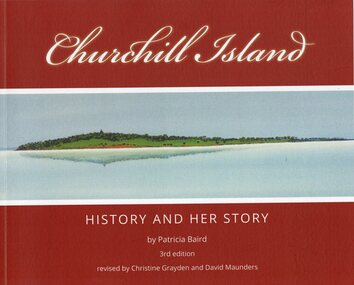 Phillip Island and District Historical Society Inc.
Book, Churchill Island : history and her story, Original 2001 - 3rd Edition 2021
Churchill Island - Lieut. James Grant visited 21 March - 9 April 1801 and planted seeds. Story of the development of the Island and people who lived on it.Churchill Island History and Her Story by Patricia Baird, 3rd Edition. Revised by Christine Grayden and David MaundersAs Abovechurchill island, patricia baird, christine grayden, david maunders, george bass, james grant -
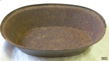 Flagstaff Hill Maritime Museum and Village
Domestic object - Dish
The development of bronze and iron metalworking skills allowed for cookware made from metal to be manufactured, although adoption of the new cookware was slow due to the much higher cost. After the development of metal cookware there was little new development in cookware, with the standard medieval kitchen utilising a cauldron and a shallow earthenware pan for most cooking tasks, with a spit employed for roasting. By the 17th century, it was common for a Western kitchen to contain a number of skillets, baking pans, a kettle and several pots, along with a variety of pot hooks and trivets. Brass or copper vessels were common in Asia and Europe, whilst iron pots were common in the American colonies. Improvements in metallurgy during the 19th and 20th centuries allowed for pots and pans from metals such as steel, stainless steel and aluminium to be economically produced. https://en.wikipedia.org/wiki/Cookware_and_bakewareThis item is significant as an example of an item in common use in the kitchen in the second half of the 19th Century, and thereafter.Metal oval cake/pie dish. Significant rust all over..None.flagstaff hill, warrnambool, shipwrecked-coast, flagstaff-hill, flagstaff-hill-maritime-museum, maritime-museum, shipwreck-coast, flagstaff-hill-maritime-village, cookware, bakeware, kitchenware -
Broadmeadows Historical Society & Museum
Photograph - Aerial Photograph
Craigieburn is a rapidly growing suburb located approximately 25 km north of Melbourne’s CBD. Historically, it was a rural area with agricultural roots, but since the late 20th century, it has undergone significant urban development. The transformation accelerated in the 1990s and 2000s, with large-scale residential subdivisions, infrastructure projects, and commercial developments reshaping the landscape. Key historical milestones include: Early Settlement: Originally inhabited by the Wurundjeri people of the Kulin Nation. European Settlement: Began in the mid-1800s, primarily for farming and grazing. Urban Expansion: Post-1970s, Craigieburn saw increasing suburban development, especially after the extension of rail and road infrastructure. Recent Growth: From the 2000s onward, Craigieburn became one of Melbourne’s fastest-growing suburbs, with new estates, schools, and shopping centres.This large colour aerial photograph of Craigieburn holds significant value as a visual record of the suburb’s transformation from a semi-rural landscape to a dynamic urban centre in Melbourne’s northern growth corridor. Captured during a period of rapid development, the image documents the spatial evolution of Craigieburn, including residential expansion, infrastructure projects, and the integration of green spaces and commercial zones. The photograph is historically significant as it reflects the broader patterns of post-2000 suburban growth in Victoria, driven by population pressures, housing demand, and strategic planning initiatives. It provides insight into land use changes, transport connectivity (notably the Hume Highway and Craigieburn railway line), and the emergence of community hubs such as Craigieburn Central. From a cultural heritage perspective, the image contributes to understanding the lived environment of diverse communities who have settled in Craigieburn, including its role in accommodating Melbourne’s multicultural population. It also serves as a reference point for future urban planning, environmental monitoring, and historical comparison. The photograph is an important archival asset for researchers, planners, and local historians, offering a detailed snapshot of a pivotal moment in Craigieburn’s development trajectory.Colour aerial photograph of Craigieburnaerial photograph, craigieburn -
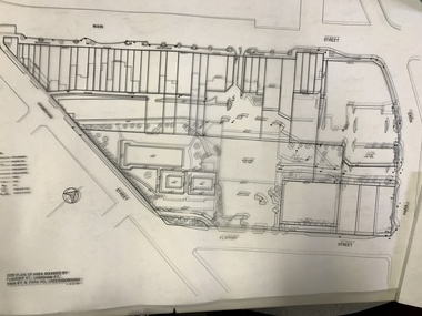
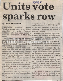 Eltham District Historical Society Inc
Document - Property Binder, 1151 Main Road, Eltham
Newspaper article: Units vote sparks row, Diamond Valley News, 8 April 1998, Nillumbik Council meeting discussed application for 7 double-storey attached units development at block from 1151 Main Road to Railway Road. Newspaper article: Units go-ahead as decision reversed, Diamond Valley News, 29 April 1998, Nillumbik Council discussed proposed developments at 1151 Main Road and 30 Swan Street. main road, eltham, property, houses, natalie woodley, robert marshall, marg jennings, john graves, lex de man, 30 swan street eltham, railway road eltham -
 Eltham District Historical Society Inc
Photograph, Kerb and channeling works, Beard Street and Main Road, Eltham, 3 Sep 1981
Roll of film taken by Eltham Shire Council officers of roads and houses in the Eltham East area, 3 September 1981 prior to construction of new water main; including views of existing damage to footpaths and gutters and general views of Beard Street. These images provide a perspective of housing estate developments and changes in housing styles and road development which began sweeping in from the mid 1970s with increasing urbanisation of what was once more outlying suburbs and regions.35mm colour positive transparency (1 of 28) Mount - Kodak Kodachrome Cardbeard street, eltham, footpaths and gutters, infrastructure, roads, main road -
 Eltham District Historical Society Inc
Photograph, Beard Street, Eltham, 3 Sep 1981
Roll of film taken by Eltham Shire Council officers of roads and houses in the Eltham East area, 3 September 1981 prior to construction of new water main; including views of existing damage to footpaths and gutters and general views of Beard Street. These images provide a perspective of housing estate developments and changes in housing styles and road development which began sweeping in from the mid 1970s with increasing urbanisation of what was once more outlying suburbs and regions.35mm colour positive transparency (1 of 28) Mount - Kodak Kodachrome Cardbeard street, eltham, infrastructure, roads, horse, park road -
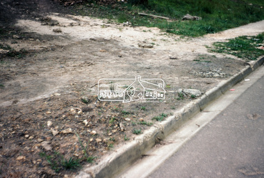
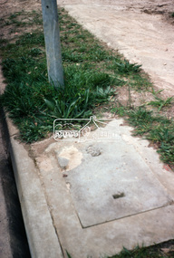
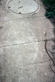
 Eltham District Historical Society Inc
Photograph, Foothpath and kerb damage, Bainbridge Drive, Eltham, 3 Sep 1981
Roll of film taken by Eltham Shire Council officers of roads and houses in the Eltham East area, 3 September 1981 prior to construction of new water main; including views of existing damage to footpaths and gutters and general views of Beard Street. These images provide a perspective of housing estate developments and changes in housing styles and road development which began sweeping in from the mid 1970s with increasing urbanisation of what was once more outlying suburbs and regions.35mm colour positive transparency (1 of 28) Mount - Kodak Kodachrome Cardeltham, infrastructure, roads, bainbridge drive, footpaths and gutters -
 Eltham District Historical Society Inc
Photograph, Foothpath and kerb damage, Bainbridge Drive, Eltham, 3 Sep 1981
Roll of film taken by Eltham Shire Council officers of roads and houses in the Eltham East area, 3 September 1981 prior to construction of new water main; including views of existing damage to footpaths and gutters and general views of Beard Street. These images provide a perspective of housing estate developments and changes in housing styles and road development which began sweeping in from the mid 1970s with increasing urbanisation of what was once more outlying suburbs and regions.35mm colour positive transparency (1 of 28) Mount - Kodak Kodachrome Cardeltham, infrastructure, roads, bainbridge drive, footpaths and gutters