Showing 123953 items
matching main-road
-
 Ballarat Tramway Museum
Sign - Staff Tickets, NSW Department of Road Transport and tramways, Sydney tramways staff tickets, 1930's-1950's
45 No. Dept. of Road Transport and tramway staff tickets used in the 1940's to 1960's for safeworking on single lines of Maitland, Newcastle and Sydney tram lines, see attached listing for full details, descriptions etc. Printed on flimsy paper. Some of the tickets show the personal name of the Government printer. This would enable time of printing to be better determined. (48 tickets in image). Image of list added 29/9/2013 - see related documents for details.trams, tramways, nsw, sydney, maitland, newcastle, safeworking, staff tickets -
 Ringwood and District Historical Society
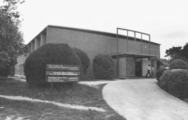
Photograph, Our Lady of Perpetual Succour - Bedford Road, Ringwood - 1973, 1973
Our Lady of Perpetual Succour in Bedford Road in 1973Typed below photograph, "Our Lady of Perpetual Succour - Bedford Road. 30.9.73" Black and white photograph of brick church with sign outside. -
 Whitehorse Historical Society Inc.
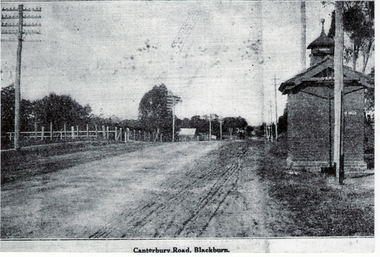
Photograph, Canterbury Road, Blackburn
Canterbury Road was previously known as Delaney's RoadBlack and white photograph of Canterbury Road, Blackburn before it was sealedcanterbury road, blackburn, roads and streets -
 Melton City Libraries
Photograph, Ferris Road Landscape, Unknown
Barrie House on Ferris Road was located on the west side south of Highway. Weather board house was moved from Harkness Rd in 1941 and was moved to Bulmans Road near Porteous Road 1988/90 The site was near the entrance to the Harness Racing Complex.Black and white photos of the Ferris Road landscapeagriculture -
 Lakes Entrance Historical Society
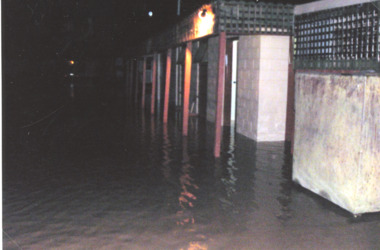
Photograph - Floods 1998 Lakes Entrance Victoria, Main Caravan Park, 2007 c
Colour photograph taken outside flooded buildings at Main Caravan Park Lakes Entrance Victoria. Also another colour photograph showing flooding inside toilet block at Main Caravan Parkfloods -
 Ballarat Heritage Services
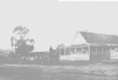
Photograph, Bellinzona House, 1900, 1900
Battista Borsa was from Bellinzona in Ticino, Switzerland. He named his house on the corner of Main road and Seventh St in Hepburn Springs "Bellinzona". His daughters ran the house as a guest house in 1900. This house was burnt down in the 1906 Bushfire. it was rebuilt in Edwardian tradition, and was again burnt down and rebuilt on a much larger footprint. A weatherboard house in the Main Road of Hepburn Springs, run by the Misses Borsa. borsa, bellinzona, boarding house, hepburn springs -
 Whitehorse Historical Society Inc.
Newspaper - Article, 39 Blackburn Road, Blackburn, 1/03/1992
Three newspaper advertisements for auction of 39 Blackburn Road, Blackburn. Solid brick Victorian residence, c1888.blackburn road, blackburn. -
 Whitehorse Historical Society Inc.
Photograph, 58 Dunlavin Road, Nunawading, 1/06/1997 12:00:00 AM
Coloured photo of 58 Dunlavin Road,Nunawading. (Dwelling has since been demolished and replaced with units.)dunlavin road, nunawading. no. 58. -
 Kew Historical Society Inc
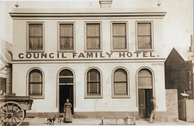
Photograph - Photograph [copy], Council Family Hotel, Cotham Road, circa 1888, c.1888
The Council Family Hotel was the fifth of the eight hotels to be licensed in Kew during the 19th Century. They were licensed in the following date order: The Woodman Inn (1854), The Harp of Erin (1854), O’Shaughnessy’s Kew Hotel (1855), the Prospect Hill Hotel (1858), the Council Family Hotel (1861), the Princess Hotel (1864), the Clifton Hotel (1868) and the Greyhound Hotel (1873).Rare photograph of a landmark Kew hotelExterior - Council Family Hotel in Cotham Road, Kew (Vic) with Mrs Ryan, wife of the licensee at frontMrs Ryanhotels - kew, council family hotel - kew (vic), licenees - ryan family -
 Tarnagulla History Archive
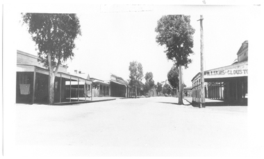
Photograph of Commercial Road, Tarnagulla, Commercial Road, Tarnagulla, c. 1968
Murray Comrie Collection. Burstall Hall appears to still be standing in this image.Monochrome photograph depicting a view down Commercial Road, Tarnagulla. WIlliams and Clouston's store visible at right.tarnagulla, commerce, commercial road, main street, clouston's, williams -
 Tarnagulla History Archive
Photograph: Commercial Road, Tarnagulla, Commercial Road, Tarnagulla, c.late 1960s
Murray Comrie Collection. This photograph is an original print.Monochrome photograph depicting view down Commercial Road, Tarnagulla. Circa 1960s vehicle parked at curb.tarnagulla, commercial road, buildings -
 Hawthorn Historical Society
Drawing - Property Illustration, 1-4/12 Burwood Road, Hawthorn
'After training as a Cartographic Draftsman within the mining industry, I worked as a property illustrator for real estate firms in the eastern suburbs of Melbourne for 23 years from 1983. I initially photographed houses with a Polaroid camera and made a 'thumbnail' sketch while there. The photos were used to scale off a sketch in pencil and then that sketch was overlaid with drafting film and the 'pen and ink' completed. The pens I used were the Rotring ‘Rapidigraph’ drafting pens. The ink was also made by Rotring (German).The film was ‘Rapidraw’, polyester drafting film, double matte. It takes a very fine line and doesn’t bleed. As well as house sketches, there were often floor plans and site plans ordered. Aerial sketches were ordered when the property needed an overall view.' (Margaret Picken, 2020)This property illustration is one of a series created by Margaret Picken for a range of real estate agents in Melbourne between c. 1983 and c. 2006. Each work is signed and dated by the artist.Gift of Margaret Picken, 2020Pen and ink property illustration on drafting film of 1-4/12 Burwood Road, Hawthorn by Margaret Picken.1-4/18 Burwood Road, Hawthorn, Marg Picken '95. Woodards - Haw.artist - margaret picken 1950- -
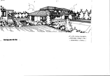 Hawthorn Historical Society
Drawing - Property Illustration, 17 & 17A Clifton Road, Hawthorn East
'After training as a Cartographic Draftsman within the mining industry, I worked as a property illustrator for real estate firms in the eastern suburbs of Melbourne for 23 years from 1983. I initially photographed houses with a Polaroid camera and made a 'thumbnail' sketch while there. The photos were used to scale off a sketch in pencil and then that sketch was overlaid with drafting film and the 'pen and ink' completed. The pens I used were the Rotring ‘Rapidigraph’ drafting pens. The ink was also made by Rotring (German).The film was ‘Rapidraw’, polyester drafting film, double matte. It takes a very fine line and doesn’t bleed. As well as house sketches, there were often floor plans and site plans ordered. Aerial sketches were ordered when the property needed an overall view.' (Margaret Picken, 2020)This property illustration is one of a series created by Margaret Picken for a range of real estate agents in Melbourne between c. 1983 and c. 2006. Each work is signed and dated by the artist.Gift of Margaret Picken, 2020Pen and ink property illustration on drafting film of 17 & 17A Clifton Road, Hawthorn East by Margaret Picken.17 & 17A Clifton Road, Haw E, Margaret Picken '92. Woodards - C'well.artist - margaret picken 1950- -
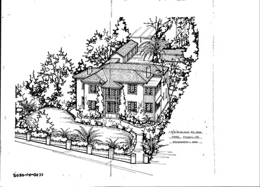
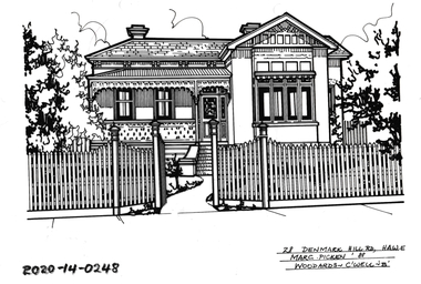
 Hawthorn Historical Society
Drawing - Property Illustration, 2/ 10 Denmark Hill Road, Hawthorn
'After training as a Cartographic Draftsman within the mining industry, I worked as a property illustrator for real estate firms in the eastern suburbs of Melbourne for 23 years from 1983. I initially photographed houses with a Polaroid camera and made a 'thumbnail' sketch while there. The photos were used to scale off a sketch in pencil and then that sketch was overlaid with drafting film and the 'pen and ink' completed. The pens I used were the Rotring ‘Rapidigraph’ drafting pens. The ink was also made by Rotring (German).The film was ‘Rapidraw’, polyester drafting film, double matte. It takes a very fine line and doesn’t bleed. As well as house sketches, there were often floor plans and site plans ordered. Aerial sketches were ordered when the property needed an overall view.' (Margaret Picken, 2020)This property illustration is one of a series created by Margaret Picken for a range of real estate agents in Melbourne between c. 1983 and c. 2006. Each work is signed and dated by the artist.Gift of Margaret Picken, 2020Pen and ink property illustration on drafting film of 2/10 Denmark Hill Road, Hawthorn by Margaret Picken.2/10 Denmark Hill Road, Hawthorn, Margaret Picken '91. Woodards - C'well.artist - margaret picken 1950- -
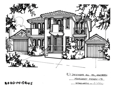
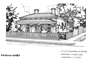 Hawthorn Historical Society
Drawing - Property Illustration, 17 & 17A Denmark Hill Road, Hawthorn
'After training as a Cartographic Draftsman within the mining industry, I worked as a property illustrator for real estate firms in the eastern suburbs of Melbourne for 23 years from 1983. I initially photographed houses with a Polaroid camera and made a 'thumbnail' sketch while there. The photos were used to scale off a sketch in pencil and then that sketch was overlaid with drafting film and the 'pen and ink' completed. The pens I used were the Rotring ‘Rapidigraph’ drafting pens. The ink was also made by Rotring (German).The film was ‘Rapidraw’, polyester drafting film, double matte. It takes a very fine line and doesn’t bleed. As well as house sketches, there were often floor plans and site plans ordered. Aerial sketches were ordered when the property needed an overall view.' (Margaret Picken, 2020)This property illustration is one of a series created by Margaret Picken for a range of real estate agents in Melbourne between c. 1983 and c. 2006. Each work is signed and dated by the artist.Gift of Margaret Picken, 2020Pen and ink property illustration on drafting film of 17 & 17A Denmark Hill Road, Hawthorn by Margaret Picken.17 & 17A Denmark Hill Road, Hawthorn, Margaret Picken 2000. Woodards - C'well.artist - margaret picken 1950- -
 Whitehorse Historical Society Inc.
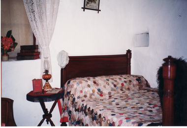
Photograph, Main Bedroom in Schwerkolt Cottage
Coloured photograph of main bedroom in Schwerkolt cottage bed and patchwork quilt.schwerkolt cottage & museum complex, nunawading & district historical society -
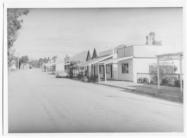
 Whitehorse Historical Society Inc.
Photograph, Corner South Parade & Main Street, Blackburn
Black and white photo of Corner South Parade and Main Street, Blackburnsouth parade, blackburn, main street -
Rutherglen Historical Society
Image, Main Street, East Rutherglen, 1909
Coloured postcard showing Main Street, Rutherglen with the Victoria Hotel in the foreground.main street, victoria hotel -
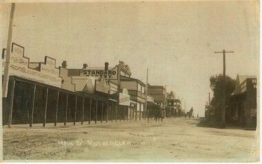 Rutherglen Historical Society
Image, Main Street Rutherglen, 1917
Photocopy of an old faded photograph of Main Street taken from the eastOn back of photo: "No. 10 Post Card dated 11/8/1917"main street -
 City of Kingston
Pamphlet - Colour, Farrow Falcon Press, Printers, Ozone Estate, Bluff Road, Hampton, c. 1940
Sales plan for land in the suburb of Hampton (Highett), bounded by Bluff Road, Wickham Road, Peterson Street and June Street. Includes Morley Street, Follett Avenue, and Parrett StreetThe developing urban area of Highett within the City of Kingston. This land sale pamphlet illustrates the subdivision of land within the municipality and the changing demographic of the district as new houses are constructed close to infrastructure.Colour pamphlet advertising for private sale the Ozone Estate, Bluff Road Hampton. Incorporates a map of the estate bordered by Bluff Road, Wickham Road, June Street and Peterson Street including Morley Street, Follett Avenue and Parrett Street.Handwritten in grey pencil on rear: Ozone Estateland sales, estate, highett, hampton -
 Whitehorse Historical Society Inc.
Photograph - Strip photo and photocopy, Railway Road Blackburn, 1/08/1976 12:00:00 AM
Railway Road Blackburn. East end.Railway Road Blackburn. East End.blackburn, railway road, shops -
Ballarat Tramway Museum
Functional object - Destination Roll, NSW Department of Road Transport and tramways, "Newcastle"
Destination roll use din a Newcastle tram - on linen, black background with various colours and white letters. Each destination 10" high. 6 joins in roll, each approx. 800 to 900 long section. Letters in caps. Destinations shown are: West Wal'send Wallsend and Platsburg New Lambton Lambton Broadmeadow Adamstown Waratah Merewether B'H (Beach) Newcastle Tighe's Hill Mayfield Glebe Boreas Road Special Depot Sport Grd Show Grd Racecourse Speedway Telford St Hamilton Depottram, trams, newcastle, destination roll -
 Hawthorn Historical Society
Drawing - Property Illustration, 28 Denmark Hill Road, Hawthorn
'After training as a Cartographic Draftsman within the mining industry, I worked as a property illustrator for real estate firms in the eastern suburbs of Melbourne for 23 years from 1983. I initially photographed houses with a Polaroid camera and made a 'thumbnail' sketch while there. The photos were used to scale off a sketch in pencil and then that sketch was overlaid with drafting film and the 'pen and ink' completed. The pens I used were the Rotring ‘Rapidigraph’ drafting pens. The ink was also made by Rotring (German).The film was ‘Rapidraw’, polyester drafting film, double matte. It takes a very fine line and doesn’t bleed. As well as house sketches, there were often floor plans and site plans ordered. Aerial sketches were ordered when the property needed an overall view.' (Margaret Picken, 2020)This property illustration is one of a series created by Margaret Picken for a range of real estate agents in Melbourne between c. 1983 and c. 2006. Each work is signed and dated by the artist.Gift of Margaret Picken, 2020Pen and ink property illustration on drafting film of 28 Denmark Hill Road, Hawthorn by Margaret Picken.28 Denmark Hill Road, Haw E, Marg Picken '88. Woodards - C'well - 'B'.artist - margaret picken 1950- -
 Eltham District Historical Society Inc
Photograph, George W. Bell, Message from 'Windy' Gale, Wild Dog Creek Road, Jan. 1962, Jan 1962
"Staying at Dinsdales up the hill, Windy" Building of Pensioners Cottages at St Andrews; for those burnt out in the 1962 bushfires. A voluntary scheme of Mavis Gill through the Kangaroo Ground Relief CommitteeBlack and white photo mounted on cardMessage from resident Wild Dog Creek Road Photo Geo. W. Bell, Jan. 1962victorian bushfires - 1962, bushfires, dick (windy) gale, fire damage - buildings, george w bell, houses, st andrews, wild dog creek road, mavis gill, pensioners cottages, bill dinsdale -
 Glen Eira Historical Society
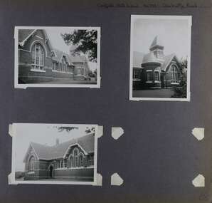
Album - Album page, Caulfield State School, No 773, Glen Huntly Road, Circa 1972
This photograph is part of the Caulfield Historical Album 1972. This album was created in approximately 1972 as part of a project by the Caulfield Historical Society to assist in identifying buildings worthy of preservation. The album is related to a Survey the Caulfield Historical Society developed in collaboration with the National Trust of Australia (Victoria) and Caulfield City Council to identify historic buildings within the City of Caulfield that warranted the protection of a National Trust Classification. Principal photographer thought to be Trevor Hart, member of Caulfield Historical Society. Most photographs were taken between 1966-1972 with a small number of photographs being older and from unknown sources. All photographs are black and white except where stated, with 386 photographs over 198 pages.From: Glen Eira Heritage Management Plan (1996) by Andrew Ward and Associates Caulfield State School No. 773 is important at the State level as the first of similar designs for small schools prepared by the Education Department under H.R. Bastow at Little Bendigo (1878), Glen Waverley (1880), Ascot (1882), Sandringham (1885) and Carlsrich (1892)·. It is a representative example of the Department's Gothic Revival designs, distinguished, however, by the semicircular treatment of the master's office, which compares with Portland (1879), Queensberry St Carlton (1880) and Footscray (1881). It has local significance as the earliest surviving Government School in Caulfield and as a centre for education from 1877, comparing with St. Mary's Jubilee School (qv) of 1887. The Caulfield State School of 1877, the horse tramway of 1889 and subsequently the electric trams were all events confirming the importance of Glenhuntly Road and the fledgling community of "Camden Town" wherein the City's commercial centre has its origins.Page 68 of Photograph Album with three exterior photographs (two portrait and one landscape) of one side of Caulfield State School with a fourth photo missing from the page.Hand written: Caulfield State School No. 773 Glenhuntly Road [top right] / 68 [bottom right] trevor hart, glen huntly road, caulfield state school, caulfield primary school, gothic revival, schools, caulfield south, arched window, tower, 1870's, camden town, red brick, curved windows, terracotta tiles, master's office, education, primary school, glenhuntly road, h r bastow -
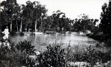 Whitehorse Historical Society Inc.
Photograph - B;ack and white photograph, Old Dam - Corner of Blackburn and Canterbury Road Blackburn, c. 1922
Dam on the corner of Canterbury and Blackburn Roads where the Bellbird Hospital now stands.Black & white photo of S.W. corner of Blackburn Road and Canterbury Road c1922. Mrs wellman is standing on rock.wellman mrs, blackburn road blackburn, canterbury road blackburn -
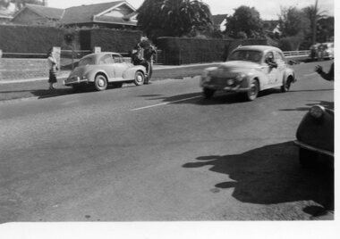 Surrey Hills Historical Society Collection
Digital photo, George L Coop, Redex trial on Whitehorse Road, Mont Albert, 1953, 1953
The Redex Reliability Trial 1953 -The first Redex round-Australia reliability trial covered of 6,500 miles (10,500 km), and had a first prize of £1,000. It attracted both amateur and professional drivers in a variety of cars. The route passed through Brisbane, Rockhampton, Townsville, Darwin, Alice Springs, Adelaide and Melbourne before returning to Sydney and attracted much public interest. At the time the idea of driving huge distances around the country in ordinary cars was novel and the logistics were challenging. In many parts of the country there simply wasn’t adequate accommodation or suitably located refuelling stops. The Shell Company facilitated the race by placing petrol dumps along the 5000 km route between Townsville and Adelaide. The race began at the Sydney Showground on 30 August when 192 cars left at three-minute intervals. Of the twenty top finalists, two thirds were sponsored. Ken Tubman and John Marshall won the trial in a Peugeot 203. However the Peugeot in this photo does not appear to be their car, judging by official photos of them with their vehicle, taken at the end of the trial. The Peugeot 203 was a popular car at the time and its reputation was enhanced after winning the trial. A black & white photo taken in Whitehorse Road, Mont Albert during the 1953 Redex Trial as a Peugeot 203 is passing 688 Whitehorse Road on the extreme left. The Peugeot 203 appears to have advertising on its panels indicating it was a competitor in the trial. On the far side of the road is a Morris Minor with a hatted man sitting on the bonnet, a woman standing close by and another man taking a photo of the passing cars. The houses in the background are partly obcsured by large hedges.george coop, mont albert, morris minor, redex trail, whitehorse road, peugeot 203 -
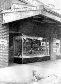 Surrey Hills Historical Society Collection
Photograph, Emma and William Atkinson's mixed business at 815 Whitehorse Road
Emma was born in East Doncaster in 1903, the daughter of Carl Heinrich Uebergang and Sarah Buck. Emma’s grandparents were pioneers in Doncaster from 1855 and her father had an orchard in Andersons Creek Road. Mr & Mrs Atkinson had a green-grocery business and general store at 815 Whitehorse Road, almost on the corner of Elgar Road from 1930 until about 1950 . Lloyd's butchers business was next door. In retirement the couple lived at 63 Zetland Road, Mont Albert and William continued to work as an orchard hand. Emma died in 2000 and is buried in Templestowe Cemetery. (See file for further details).A black and white photograph of a shop front. The verandah advertises "tobacco and cigarettes", "Minties", "Fruiterer". A small dog is standing on the pavement.lloyds butchers, elgar road, whitehorse road, box hill, animals, william james atkinson (mr), fruiterer and greengrocer, emma gerte uebergang (miss), emma gertrude uebergang (miss) -
 Whitehorse Historical Society Inc.
Photograph, Deep Creek Road, Mitcham, 1/09/2000 12:00:00 AM
Black and white photo of View East along Deep Creek Road, Mitcham, along South side of creek.mitcham -
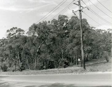
 Whitehorse Historical Society Inc.
Photograph, Deep Creek Road, 1/04/2001 12:00:00 AM
Coloured photograph looking from Schwerkolt Cottage across Deep Creek Road to start of construction of new Bridge.deep creek road, mitcham