Showing 8242 items
matching mallacoota-captains-point
-
 Lakes Entrance Regional Historical Society (operating as Lakes Entrance History Centre & Museum)
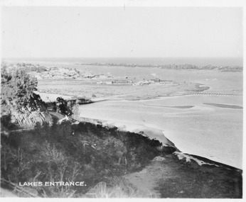
Postcard, 1940c
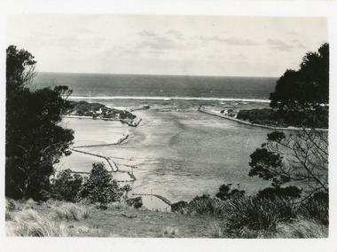
2 x identical mini postcards collected 6.5 x 9|1 x photographic print copy 18.5 x 25Black and white small format postcard of the man-made entrance from Bass Strait to the Gippsland Lakes, taken from Jemmys Point. It shows the rock groynes at Bullock Island and North Arm entrance. Lakes Entrance Victoriaislands, waterways, topography -
 Lakes Entrance Regional Historical Society (operating as Lakes Entrance History Centre & Museum)
Photograph, Fish Marie, 1995
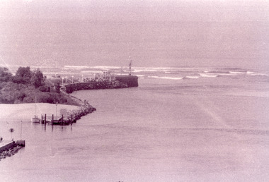
Black and white photograph of the Eastern Pier, taken from Jemmys Point. It shows the rock wall of the pier, rock groynes at the entrance to Cunninghame Arm behind which dredged sand has been dumped. Lakes Entrance Victoriaoccupation, waterways, machinery -
 Lakes Entrance Regional Historical Society (operating as Lakes Entrance History Centre & Museum)
Photograph, 1979
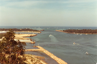
The king of the straits, offshore powerboat race with Lakes entrance as a destination was not repeated due to adverse weather conditionsColour photograph of the entrance, Bullock Island and Reeves Channel. Taken from Jemmys Point during the King of the Strait offshore powerboat race. It also shows the built up groynes at the entrance to the North Arm. Lakes Entrance Victoriafishing industry, waterways -
 Lakes Entrance Regional Historical Society (operating as Lakes Entrance History Centre & Museum)
Photograph, 1937
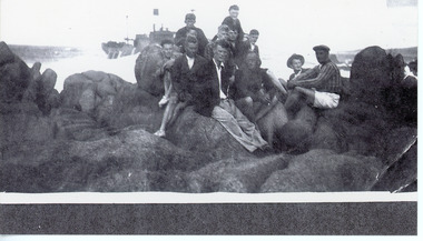
Some men identifiedBlack and white print of group of eleven men seated on rocky shore near the SS Savos, at Cape Everard, Point Hicks. Image shows the ships funnel still in place, vessel facing west. Lakes Entrance Victoriacoast, fishing industry, ocean, ships and shipping -
 Lakes Entrance Regional Historical Society (operating as Lakes Entrance History Centre & Museum)
Postcard, Valentine Series, 1930c
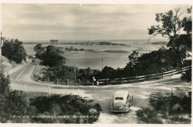
Black and white postcard of a bend in the Princes Highway as it winds around Jemmys Point, car parked beside highway, two people leaning on post and rail fence, Bullock Island and Lakes Entrance in the distance. Lakes Entrance VictoriaPrinces Highway Lakes Entrancefences, transport, roads and streets -
 Lakes Entrance Regional Historical Society (operating as Lakes Entrance History Centre & Museum)
Postcard, Bulmer H D, 1950c
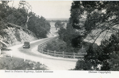
Black and white postcard of the Princes Highway as it winds around Jemmys Point. A motor car driving up the hill between steep road cutting and post and rail fence. View of the lake and ocean in the distance. Lakes Entrance VictoriaBend in Princes Highway, Lakes Entranceislands, fences, waterways, roads and streets -
 Lakes Entrance Regional Historical Society (operating as Lakes Entrance History Centre & Museum)
Photograph, 1995c
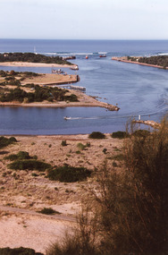
Colour photograph of the entrance from Bass Strait to the Gippsland. It shows the western and of Bullock Island and the built up area below Jemmys Point, all made during dredging operations over many years. Lakes Entrance Victoriafishing industry, islands, land reclamation, waterways -
 Lakes Entrance Regional Historical Society (operating as Lakes Entrance History Centre & Museum)
Postcard, 1920c
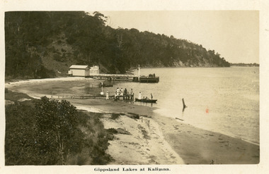
Personal message on back of postcardBlack and white postcard of Kalimna Jetty. It shows a jetty and landing with sheds, also shows seven people on rustic jetty in middle of photo, four people in boat. Jemmys Point road cutting in background. Lakes Entrance VictoriaGippsland Lakes at Kalimnajetties, waterways, tourism, boats and boating -
 Lakes Entrance Regional Historical Society (operating as Lakes Entrance History Centre & Museum)
Photograph, M Holding, 2006
Colour photograph showing the corner of Esplanade and Barkes Avenue with the Post Office on the Eastern corner and Centre Point Arcade on the Western corner taken when the main arcade shop was occupied by camping and Leisure business Lakes Entrance Victoriabusinesses, accommodation -
 Lakes Entrance Regional Historical Society (operating as Lakes Entrance History Centre & Museum)
Postcard, 1930c
Sepia toned small format postcard of a view from Jemmys Point, showing the road cutting around Kalimna Hill, North Arm bridge, town of Lakes Entrance, Cunninghame Arm and sand hummocks, Lakes Entrance VictoriaLakes Entrancewaterways, township, roads and streets -
 Ballarat Tramway Museum
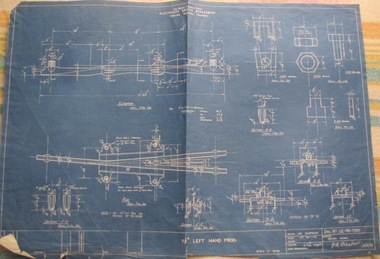
Drawing, State Electricity Commission of Victoria (SECV), "Geelong – 7 1/2o left hand frog", 1943
Used in tramway power supply overhead.Yields information about the details of a the point frog used in the overhead in Geelong. Similar equipment used in Ballarat and Bendigo.Blueprint of SEC drawing No. GE-T6-7380 "Geelong – 7 1/2o left-hand frog", dated 31/1/1943. Details of a the point frog used in the overhead in Geelong. Similar equipment used in Ballarat and Bendigo.Has “107” in biro in top right hand corner. Has "Recorded in Drawing" office stamp on rear.overhead, trolley wire, equipment -
 Bendigo Historical Society Inc.
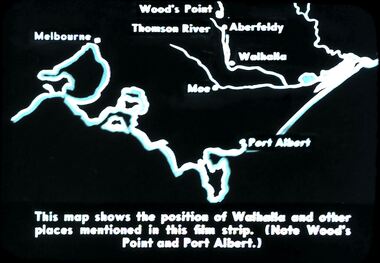
Slide - DIGGERS & MINING. DIGGERS AND MINERS, c1850s
Diggers & Mining. Diggers and miners. Walhalla - Gold Town. This map shows the position of Walhalla and other places mentioned in this film strip. (Note Wood's Point and Port Albert.) Markings: 6 995 WAL. Used as a teaching aid.hanimounteducation, tertiary, goldfields -
 Kew Historical Society Inc
Photograph - Flooding of the Yarra Valley at Kew East, 1974
Flooding of the Yarra Valley, including that section of the Yarra bordering Kew and Kew East in the north and west of the municipality, was a regular occurrence. Extreme flood events of the Yarra River are recorded to have occurred in 1891, 1901, 1916, 1923 and 1934. The Municipality of Kew's response to these floods was to enact planning decisions restricting residential development in flood prone areas following the floods of 1916, 1921 and 1934. While floods continued after the development of the Upper Yarra Reservoir (construction 1948-57), the regularity and extent of these inundations diminished. During the nineteenth century, the land abutting the south side of the Yarra in Kew was devoted to dairy farming. In the twentieth century, before and after the construction of the Eastern Freeway, much of this low-lying area was used as golf courses and public parks.Late example of the capacity of the Yarra Valley at Kew to flood, even though drainage works and the Upper Yarra Reservoir had reduced their regularity.Original black and white print photograph of the low-lying land at East Kew under floodwater on 16 May 1974. The vantage point of the photographer is Lister Street. Flooding was caused by overflowing water in Glass' Creek and the River Yarra. Annotation verso: "Lister Street looking north / Flood level / 16 May 1974 11.30am / R.L. 46.04"hays paddock, floods, yarra river, glass' creek, lister street -
 Kew Historical Society Inc
Photograph - Flooding of the Yarra Valley at Kew East, 1974
Flooding of the Yarra Valley, including that section of the Yarra bordering Kew and Kew East in the north and west of the municipality, was a regular occurrence. Extreme flood events of the Yarra River are recorded to have occurred in 1891, 1901, 1916, 1923 and 1934. The Municipality of Kew's response to these floods was to enact planning decisions restricting residential development in flood prone areas following the floods of 1916, 1921 and 1934. While floods continued after the development of the Upper Yarra Reservoir (construction 1948-57), the regularity and extent of these inundations diminished. During the nineteenth century, the land abutting the south side of the Yarra in Kew was devoted to dairy farming. In the twentieth century, before and after the construction of the Eastern Freeway, much of this low-lying area was used as golf courses and public parks.Late example of the capacity of the Yarra Valley at Kew to flood, even though drainage works and the Upper Yarra Reservoir had reduced their regularity.Original black and white print photograph of the low-lying land at East Kew under floodwater on 16 May 1974. The vantage point of the photographer is Lister Street. Flooding was caused by overflowing water in Glass' Creek and the River Yarra. Annotation verso: "Lister St looking same as No.3 / 16 May 1974 11.30"floods, yarra river, glass' creek, lister street -
 Maldon Vintage Machinery Museum Inc
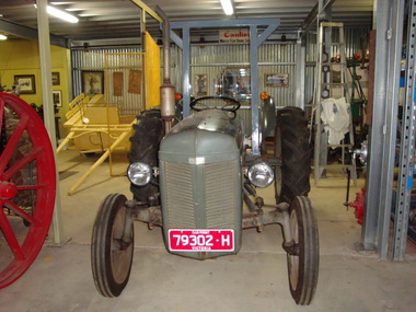
Fergie Tractor
Grey Ferguson tractor restored to working order with a detachable grader blade. A rollover protection bar has been added to comply with modern regulations for safety. Three point linkage and 3 new tyres. Club permit registration. Metal plates on front and sides "Ferguson". Serial No. plate on steering column mount etched No. "533? "........." Henry Ferguson / ........ / TE14 "351?".rural industry - farm machinery; -
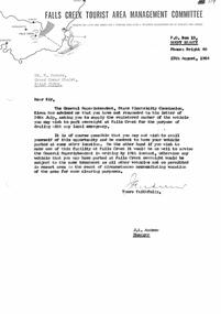 Falls Creek Historical Society
Document - S.E.C. Asked For Registered Number Of Vehicles Parked Overnight, 13.08.1964
Bob (Herman) Hymans (a former member of the Royal Netherlands Navy) was born in Bloemendaal, Holland on 30th September 1922. During World War II he fought against the Japanese in the Dutch East Indies (now Indonesia) and was imprisoned in Changi and on the Burma Railway. After gaining qualifications as a Ski Instructor, Bob arrived in Falls Creek in July 1950. Working as an Instructor and Supervisor at Bogong Lodge, Bob decided his future was in accommodation. He was successful in negotiating an indenture for land from the State Electricity Commission (SEC). It took Bob two years to build his Grand Coeur Chalet but, tragically, it was burned down in August 1961. Bob also built the first Chairlift in Australia. This was a single chairlift and the structure was built from wooden electricity poles. He was constantly full of new ideas and proposals for the village. Bob Hymans die on 7th July 2007. This Collection of documents and letters tells the story of Bob's endeavours to develop Falls Creek into the ski village it is today.This letter is significant because it reflects the relationship between Bob Hymans and the Management Committee.A letter from the Management Committee pointing out that Mr Hymans has failed to provide his car registration number to the SEC as requested. If not provided his vehicle will not be able to park his vehicle overnight within Falls Creek.falls creek tourist area management committee, bob hymans, falls creek administration -
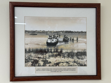 The 5th/6th Battalion Royal Victoria Regiment Historical Collection
Photograph - Photograph of soldiers of 2/6th Battalion on exercise in 1943
A photograph 2/6th Battalion soldiers on exercise. The explanation text stating "A Bren carrier from the 2/6th Battalion comes ashore during beach landing exercises at point Walter, Western Australia, 6th February 1943." -
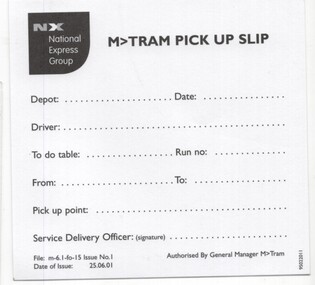 Melbourne Tram Museum
Document - Instruction, M>Tram, "M>Tram Pick up slip", Jun. 2001
Instruction - titled "M>Tram Pick up slip", taken from a pad of sheets, advising drivers which table / Run no to operate on a date and from which point. dated 25/6/2001. 3 copies held.trams, tramways, m>tram, national express, drivers, table cards, operations -
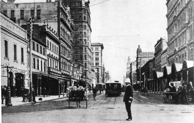 Melbourne Tram Museum
Photograph - Black & White Photograph/s, Tramway Museum Society of Victoria (TMSV), c1975
Black & White Photograph of a postcard made by the TMSV Sales of the Elizabeth St terminus with a cable car set shunting and a policeman on point duty. Looking north along Elizabeth St from Flinders St. 2 copies held.trams, tramways, elizabeth st, police, cable trams -
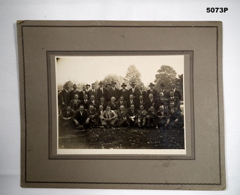 Bendigo Military Museum
Photograph - PHOTOGRAPH 38th BN, Post 1920
The photo was taken Post WW1 and believed to be 38th Bn men, non identifiable at this point. It was in a collection relating to the 38th Bn Social Club Melbourne.Photo on heavy grey card with two ornate black edgings, there are 37 men in 3 rows in a park setting.photographs, 38th bn, -
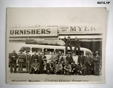 Bendigo Military Museum
Photograph - PHOTOGRAPHS 38th BN, 1) 1948
.1) The 38th group photo was most likely taken in Pall Mall Bendigo in front of the Myers store. Only one men is identifiable at this point..1) Photo B & W rectangular shape showing a group of men 23 in total standing beside a bus, two sitting on top. .2) Photo B& W rectangular shape showing one to the two Colours of the 38th BN AIF..1) “Melbourne Members. Bendigo Reunion October 1948”photographs, 38th bn -
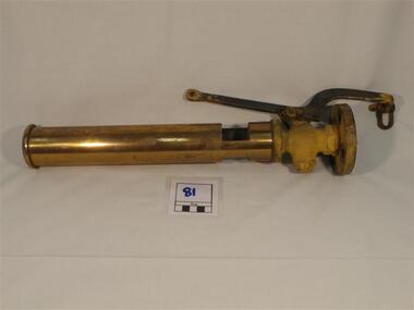 Phillip Island and District Historical Society Inc.
Steam whistle
Steam whistle which sits near the ships funnel from the 'Killara' which was a car ferry from Cowes to Stony Point from 1933.Brass and steel ships whistlephillip island, cowes, stony point, killara, steam whistle, car ferry -
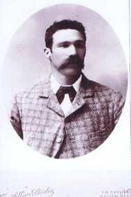 Greensborough Historical Society
Photograph - Digital Image, Benjamin Partington, 1899c
Unidentified photograph, (Verified to by Faye Partington that it Benjamin (born at Point Lookout). Lived and worked at Willis Vale on the farm and orchards. Married at age 34.Charles Partington and family came to Melbourne in the 1840s and moved to Greensborough where they farmed along the Plenty River. Descendants still live in Greensborough.Digital copy of black and white studio photograph. -
Moorabbin Air Museum
Manual (item) - Bristol Beaufighter TFX Pilot's Manual, Pilot's Notes for Beaufighter TFX Two Hercules XVII or XVIII engines
3rd edition, AP 1721H-P.N. "$9" is pencilled in on the inside of the front cover, suggesting the item was sold at some point before arriving at the museum. -
 Galen Catholic College
Galen Catholic College Mass, 1994
This series of photos features a cross as the focal point of the ceremony. This school mass in 1994 took place in the area now partly occupied by our dome. galen catholic college, galen college, catholic mass, mass, 1994 -
 Torquay and District Historical Society
Photograph (copy)
Photograph appears to have been copied from an unknown newspaper but is believed to show the Joseph H Scammell on the reef at Point Danger Torquay in 1891.Black and White photocopyshipwrecks great ocean road victoria -
 Torquay and District Historical Society
Spirit Stove, Scammell Collection, Pre 1890
An original artefact from the Joseph H Scammell purchased at an auction of the ships cargo after the ship was wrecked off Point Danger Torquay in 1891.The wreck of the Scammell was a significant event in Torquays history.Small silver spirit stove with four legs supporting a cradle over a spirit burner.shipwrecks great ocean road victoria -
Lakes Entrance Regional Historical Society (operating as Lakes Entrance History Centre & Museum)
Postcard, 1930 c
Also three small black and white postcards taken from same viewing point Metung donated by Peter Harper 04462.1, 04462.2, 04462.3Black and white postcard of timbered shore of Chinamans Creek looking south towards Bancroft Bay Metung Victoriaroads and streets -
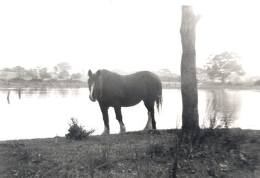 City of Kingston
Photograph - Digital image, Black and white, c. 1950
Horse standing by a lake on the property of the Methodist Children's Homes, Cheltenham. The photograph is taken from Tennyson Street, looking towards Point Nepean Road.This image shows the land in Cheltenham, that later became Southland Shopping Centre. The land originally belonged to the Methodist Church, who operated a Children's Home on the property.Black and white image of a horse standing next to a tree trunk by a lake. cheltenham, methodist children's homes, southland, environment -
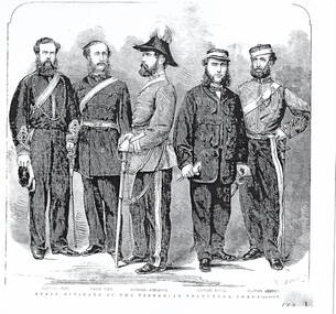 Hume City Civic Collection
Drawing, S.Calvert, STAFF OFFICERS OF THE VICTORIAN VOLUNTEER FORCE
The five men who were staff officers of the Victorian Volunteer Force were Captain Snee, Major Pitt, Colonel Anderson, Captain Payne and Captain Burton. The Victorian Volunteer Force was the main defence force in Victoria after the withdrawal the Imperial Troops in 1870. IN that same year a Permanent Artillery Corps ( Victorian Artillery) was also formed. The Volunteer force was disbanded in 1884 and replaced by the Victorian Militia force. The members were paid and enrolled for a set term.A black and white photograph of an etching of 5 officers in the Victorian Volunteers Force.victorian volunteer force., victorian artillery, victoria militia, military history