Showing 4551 items matching "historical map"
-
 Bendigo Historical Society Inc.
Map - PART PARISHES OF SANDHURST MARONG AND NERRING, No date visible
Map: Section of a Parish plan of Bendigo, covering Ironbark, Eaglehawk and Myers Flat ( number 145 in Map Cupboard 1)map, bendigo, city streets, parish of sandhurst, parish of marong, parish of nerring, ironbark, eaglehawk, myers flat -
Bendigo Historical Society Inc.
Map - PARISH OF HUNTLY(PART) AND SANDHURST(PART), No date visible
Map: Part of parish plan of Bendigo, covering Strathdale, White Hills, Huntly and North Bendigo ( number 144 in Map Cupboard 1)map, bendigo, city streets, parish of hunlty, parish of sandhurst, strathdale, white hills, huntly, north bendigo -
Bendigo Historical Society Inc.
Document - MAP INDEX SHEETS, No dates on item
Map index sheets for Military survey Inch to the Mile scale maps.Covering Victoria , Tasmania, Northern Territory,Queensland and New South Wales. There are Four sheets numbered 9156 a, b , c and d. These are photocopied sheets, NOT originalsdocument, map index sheets, inch to the mile index sheets -
 Bendigo Historical Society Inc.
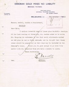
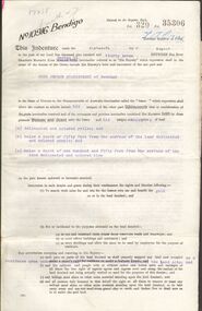
Document - MCCOLL, RANKIN AND STANISTREET COLLECTION: DEBORAH EXTENDED GOLD MINING CO. NL, 1940
McColl Rankin & Stanistreet, Deborah Extended Gold Mining Co. No Liability, Lease. Inscription: Mortgagee under Mortgage N'bd... has consented to this Lease, See consent endorsed heron (signed) F O Hewison Assistant Registrar, Registrar of Titles 14 May 1941. Leases Copy. Other signatures: Donald McKinnon, Jean Woods, Jamie Jepson, Angus Mackay, J Stanistreet, A Gilcrist, ? Healy. Common Seal for: The Bank of Australasia and Deborah Ext Gold Mining Co NL. 2 maps of mine location.organization, mining, deborah extended gold mining co nl, mccoll rankin & stanistreet, deborah extended gold mining co nl lease -
Bendigo Historical Society Inc.
Map - CITY OF BENDIGO SHEET 2, No date visible
Map: City of Bendigo Sheet 2, Town plan ( number 143 in Map Cupboard 1)map, city of bendigo sheet 2, city streets -
Bendigo Historical Society Inc.
Map - BENDIGO SHEET 12, Reproduced 1961
Map; Bendigo Sheet 12, Parish of Sandhurst , County of Bendigo, Parish plan, Scale 2 chains to 1 inch ( number 142 in Map Cupboard 1)map, bendigo, city streets, bendigo sheet 12, parish of sandhurst , county of bendigo -
Bendigo Historical Society Inc.
Map - INFANCY OF BENDIGO, Original dated 28/10/1890
Map: Photocopy of the First sketch map of the Bendigo Diggings. Has been assembled from several photocopies taped together. Laid before the Frencham Committee by William Sandbach , a witness, 18 September 1890. There are Two of these maps. ( x ref 5673 , 8235 , Box 83 , 9077 )map, bendigo, city streets, infancy of bendigo, gold diggings, henry frencham, william sandbach, where was gold first found -
Bendigo Historical Society Inc.
Map - PLAN OF THE TOWNSHIP OF SANDHURST(PHOTOCOPY)
Map: Photocopy of a plan of the Township of Sandhurst. Dated 26 July 1854 ( number 141 in Map Cupboard 1)map, bendigo, city streets, township of sandhurst, early bendigo, city streets -
Bendigo Historical Society Inc.
Map - JANIEMBER WEST, 18/02/1913
Map: Parish of Janiember West, County of Bendigo ( number 140 in Map Cupboard 1)map, bendigo, rural, janiember west , county of bendigo -
Bendigo Historical Society Inc.
Map - NERRING, 15/06/1937
Map: Parish of Nerring, County of Bendigo. Parish plan Canvas backed ( number 139 in Map Cupboard 1)map, bendigo, rural, nerring, county of bendigo -
Bendigo Historical Society Inc.
Map - HUNTLY, 9th June 1880
Map:Huntly, County of Bendigo. Parish plan Canvas backed. ( number 138 in Map Cupboard 1)map, bendigo, city streets, huntly, county of bendigo -
Bendigo Historical Society Inc.
Map - BENDIGO (PART), No date visible
Map: Portion of Bendigo parish plan, showing from Murphy St. East to Bob St and between rail line to old saleyards to the old Heathcote line Canvas backed.map, bendigo, city streets, bendig parish plan , bendigo city streets -
Bendigo Historical Society Inc.
Map - BENDIGO SHEET 2, No date visible
Map: Parish plan showing portion of Bendigo city, West from the Echuca rail line, showing lake weeroona ( number 136 in Map Cupboard 1)map, bendigo, city streets, bendigo sheet 2, bendigo streets -
Bendigo Historical Society Inc.
Map - PORTION OF ELMORE ESTATE, 19/10/1920
Map: Portion of Elmore Estate, Parish of Egerton, County of Bendigo. Parish plan Canvas backed ( number 135 in Map Cupboard 1)map, bendigo, rural, elmore estate, egerton, county of bendigo -
Bendigo Historical Society Inc.
Map - PORTION OF ELMORE ESTATE, 19/10/1920
Map: Portion of Elmore Estate, Parishes of Warragamba and Diggorra, County of Bendigo. Parish plan Canvas backed ( number 143 in Map Cupboard 1)map, bendigo, rural, elmore estate , warragamba, diggorra , county of bendigo. -
Bendigo Historical Society Inc.
Map - SUBDIVISION OF STERNBERG'S ESTATE, 24/06/1920
Map: Subdivision of Sternberg's Estate, Crown Allotments 75, 76, 76A, 76B and 77, Parish of Rochester West, County of Bendigo. Parish plan Canvas backed ( number 133 in Map Cupboard 1)map, bendigo, rural, sternberg's, crown allotments 75, 76, 76a, 76b, 77, rochester west, county of bendigo -
Bendigo Historical Society Inc.
Map - MAHER'S AND PRETTY'S ESTATE, 8/02/1926
Map: Maher's and Pretty's Estate, Parish of Toolamba West, County of Rodney. Parish plan Canvas backed. ( number 131 in Map Cupboard 1)map, rodney, rural, maher's , pretty's, toolamba west, county of rodney -
Bendigo Historical Society Inc.
Map - PORTION OF ELMORE ESTATE, 19/10/1920
Map: Portion of Elmore Estate, Parish of Minto, County of Bendigo. Parish plan Canvas backed ( number 131 in Map Cupboard 1)map, bendigo, rural, elmore estate, minto, county of bendigo -
Bendigo Historical Society Inc.
Map - BAMAWM ESTATE, 12/.08/1912
Map: Bamawm Estate, Acquired under Closer settlements Acts 1904, County of Bendigo. Parish Plan Canvas backed. ( number 130 in Map Cupboard 1)map, bendigo, rural, bamawm estate, closer settlement acts 1904, county of bendigo -
Bendigo Historical Society Inc.
Map - BAMAWM ESTATE, 24/02/1931
Map: Bamawm Estate, Aquired under closer settlement Act 1904, County of Bendigo. Parish plan Canvas backed ( number 129 in Map Cupboard 1)map, bendigo, rural, bamawm estate, closer settlement acts 1904, county of bendigo -
 Bendigo Historical Society Inc.
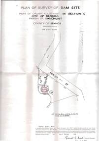
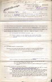
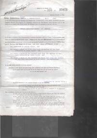
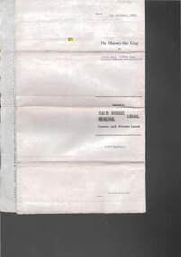
Document - MCCOLL, RANKIN AND STANISTREET COLLECTION: DEBORAH EXTENDED GOLD MINING COMPANY N/L GOLD MINING LEASE, 18 April 1957
Document Deborah Extended Gold Mining Company N/L document - gold mining lease document, Vol 334 071, dated 18 April 1957, 4 pages with map. Map adjoins Bendigo Cemetery. Lease between Deborah Extended Gold Mining Company N/L and the State of Victoria. No. 11339, Vol 334 Fol 071.organization, mining, gold mining lease, deborah extended gold mine, gold mining lease -
 Bendigo Historical Society Inc.
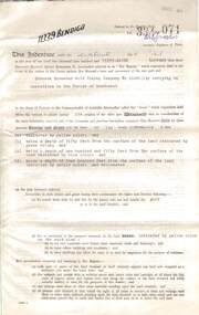
Document - MCCOLL, RANKIN AND STANISTREET COLLECTION: GOLD MINING LEASE, 1937
Document: McColl, Rankin and Stanistreet: document - gold mining lease document, 3 pages with map. Map adjoins Upper California Gully Road. Sheaf of 5 letters attached to inside of document with pin. Lease between Herbert Jackson Leed of Bendigo and State of Victoria. No. 10901, Vol 320 Fol 35364.organization, mining, gold mining lease, mccoll, rankin and stanistreet: herbert jackson leed, gold mining lease -
 Bendigo Historical Society Inc.
Document - MCCOLL, RANKIN AND STANISTREET COLLECTION: DEBORAH GOLD MINES NL GOLD MINING LEASE DOC, 1941
Document: McColl, Rankin and Stanistreet: Gold Mining Lease Private Land, 11089 Bendigo on front of document., Deborah Gold Mines NL - 3 pages, with map. Lease adjoins Railway Reserve, Breen Street. Transferred to North Deborah Mining Company NL on 9th. October, 1950. No. 11089, Vol 326 Fol 35941.organization, mining, gold mining lease, mccoll, rankin and stanistreet:, deborah gold mines nl, north deborah mining company nl, gold mining, lease -
 Bendigo Historical Society Inc.
Document - MCCOLL, RANKIN AND STANISTREET COLLECTION: DEBORAH GOLD MINES NL GOLD MINING LEASE ON PRIVATE LAND, 1941
Document McColl, Rankin and Stanistreet: - 3 page lease document Deborah Gold Mines NL, with map., Lease adjoins Railway Reserve, Breen Street, Bendigo. Transferred to North Deborah Mining Company NL of Charing Cross, Bendigo on 9th. Oct. 1950. No. 11013, Vol 323, Fol 35696.organization, mining, gold mining lease documents, mccoll, rankin and stanistreet:, deborah gold mines nl, north deborah mining company nl, gold mining, lease document -
 Bendigo Historical Society Inc.
Document - MCCOLL, RANKIN AND STANISTREET COLLECTION: GOLD MINING LEASE RONALD ALEXANDER RANKIN, 1941
Document: McColl, Rankin and Stanistreet: lease document between Ronald Alexander Rankin of Bendigo and the State of Victoria. 3 pages with map - lease adjoins Bellevue Road. Lease transferred to Deborah Gold Mines NL in 1945.organization, mining, gold mining lease, mccoll, rankin and stanistreet:, ronald alexander rankin, lease document, gold mining -
 Bendigo Historical Society Inc.
Document - MCCOLL, RANKIN AND STANISTREET COLLECTION:SOUTH NELL GWYNNE GOLD MINING COMPANY NO LIABILITY, 1940
Document: South Nell Gwynne Gold Mining Company No Liability - gold mining lease document no. 11074 Bendigo. Document of 3 pages with map insert.organization, mining, south nell gwynne gold mining co., bendigo, mccoll, rankin & stanistreet -
 Bendigo Historical Society Inc.
Document - MCCOLL, RANKIN AND STANISTREET COLLECTION: DEBORAH GOLD MINE NL - LEASE DOCUMENTS, 1935, 1941
Document: McColl, Rankin and Stanistreet: lease documents. 12 pages of lease details, with attached map plan on no 9672 Bendigo. ( Abel and Eve Street marked )organization, mining, deborah gold mines nl, mccoll, rankin and stanistreet: deborah gold mines nl, gold mining, lease -
 Bendigo Historical Society Inc.
Document - MCCOLL, RANKIN AND STANISTREET COLLECTION: GOLD MINING LEASE CROWN LAND, 1937
Document : McColl, Rankin and Stanistreet: gold mining lease crown land 10916 Bendigo. Foolscap size document, includes map County of Bendigo, Parish of Mandurang. Dated 1937 between King George VI and John Jepson Stanistreet.person, mining, john jepson stanistreet, mccoll, rankin and stanistreet: bendigo, mining, goldmining, john stanistreet -
 Bendigo Historical Society Inc.
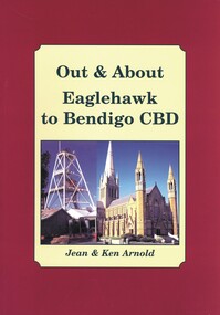
Book - OUT & ABOUT EAGLEHAWK TO BENDIGO CBD, 2007
Out & About Eaglehawk to Bendigo CBD .Plaques monuments, buildings, maps, buildings. 88 pages. Includes B&W photosJean & Ken Arnoldcottage, miners, plaques monuments, buildings, maps, buildings, bendigo and district -
 Bendigo Historical Society Inc.
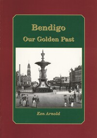
Book - BENDIGO OUR GOLDEN PAST, 2007
Bendigo Our Golden Past. Signed by Ken Arnold 2007. History of Bendigo. Photographs: black and white. Street maps, copy opf painting. 80 pages. Signed by: Ken Arnold, December 2007. 80 pages.Ken Arnoldbendigo, history, bendigo & district, history of bendigo