Showing 6303 items
matching what's on
-
 Rutherglen Historical Society
Document - School Records - Individuals, Higher Elementary School, Rutherglen, Lawrence, Jeffrey James, 1951
From School records, some more complete than others. Reports should contain information on the pupil's school work and give details of what they did when they left school. They should also show the name of a parent and the occupation. All sheets are indexed on a spreadsheet at the Common School Museum.Individual school records of the pupils of the Higher Elementary School, Rutherglen.rutherglen higher elementary school, pupils, students, school reports -
Rutherglen Historical Society
Document - School Records - Individuals, Higher Elementary School, Rutherglen, Le Lievre, Alexander William, 1925
From School records, some more complete than others. Reports should contain information on the pupil's school work and give details of what they did when they left school. They should also show the name of a parent and the occupation. All sheets are indexed on a spreadsheet at the Common School Museum.Individual school records of the pupils of the Higher Elementary School, Rutherglen.rutherglen higher elementary school, pupils, students, school reports -
Rutherglen Historical Society
Document - School Records - Individuals, Higher Elementary School, Rutherglen, Le Lievre, Alfred Abraham, 1923
From School records, some more complete than others. Reports should contain information on the pupil's school work and give details of what they did when they left school. They should also show the name of a parent and the occupation. All sheets are indexed on a spreadsheet at the Common School Museum.Individual school records of the pupils of the Higher Elementary School, Rutherglen.rutherglen higher elementary school, pupils, students, school reports -
Rutherglen Historical Society
Document - School Records - Individuals, Higher Elementary School, Rutherglen, Le Lievre, Charles Andrew, 1923
From School records, some more complete than others. Reports should contain information on the pupil's school work and give details of what they did when they left school. They should also show the name of a parent and the occupation. All sheets are indexed on a spreadsheet at the Common School Museum.Individual school records of the pupils of the Higher Elementary School, Rutherglen.rutherglen higher elementary school, pupils, students, school reports -
Rutherglen Historical Society
Document - School Records - Individuals, Higher Elementary School, Rutherglen, Le Lievre, Frederick Albert, 1927
From School records, some more complete than others. Reports should contain information on the pupil's school work and give details of what they did when they left school. They should also show the name of a parent and the occupation. All sheets are indexed on a spreadsheet at the Common School Museum.Individual school records of the pupils of the Higher Elementary School, Rutherglen.rutherglen higher elementary school, pupils, students, school reports -
Rutherglen Historical Society
Document - School Records - Individuals, Higher Elementary School, Rutherglen, Le Lievre, Norman Arthur, 1929
From School records, some more complete than others. Reports should contain information on the pupil's school work and give details of what they did when they left school. They should also show the name of a parent and the occupation. All sheets are indexed on a spreadsheet at the Common School Museum.Individual school records of the pupils of the Higher Elementary School, Rutherglen.rutherglen higher elementary school, pupils, students, school reports -
Rutherglen Historical Society
Document - School Records - Individuals, Higher Elementary School, Rutherglen, Lease, George Edward, 1924
From School records, some more complete than others. Reports should contain information on the pupil's school work and give details of what they did when they left school. They should also show the name of a parent and the occupation. All sheets are indexed on a spreadsheet at the Common School Museum.Individual school records of the pupils of the Higher Elementary School, Rutherglen.rutherglen higher elementary school, pupils, students, school reports -
Rutherglen Historical Society
Document - School Records - Individuals, Higher Elementary School, Rutherglen, Lee, Carmel, 1940
From School records, some more complete than others. Reports should contain information on the pupil's school work and give details of what they did when they left school. They should also show the name of a parent and the occupation. All sheets are indexed on a spreadsheet at the Common School Museum.Individual school records of the pupils of the Higher Elementary School, Rutherglen.rutherglen higher elementary school, pupils, students, school reports -
Rutherglen Historical Society
Document - School Records - Individuals, Higher Elementary School, Rutherglen, Lee, Helen May, 1925
From School records, some more complete than others. Reports should contain information on the pupil's school work and give details of what they did when they left school. They should also show the name of a parent and the occupation. All sheets are indexed on a spreadsheet at the Common School Museum.Individual school records of the pupils of the Higher Elementary School, Rutherglen.rutherglen higher elementary school, pupils, students, school reports -
Rutherglen Historical Society
Document - School Records - Individuals, Higher Elementary School, Rutherglen, Lee, Joan, 1933
From School records, some more complete than others. Reports should contain information on the pupil's school work and give details of what they did when they left school. They should also show the name of a parent and the occupation. All sheets are indexed on a spreadsheet at the Common School Museum.Individual school records of the pupils of the Higher Elementary School, Rutherglen.rutherglen higher elementary school, pupils, students, school reports -
Rutherglen Historical Society
Document - School Records - Individuals, Higher Elementary School, Rutherglen, Lee, John, 1923
From School records, some more complete than others. Reports should contain information on the pupil's school work and give details of what they did when they left school. They should also show the name of a parent and the occupation. All sheets are indexed on a spreadsheet at the Common School Museum.Individual school records of the pupils of the Higher Elementary School, Rutherglen.rutherglen higher elementary school, pupils, students, school reports -
Rutherglen Historical Society
Document - School Records - Individuals, Higher Elementary School, Rutherglen, Leighton, Arthur Douglas, 1951
From School records, some more complete than others. Reports should contain information on the pupil's school work and give details of what they did when they left school. They should also show the name of a parent and the occupation. All sheets are indexed on a spreadsheet at the Common School Museum.Individual school records of the pupils of the Higher Elementary School, Rutherglen.rutherglen higher elementary school, pupils, students, school reports -
Rutherglen Historical Society
Document - School Records - Individuals, Higher Elementary School, Rutherglen, Lemin, Phyllis, 1935
From School records, some more complete than others. Reports should contain information on the pupil's school work and give details of what they did when they left school. They should also show the name of a parent and the occupation. All sheets are indexed on a spreadsheet at the Common School Museum.Individual school records of the pupils of the Higher Elementary School, Rutherglen.rutherglen higher elementary school, pupils, students, school reports -
Rutherglen Historical Society
Document - School Records - Individuals, Higher Elementary School, Rutherglen, Lemin, Reginald James, 1928
From School records, some more complete than others. Reports should contain information on the pupil's school work and give details of what they did when they left school. They should also show the name of a parent and the occupation. All sheets are indexed on a spreadsheet at the Common School Museum.Individual school records of the pupils of the Higher Elementary School, Rutherglen.rutherglen higher elementary school, pupils, students, school reports -
Rutherglen Historical Society
Document - School Records - Individuals, Higher Elementary School, Rutherglen, Lord, Albert James, 1921
From School records, some more complete than others. Reports should contain information on the pupil's school work and give details of what they did when they left school. They should also show the name of a parent and the occupation. All sheets are indexed on a spreadsheet at the Common School Museum.Individual school records of the pupils of the Higher Elementary School, Rutherglen.rutherglen higher elementary school, pupils, students, school reports -
Rutherglen Historical Society
Document - School Records - Individuals, Higher Elementary School, Rutherglen, Lord, George Victor Alfred, 1927
From School records, some more complete than others. Reports should contain information on the pupil's school work and give details of what they did when they left school. They should also show the name of a parent and the occupation. All sheets are indexed on a spreadsheet at the Common School Museum.Individual school records of the pupils of the Higher Elementary School, Rutherglen.rutherglen higher elementary school, pupils, students, school reports -
Rutherglen Historical Society
Document - School Records - Individuals, Higher Elementary School, Rutherglen, Lord, Thelma, 1933
From School records, some more complete than others. Reports should contain information on the pupil's school work and give details of what they did when they left school. They should also show the name of a parent and the occupation. All sheets are indexed on a spreadsheet at the Common School Museum.Individual school records of the pupils of the Higher Elementary School, Rutherglen.rutherglen higher elementary school, pupils, students, school reports -
Rutherglen Historical Society
Document - School Records - Individuals, Higher Elementary School, Rutherglen, Lott, Francis George, 1921
From School records, some more complete than others. Reports should contain information on the pupil's school work and give details of what they did when they left school. They should also show the name of a parent and the occupation. All sheets are indexed on a spreadsheet at the Common School Museum.Individual school records of the pupils of the Higher Elementary School, Rutherglen.rutherglen higher elementary school, pupils, students, school reports -
Rutherglen Historical Society
Document - School Records - Individuals, Higher Elementary School, Rutherglen, Lott, Frederick W, 1926
From School records, some more complete than others. Reports should contain information on the pupil's school work and give details of what they did when they left school. They should also show the name of a parent and the occupation. All sheets are indexed on a spreadsheet at the Common School Museum.Individual school records of the pupils of the Higher Elementary School, Rutherglen.rutherglen higher elementary school, pupils, students, school reports -
 Vision Australia
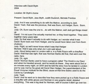
Audio - Sound recording, Interview with David Blyth by Judith Buckrich, 2004
Oral history interview and partial transcript of David Blyth by Judith Buckrich, with Jess Blyth and Michele Prentice. Recorded as part of 'Lighthouse on the Boulevard'. Former students and staff recall their days at RVIB, the impact of what they learned and experienced there, and how the attitudes to blindness and low vision changed over the years. 4 audio recordings of recollections from former RVIB attendeesroyal victorian institute for the blind, david blyth, oral history, judith buckrich, michele prentice, jess blyth -
 Melbourne Legacy
Pamphlet - Document, brochure, LEGACY dedicated to the care of ex-servicemen's widows and their children, 1966?
This is an example of Melbourne Legacy promotional material that was issued to inform the public on the work of Legacy. It includes the story of Legacy and what Legacy does. It was issued for the East Gippsland Group of Junior Legacy in Bairnsdale and is very similar to one at 01449 for Melbourne Legacy so the date is assumed to be the approximately same year.An example of promotional material issued by Legacy in 1966.Brochure x 4 pages to promote Legacy in 1966(?) with a black and white photo of a mother and two children surrounded by light blue on the cover.legacy promotion, fundraising -
 Vision Australia
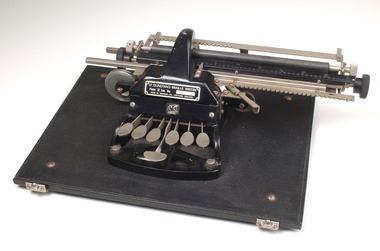
Equipment - Object, Redwing, St Dunstans Mark II, 1920's
The St Dunstans braille writer was modelled on the German Picht model, which enabled the writer to read what was written immediately by place the embossed character upwards of the carriage. Named after the organisation, it used a different finger technique than the Stainsby-Wayne machine that was predominantly available, and was lighter to carry.Black and silver Braille typewriter, with six keys and a large key (space bar) in front. At the back of the keys is a roller arrangement (similar to a typewriter) where paper is placed.St Dunstans Mark II. Ser. No. 575braille equipment, assistive devices -
 Ballarat Fire Brigade
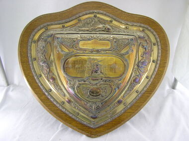
Trophy
Trophy was won at the Geelong Fire Brigade Jubilee in 1904. This would have been a demonstartion to celebrate the 50th Anniversary of the Geelong brigade which formed in 1854Silver shield mounted on a wooden backing board. Trophy was won by Ballarat Fire Brigade at the Geelong Fire Brigade Jubilee in 1904. Trophy was donated by Merrywetather & sons Lim. Trophy has a Lion at the top centre, angels on both the left and right sides. In the centre is a horse drawn fire appliance (assumed a Merryweather steam pumper) drawn by 2 horses through what appears to be a town square. There are 3 fireman standing on the front of the appliance and 1 on the rear. There are various other branches, leaves etc. that make up the remainder of the decorations on the sheild. Item is very similar to item 020.1904 / GEELONG FIRE BRIGADE JUBILEE / COMPETITION / PRESENTED / BY / Merryweather & Sons Lim1904, geelong fire brigade, geelong fire brigade jubilee, merrywether and sons lim, elkington and co -
Federation University Historical Collection
Book - Astronomy, Richard A. Proctor, Other Worlds Than Ours: The Plurality of Worlds Studied under the Light of Recent Scientific Researches, 1878
Richard Anthony Proctor (23 March 1837 – 12 September 1888) was an English astronomer who produced one of the earliest maps of Mars in 1867 from 27 drawings by the English observer William Rutter Dawes. He used old drawings of Mars dating back to 1666 to try to determine the sidereal day of Mars. His final estimate, in 1873, was 24h 37m 22.713s, very close to the modern value of 24h 37m 22.663s. Proctor was already a well-known populariser of science when he published this book, joining a ferocious debate about the possibility of life on other planets. The crater Proctor on Mars is named after him.Red hard covered book of 318 pages. Includes early images of planets as seen through a J. Browning Telescope. Proctor discusses Victorian discoveries about the solar system and describes what was then known about each of the planets. He evaluates the habitability of Mars, Jupiter, Mercury, Venus and Saturn in the light of his belief in the possibility of extraterrestrial life. The text includes many illustrations of the planets, a spectacular map of Mars, and theoretical views of the Milky Way. Influenced by Darwin, Proctor had a teleological view of the universe and believed that eventually the cosmos would be filled with living things. non-fictionRichard Anthony Proctor (23 March 1837 – 12 September 1888) was an English astronomer who produced one of the earliest maps of Mars in 1867 from 27 drawings by the English observer William Rutter Dawes. He used old drawings of Mars dating back to 1666 to try to determine the sidereal day of Mars. His final estimate, in 1873, was 24h 37m 22.713s, very close to the modern value of 24h 37m 22.663s. Proctor was already a well-known populariser of science when he published this book, joining a ferocious debate about the possibility of life on other planets. The crater Proctor on Mars is named after him.astronomy, planets, telescope, earth, sun, jupitar, saturn, uranus, neptune, moon, meteors, comets, solar system, nebulae, galaxies, milky way -
 Bendigo Historical Society Inc.
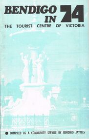
Book - BOOKLET: BENDIGO IN 74
48 paged booklet - ''Bendigo in 74 - The Tourist Centre of Victoria'' - compiled as a community service by Bendigo Jaycees. Comprehensive information about Bendigo and attractions - Index: Accommodation; Additional information; An introduction to Bendigo; Aquarium; Art Gallery; Bendigo Trust; Caravan parks; Dai Gum San; Directory; Eaglehawk Museum; Entertainment; Emergency services; Joss House; Lake Eppalock; National Trust classified buildings; Natural history; Map of Bendigo; Map of city centre; Pottery; Picnic areas; sporting facilities; 'Talking Trams'; Thanks; Tours; Tourist attractions; Victoria Hill; What's on in Bendigo.Bendigo Jaycees. Espress Printers Bendigo.bendigo, tourism, guide 1974, bendigo jaycees, radio 3bo, city family hotel, don murray's hotel motel, cambrian hotel, charlies craft & lifestyle store, powneys authorised newsagent, the bendigo trust, white hills panel works, bendigo pottery, bendigo racecourse, homestead motor inn, peter wade, the persian room, sandhurst trading co. pty. ltd., bendigo air services, bendigo sec, geo. r. innes & sons, cohns, the copper pot, sandhurst travel service. golden hills motel, welcome stranger motel, brian boru hotel, john lindsay's pharmacy & photographic centre, alf morris motors -
 National Vietnam Veterans Museum (NVVM)
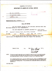
Document, National Service Call-up Notice NS 27 (rev 5/65)
Pro-forma call-up notice issued by Department of Labour and National Service to N E Swainston on 6th April 1971 advising that he has been called up for national service with the Military Forces of the Commonwealth and is to present himself at Engineer's Training Depot, Swan Street, Melbourne on 21st April 1971 at 9.00am. Details are typed in, National Service Registration Office address stamped on in purple. Signed by PH Cook- Secretary, the document advises recipient what to do if he should become ill or injured prior to the set date, and how to claim related expenses.national service - australia, call-up, conscription, swainston collection -
 National Wool Museum
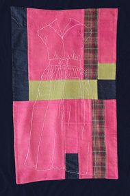
Quilt, Dressed in Memories IV
Winner of "Expressions 2006: The Wool Quilt Prize". Artist statement: 'Dressed in Memories IV is my continued exploration into contemporary quilting by looking back to the history of women, the quilts they made and the memories their work holds. Layered on the wagga of recycled materials is embroidered a dress that my mother made when she was in her teens. This contemporary quilt celebrates women's domestic work through the generations in Australia.'W7183 'Dressed in Memories IV' Detail of 'Dressed in Memories IV' (full photo in W7183textilefibreforumarticle2007.pdf) CV of Michele Eastwood Article 'Stitched and Bound' by Alvena Hall in "Textile Fibre Forum, vol. 21, issue 1, No. 65 2002. Article 'What is a Contemporary Art Quilt?' from "Popular Patchwork, April 2002, England. Article 'Quilt winner dressed for success' from "The Weekly Times", January 3, 2007 Article 'Expressions 2006: The Wool Quilt Prize' from "Textile Fibre Forum" no 85, 2007 Catalogue worksheet page 1 Catalogueworksheet page 2Dressed in Memories IVquilting textile art wagga, eastwood, ms michele, quilting, textile art, wagga -
 Ballarat Tramway Museum
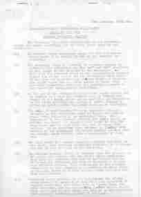
Document - Instruction, State Electricity Commission of Victoria (SECV), "Tramcar Emergency Braking", "Tramcar Braking", Jan. 1965
Significant in being a detailed set of instructions for the tramcar braking system, emergency braking, what to do if things went wrong. Also has questions and answers concerning the braking system. Relates to the driver training system at the time. A later version of that of Reg item 271.Set of six foolscap sheets duplicated, titled "Tramcar Emergency Braking", giving instructions for emergency braking of tramcars for Ballarat and a set of relevant questions and answers, subtitled "Tramcar Braking". Gives description of system, the various means of what to do if the system fails - dated 2th January 1965. The Questions and answers concern the braking system. Sheets stapled twice along the top edge. See Reg Item 261 for an earlier version, 3520 for a 1950 instruction on the same subject and 5370 for an undated version. See Reg Item 5372 for another copy and scanned images of the questions and answers.trams, tramways, ballarat, secv instructions, braking, operations -
 Ballarat Tramway Museum
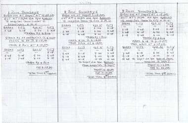
Document - Roster, State Electricity Commission of Victoria (SECV), Rosters Ballarat, 1971?
Yields information about the rosters or the work patterns of the crews in operating the Ballarat tramway towards the time of closure. Has a strong association with the crews themselves as they had to know these on the job.Set of 3 sheets on heat sensitive paper of the roster or timetables of the various tram runs for crews detailing the time they sign on, what services they operate, times, meals, who relieves or takes them, and times finishing, total times and any notes eg change of tram type. Hand written on foolscap size graph paper, with additional notes in ink on each run as needed. Would have allowed the crews to copy into their own note books. Sundays - 1 - 8. 2nd copy added 3/1/2020 See Reg Item 5414 for Weekdays and 5415 for Saturdays.trams, tramways, rosters, timetables, crews, shifts, ballarat