Showing 6697 items
matching river
-
 Sunbury Family History and Heritage Society Inc.
Photograph
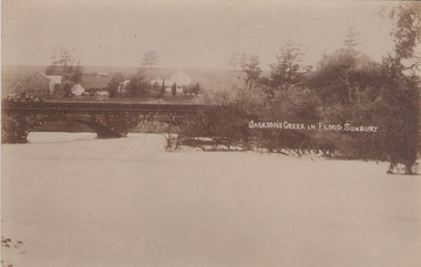
The post card is a record of a time when the Jacksons Creek flooded and the water almost reached the two arches on the Macedon Street Bridge. The Goonawarra Winery buildings can be seen in the back ground.A sepia photograph in post card format of a river in flood with the water almost reaching the two arches on the stone bridge. Farm buildings can be seen in the middle distance.JACKSON'S CREEK IN FLOOD SUNBURYmacedon street bridge, jacksons creek, goonawarra winery -
 Port Fairy Historical Society Museum and Archives
Photograph - Postcard, Moyne bridge
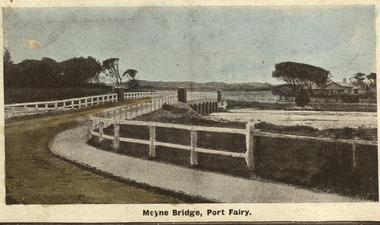
Photograph hand tinted of the Moyne river road bridge taken from Gipps Street showing house on the far bank on the right side taken for use as a PostcardMoyne Bridgemoyne bridge 1910, moyne river, traffic, gipps street -
 Wodonga & District Historical Society Inc
Album - Hume Reservoir Australia Album - Excavations for foundations of spillway, September 1921
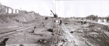
This set of photos is from a leather bound album bearing the inscription "HUME RESERVOIR AUSTRALIA" plus 'The Rt. Hon. L. C. M. S. Amery, P. C., M .P.' all inscribed in gold. It was presented to The Rt. Hon. L. C. M. S. Amery, P. C., M. P, Secretary of State for Dominion Affairs on the occasion of his visit to the Hume Reservoir on 2nd November 1927. This album is of local and national significance as it documents the planning and development of the Hume Reservoir up to 1927. It was the largest water reservoir in the British Empire. The album records the pioneering engineering work that went into its construction.DEPARTMENT OF PUBLIC WORKS, N.S.W. RIVER MURRAY WATERS SCHEME. HUME RESERVOIR. 6. Excavation in progress for foundations of outlet and spillway sections of dam. September 1921.hume reservoir australia, river murray waters scheme, hume weir diagrams, hume plan details -
 Lakes Entrance Historical Society
Photograph - S.S. Gippsland, 1933
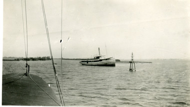
Second copy shows rear view of grounded boat.Black and white photograph showing S S Gippsland aground in Lake King at mouth of Mitchell River, taken from another boat. Lakes Entrance Victoria waterways, ships and shipping, shipwrecks -
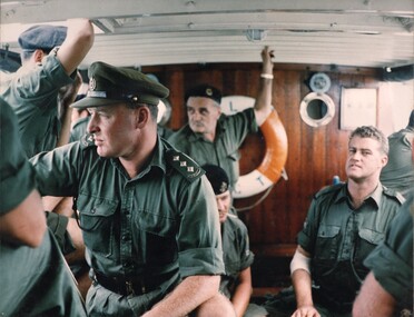 National Vietnam Veterans Museum (NVVM)
Photograph, Gibbons, Denis, L/C Vernon Sturdie
Denis Gibbons (1937 – 2011) Trained with the Australian Army, before travelling to Vietnam in January 1966, Denis stayed with the 1st Australian Task Force in Nui Dat working as a photographer. For almost five years Gibbons toured with nine Australian infantry battalions, posting compelling war images from within many combat zones before being flown out in late November 1970 after sustaining injuries. The images held within the National Vietnam Veterans Museum make up the Gibbons Collection. A coloured photograph of Officers & men on Landing Craft Vernon Sturdie look pensive as they observe the bank of the Mekong River whilst ferrying supplies to the ARVN at Long Binh. photograph, mekong river, arvn, long binh, gibbons collection catalogue, landing craft vernon sturdie, australian soldiers, denis gibbons -
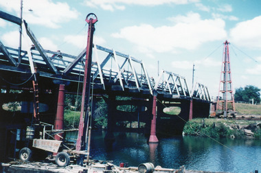 Lakes Entrance Historical Society
Photograph - Bridges, Scarce, Keith, 1955
Colour photograph of the W L Sides and Son drilling rig beside the bridge over the Mitchell River, testing for foundations for the planned new bridge. Bairnsdale Victoriabridges, waterways, machinery -
 Lakes Entrance Historical Society
Book, Smyth Chris, Baltuiks Isabel, Roberts Lorelle, Roberts Maurice, Stooping Stones a Guide to Mallacoota and District, 1986
Description guide to Mallacoota Victoria and the surrounding district of far East Gippsland including Genoa Gipsy Point and Betka River illustrated with sketch maps photographs and sketches.township -
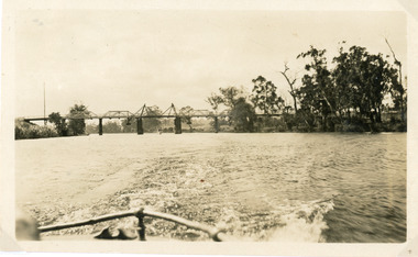 Lakes Entrance Historical Society
Photograph - Bridges, 1925
Photo taken same year Swan Reach bridge collapsed 16 November 1925Black and white photograph of the lifting bridge over the Tambo River taken from the stern of a boat. A tourist launch under the bridge in distance. Swan Reach Victoriabridges, waterways -
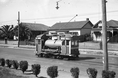 Melbourne Tram Museum
Negative, Wal Jack, 15/03/1945 12:00:00 AM
Black and white negative, by Wal Jack, of Scrubber 8 in Maribyrnong Road. Wal's album notes that the photo is near the River terminus and dated 15-3-1945.trams, tramways, maribyrnong rd, scrubber tram, work trams, tram 8 -
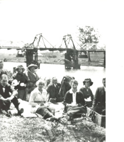 Lakes Entrance Historical Society
Photograph, Myrtle Grant, 1920 c
Myrtle is in centre with white blouseBlack and white photograph showing Myrtle Grant and eight people having a picnic on bank of Tambo River with original bascule bridge in background at Swan Reach Victoriagenealogy, families -
Lakes Entrance Historical Society
Book, Rogers, L. C, 1982
Day-to-day life in the Snowy River high country, East Gippsland, and across the border. The author also tells of his travels and lifestyle change in later life.settlers, alpine region -
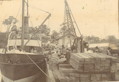 Lakes Entrance Historical Society
Photograph - SS Glenelg c1900, 1900 c
Steamer believed to be SS Glenelg owned by G A and J Carpenter Ellerker and Co and Jackson 1898Sepia toned photograph mounted on heavy cardboard showing an unnamed steamer being either loaded or unloaded with timber at busy Mitchell River wharf Bairnsdale Victoriaboats and boating, gippsland lakes, jetties, wharfs -
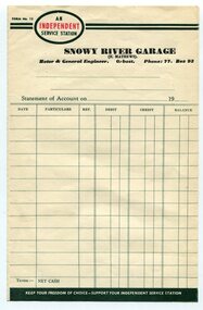 Orbost & District Historical Society
Certificate
Frank Matthews was a well-respected garage owner and mechanic in Orbost for many years. Evidence of ownership and existence of the Snowy River Garage, Orbost Rectangular paper, printed in black ink, the word INDEPENDENT is printed in red inside an oval shape. An INDEPENDENT Service Station Snowy River Garage (F Matthews) Motor & General Engineer, Orbost Ph. 77 Box 93snowy river garage, orbost, frank matthews -
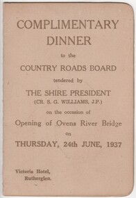 Rutherglen Historical Society
Menu and Toast List, Complimentary Dinner to the Country Roads Board, 1937 (exact)
Dinner was held at the Victoria Hotel, Rutherglen. The Shire President was Cr. S.G. Williams, J.P.Small card folder, with menu and toast list"Complimentary Dinner to the Country Roads Board tendered by the Shire President on the occasion of the opening of the Ovens River Bridge on 24th June, 1937"country roads board, ovens river bridge, opening celebration -
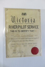 Seaworks Maritime Museum
Certificate, 12/02/1912
A4 sized certificate with a black border and red seal. "Victoria/ River Pilot Service/ This is to certify that/ Alba Cunnigham/ is duly qualified and competent to take charge and navigate all/ craft plying upon the Upper Yarra River Melbourne/ Licence issued under the Marine Board/ This twelfth day of February 1912/ Port Officer" written with pencil on the back "7.06" -
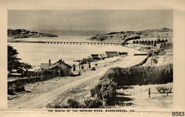 Flagstaff Hill Maritime Museum and Village
Postcard - Postcard Folder - scenes, George Rose, Rose Stereographic Company, Rose Series Picturesque Views of Warrnambool Australia [Warrnambool], 1880-1942
This postcard folder contains lithographs of photographs taken locally by Georg Rose between 1880 and 1942. He reproduced them at his company's premises, the Rose Stereographic Company at Armadale, Victoria. The postcard folder was purchased as a Warrnambool souvenir by the donor's parents around 1945 to 1950. Interestingly, the city on the cover is printed as "Warrambool", which is a location in New South Wales, but the postcards within all have the locations and text of Warrnambool. The photographs include the 'new' concrete bridge, built in 1922 to replace the original bridge, built in 1872. The boathouses belonging to Proudfoots and to Flett/Fanny Nelson are also pictured on the Hopkins River mouth. The twelve photographs included locations connected to other items in our Collection. The photographs are titled: - b. The Avenue and War Memorial. Warrnambool. Vic. c. The Blow-hole. Thunder Point. Warrnambool. Vic. d. Botanical Gardens. Warrnambool. Vic. e. Eagle Rock. Warrnambool. Vic. f. The New Concrete Bridge and Breakwater. Warrnambool. Vic. g. Liebig Street. Warrnambool. Vic. h. Looking to Thunder Point. Warrnambool. Vic. i. The Beach. Warrnambool. Vic. j. Hopkins Falls. Warrnambool. Vic. k. Shelly Beach. Warrnambool. Vic. l. The Mouth of the Hopkins River. Warrnambool. Vic. m. Panorama of Warrnambool. Vic. [Kepler Street towards Presbyterian Church on Spence St] George Rose, 1861-1942: - famous for his Late 19th and early 20th century photography. He was born in Clunes, Victoria, and was in his 20th year when he founded Rose Stereograph Company in 1880. He took the opportunity of a popular trend of the times to produce stereographs, pairs of almost duplicate photographs which appeared to be in 3D when viewed in a handheld stereo viewer. By the 1920s these lost their popularity, so he used his photographic skills to produce cards and postcards of scenes and people. The photographs in this postcard folder were taken between 1880 and 1942 by the renowned Victorian photographer George Rose. The locations match photographs and postcards in our collection that were taken at different times. A comparison between them shows the changes over time in the land and bay, the buildings and other structures, transportation and even the fashions of the times, building the story of our local history.This copy of a postcard folder has a blue-grey textured rectangular card cover with a sketch of a rose on the front along with the name of the postcard series. the location of the series' focus, the producer's details and lines for adding an address. The folded cover contains a long, concertinaed page with six titled photographs on each side, totalling twelve in all. Interestingly, the cover has the location name of "Warrambool", a place in NSW, instead of Warrnambool, the location of all of the photographs inside. The folder contains scenes from Warrnambool and nearby popular areas including Lady Bay, Port of Warrnambool, Warrnambool Breakwater, Viaduct, Merri River Footbridge, the Hopkins River Mouth, with Proudfoot’s and the Fanny Nelson/Flett boathouses. The cover has a sketch of a rose and inscriptions. The photographs for the lithographs were taken prior between 1880 and 1942 by well-known Victorian photographer, George Rose, Rose Stereograph Company of Armadale, Victoria.Image: [Rose with rosebud and leaves] Printed: "Rose Series / Picturesque Views of / WARRAMBOOL / AUSTRALIA" [correct spelling is WARRNAMBOOL] "PUBLISHED BY / ROSE STEREOGRAPH CO / ARMADALE. VIC." Printed lines (3) for an address. Printed rectangle [ ] for attaching a stamp.flagstaff hill maritime museum and village, great ocean road, shipwreck coast, warrnambool, flagstaff hill, flagstaff hill maritime museum, flagstaff hill maritime village, warramble, postcard, postcard folder, warrnambool scenes, picturesque views of warrnambool, picturesque views of warramble, lady bay, port of warrnambool, breakwater, warrnambool breakwater, viaduct, merri river footbridge, merri river suspension bridge, suspension footbridge, merri river mouth, hopkins river mouth, proudfoot's, fanny nelson, nelson's boatsheds, nelson's boathouse, boathouse, hopkins river boathouses, flett's boathouse, flett, george rose, image of a rose, rose series, rose stereograph co, rose stereographic company, lighograph, armadale victoria, lady bay beach, beach scene, lower light, concrete footbridge, 1922 footbridge, viaduct road, rose postcard, new concrete bridge, 1945, 1890, 1922, small footbridge, 1872 footbridge, 1872, merri river estuary, stingray bay, postcards -
Federation University Historical Collection
Book, Northern Territory of South Australia Report Resulting from the Explorations by the Government Geologist, 1906, 1906
Pale blue soft covered geological and general report. It includes a chapter of Bathurst Island and Melville Island, Primitive Methhods of Chinese Mining, Early Days of Mining in the Northern Territory Images include sandbank at low tide, Douglas River, Granite at Union Hill, Night Cliff, East Point, union hill, zapopan gold mine Brook's Creek, Blow Gold Mine Yam Creek, Daly River Copper Mine, Mount Ellison Copper Mine, Point Charles Lighthouse, Blacks Camp near Point Charles Lighthouse, The Venture Stranded on a Daly River Sandbank, Hyland Bay Natives, Boabab Trees at Blunder Bay, The Wai Hoi, Mouth of Fitzmaurice River, Point Blaze Natives, Fort Hill and Old Gulnare Jetty Port Darwin, Large Anthill, Daly RIver Natives, Wargie Natives, L.C.E. Gee, H.Y.L. Brown, H. Basedow. F.J. Williamson, Aboriginal crew (Pedro, Peter, Tobatchie, Bubs, Loman), Henry Roberts, Schollert's Grave It also includes a large folder Geological Map of the North-Western District Northern Territory of South Australia. northern territory of south australia, geology, l. o'loughlin, douglas river, bathurst island, melville island, apsley straight, chinese, aboriginal -
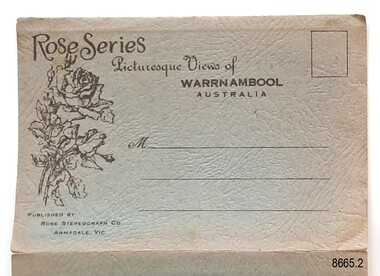 Flagstaff Hill Maritime Museum and Village
Postcard - Postcard Folder, scenes, George Rose, Rose Stereographic Company, Rose Series, Picturesque Views of Warrnambool Australia, 1880-1942
GEORGE ROSE 1861-1942: - George Rose was a well-known Victorian photographer, famous for his late 19th and early 20th century photography. He was born in Clunes, Victoria, and was in his 20th year when he founded Rose Stereograph Company in 1880. He took the opportunity of a popular trend of the times to produce stereographs, pairs of almost duplicate photographs that appeared in 3D when viewed in a handheld stereo viewer. By the 1920s, these lost their popularity, so he used his photographic skills to produce cards and postcards of scenes and people. The twelve photographs in the Rose postcard folders include locations connected to other items in our Collection, including the Valentine postcard folder in this set. The photographs are titled: - . The Avenue and War Memorial. Warrnambool. Vic. . The Blow-hole. Thunder Point. Warrnambool. Vic. . Botanical Gardens. Warrnambool. Vic. . Eagle Rock. Warrnambool. Vic. . The New Concrete Bridge and Breakwater. Warrnambool. Vic. . Liebig Street. Warrnambool. Vic. . Looking to Thunder Point. Warrnambool. Vic. . The Beach. Warrnambool. Vic. . Hopkins Falls. Warrnambool. Vic. . Shelly Beach. Warrnambool. Vic. . The Mouth of the Hopkins River. Warrnambool. Vic. . Panorama of Warrnambool, Vic. [Kepler Street towards Presbyterian Church on Spence St] This postcard folder shows scenes and places of interest in and around Warrnambool. The George Rose postcard folders in this set were produced in Victoria and include pictures taken by the renowned photographer between 1880 and 1942. Other postcards in our collection have photographs of the same or similar locations at different periods in time. Each postcard records a moment in history and is significant as a way to compare and show the changes in the local environment and community, building a story of the local history. The images record changes in the coastline, land, bay, buildings and other structures, roads, transportation and even the fashions of the times. This copy folder is one of a set of three. This folder has a green-grey textured rectangular card cover with a sketch of a rose on the front. The cover also contains the name of the postcard series, the location of the series' focus, the producer's details, and lines for adding an address. The folded cover contains a long, concertinaed page with six titled photographs on each side, totalling twelve. The folder contains scenes from Warrnambool and nearby popular areas, including Lady Bay, the Port of Warrnambool, the Warrnambool Breakwater, the Viaduct, the Merri River Footbridge, the Hopkins River Mouth, and Proudfoot’s and the Fanny Nelson/Flett boathouses. The cover has a sketch of a rose and inscriptions. The lithograph photographs were taken between 1880 and 1942 by well-known Victorian photographer George Rose, Rose Stereograph Company of Armadale, Victoria.Image: [Rose with rosebud and leaves] Printed: "Rose Series / Picturesque Views of / WARRNAMBOOL / AUSTRALIA" "PUBLISHED BY / ROSE STEREOGRAPH CO / ARMADALE. VIC."flagstaff hill maritime museum and village, great ocean road, shipwreck coast, warrnambool, flagstaff hill, flagstaff hill maritime museum, flagstaff hill maritime village, warramble, postcard, postcard folder, warrnambool scenes, picturesque views of warrnambool, lady bay, port of warrnambool, breakwater, warrnambool breakwater, viaduct, merri river footbridge, merri river suspension bridge, suspension footbridge, merri river mouth, hopkins river mouth, proudfoot's, fanny nelson, nelson's boatsheds, nelson's boathouse, boathouse, hopkins river boathouses, flett's boathouse, flett, george rose, image of a rose, rose series, rose stereograph co, rose stereographic company, lighograph, armadale victoria, lady bay beach, beach scene, lower light, concrete footbridge, 1922 footbridge, viaduct road, rose postcard, new concrete bridge, 1945, 1890, 1922, small footbridge, 1872 footbridge, 1872, merri river estuary, stingray bay, postcards, green-grey postcard folder, shipwrecked coast, maritime museum, souvenir, warrnambool local scenes, photography, local history, tourism, photographs, visitors, travel, scenes, mid-20th century, 1940s, 1950s, concertina fold, z-fold, 1880s, collection, correspondence, rose stereograph co armadale, victorian photographer, soldiers’ memorial, hopkins river, the cliffs at shelly beach, the road to sandy beach, pier, botanic gardens, post office, municipal buildings, merri river, proudfoot’s -
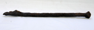 Orbost & District Historical Society
bridge spike
This spike came from the old Brodribb River bridge which is about 9.6 kilometres from Orbost. The Brodribb River joins the Snowy River north of Marlo. In 1906, a bridge replaced the punt over the Brodribb River, improving communication with Orbost. It was eventually replaced by a reinforced concrete bridge built by the Road Construction Authority in 1989 where the Princes Highway passes over the Brodribb RiverThis item belongs to a significant local structure which has been replaced.A very rusty iron bridge spike from the old Brodribb Bridge.brodribb-river bridge-spike -
Federation University Historical Collection
Plan, R. Underwood, Shire of Winchelsea, 1952, 10/10/1952
Copy of a plan of the Shire of Winchelsea including Lake Wollard, Wormbete, angahook, boonah, Barwon Downs, Kaanglang, St Gerge River, Cumberland Creek, Stony Creek, Bambra, Wensleydale, yan Yan Gurt, Tutegong, Mirnee, Karngun, whoorel, Birregurra, Barwon River, Thompson's Creek, Bass Straight. Mt Defiance, Mt St George, Loutit Bay, Airey's Inlet, Salt Creek, Mathew's Creek.winchelsea, lake wollard, wormbete, angahook, boonah, barwon downs, kaanglang, st george river, cumberland creek, stony creek, bambra, wensleydale, yan yan gurt, tutegong, mirnee, karngun, whoorel, birregurra, barwon river, thompson's creek, bass straight. mt defiance, mt st george, loutit bay, airey's inlet, salt creek, mathew's creek, r. underwood, why river, point sturt, barwon downs, forest -
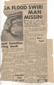 Ballarat Tramway Museum
Newspaper, Herald Sun, "Barwon fight", 19/06/1952 12:00:00 AM
Newspaper Clipping from the Melbourne "The Sun", dated 19/6/1952 about widespread flooding in Victoria and Wagga and on the right hand side of the clipping the Barwon River Geelong titled "Barwon fight". Notes the flooding over the Barwon River which caused suspension of the tram services. Contained originally within Reg Item 5623 at the front of this note book. For items see btm5623 loose items list.pdf.geelong, flooding -
 Kew Historical Society Inc
Photograph - Yarra River, Studley Park, 1924
Henry Beater Christian (1886-1962) , was a descendant of one of the earliest settler families in Kew. Employed at the Kew Asylum as a 'public servant', he was a skilled amateur photographer, photographing numerous scenes in Kew and on his travels around Victoria. The majority of his photographs date from 1916 to 1929. His finest photographs are housed in two photograph albums. Digital copy of a photograph from page 7 of the 47-page photograph album containing 261 gelatinous silver images, loaned by Diane Washfold with permission given to digitise and hold a copy in our collection. This is a photograph of the Yarra River at Kew in the vicinity of one of the boat sheds. On the right river bank is a small ferry or launch that carried passengers from Melbourne to Heidelberg, stopping at key locations en route. "Studley Park / Kew"henry beater christian (1886-1962), landscape photography, kew (vic.) — yarra river, christian-washfold collection, photograph albums, yarra ferries, boat houses, boat sheds -
 Kew Historical Society Inc
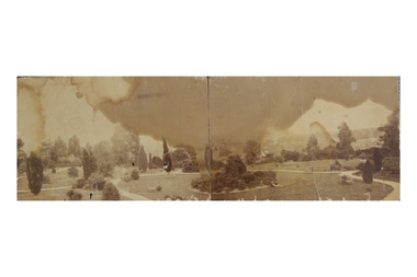
Photograph, Garden of 'Rockingham', Kew, c.1870
Built by John Bournane, Rockingham had a number of occupants before the newspaper magnate David Syme purchased it in 1902. The house in the 1860s and ‘70s was comprised of nine rooms, and was surrounded by a veranda on the front and sides. It was approached from the Kew road by the curve in front of the Hon. S.G. Henty’s mansion of ‘Findon’.In 1955, the Syme family sold Rockingham to the Red Cross Society to be used as a convalescent home for returned servicemen. The house was sold, demolished, and the land subdivided in 1966.An early panoramic photograph of an early Kew mansion (now demolished), dating from the 1870s.A rare, panoramic photograph (c.1870) of the garden of ‘Rockingham’, during the occupation of the house by W. Gardiner Esq. Rockingham was located beside and above the Barkers Road cutting. The view of the garden in the photograph is of the terraces leading down to the Yarra River. At the time the photograph was taken, the property covered an area of “…nine acres of beautifully laid-out grounds, interspersed with numerous terraces leading down the sloping bank of the river”.rockingham, david syme, kew -
 Bendigo Military Museum
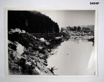
Photograph - PHOTOGRAPH, WAMPO BRIDGE, C1943-1948
REFER TO CAT 5445.2Photograph black and white. River, jungle covered hills. In the centre of the photo is a rail trestle bridge set against the steep hillside. The trestle bridge is made from timber On the rear of the photograph in ink. - 122326 WAMPO BRIDGE THAILAND- BURMARAILWAYww2, pow, burma railway -
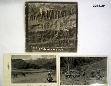 Bendigo Military Museum
Photograph - PHOTOGRAPHS, BURMA, 26th Nov 1944
Items in the collection re Ian McLeod RWAFF, refer Cat No 2262.2.1) Aerial Sepia photograph countryside Burma. .2) Black and White photo Burma river, mountains and "kumi" natives. .3) Black and White photograph Burmese Jungle..1) “4191. 26 Nov. 44” .2) “Burmese Campaign 1944” .3) “Burmese Jungle 1944”burma, aerial, photographs -
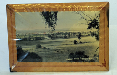 Orbost & District Historical Society
framed photograph, Orbost From "Grandview", mid 20th century
This photograph was taken from Grandview overlooking the Orbost flats.A black/white photograph in a frame. The frame has a stand. The frame is card padded over a metal frame. It is covered in plastic. The photograph is of the Orbost flats with the river and the town in the background.in white - "Orbost From "Grandview"grandview orbost-flats photograph -
Port Melbourne Historical & Preservation Society
Photograph - Aerial view Maribyrnong and Yarra rivers and Coode Island, c. 1976
Donated to City of Port Melbourne by Councillor Russell GRIFFITHS.Aerial photograph taken from above junction of Yarra and Maribyrnong rivers showing oil and chemical storage farm at Coode Island and four container vessels at Swanson Dock.transport - shipping, piers and wharves - miscellaneous, swanson dock -
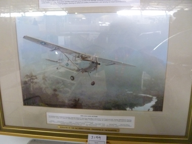 National Vietnam Veterans Museum (NVVM)
Print, Bird Dog Over Vietnam
Gold framed bone matt board colour print of a Cessna Bird Dog single engine light aircraft flying over jungle with mountains in the background and river belowForward Air Controllers in Vietnam 1965 - 1971. Bird Dog Over Vietnam. Donated by the FAC Association - presented by the RAAFVVAcessna o.1 bird dog, framed print -
Port Melbourne Historical & Preservation Society
Photograph - Nairana ashore at Port Melbourne, Taroona, inner west, Station Pier, Glen Stuart, 1950s
One of nine photographs taken of various ships at Port Melbourne and river berths in the early 1950s: Nairana ashore at Port Melbourne, Taroona inner west Station Pierpiers and wharves - station pier, transport - shipping, taroona, nairana -
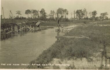 Bendigo Historical Society Inc.
Postcard - ACC LOCK COLLECTION: THE LYS NEAR SAILLY AFTER GERMAN OFFENSIVE, POSTCARD, 1914-1918
Postcard, WW1, B&W image of the timber remains of a bridge over the river Lys near Sailly after a German offensive. Possibly a footbridge. Copy y 18postcard, postcard, ww1, sailly, german offensive, bridge