Showing 173680 items
matching street
-
 Stawell Historical Society Inc
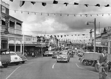
Photograph, Main Street Stawell looking West with street decorations April 7 1955
Main Street Stawell April 7 1955 looking West with street decoration . Oliver's Bull and Mouth Hotel on Left. Vehicles on roadstawell businesses streetscape -
 Stawell Historical Society Inc
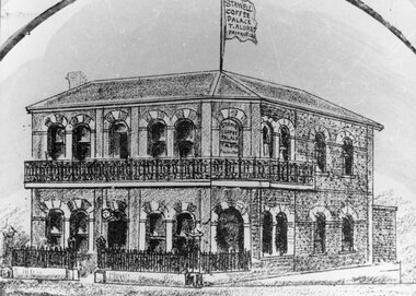
Drawing, Coffee Palace, formerly Castlemaine Hotel owned by Mr T Aldred on the corner of Main Street Stawell & Victoria Street fromthe P.C. News Supplement 1888 - Sketch
Coffee Palace T. Aldred formerly Castlemaine Hotel corner of Main Street and Victoria Street from P.C. News Supplement 1888stawell businesses -
 Melbourne Tram Museum
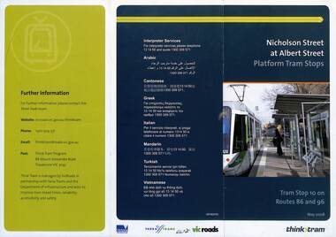
Pamphlet, VicRoads, "Nicholson Street at Albert Street Platform Tram Stops", May 2008
Pamphlet - "Nicholson Street at Albert Street Platform Tram Stops" - includes a plan of the proposed work, timing, and benefits of the installation. May 2008.Yields information about the installation of super stops at Nicholson and Albert Sts.Pamphlet - 3 fold DL full colourtrams, tramways, super stops, platform stops, planning, construction, nicholson st, albert st -
 Eltham District Historical Society Inc
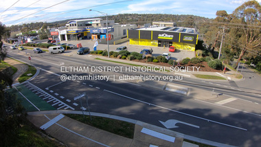
Photograph, Peter Pidgeon, Shops at corner of Bolton Street and Brougham Street, Eltham, 2 Aug. 2022
View looking east from Bolton Street near Brougham Street, Eltham taken from PETStock looking over the industrial area of ElthamBorn Digitaleltham, bolton steet, industry, petstock eltham central, autobarn, shops, brougham street, eltham ridge -
 Eltham District Historical Society Inc
Slide, Looking north along Bolton Street at intersection with Godalmin Street;, Eltham, 18 July 1972, 1972
Reconstruction works by Eltham Shire Council, Bolton Street, Eltham, 18 July 1972 House visible is present day No. 1 Godalmin Street35 mm colour positive transparency Mount - Agfacolor Service (Blue)bolton steet, eltham, eltham shire council, godalmin street, infrastructure, road construction -
 Eltham District Historical Society Inc
Slide, Looking north along Bolton Street at intersection with Godalmin Street;, Eltham, 18 July 1972, 1972
Reconstruction works by Eltham Shire Council, Bolton Street, Eltham, 18 July 1972 House visible is present day No. 1 Godalmin StreetDigital panorama created from two 35 mm colour positive transparency Mount - Agfacolor Service (Blue)bolton steet, eltham, eltham shire council, godalmin street, infrastructure, road construction -
 Eltham District Historical Society Inc
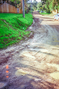
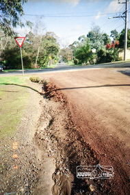
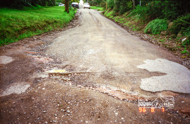
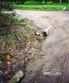
Photograph, Road surface conditions around Eltham: Looking east along Franklin Street from intersection with Bible Street, 7 Aug 1996, 1996
Shows sections of Franklin, John and Napoleon streets were still unmade as of late 1996 and the condition of those roads with potholes at the intersections with Bible Street.Reflects on the changing nature of the local street-scape and housesRoll of 35mm colour negative film, 7 stripsKodak Gold 100-5eltham, napoleon street, bible street, franklin street, john street -
 Eltham District Historical Society Inc
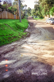
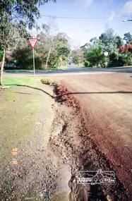
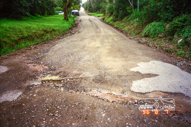
Photograph, Road surface conditions around Eltham: Looking west along Franklin Street at intersection with Bible Street, 7 Aug 1996, 1996
Shows sections of Franklin, John and Napoleon streets were still unmade as of late 1996 and the condition of those roads with potholes at the intersections with Bible Street.Reflects on the changing nature of the local street-scape and housesRoll of 35mm colour negative film, 7 stripsKodak Gold 100-5eltham, napoleon street, bible street, franklin street, john street -
 Eltham District Historical Society Inc
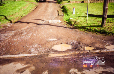
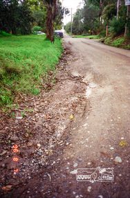
Photograph, Road surface conditions around Eltham: Looking west along John Street at the intersection with Bible Street, 7 Aug 1996, 1996
Shows sections of Franklin, John and Napoleon streets were still unmade as of late 1996 and the condition of those roads with potholes at the intersections with Bible Street.Reflects on the changing nature of the local street-scape and housesRoll of 35mm colour negative film, 7 stripsKodak Gold 100-5eltham, napoleon street, bible street, franklin street, john street -
 Eltham District Historical Society Inc
Photograph, Road surface conditions around Eltham: Looking east along John Street at the intersection with Bible Street, 7 Aug 1996, 1996
Shows sections of Franklin, John and Napoleon streets were still unmade as of late 1996 and the condition of those roads with potholes at the intersections with Bible Street.Reflects on the changing nature of the local street-scape and housesRoll of 35mm colour negative film, 7 stripsKodak Gold 100-5eltham, napoleon street, bible street, franklin street, john street -
 Eltham District Historical Society Inc
Photograph, Road surface conditions around Eltham: Napoleon Street looking east from intersection with Bible Street, 7 Aug 1996, 1996
Shows sections of Franklin, John and Napoleon streets were still unmade as of late 1996 and the condition of those roads with potholes at the intersections with Bible Street.Reflects on the changing nature of the local street-scape and housesRoll of 35mm colour negative film, 7 stripsKodak Gold 100-5eltham, napoleon street, bible street, franklin street, john street -
 Eltham District Historical Society Inc
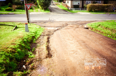
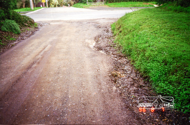
Photograph, Road surface conditions around Eltham: Napoleon Street looking west across Bible Street, 7 Aug 1996, 1996
Shows sections of Franklin, John and Napoleon streets were still unmade as of late 1996 and the condition of those roads with potholes at the intersections with Bible Street.Reflects on the changing nature of the local street-scape and housesRoll of 35mm colour negative film, 7 stripsKodak Gold 100-5eltham, napoleon street, bible street, franklin street, john street -
 Eltham District Historical Society Inc
Photograph, Road surface conditions around Eltham: Napoleon Street at Bible Street, Eltham, looking south-east, 7 Aug 1996, 1996
Shows sections of Franklin, John and Napoleon streets were still unmade as of late 1996 and the condition of those roads with potholes at the intersections with Bible Street.Reflects on the changing nature of the local street-scape and housesRoll of 35mm colour negative film, 7 stripsKodak Gold 100-5eltham, napoleon street, bible street, franklin street, john street -
 Stawell Historical Society Inc
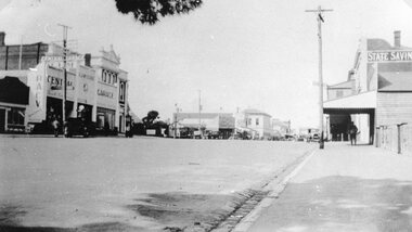
Photograph, Main Street Stawell looking East from St Georges Street with McClure's Garage, Post Office & the State Savings Bank on right 1930
Main Street Stawell McClure's garage Post Office State Savings Bank on Right. 1930 looking East from St Georges Streetstawell businesses streetscape -
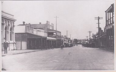
 Stawell Historical Society Inc
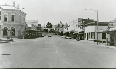
Photograph, Main Street Stawell looking East from west of Wimmera Street
Stawell Main Street looking East from west of Wimmera Street. Post office on left Post Office Arcade on right. Vehicles in distance.stawell streetscape -
 Stawell Historical Society Inc
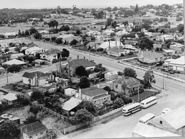
Photograph, Panorama of Stawell from the top of St. Matthew’s Spire with the Childe Street and Wimmera Street intersection on the right
Panorama of Stawell from the top of St. Matthew’s Spire. Childe Street and Wimmera Street intersection at right of photograph. Kings Buses in right corner.stawell, streetscape -
 Ballarat Tramway Museum
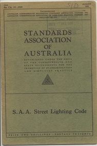
Book, Australian Standards Association, "SAA Street Lighting Code", 1939
Book - 28 pages + slight Green covers, side stapled, issued by the Australian Standards Association, "SAA Street Lighting Code" August 1939, CAA. 19-1939 providing standards for the lighting of intersections, streets, location and mounting of lights, and the type of units.On top right hand corner has stamp of the "SEC Ballarat Branch stamp, and dated 8. Dec. 1939" and letters S/D in pencil.trams, tramways, lights, standards -
 Lakes Entrance Historical Society
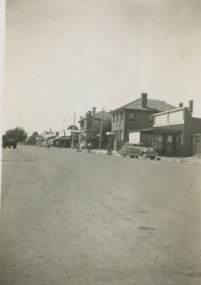
Photograph - Nicholson street Orbost Victoria, 1950 c
Small black and white photograph showing main street Nicholson St with two double story buildings on right one being state Savings Bank and seven shops, car on right 1950 vintage buildings on east side of street Orbost VictoriaOrbost transport, banking, businesses -
 Lakes Entrance Historical Society
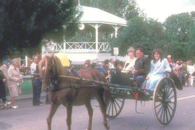
Photograph - street parade at Bairnsdale Victoria, K Scarce, 1984
Colour photograph showing two girls wearing winners sashes with driver in horse drawn vehicle passing rotunda during street parade at Bairnsdale Victoria. Also colour photograph of two men on horseback passing rotunda during street parade Bairnsdaletownship, parade, public events -
 Ringwood and District Historical Society
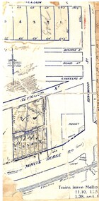
Map, Partially trimmed copy of a retail and residential auction advertisement, Ringwood, Vic. - 1926
One of 3 unrelated land subdivision maps on cardboard backing. Numbered allotments on Nelson Street, Seymour Street and Whitehorse Road, Ringwood.W.J. Bonwick, Licensed Surveyor, Phone WU4830. Location map also includes Bourke Street, Bond Street, Charter Street, Ringwood Street, and Shops and Market sites in Ringwood. -
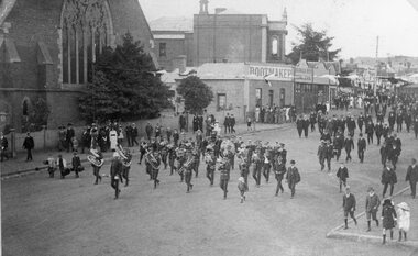 Stawell Historical Society Inc
Photograph, Street Parade in Main Street led by Stawell Band near Holy Trinity Church
Main Street. Street Parade led by Stawell Band near Holy Trinity Church. Bootmaker Mr Webster. Barker Bros Grocers. Town Hall. stawell -
 Rutherglen Historical Society
Image, c1930
Building on left of street, in the foreground was originally the Bank of Victoria, and is now the NAB. Further along on that side is the Rutherglen Hotel, now Poachers Paradise. In the foreground on the right, is the Star Hotel.One of three black and white photographs, mounted on orange paper. This one is of Main Street, looking west from the corner of High Street. Written on mount: "Looking west from cnr High & Main St. Circa 1930's"main street, bank of victoria, nab, rutherglen hotel, poachers paradise hotel, star hotel, hotels, banks -
 Whitehorse Historical Society Inc.
Article, 22 Elder Street, Blackburn, 2017
A Blackburn home at 22 Elder Street, believed to be the first constructed in the street, will be auctioned by Woodards. The block originally sold in 1927 on which the article states eight thousand five hundred pounds which would be a typo and should read eight hundred and fifty pounds.elder street, blackburn no. 22, woodards -
 Linton and District Historical Society Inc
Photograph, Preston House and Shop, Sussex Street, Linton, 1988
The white corner building was formerly a fruit and vegetable shop which was run by various generations of the Preston family, the last of whom was George Preston. The shop closed in the 1970s and this photo taken in 1988 shows it without its original verandah. Dean Hart afterwards purchased the weatherboard house as a residence and demolished the shop building on the corner.Colour photograph showing a green double-fronted weatherboard house in Sussex Street, Linton. The house has a chimney, pitched roof and a small porch, and a picket fence across the front. A smaller, white-painted building fronts the footpath on the corner of Sussex and Gillespie Streets.buildings, houses, shops, preston's shop, george preston, dean hart -
 Eltham District Historical Society Inc
Photograph, Looking north along Main Road from Diamond Street Railway Crossing at intersection with Cecil Street, Eltham, February 1968, Feb 1968
Cecil Street to the right.In February 1968 an unknown person took a series of photos from the Eltham Hotel at Pitt Street heading north along Main Road through the shopping centre to just north of Elsa Court covering the length of the section of Main Road which was duplicated shortly thereafter. Shows the condition and environment of the streesscape of Main Road, Eltham immediately prior to the duplication between Pitt Street and Elsa Court through the shopping centre. Also shows a number of shops and businesses that operated at that time.Black and white photographduplication, eltham, main road, cecil street, diamond street, railway line -
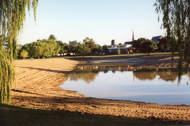 Stawell Historical Society Inc
Photograph, Cato Lake looking from Sloane Street -- Coloured
Cato Lake view from Sloane Street. This photo is one of three showing Stawell Council Works deepening Cato Lake in February c 2002. Tracks from a tractor can be seen all round the lake. Willows branches hang either side of the view with trees along the horizon. The Presbyterian Church tower, Senior Citizen room and Anglican Church can be seen amongst the trees in the background.Coloured photograph of Cato Lake. The view is from Sloane Street and the lake was in the process of being lowered for the deepening of the lake by Shire Council Works. Tractor tracks can be seen all round the lake. Willows hang either side of the view with trees along the horizon. The Presbyterian Church tower in the background near the Senior Citizen room and Anglican Church to the right.Date on back of photo in biro 12.2.2002.stawell