Showing 23714 items
matching creeks
-
 Stawell Historical Society Inc
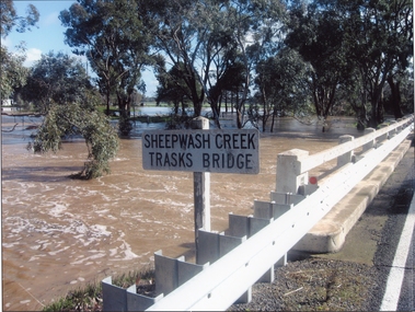
Photograph, Trasks Bridge at Sheepwash Creek at Campbells Bridge in flood 2011
Trasks Bridge Sheepwash Creek at Campbells Bridge in flood 2011.stawell shire -
 Falls Creek Historical Society
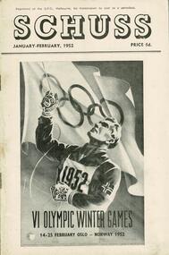
Journal - Schuss Vol. 18. No. 1 January - February 1952
Schuss was advertised as Victoria’s Official Ski Journal It was issued monthly from 1935 to 1961 except during the war when summer issues covered two months. This continued after the war, but it averaged 10 issues annually over its 25 year life. Schuss was published by the Ski Club of Victoria which had a membership of 38 Ski Clubs and demanded to be recognised as the prime authority on skiing in the state. The other 30 ski clubs with 85% of the members disagreed and the politics of skiing became heated. These clubs formed the Federation of Victorian Ski Clubs with their own journal, Ski Horizon. With the establishment of the Victorian Ski Association, Ski-Horizon published its last issue in Nov - Dec. 1955 and the role of the official journal was fully taken over by “Schuss”. This item is significant because it contains stories, images and information documenting the development of the ski industry in Victoria.The journal features stories and events chronicling developments in Victoria and internationally. Items related to the Falls Creek Area in this issue include:- Cover - Image acknowledging the Australian team in the Oslo Winter Olympics Page 31 - TRANSPORT TO FALLS CREEK - Following press reports in recent months regarding curtailment of the work of the State Electricity Commission on Bogong High Plains, there will be no snow clearing on the road above Howman's Gap next winter, and possibly no snow clearing at all. Traffic will not be permitted to proceed where no clearing is being carried out. Apart from this, it is hoped that it will not be necessary to curtail any further the general arrangements in force last winter. During this summer the road will be closed to visitors generally, but arrangements will be made for working parties at ski huts to proceed to or from Falls Creek between 8 a.m. and 5 p.m. on Saturdays and Sundays only, provided that prior arrangements have been made.winter olympics 1952, road access to falls creek 1952 -
 Stawell Historical Society Inc
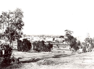
Photograph, Pleasant Creek Stawell from Church Hill with the Shire Hall at left under construction & the Pleasant Creek Court House visible at centre 1866
Pleasant Creek Stawell from Church Hill. Shire Hall at left under construction. Pleasant Creek Court House visible at centre. Part of a collection of Photographs by Mr. O.G. Armstrong as commissioned by the Shire of Stawell for the Inter-colonial and Paris Exhibition in Melbourne in 1866.stawell -
 Ringwood and District Historical Society
Photograph, Ringwood, Mullum Mullum Creek, east side. Warrandyte Road Bridge. 1986
Written on backing sheet, "Bridge, Mullum Rd. Completed May 1987." Writing on back of photograph reads, "Aug., 1986. Ringwood, Mullum Mullum Creek, east side. Warrandyte Road Bridge". -
 Ringwood and District Historical Society
Photographs, 1979-80 MMBW pipe line project at Hubbard Reserve, North Ringwood � View towards Debbie Place
Part of a 43-photo record of the MMBW�s engineering feat in drilling a 12 inch pipe line up to 40 feet deep through rock hardened by volcanic action associated with geological fault that occurs along the line. The work took place from October 1979 to May 1980 on the southern boundary of Hubbard Reserve, North Ringwood. The collection was presented to the Ringwood Historical Research Group by J Clarke on 9th June 1980.E561 N15 3 March 1980 A43 View towards Debbie Place, showing 2 swivel cranes at shafts, timber of manhole in creek, the tracked drill rig and its compressor caravan. -
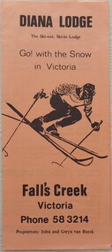 Falls Creek Historical Society
Booklet - Diana Lodge, c1967 - 1975
Diana Lodge was built and operated by Kevin Shoebridge as a family lodge in the 1950s and it has grown and evolved over 60 years to become Diana Alpine Lodge. After Mr. Shoebridge moved to Wodonga he leased Diana Lodge to Bob Scott and it also became the Post Office and Telephone Exchange. From early early 1967 until about 1975, Diana Lodge was owned and operated by John and Gwyn van Burck. It was then purchased by a group of 12 families operating as Swan Hill Alpine Holdings. Diana Alpine Lodge has operated under several owners and was sold again as recently as 2023.This brochure is significant because it is linked to one of the early lodges established in Falls Creek.A small tan coloured brochure with black text, The cover features an image of a skier.Above image: DIANA LODGE The Ski-out, Ski-in Lodge Go! with the Snow in Victoria Below the image: Fall's Creek Victoria Phone 58 3214 Proprietors: John and Gwyn van Burckdiana alpine lodge, falls creek accommodation -
 Ringwood and District Historical Society
Photograph, C of E jambed on bridge over Mullum Creek, W'dyte Rd. Ringwood 1924
Written on back of photograph, "C of E jambed on bridge over Mullum Creek, W'dyte Rd. 1924." Typed below another copy: "Moving Church of England, Ringwood. Stuck on bridge over Mullum Creek in Warrandyte Rd. 1924". Written on backing sheet, "Church of England being moved from C/r Pratt Street and Maroondah H'way to rear post office via Warrandyte Rd., Reynolds Av. and Ringwood Street." -
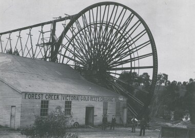 Bendigo Historical Society Inc.
Photograph - FOREST CREEK GOLD MINES CRUSHING BATTERY AT CHEWTON, c.1890
Black and white photograph. Forest Creek (Victoria) gold reefs crushing works. The Garfield overshot waterwheel which drove the battery at Chewton. Inscriptions on back: 'MNG 31''Garfield Mine, Chewton, J Ebbett, Manager' ( in top LHC), 'Royal Historical Society of Victoria, Bendigo Branch' (in circular rubber stamp). History of object: Previous ACC. No. 'MNG 31', Ralph Birrell 5.11.1999 'Garfield Waterwheel and Crushing Mill, Chewton:' Gardield overshot waterwheel which drove the Forest Creek Gold Mines crushing battery at Chewton. The foundations of this wheel can still be seen today.Bendigo Advertiserbuildings, commercial, garfield waterwheel at chewton -
 Eltham District Historical Society Inc
Document - Folder, Phillips, Dr
Dr Phillips had land on Aitken's Creek, near Arthur's Creek by the Greensborough Road where gold had been found in 1864. Contents Photocopies: Victorian Parliamentary Papers, 1864-1865, Vol, 3, No. 22, "Reports of Collectors of Agricultural Statistics", pp95-96.Newspaper clippings, A4 photocopies, etcdr phillips, greensborough road, kangaroo ground, tarrawarra, arthur's creek, county of evelyn, warrandyte -
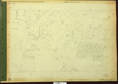 Greensborough Historical Society
Map, Melbourne and Metropolitan Board of Works. Survey Division, MMBW, Yarra 2500 / 15.23. Diamond Creek Reserve, 1978_02
Melbourne and Metropolitan Board of Works. Yarra 2500 [base map] 15.23. Hurstbridge. Municipality of Diamond Valley 257. Prominent streets include: Challenger Street, James Cook Drive and Ryans Road / Main Street. Features include the Diamond Creek and Diamond Creek Reserve.MMBW Map in 1:2500 [scale] series. Cream parchment with green tape reinforcing on edges and punched holes on left edge.mmbw, melbourne and metropolitan board of works, shire of diamond valley, diamond creek - maps -
 Eltham District Historical Society Inc
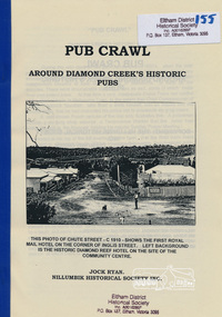
Book, Nillumbik Historical Society, Pub Crawl: around Diamond Creek's historic pubs by Jock Ryan, 2001
Hotels described include: Evelyn Arms Hotel or Tunnel Camp Hotel or Half-Way House, the Diamond Reef Hotel, the Loyal Diamond Lodge Hotel and the Royal Mail Hotel all located in Diamond Creek during a rapid population growth in Diamond Creek in the 1860s.This small publication discusses the history of local hotels in the Diamond Creek area during a significant period of development in the 1860s when mining took place in the local area. The history of hotels connects to the wider history and important social and civic link to the community at that time. [10] p. includes text and very poor photocopy reproductions of historical photographs. Perfect bound with plastic front cover only.EDHS Property stamp on front coverdiamond creek, hotels, pubs, bars, 1860s -
 Whitehorse Historical Society Inc.
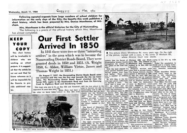
Article, Our First Settler Arrived 1850, 11/03/1964
A4 photocopy of the history of the City of Nunawadingnon-fictionA4 photocopy of the history of the City of Nunawadingnunawading district roads board, city of nunawading -
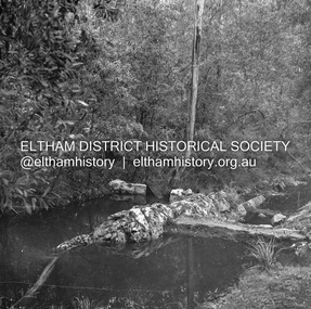
 Eltham District Historical Society Inc
Album - Photograph, J.A. McDonald, Eltham-Yarra Glen Road, Jan. 1956
Watsons Creek Showing steel grids January 1956 Wally WolfRecord of various Shire of Eltham infrastructure works undertaken during the period of 1952-1962 involving bridge and road reconstruction projects, sometimes with Eltham Shire Council Project Reference numbers quoted. It was during this period that a number of significant improvements were made to roads and new bridges constructed within the shire that remain in place as of present day (2022). In many situations, the photos provide a tangible visible record of infrastructure that existed throughout the early days of the Shire. The album was put together by or under the direction of the Shire Engineer, J.A. McDonald.infrastructure, road construction, shire of eltham, bridge construction, 1956-01, eltham-yarra glen road, w.e. wolf, watsons creek -
 Eltham District Historical Society Inc
Album - Photograph, J.A. McDonald, Eltham-Yarra Glen Road, 26 Jan. 1956
Watsons Creek Showing method of jointing at floor 27th January 1956Record of various Shire of Eltham infrastructure works undertaken during the period of 1952-1962 involving bridge and road reconstruction projects, sometimes with Eltham Shire Council Project Reference numbers quoted. It was during this period that a number of significant improvements were made to roads and new bridges constructed within the shire that remain in place as of present day (2022). In many situations, the photos provide a tangible visible record of infrastructure that existed throughout the early days of the Shire. The album was put together by or under the direction of the Shire Engineer, J.A. McDonald.infrastructure, road construction, shire of eltham, bridge construction, eltham-yarra glen road, w.e. wolf, watsons creek, 1956-01-27 -
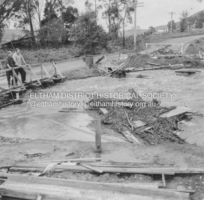 Eltham District Historical Society Inc
Album - Photograph, J.A. McDonald, Heidelberg-Kinglake Road, 18 Oct. 1956
Yarra Glen-Glenburn Road Jehosophat Creek 18th October 1956Record of various Shire of Eltham infrastructure works undertaken during the period of 1952-1962 involving bridge and road reconstruction projects, sometimes with Eltham Shire Council Project Reference numbers quoted. It was during this period that a number of significant improvements were made to roads and new bridges constructed within the shire that remain in place as of present day (2022). In many situations, the photos provide a tangible visible record of infrastructure that existed throughout the early days of the Shire. The album was put together by or under the direction of the Shire Engineer, J.A. McDonald.infrastructure, shire of eltham, bridge construction, heidelberg-kinglake road, road construction, 1956-10-18, flood damage, floods, floodwater, jehosophat creek, yarra glen-glenburn road -
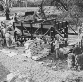 Eltham District Historical Society Inc
Album - Photograph, J.A. McDonald, Yarra Glen-Glenburn Road, June 1957
Jehosophat Creek – 56M295 June 1957 Mixing procedure deck pourRecord of various Shire of Eltham infrastructure works undertaken during the period of 1952-1962 involving bridge and road reconstruction projects, sometimes with Eltham Shire Council Project Reference numbers quoted. It was during this period that a number of significant improvements were made to roads and new bridges constructed within the shire that remain in place as of present day (2022). In many situations, the photos provide a tangible visible record of infrastructure that existed throughout the early days of the Shire. The album was put together by or under the direction of the Shire Engineer, J.A. McDonald.infrastructure, shire of eltham, bridge construction, jehosophat creek, road construction, yarra glen-glenburn road, 1957-06 -
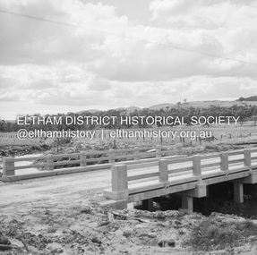 Eltham District Historical Society Inc
Negative - Photograph, J.A. McDonald, Old Healesville Road, Sep 1959
Paul Creek Road Prestressed slabs September 1959 Bridge finishedRecord of various Shire of Eltham infrastructure works undertaken during the period of 1952-1962 involving bridge and road reconstruction projects, sometimes with Eltham Shire Council Project Reference numbers quoted. It was during this period that a number of significant improvements were made to roads and new bridges constructed within the shire that remain in place as of present day (2022). In many situations, the photos provide a tangible visible record of infrastructure that existed throughout the early days of the Shire. The album was put together by or under the direction of the Shire Engineer, J.A. McDonald.infrastructure, shire of eltham, bridge construction, 1959-09, old healesville road, paul creek road -
 Eltham District Historical Society Inc
Negative - Photograph, J.A. McDonald, Hurstbridge Water Scheme, 11 May 1961
Showing layout of weir http://wikimapia.org/10473910/Running-Creek-ReservoirRecord of various Shire of Eltham infrastructure works undertaken during the period of 1952-1962 involving bridge and road reconstruction projects, sometimes with Eltham Shire Council Project Reference numbers quoted. It was during this period that a number of significant improvements were made to roads and new bridges constructed within the shire that remain in place as of present day (2022). In many situations, the photos provide a tangible visible record of infrastructure that existed throughout the early days of the Shire. The album was put together by or under the direction of the Shire Engineer, J.A. McDonald.infrastructure, road construction, shire of eltham, 1961-05-11, hurstbridge water scheme -
 Eltham District Historical Society Inc
Photograph, Jim Connor, Main Road, Eltham, 14 Jan 2017
Eltham Gateway, Main Road Bridge, Eltham over the Diamond CreekTomorrow's history documented todayeltham, jim connor collection, main road, eltham gateway, main road bridge, wingrove park trail, diamond creek -
 Greensborough Historical Society
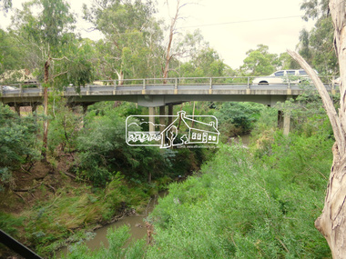
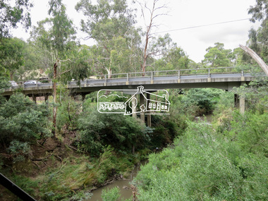
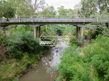
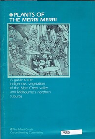
Book, Norman Anderson, Plants of the Merri Merri: a guide to the indigenous vegetation of the Merri Creek valley and Melbourne's northern suburbs, 1984
64 p., black & white illustrationsnon-fictionmerri creek, native flora -
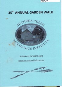 Greensborough Historical Society
Booklet, Arthurs Creek Mechanics Institute, 35th Garden Walk, Arthurs Creek Mechanics Institute, 22/10/2023
Garden walk through various gardens in Arthurs Creek and surrounding areas. 12 page booklet, line drawings.arthurs creek mechanics institute, arthurs creek, doreen, diamond creek, hurstbridge -
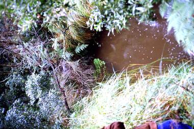 Greensborough Historical Society
Slide - Photograph, John Ramsdale, Plenty River, upstream from Gorge: Slide 42, 1990s
Photograph shows creek bed with vegetation, upstream from Plenty Gorge.Part of the John Ramsdale collection of slides and audio visual material.Colour photograph scanned from slide.No caption. Printed maker's mark on slide "Kodak Kodachrome Slide"plenty gorge, plenty river, mernda -
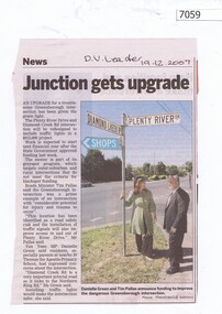 Greensborough Historical Society
Newspaper Clipping, Junction gets upgrade, 19/12/2007
Article on the upgrade of the Diamond Creek Road and Plenty River Drive intersection. Black and white text, colour imageplenty river drive greensborough, diamond creek road greensborough -
 Greensborough Historical Society
Photograph - Digital Image, Ryan's butcher's Diamond Creek, 1945_
The butcher's shop owned by the Ryan family in Diamond Creek, about 1945.Digital copy of black and white photograph a.d. ryans, ryans butchers, diamond creek -
 Bendigo Historical Society Inc.
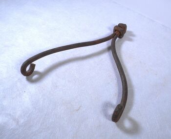
Tool - HARRIS Collection Metal Hooks
Jonathan Harris operated a winery on the banks of the Axe Creek, Axedale in the 1850s. Metal hook combination is made from one and a half centimetre diameter metal in two pieces, with four centimetre circles on each end 40 centimetres long. They are joined at the top by a threaded section with a square nut, a thin metal washer and a one centimetre thick four centimetre wide square metal piece. Part of the Harris Collectionagriculture, farm, hanging hooks -
 Bendigo Historical Society Inc.
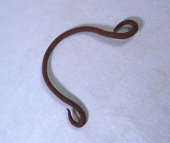
Functional object - HARRIS Collection Metal Hook
Jonathan Harris operated a winery on the banks of the Axe Creek, Axedale in the 1850s. Metal hook combination is a one centimetre diameter piece of metal in a horseshoe shape with a pointed four centimetre diameter circle on each end. Part of the Harris Collectionagriculture, farm, hanging hooks, harris collection -
 Bendigo Historical Society Inc.
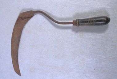
Functional object - Harris Collection Hand Scythe
Jonathan Harris operated a winery on the banks of the Axe Creek, Axedale in the 1850s.A curved metal blade 31 centimetres long eight centimetres wide tapering to a point. Attached to a one centimetre diameter, 18 centimetre long curved metal rod which has a two centimetre to three centimetre tapered 11 centimetre long wooden handle. Part of the Harris Collection.agriculture, farm, harris collection, hand scyche -
 Bendigo Historical Society Inc.
Functional object - Harris Collection Walking Staff
Jonathan Harris operated a winery on the banks of the Axe Creek, Axedale in the 1850s.A walking stick shaped from two intersecting thin branches and has some carving on it. Part of the Harris Collection.harris collection, wooden walking staff