Showing 53841 items
matching documents-maps
-
 Ballarat Tramway Museum
Document - Re typed article, "Cable and rope traction", c1950
Three page typed copy of an article appeared in Engineering 1887 on Melbourne cable tramways construction. Carbon copy of typing on both sides of 1 sheet and 1 sheet of pink paper with hand drawn copy of a map in 4 colours. Image of document added 25/8/2013.trams, tramways, melbourne, cable trams, construction -
 Greensborough Historical Society
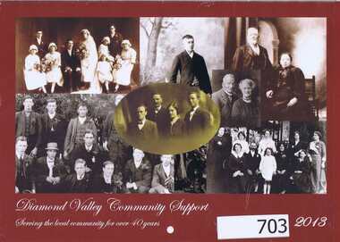
Calendar, Diamond Valley Community Support Inc. Annual Report 2011-2012. Calendar. 2013, 2011-2013
The annual report of Diamond Valley Community Support Inc. is presented in a calendar format. In this 2013 edition the calendar is illustrated with photographs of Greensborough pioneer families. The attached Word file contains captions identifying the people in the photographs. Captions by Faye Fort.The annual report is a record of the activities and services of Diamond Valley Community Support Inc.28 pages. Colour and black and white illustration. Annual report in calendar format. Illustrations of Greensborough pioneer families. A handwritten insert identifies the people in the photographs. (Notes by Faye Fort, typed by Merilyn Mullavey 2016, see Word document)diamond valley community support inc. -
 Whitehorse Historical Society Inc.
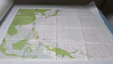
Map, Aerial photographs Nunawading, 1972
Department of Crown Lands and Survey, Melbourne, 1972.Department of Crown Lands and Survey, Melbourne, 1972. Project runs 34 - 39 - City of Nunawading. frames numbered from South to North boundaries, each strip numbered from West to east. The series extends further West to Box Hill and East to Ringwood than the 1970 project. No index map. Sheets 39/2 and 34/28 missing.non-fictionDepartment of Crown Lands and Survey, Melbourne, 1972.victoria. department of crown lands and survey, aerial photographs, nunawading, mitcham, blackburn, blackburn north, blackburn south, forest hill, vermont, burwood east, box hill, ringwood, vermont south -
 Kiewa Valley Historical Society
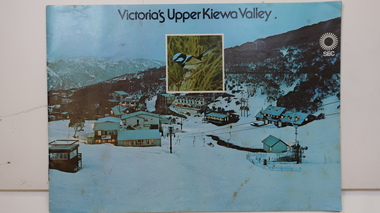
Booklet - SEC x2, 1. Victoria's Kiewa Valley 2. Victoria's Upper Kiewa Valley, No. 2 is dated October 1978
The State Electricity Commission of Victoria built the Kiewa Hydro Electric Scheme and was keen to promote tourism in the area. The booklet includes Facilities, Falls Creek Ski Resort, the Kiewa Works Area, the Three Floras of Bogong, the Geology of the Kiewa area, the Bird and Animal life of Bogong and the Kiewa Hydro Electric Scheme. The colored photos and the map on the back appeal to the reader/tourist.The SECV promoted tourism in the Kiewa Valley especially the area of the Kiewa Hydro Electric Scheme. This booklet is attractive and informative with a lot of detail. This proved to be the early stages of tourism in the area in what is now a very popular tourist destination and the main industry for the Upper Kiewa Valley.Blue cover with photo of Falls Creek at night. Title in black print at the centre top under which is an insert photo of a blue wren and SEC logo in white towards the top far right. Back cover is light green with a tourist map of the area. The text is complimented with brightly colored photos throughout.state electricity commission of victoria; kiewa hydro electric scheme; tourism; bogong; flora; fauna; geology; -
 Orbost & District Historical Society
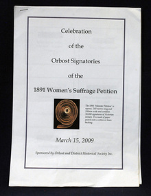
document, Celebration of the Orbost Signatures of the 1891 Women's Suffragette Petition, 2009
In 1891, Premier James Munro said he would introduce a bill into parliament for women's suffrage if it were demonstrated that ordinary women wanted this right. The Victorian Woman's Temperance Union and the Victorian Women's Suffrage Society took up the challenge, joining forces to organise a petition. Embarking on a door knocking campaign across Victoria they collected about 30,000 signatures in six weeks. The 'Monster Petition' is housed at the Public Records Office Victoria where a purpose-built perspex case protects the 260 metres of signed pages glued to sewn swathes of calico. (ref. Creative Victoria). In 2008 the petition was a centrepiece of the centenary celebrations of women's suffrage. This document was prepared for that centenary celebration.The Women's Suffrage Petition (1891) reflects the dedicated work of those women, who went from door to door across Victoria to collect the signatures. Its tremendous length earned it the name of the ‘Monster Petition'. This document is a useful research item.A stapled 9 pp document containing names, photographs, signatures of the Orbost women who signed the petition for Women's Suffrage in 1891.women's-suffrage-orbost -
Glenelg Shire Council Cultural Collection
Map, 1885
Significant collection relating to the social history across the shire.Map, Victoria. Skeleton map of Telegraph Circuits and Railways 1885. Scale 16 miles to 1 inch.map, skeleton map, telegraph, railways, 1885, 1880s -
Bendigo Historical Society Inc.
Map - KANGAROO FLAT, 27/.01/1932
Map: Township of Kangaroo Flat, Parish of Sandhurst, County of Bendigo ( number 148 in Map Cupboard 1)map, bendigo, township, kangaroo flat, parish of sandhurst, county of bendigo -
Bendigo Historical Society Inc.
Map - LANGWORNOR SHEET 2, 26/06/1889
Map: Langwornor sheet 2, County of Dalhousie. Parish plan ( number 173 in Map Cupboard 1)map, dalhousie, parish plan, langwornor, county of dalhousie -
Bendigo Historical Society Inc.
Map - LANGWORNOR SHEET 1, No date visible
Map: Langwornor sheet 1, County of Dalhousie. Parish plan ( number 174 in Map Cupboard 1)map, dalhousie, parish plan, langwornor, county of dalhousie -
Bendigo Historical Society Inc.
Map - RESURVEY, PARISH OF SANDHURST, 1/08/1891
Map: Resurvey , Parish of Sandhurst sheet 3. Parish plan ( number 203 in Map Cupboard 1)map, bendigo, parish plan, parish of sandhurst resurvey -
Bendigo Historical Society Inc.
Map - SANDHURST SHEET 1, No date visible
Map: Sandhurst ,County of Bendigo sheet 1. Parish plan ( number 201 in Map Cupboard 1)map, bendigo, city streets, sandhurst -
Bendigo Historical Society Inc.
Map - LANDS AVAILABLE FOR SELECTION, 6/05/1912
Map: Lands available for selection, County of Bendigo. Parish plan ( number 192 in Map Cupboard 1)map, bendigo, lands available for selection, lands available for selection, bendigo -
Bendigo Historical Society Inc.
Map - HARCOURT, No date visible
Map: Township of Harcourt, Parish pf Harcourt, County of Talbot, (number 265 in map cupboard 1)map, talbot, township, harcourt -
Bendigo Historical Society Inc.
Map - CITY OF SANDHURST RESURVEY SHEET 2, 23/05/1881
Map City of sandhurst Resurvey, sheet 2. Parish plan ( number 231 in Map Cupboard 1)map, bendigo, parish plan, sandhurst resurvey -
Bendigo Historical Society Inc.
Map - CITY OF BENDIGO RESURVEY SHEET 1, 5/06/1903
Map: City of Bendigo resurvet sheet 1. Parish plan ( number 219 in Map Cupboard 1)map, bendigo, parish plan, bendigo resurvey -
Bendigo Historical Society Inc.
Map - CITY OF BENDIGO RESURVEY SHEET NO. 3, Circa 1900
Map: City of Bendigo Resurvey sheet No. 3. Parish plan ( number 214 in Map Cupboard 1)map, bendigo, parish plan, bendigo, resurvey -
Bendigo Historical Society Inc.
Map - WELLSFORD, 4/07/1876
Map: Parish of Wellsford, County of Bendigo. Strathfieldsaye, Wellsford , Bagshot (number 311 in map cupboard 1)map, bendigo, parish plan, wellsford -
Bendigo Historical Society Inc.
Map - PARISHES OF WARRAGAMBA AND MINTO, No date visible
Map: Parishes of Warragamba and Minto,Hand draughted parish plan. (number 290 in map cupboard 1)map, parish plan, warragamba, minto -
Bendigo Historical Society Inc.
Map - KAMAROOKA ALLOTMENTS, 7/06/1894
Map: Parish of Kamarooka Allotments, County of Bendigo. Parish plan (number 288 in map cupboard 1)map, bendigo, allotments, kamarooka, allotments -
Bendigo Historical Society Inc.
Map - BRIDGEWATER, 10/09/1913
Map: Bridgewater, Parishes of Bridgewater and Inglewood, Counties of Bendigo and Gladstone (number 276 in map cupboard 1)map, bendigo, parish plan, bridgewater -
Bendigo Historical Society Inc.
Map - NEILBOROUGH, 6/12/1882
Map: Parish of Neilborough, County of Bendigo. Parish plan. Earliest date on map 21/8/1877.map, bendigo, parish plan, neilborough -
Bendigo Historical Society Inc.
Map - BAGSHOT, Circa 1878
Map: Parish of Bagshot, County of Bendigo. Parish plan (coloured) (number 329 in map cupboard 1)map, bendigo, parish plan, bagshot -
Bendigo Historical Society Inc.
Map - GOORNONG, 29/04/1879
Map: Parish of Goornong, County of Bendigo. Parish plan (coloured) (number 326 in map cupboard 1)map, bendigo, parish plan, goornong -
Bendigo Historical Society Inc.
Map - INGLEWOOD, 17/12/1877
Map: Parish of Inglewood, County of Gladstone. Parish plan. Earliest date on map 31/12/75.map, gladstone, parish plan, inglewood -
 National Vietnam Veterans Museum (NVVM)
Map, Map Cloth
Cloth map of Western Pacific region noting countries and water currents around. map is double sidedmap -
Koorie Heritage Trust
Book, Beauglehole, A. C. & H. M, The distribution and conservation of vascular plants in the north east area, Victoria, 1988
ii, 98 p. : ill., maps ; 21 x 30 cm. + 1 folded col. map.botany -- victoria, northeastern. -
Koorie Heritage Trust
Book, Beauglehole, A. C, The distribution and conservation of vascular plants in the north central area, Victoria, 1982
iv, 102 p. : ill., maps ; 22 x 30 cm. + 1 col. folded map.indigenous vascular plants. distribution. northern victoria | botany -- victoria. -
 Ballarat Heritage Services
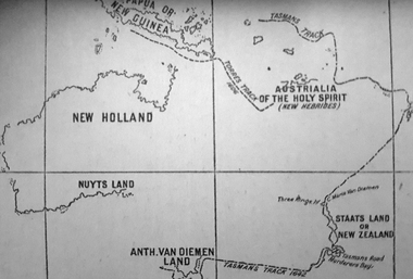
Photograph - Map, A Sketch from Dalyrmples Map of 1767, 1767
Copy of a map showing the coast that was known during the voyge of the Endeavour, and the first map that marks Torres track.map, new holland, hollandia nova, isaac de graaff, new guinea, australia of the holy spirit, papua, new hebrides, new zealand, nuyts land, van dieman's land, tasman's track, torres -
 Bendigo Military Museum
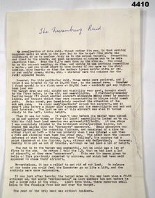
Document - ACCOUNT OF A WW2 BOMBING RAID, F.G. Davey, c. 1972
The document details F.G. Davey's eyewitness account of a raid on Nuremburg, Germany during WW2. On return from the raid the Lancaster Davey was piloting was damaged in an attack by a JU-88. See catalogue no. 4411P which shows the damage to the aircraft. Part of the F.G. Davey Collection. See 3536P for his service record.Single page document in black type on cream coloured foolscap sized paper. The text consists of seven paragraphs. The paper bears two watermarks each stating 'BURNIE BANK. MADE IN AUSTRALIA'.Heading handwritten in blue ink: 'The Nuremburg Raid'.bombing raids, f.g. davey, personal stories, raid on nuremburg -
 Eltham District Historical Society Inc
Photograph, Sgt Tyrrell George Evans with fiancee, Mary Pitt Withers outside the Withers family home, Southernwood, Bolton Street, Eltham, c.1917
Present day Google Street View https://goo.gl/maps/PZZMoEdJYUXbgf4a8 Tyrrell George Granville Evans was born on 17th August 1892 Enlisted (No. 789) 7 July 1915 as a Private and was assigned to the 31st Battalion. Promoted to Sergeant 1 Nov 1915. Disembarked Suez 7 Feb 1916 Admitted to 32nd Stat. Hospital in France 21 July 1916 with a gunshot wound to the left arm. According to daughter-in-law, Janet Evans, on 19 July 1916, in the battle near Pozieres on the Somme, he was hit by a German high explosive shell and was unconscious and badly wounded. His left arm was shattered, and he had a bullet wound on his leg. Embarked at Boulogne on H.S. Cambria for Middlesex War Hospital, England 24 July 1916. Evans returned to Australia and was discharged medically unfit, 7 April 1917. After months in the Caulfield Hospital his arm could not be saved, and it was amputated 18 July 1917. On July 6, 1918, Tyrrell George Granville Evans married Mary Pitt Withers at Eltham, daughter of artist Walter Herbert Withers (deceased) and wife Fanny (nee Flinn). They had three children, Mary Roberta Evans born February 8, 1921, at Balwyn and twins Shirley and Joyce born June 10, 1922. Mary died 17 days later, June 27, 1922, at Balwyn. Tyrrell had to cope with three children under three years old and a missing left arm. He had been lefthanded before his war injuries. He had help from the family, especially his sister. On August 1, 1924, Tyrrell George Granville Evans married Marian Frances Wilcox and they had two children: Barbara Marian, born 27 July 1925 and Tyrrell Granville, born 3 July 1928. The children were all brought up together in Glen Iris. Tyrrell became renowned as a one-armed golfer and tennis player. He was Senior Vice-President of the Lawn Tennis Association of Victoria and was on the committee of the Metropolitan Golf Club. At the time of his retirement, he was General Manager of the Colonial Meat Company. Tyrrell died September 3, 1962 and was succeeded by sixteen grandchildren. Contributed to by Janet Evans (daughter-in-law), 27 May 2024Many items in this collection have suffered from significant water damage and black mouldjohn withers collection, eltham, tyrrell george granville evans, mary pitt withers, 1917, bolton steet, scan - 620 format 6x9 negative, southernwood