Showing 4550 items matching "historical map"
-
 Bendigo Historical Society Inc.
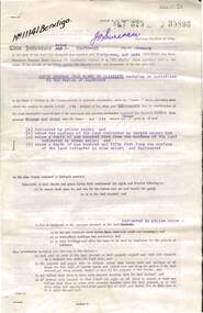
Document - VARIOUS DOCUMENTS FROM 'BOX 511'
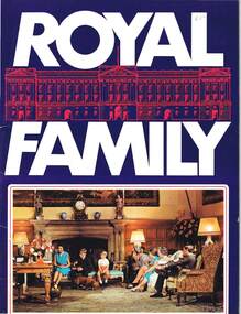
Various documents from 'Box 511': a. 'Royal Family' - re filmed portrait of Queen Elizabeth II (1959); b. 'Scientific American', issue of April 1934; c. 'Band of Hope Review, 1867 - published in England (Baptist); d. 'Beautiful Britain' - Art Series No 6 - Scenery of the United Kingdom, m1894; e. as for d. but Series 10; f. as for d. but Series 11; g. as for d. but Series unknown (no cover); h. 'Hobart and Suburbs' = Aerial Survey Maps (street directory), 1954 - ex libris A. Richardson, 1959; I. 'Weekly Times Annual, Dec 10, 1931 - cover and pages missing; j. 'Table Talk Christmas Annual, Dec 3, 1923 (cover and pages missing)document -
 Bendigo Historical Society Inc.
Map - NERRING, August 1952
Map: Nerring, County of Bendigo. Parish plan ( number 180 in Map Cupboard 1)map, bendigo, parish plan, nerring, county of bendigo -
Bendigo Historical Society Inc.
Map - SALISBURY WEST, 14/10/1943
Map: Salisbury West, County of Gladstone. Parish plan ( number 179 in Map Cupboard 1)map, gladstone, parish plan, salisbury west , county of gladstone -
Bendigo Historical Society Inc.
Map - HAWKESTONE, 17/11/1915
Map: Hawkestone, County of Talbot. Parish plan ( number 178 in Map Cupboard 1)map, talbot, parish plan, hawkestone, county of talbot -
Bendigo Historical Society Inc.
Map - HARCOURT, September 1951
Map: Harcourt, County of Talbot. Parish plan ( number 177 in Map Cupboard 1)map, talbot, parish plan, harcourt, county of talbot -
Bendigo Historical Society Inc.
Map - PARISH OF LAANECOORIE, 13/10/1930
Map: Parish of Laanecoorie, County of Bendigo. Parish plan ( number 176 in Map Cupboard 1)map, bendigo, parish plan, laanecoorie -
Bendigo Historical Society Inc.
Map - KIMBOLTON, 24/05/1921
Maqp: Kimbolton, County of Bendigo. Parish plan ( number 175 in Map Cupboard 1)map, bendigo, parish plan, kimbolton -
Bendigo Historical Society Inc.
Map - LANGWORNOR SHEET 2, 26/06/1889
Map: Langwornor sheet 2, County of Dalhousie. Parish plan ( number 173 in Map Cupboard 1)map, dalhousie, parish plan, langwornor, county of dalhousie -
Bendigo Historical Society Inc.
Map - LANGWORNOR SHEET 1, No date visible
Map: Langwornor sheet 1, County of Dalhousie. Parish plan ( number 174 in Map Cupboard 1)map, dalhousie, parish plan, langwornor, county of dalhousie -
Bendigo Historical Society Inc.
Map - KIMBOLTON, No date Visible
Map: Kimbolton, County of Bendigo. Parish plan ( number 172 in Map Cupboard 1)map, bendigo, parish plan, kimbolton -
Bendigo Historical Society Inc.
Map - COLBINABBIN, June 1951
Map: Colbinabbin, County of Rodney. Parish planmap, rodney, parish plan, colbinabbin, county of rodney -
Bendigo Historical Society Inc.
Map - WHIRRAKEE, 1971
Map: Whirrakee, County of Bendigo. Parish plan ( number 171 in Map Cupboard 1)map, bendigo, parish plan, whirrakee -
Bendigo Historical Society Inc.
Map - EPPALOCK, 15/11/1928
Map: Eppalock, County of Bendigo. Parish plan ( number 170 in Map Cupboard 1)map, bendigo, parish plan, eppalock -
Bendigo Historical Society Inc.
Map - EGERTON, 1/03/1890
Map: Egerton, County of Bendigo. Parish plan ( number 169 in Map Cupboard 1)map, bendigo, parish plan, egerton -
Bendigo Historical Society Inc.
Map - HUNTLY, August 1945
Map: Huntly, County of Bendigo, Parish plan ( number 168 in Map Cupboard 1)map, bendigo, parish plan, huntly, county of bendigo -
Bendigo Historical Society Inc.
Map - BAGSHOT, November 1948
Map: Bagshot, County of Bendigo. Parish plan ( number 167 in Map Cupboard 1)map, bendigo, parish plan, bagshot, county of bendigo -
Bendigo Historical Society Inc.
Map - LYELL, 16/04/1935
Map: Lyell, County of Bendigo. Parish plan ( number 166 in Map Cupboard 1)map, bendigo, parish plan, lyell, county of bendigo -
Bendigo Historical Society Inc.
Map - LANGWORNOR, 17/07/1942
Map: Langwornor, County of Dalhousie. Parish Plan, coloured ( number 165 in Map Cupboard 1)map, dalhousie, parish plan, langwornor, county of dalhousie -
Bendigo Historical Society Inc.
Map - MARONG, June 1953
Map: Marong, County of Bendigo. Parish plan ( number 164 in Map Cupboard 1)map, bendigo, parish plan, marong, county of bendigo -
Bendigo Historical Society Inc.
Map - COSTERFIELD, 2/09/1939
Map: Costerfield, Counties of Dalhousie and Rodney. Parish plan ( number 163 in Map Cupboard 1)map, dalhousie, parish plan, costerfield, counties of dalhousie and rodney -
Bendigo Historical Society Inc.
Map - DARGILE, November 1953
Map: Dargile, County of Rodney. Parish plan ( number 162 in Map Cupboard 1)map, rodney, parish plan, dargile , county of rodney -
Bendigo Historical Society Inc.
Map - PARISH OF SANDHURST SHEET 5A, 1970
Map: Parish of Sandhurst Sheet 5A, County of Bendigo. Parish plan ( number 161 in Map Cupboard 1)map, bendigo, parish plan, parish of sandhurst, county of bendigo -
Bendigo Historical Society Inc.
Map - BENDIGO IRRIGATION SETTLEMENT, 12/02/1908
Map: Plan of Bendigo Irrigation Settlement, Parishes of Sandhurst and Wellsford, County of Bendigo ( number 160 in Map Cupboard 1)map, bendigo, irrigation settlement, bendigo irrigation settlement, parishes of sandhurst and wellsford, county of bendigo -
Bendigo Historical Society Inc.
Map - ELMORE, 7/08/1911
Map: Township of Elmore, Parish of Elmore, County of Bendigo ( number 159 in Map Cupboard 1)map, bendigo, township, elmore, county of bendigo -
Bendigo Historical Society Inc.
Map - MANDURANG, 8/10/1887
Parish of Mandurang, County of Bendigo. Traced from a re-survey of the Parish of Mandurang by Mr. Geo. Black 8/10.1887 ( number 158 in Map Cupboard 1)map, bendigo, parish plan, mandurang, re-survey, couny of bendigo -
 Bendigo Historical Society Inc.
Book - EARLY DAYS IN THE LODDON VALLEY, 1966
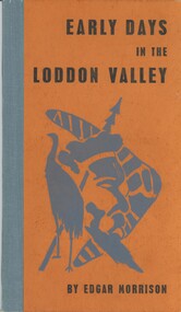
Early days in the Loddon Valley, Memoirs of Edward Stone Parker 1802-1865, 98 Pages, with photographs and maps, Limited Edition of 1000 copies,Edgar Morrisonhistory, australian, loddon valley, history of loddon valley, castlemaine, daylesford, edward stone parker, aborigines, aboriginal stations -
 Bendigo Historical Society Inc.
Document - MCCOLL, RANKIN AND STANISTREET COLLECTION: DEBORAH EXTENDED GOLD MINING COMPANY NL, 1940
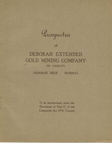
McColl Rankin & Stanistreet, 12 Copies of Prospectus of Deborah Extended Gold Mining Company No Liability, Deborah Reef, Bendigo. To be incorporated under the Provisions of Part II, of the Companies Act 1938, Victoria. Application form and map of mines included in book form, dated 1940. Profit and Loss Account for Term ended 31st August, 1945 also included on separate sheet (has been folded in half across). Auditors: Wm. R. McKie & W. J. Sparkman.organization, mining, deborah extended gold mining cpy nl, mccoll rankin & stanistreet, deborah extended gold mining company nl, prospectus, profit and loss account for 31 august 1945, map of mine, form application -
 Bendigo Historical Society Inc.
Document - MCCOLL, RANKIN AND STANISTREET COLLECTION: ALICE PEEL GOLD MINING LEASE DOCUMENT, 8/7/1945
Document : McColl, Rankin and Stanistreet - gold mining lease document in name of Alice Peel, Executrix of Will of Edward Peel, deceased. 3 pages with map. No. 11198, Vol. 328., Fol. 36141. Lease crosses Houston Street, Quarry Hill. Transferred to South Deborah Gold Mines NL on 15/8/1946.organization, mining, south deborah gold mines nl, mccoll, rankin and stanistreet, alice peel, edward peel, gold mining lease, gold mining -
 Bendigo Historical Society Inc.
Document - MCCOLL, RANKIN AND STANISTREET COLLECTION: SOUTH DEBORAH GOLD MINES NL GOLD LEASE DOCUMENT, 14/1/1941
Document: McColl, Rankin and Stanistreet - South Deborah Gold Mines NL. Gold mining lease document. No. 11141, Vol. 325, Fol. 35893. Lease adjoins Railway Reserve, Breen Street. Attached to plan with pin piece of paper, written in pencil ' application Atherton 14/4/46 - consent refused - hand drawn map with Honeybone Street.organization, mining, south deborah gold mines nl, mccoll, rankin and stanistreet, south deborah gold mines nl, gold mining lease documents -
 Bendigo Historical Society Inc.
Document - MCCOLL, RANKIN AND STANISTREET COLLECTION: CENTRAL DEBORAH GOLD MINING COMPANY N/L GOLD MINING LEASE, 31 October 1950
Document: Central Deborah Gold Mining Company N/L gold mining lease. 4 page document with attached map. Map shows area from Breen Street to Victoria Street following the line of Old Violet Street.. Lease between Central Deborah Gold Mining Company N/L and the State of Victoria. No. 11230, Vol 331 Fol 36471.organization, mining, gold mining lease, central deborah gold mining company n/l; gold mining lease