Showing 123961 items
matching main-road
-
 Whitehorse Historical Society Inc.
Map, Burwood Road, Box Hill City, 15/02/1952 12:00:00 AM
Plan of subdivision of 19 blocks in Burwood Road, Burwood.Plan of subdivision of 19 blocks in Burwood Road, Burwood between Greenwood Street and Middleborough Road. Marked as Survey Plan No 5442.Plan of subdivision of 19 blocks in Burwood Road, Burwood. land subdivision, burwood road, burwood, greenwood street, burwood, middleborough road, burwood -
Whitehorse Historical Society Inc.
Newspaper - Article, 178 Central Road, Nunawading, 18/04/1994
178 Central Road, Nunawading, Auction, Sunday 1 May 1994, Californian Bungalow, c1930 vintage with original features.central road, nunawading, californian bungalows, auctions -
Whitehorse Historical Society Inc.
Newspaper - Article, Junction Road, Blackburn North, 12/04/1995
7 - 21 Junction Road, Blackburn North. Article on weatherboard home c1903, Harwood Homestead, Edwardian / Federation house.harwood, junction road, blackburn north, nos. 17-21, killeen avenue, blackburn north, handley court, blackburn north, edwardian style, auctions -
 Surrey Hills Historical Society Collection
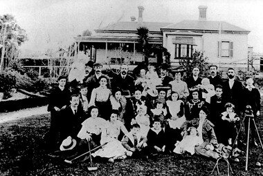
Photograph, Beckett family gathering at 4 Essex Road, 1904
The family members are identified as follows: Back row (L to R): Percy Leigh with Phyllis, Robert Beckett (junior), Herbert Ingamells, Annie Leigh with Marjorie, Harry Leigh, Clara Beckett, Arnold Bear (brother of Olly Beckett), William Beckett with Edna, Ben Gray. Middle row (L to R): Robert Gray, Ethel Beckett, Polly (sister-in-law of Harry Leigh), Nelly Ingamells, Eliza Beckett with Esther Leigh, Alice Beckett with Basil, Dorothy Beckett, Olly Beckett, Emma Gray with Norman. Front row (L to R): ??? (a Leigh brother), Kate Beckett, Mabel Beckett, Cyril Ingamells, Bert Gray, Elsie Leigh with Ethel Ingamells. Robert (John Robert) Gray, Ben Gray and Norman Gray were 3 of 6 children of John Gray and Emma Beckett who married at Guildford Villa in 1888. Norman was born in 1901 and looks to be c.3 years old in this photo; the youngest in the family was Evelyn (b 1906) so this would give an approximate date for the photo of 1904. The donor, Wendy McLellan is the daughter of Minnie Caroline Beckett (1907-1998) and Francis James Renkin who married on 13 March 1934. Peter Renkin (formerly of 59 Guildford Road, Surrey Hills, now Shoreham) is her brother. Exact date photo was taken was 17 September 1904.Black and white photo at Guildford Villa, 4 Essex Road, Surrey Hills, home of the Beckett family. The family is formally posed with croquet equipment on the lawn of the substantial Victorian-style home which has 3 chimneys and a veranda on 2 sides. victorian style, croquet, percy leigh, phyllis leigh, robert beckett (junior), herbert ingamells, annie leigh, marjorie leigh, harry leigh, clara beckett, arnold bear, william beckett, edna beckett, ben gray, robert gray, ethel beckett, nelly ingamells, eliza beckett, esther leigh, alice beckett, dorothy beckett, olly beckett, basil beckett, emma gray, norman gray, kate beckett, mabel beckett, cyril ingamells, bert gray, elsie leigh, ethel ingamells -
![Photograph, [Main weaving shed]](/media/collectors/510b3f7f023fd725b4cd52cc/items/54065f5e9821f50e3cc9f4fa/item-media/54065f5e9821f50e3cc9f4fb/item-fit-380x285.jpg) National Wool Museum
National Wool MuseumPhotograph, [Main weaving shed]
Acquired when "Classweave Industries" closed down17 Main weaving room 22/87 p?honetextile mills woollen mills, classweave industries pty ltd federal woollen mills ltd, weaving machinery, textile mills, woollen mills -
Stawell Historical Society Inc
Archive, Thomas Thomas Grocer and Tea Merchant Main Street Stawell 1876, 1876
Account BookThomas Thomas Grocer & Tea Merchant Main Street Stawellstawell -
 University of Melbourne, Burnley Campus Archives
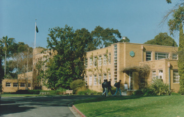
Photograph - Colour print, Main Building, 1991
Colour photograph of 4 students entering Administration Building. On reverse, "Main Building VCAH-Burnley 1991 Northern Aspect."students, administration building, vcah, burnley -
 Stawell Historical Society Inc
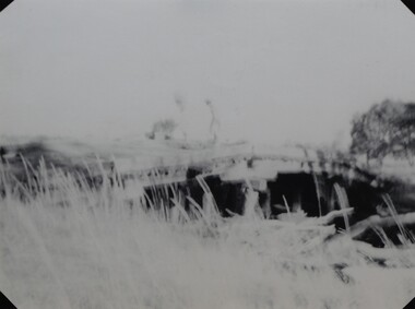
Photograph, Harris Bridge – Red Bend Road -- Great Western
Harris Bridge – Red Bend Road Great Western.Black & white photo of Bridge. Photo is out of focus so hard to work out.Harris' Bridge Red bend Road Great Westernstawell -
 Stawell Historical Society Inc
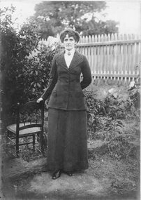
Photograph, Mrs Ede Sowden in the Raitt garden in Upper Main Street Stawell
Portrait of lady in garden beside chair. Noted Aunty Ede passed away 1940. Mrs Ede Sowden was taken in the Garden of the Raitt home upper Main Street.Lady dressed in a dark coloured suit, white high-necked blouse with brooch at centre, standing beside a chair in the garden. Picket fence is in the background.on the back: Nov '83 Lemon tree has just been removed at property of Mrs Raitt , Upper Main Beverley Biggs (possibly Briggs) has the chair - this is her grandma's sister. Family home brought from Creswick by bullock dray. On the front: Auntie Ede passed away 1940stawell -
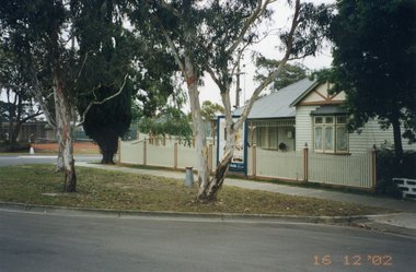 Whitehorse Historical Society Inc.
Photograph, Whitehorse Road, Mitcham No.427
427 Whitehorse Road, Mitcham was owned by the Copp family in the 1950s.|See also NP2519-2520 and NP2560, NP3245Coloured photograph of renovated old house at 427 Whitehorse Road, Mitcham, taken in 2002 from Whitehorse Roadwhitehorse road, mitcham no.427 -
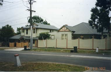 Whitehorse Historical Society Inc.
Photograph, Whitehorse Road, Mitcham No.427
427 Whitehorse Road, Mitcham, was owned by the Copp family in the 1950s|See also NP2519-2520 and NP2560, NP3244Coloured photograph of renovated old house at 427 Whitehorse Road, Mitcham, taken in 2002 from Dunlaven Roadwhitehorse road, mitcham no.427 -
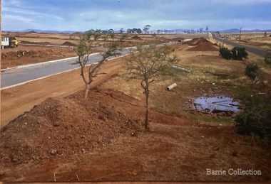 Melton City Libraries
Photograph, West Melton-Coburns Road, 1969
Coburns Road - 19th c family descendents living in Melton. Coburn Primary School Cr George Coburn. 1930’s. December 1935 Shire President Cr Geo Coburn convened meeting to form the Bush Fire Brigade. Road construction of Service road and beginnings of West Melton subdivision. West Melton-Early Division View of Coburns Road. council, local significant events -
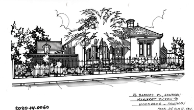 Hawthorn Historical Society
Drawing - Property Illustration, 26 Barkers Road, Hawthorn
'After training as a Cartographic Draftsman within the mining industry, I worked as a property illustrator for real estate firms in the eastern suburbs of Melbourne for 23 years from 1983. I initially photographed houses with a Polaroid camera and made a 'thumbnail' sketch while there. The photos were used to scale off a sketch in pencil and then that sketch was overlaid with drafting film and the 'pen and ink' completed. The pens I used were the Rotring ‘Rapidigraph’ drafting pens. The ink was also made by Rotring (German).The film was ‘Rapidraw’, polyester drafting film, double matte. It takes a very fine line and doesn’t bleed. As well as house sketches, there were often floor plans and site plans ordered. Aerial sketches were ordered when the property needed an overall view.' (Margaret Picken, 2020)This property illustration is one of a series created by Margaret Picken for a range of real estate agents in Melbourne between c. 1983 and c. 2006. Each work is signed and dated by the artist.Gift of Margaret Picken, 2020Pen and ink property illustration on drafting film of 26 Barkers Road, Hawthorn by Margaret Picken.26 Barkers Road, Hawthorn, Margaret Picken '90. Woodards - Hawthorn, rear 35 Elm T, Hawartist - margaret picken 1950- -
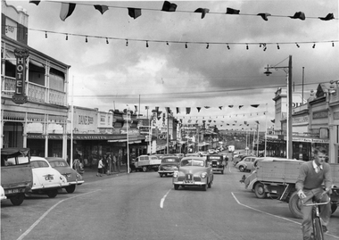 Stawell Historical Society Inc
Photograph, Main Street Stawell looking West with street decorations April 7 1955
Main Street Stawell April 7 1955 looking West with street decoration . Oliver's Bull and Mouth Hotel on Left. Vehicles on roadstawell businesses streetscape -
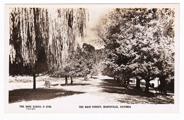 Marysville & District Historical Society
Postcard (item) - Black and white postcard, Rose Stereograph Company, The Main Street, Marysville, Victoria, 1913-1967
A postcard in a series produced by the Rose Stereograph Company in Victoria, Australia as a souvenir of Marysville.A black and white photograph of Marysville's main street. This is now known as Murchison Street.POST CARD The "Rose" Series/ De Luxe A Real Photograph/ Produced in Australia Published by the Rose Stereograph Co.,/ Armadale, Victoria Dear Max./ I arrived here/ about 12AM Master E. M. Tonkin/ C/o Mrs. H. H. Castles/ Donniflour St/ Kyneton./ Vic.main street, murchison street, marysville, victoria, p. 2749, rose series postcard, postcard, souvenir -
Whitehorse Historical Society Inc.
Newspaper - Articles, Central Road, Nunawading, 1953
Collection of Age and Reporter articles re native gums and wattlesCollection of Age and Reporter articles re native gums and wattles which were felled in Central Road, Nunawading for road widening which led to protests from angry residents.Collection of Age and Reporter articles re native gums and wattlescentral road., nunawading, roads and streets, native plants, moore, herbert, field, jean, uhl, wylie, alan -
 Eltham District Historical Society Inc
Slide, Southern alignment of Montpelier Drive looking north up Bonds Road, Lower Plenty, 18 July 1972, 1972
Water drainage work undertaken by Eltham Shire Council in Bonds Road, Lower Plenty outside the Martin property opposite Montpelier Drive, July 1972 The water is not able to enter the pit on the northern side of Montpelier. It then flows along and across Bonds Road.35 mm colour positive transparency Mount - Agfacolor Service (Blue)Bonds Road (Martin property) 12.10 pm 18.7.72bonds road, drainage works, eltham shire council, infrastructure, lower plenty, martin property, montpelier drive -
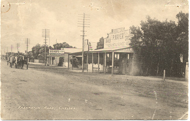 Chelsea & District Historical Society Inc
Photograph - Chelsea, Shops, c 1915
Black and white postcard of the main road, Chelsea (now Nepean Highway) showing P. Mayer's Store and Bishop's Store. Bishop's store is on the corner of Wimbourne Avenue, Chelsea. The road is unmade and two wagons are traveling down the road.Frankston Road, Chelseachelsea, mr p. mayer, mr bishop, wagons -
 Glen Eira Historical Society
Album - Album page, Grimwade House, Orrong Road, Circa 1972
This photograph is part of the Caulfield Historical Album 1972. This album was created in approximately 1972 as part of a project by the Caulfield Historical Society to assist in identifying buildings worthy of preservation. The album is related to a Survey the Caulfield Historical Society developed in collaboration with the National Trust of Australia (Victoria) and Caulfield City Council to identify historic buildings within the City of Caulfield that warranted the protection of a National Trust Classification. Principal photographer thought to be Trevor Hart, member of Caulfield Historical Society. Most photographs were taken between 1966-1972 with a small number of photographs being older and from unknown sources. All photographs are black and white except where stated, with 386 photographs over 198 pages. From Victorian Heritage Database citation HO54 Grimwade House, former Harleston stables, outbuilding, garden, gate and Picconia excelsa tree. https://vhd.heritagecouncil.vic.gov.au/places/35573 as at (28/10/2020) ''Harleston'', now "Grimwade House", is situated at no. 67 Balaclava Road, Caulfield North, at the Orrong Road corner. It was built for Frederick, later Sir Frederick, Grimwade, to the design of architect Thomas Watts in 1875. Today the complex has been incorporated in the Melbourne Grammar Junior School campus. It retains not only the main house but also the stables and mature garden setting with driveway and gates. It is historically, aesthetically and socially significant.From Victorian Heritage Database citation HO54 Grimwade House, former Harleston stables, outbuilding, garden, gate and Picconia excelsa tree. https://vhd.heritagecouncil.vic.gov.au/places/35573 as at (28/10/2020) It is historically significant (Criterion A) as the former home of prominent business man, speculator and benefactor, Sir Frederick Grimwade. Both Grimwade and his house are exemplars of the commercial enterprise of the Boom period and the amassing of personal fortunes with which it is associated. It is aesthetically significant (Criterion E) as an imposing yet stately large house of its time, the classic Italian form with comer verandah terminated by projecting wings being most distinctively seen in this instance. It is enhanced not only by the garden setting but also by the delicate cast iron verandah spandrels, stained glass work and stencilled ceiling in the music room. It is socially significant (Criterion G) on account of the value placed on it by the community associated with the Melbourne Grammar Junior School since its inception on this site in 1911.Page 154 of Photograph Album with five photographs (4 landscape and one portrait) including Grimwade House, gates and a tram shelter.Handwritten: Grimwade House (Melbourne Grammar Prep School) / incorporating "Harleston" Orrong Rd. S.E cnr Balaclava Rd [top right] / 154 [bottom right]trevor hart, verandah, porch, slate roof, garden, grimwade house, grimwade, harleston, sir frederick grimwade, thomas watts, orrong road, balaclava road, melbourne grammar, melbourne grammar junior school, italianate, cast iron verandah spandrels, stained glass, stencilled ceiling, mgs, m.g.s, school, grimwade family, jessie grimwade, gates, palisade style fence, cast iron spears, stone plinths, melbourne grammar prep school, victorian style, cast iron work, caulfield north, gardens, cars, tram services, outbuildings, stables, trees, picconia excelsa tree -
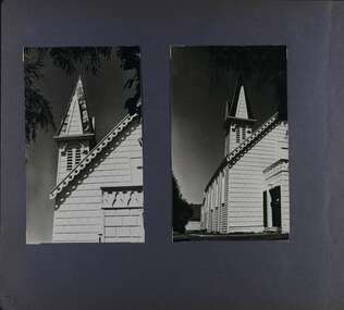 Glen Eira Historical Society
Album - Album page, Congregational Church, Grange Road, Circa 1972
This photograph is part of the Caulfield Historical Album 1972. This album was created in approximately 1972 as part of a project by the Caulfield Historical Society to assist in identifying buildings worthy of preservation. The album is related to a Survey the Caulfield Historical Society developed in collaboration with the National Trust of Australia (Victoria) and Caulfield City Council to identify historic buildings within the City of Caulfield that warranted the protection of a National Trust Classification. Principal photographer thought to be Trevor Hart, member of Caulfield Historical Society. Most photographs were taken between 1966-1972 with a small number of photographs being older and from unknown sources. All photographs are black and white except where stated, with 386 photographs over 198 pages. This church has since become the Greek Orthodox Church. From Victorian Heritage Database: Citation for Greek Orthodox Church HO84 https://vhd.heritagecouncil.vic.gov.au/places/43587 (as at 19/10/2020) The former Primitive Methodist, later Congregational, church at 152 Grange Road, Glen Huntly, is a small timber building, erected in 1885 (89?) in South Melbourne and relocated to Glenhuntly in 1909. It is a highly individual picturesque timber structure with distinctive spire and timber enrichment. It has aesthetic, historical and social significance. Its aesthetic value is derived from the choice of materials and picturesque Gothic Revival character showing American influence. Its historical value is derived from its survival as a rare example of a Primitive Methodist Church building whilst its social value hinges on its early roles as a place of worship for the Primitive Methodists in South Melbourne and the Congregationalists in Glenhuntly.Page 73 of Photograph Album with two photographs (both portrait) of front and side views of the spire of the Congregational Church on Grange RoadHand written: 73 [bottom left] trevor hart, congregational church, grange road, gothic revival, carnegie, glen huntly, glenhuntly, greek orthodox church, primitive methodist church, spire, timber buildings -
Whitehorse Historical Society Inc.
Newspaper - Article, Mitcham Road, Mitcham, 1/09/1993
Article on 476 Mitcham Road, Mitcham, built in 1958, for auction, 11 September 1993. Nunawading Gazette, 1 September 1993.mitcham road, mitcham, no. 476, auctions -
Whitehorse Historical Society Inc.
Newspaper - Article, 445-447 Mitcham Road, Mitcham, 4/04/1994
445 - 447 Mitcham Road, Mitcham, for sale by Robinson's Real Estate, 4 April 1994. 1920s house with potential for development.mitcham road, mitcham, nos. 445-447, real estate -
Whitehorse Historical Society Inc.
Pamphlet, Whitehorse Road, Blackburn, 1/08/1999
Whitehorse Road, Blackburn, No 73. Auction. Historical local landmark house built c1905. The house has many original features.whitehorse road, blackburn, auctions -
 Whitehorse Historical Society Inc.
Photograph, Deep Creek Road, 1/04/2001 12:00:00 AM
Coloured photograph looking from Schwerkolt Cottage Reserve across Deep Creek Road as work begins on construction of new Bridge.deep creek road, mitcham -
 Marysville & District Historical Society
Photograph (item) - Colour tinted photograph, Valentine Publishing Co. Pty. Ltd, The Road to Cumberland Valley, Marysville. No. 1, 1923-1963
An early colour tinted photograph of the intersection of the Buxton Marysville Road and the Marysville-Wood's Point Road.An early photograph of the Buxton Marysville Road and the Marysville-Wood's Point Road intersection. The Marysville-Buxton Road joins the Maroondah Highway which leads to Alexandra. The Marysville-Woods Point Road was originally part of the Yarra Track, constructed in the early 1860s to provide access between Healesville and the Woods Point Goldfields. Despite the steep terrain and engineering difficulties, the Yarra Track soon became a busy route used by pack horses, horse-drawn drays, and wagons. Today this sealed mountain road is a popular scenic drive between Marysville and Warburton. On the right of the photograph can be seen 'The Crossways Hotel' which is circa 1920 and one of the oldest buildings still standing in Marysville. 'The Crossways Hotel' survived the 2009 Black Saturday bushfires, through the efforts of the owner using buckets of water from the nearby Steavenson River. In the background can be seen the Poontawan Guest House which later became the Marysville Chalet Guest House which was on the site of the original Steavenson's Hotel. That guest house no longer exists and the Christ Church stands on the land where the guest house once stood. This photograph was published by the Valentine Publishing Co Pty. Ltd as a souvenir of Marysville.marysville, victoria, marysville chalet guest house, crossways hotel, christ church marysville, poontawan guest house, steavenson's hotel, valentine publishing co, souvenir, yarra track, wood's point road, mining, buxton-marysville road, marysville-wood's point road, maroondah highway, alexandra -
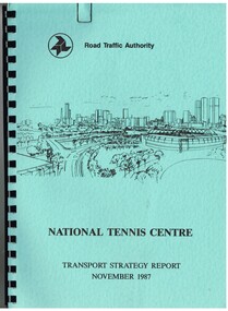 Melbourne Tram Museum
Document - Report, Dennis Johnston and Associates, Road Traffic Authority, "National Tennis Centre - Transport strategy Report November 1987", 1987
Report - 35 pages, within light blue covers, comb bound with black binder, titled "National Tennis Centre - Transport strategy Report November 1987". Report looks at the then planned Tennis Centre precinct and use of public transport in order to access it. It includes coach and car parking and how to handle various modes. Includes the MCG carpark, maps, parking areas, walking paths, access points. At the time, the tram line was located in Batman Ave. Also includes notes on the public information campaigns. Produced with the assistance of the MTA. Report prepared by Dennis Johnston and Associates for the Road Traffic Authority.trams, tramways, public transport, tennis centre, melbourne, mta -
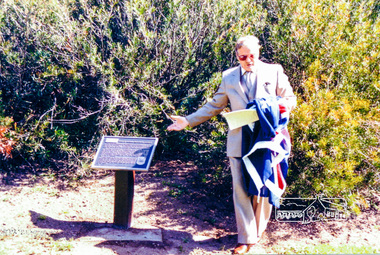
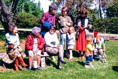
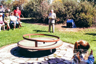 Eltham District Historical Society Inc
Photograph, Fitting of Time Capsule, Eltham, 1987, 1987
In November 1985 a monument was installed near the corner of Main Road and Pitt Street in Eltham, within the gardens at the front of what is now the Eltham Community and Reception Centre. This monument commemorates Victoria's 150th anniversary and the former location of the Eltham Town Centre, which existed along this section of Main Road, then known as Maria Street. Beneath the site is a time capsule to be opened in the year 2035. A plaque was also erected at this site in October 1987 to commemorate the Shire of Eltham Historical Society's 20th anniversary. The main feature of this monument is a ?tyring disc?, a blacksmith?s implement that was found on this site. This consists of a large iron disc that was used as a platform for fitting iron tyres (like the one shown on top of the platform) to wooden spoked cart wheels. The local blacksmith and wheelwright worked together to assemble the wheel, which was clamped to the platform placed close to the fire. The red hot iron hoop, previously forged to the correct size was lifted with tongs by the blacksmith over the outside of the rim, then hammered down amid flames from the scorching timber. The wheelwright drenched the tyre with cold water as soon as it was in position. A clamp placed on the naff (hub) and screwed down tightly kept the spokes at a constant angle as the tyre cooled. An even pressure from the contracting tyre tightened the joints at each end of the spokes and formed a vice-like grip, which would last for the life of the wheel.Colour photograph (one of four)eltham, joh ebeli, time capsule -
 Eltham District Historical Society Inc
Photograph, Fitting of Time Capsule, Eltham, 1987, 1987
In November 1985 a monument was installed near the corner of Main Road and Pitt Street in Eltham, within the gardens at the front of what is now the Eltham Community and Reception Centre. This monument commemorates Victoria's 150th anniversary and the former location of the Eltham Town Centre, which existed along this section of Main Road, then known as Maria Street. Beneath the site is a time capsule to be opened in the year 2035. A plaque was also erected at this site in October 1987 to commemorate the Shire of Eltham Historical Society's 20th anniversary. The main feature of this monument is a ?tyring disc?, a blacksmith?s implement that was found on this site. This consists of a large iron disc that was used as a platform for fitting iron tyres (like the one shown on top of the platform) to wooden spoked cart wheels. The local blacksmith and wheelwright worked together to assemble the wheel, which was clamped to the platform placed close to the fire. The red hot iron hoop, previously forged to the correct size was lifted with tongs by the blacksmith over the outside of the rim, then hammered down amid flames from the scorching timber. The wheelwright drenched the tyre with cold water as soon as it was in position. A clamp placed on the naff (hub) and screwed down tightly kept the spokes at a constant angle as the tyre cooled. An even pressure from the contracting tyre tightened the joints at each end of the spokes and formed a vice-like grip, which would last for the life of the wheel.Colour photograph (one of four)eltham, joh ebeli, time capsule