Showing 2519 items
matching melbourne water.
-
 Villa Alba Museum
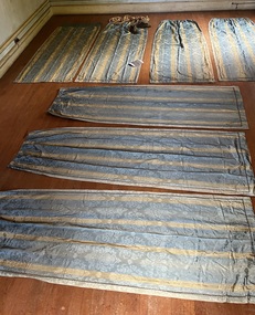
Decorative object - Suite of seven curtain panels, 1850s-90s
The curtains are significant for their comparative rarity of survival, and at the same time, are highly representative of opulent colonial taste in interior decor in the boom period. The curtain panels are of high quality materials and in unusually good condition, indicating they were used in a window with relatively little sunlight shining on them. They can be imagined in a grand room with one or more matching dressed windows.7 curtain panels, all the same size, possibly to fit a 3-light bay window; or alternately, to fit 3 windows in the same room (or something else altogether, if this is not the original total number of panels). Fabric: silk-wool mix, sky blue ground with narrow vertical gold stripes. The fabric is a damask weave with a watered (moiré) finish; the large, woven motif depicts an urn filled with stylised flowers, leaves and curlicues; the spacing of the motifs is more 19thC than older styles using much the same motif. Each curtain drop is decorated with an applied band of narrow, colour-matched gimp braid around the sides and lower end. The bottom hems are weighted with what feels like lead shot. The curtains are lined with sturdy brown cotton. They are gathered at the top edge on drawstring tape; and hand-sewn with small metal hanging rings. Faded vertical bands of sun exposure are visible on most of the curtains, and one panel has a mended tear on a lower side. Otherwise they are in excellent, sound condition.interior decoration-19th century, curtains-19th century, colonial taste-victoria, gold boom melbourne -
 Port Melbourne Historical & Preservation Society
Book, Weston Bate et al, Liardet's Water-colours of Early Melbourne, 1972
... Liardet's Water-colours of Early Melbourne...Weston BATE's 'Liardet's Water-colours of Early Melbourne... Australians Weston BATE's 'Liardet's Water-colours of Early Melbourne ...Purchased by member Peter LIBBIS from Pig's Wings Bookstore, who had it sent down from Sydney for usWeston BATE's 'Liardet's Water-colours of Early Melbourne' 101 pp with reproductions of forty Liardet paintings. MUP 1972wilbraham frederick evelyn liardet, wfe liardet, weston bate, susan adams, arts and entertainment, business and traders - hotels, built environment, natural environment, liardet family, emerald hill, st kilda, indigenous australians -
Port Melbourne Historical & Preservation Society
Book, Life on the bend, Jul 2017
"Life on the bend" Oblong book. Front cover photographs on blue background. Back cover blue with context logo.. Book explores 8 themes including industry, early settlement, identity ."Life on the bend" social history of Fishermans Bend Melbournebuilt environment - industrial, natural environment, fishermans bend -
 Department of Energy, Environment and Climate Action
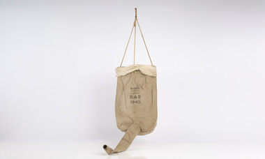
canvas water carry bag (large)
... makers Melbourne Canvas water bag with cover and outlet hose ...Used at bushfire base campsCanvas water bag with cover and outlet hose Dept of Defence 1946 GARS makers Melbourne forests commission victoria (fcv), camping equipment, bushfire -
Healesville Sanctuary Heritage Centre
Newspaper, The Sun News-Pictorial, Melbourne, 20 December 1955
Description of new platypuses. Photo of exterior and platypus in the wateroriginalnon-fictionDescription of new platypuses. Photo of exterior and platypus in the water1950s -
Healesville Sanctuary Heritage Centre
Newspaper, The Age, Melbourne, 20 December 1955
2 platypus moved into the new platypusery. Photo of platypus emerging from waterOriginalnon-fiction2 platypus moved into the new platypusery. Photo of platypus emerging from water 1950s -
 Federation University Art Collection
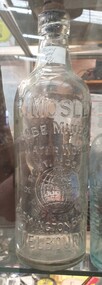
Photograph, R. Mosley Mineral Water Bottle
... Robert Mosely was an aerated water and cordial manufacturer ...Robert Mosely was an aerated water and cordial manufacturer. in 1909 Robert Mosley married Isabel Ethel Shepherd Stevens (or Steens). (Victorian Marriage Records, 1909) He died in 1936. MOSLEY. - On the 28th June at a private hospital, Melbourne, Robert, the dearly loved husband of Ethel Mosley, of 31 Ormond road, Moonee Ponds, loving father of Florrie (Mrs. Bayne), Jane, and Bessie (Mrs. Read), loving stepfather of Gladys (Mrs Myers) and Esma Campion, aged 75 years. — At rest. (The Argus, 29 June 1936) MOSLEY. — On the 28th June, at a private hospital, Melbourne, Robert Mosley, of 31 Ormond-road, Moonee Ponds. At rest. (The Age, 29 June 1936)Glass bottle made for Robert Mosely of Flemington Bridge, Melbourne. The 1896 Mosley bottles was manufactured in England and Victoria (t Mr Corfield's in Exhibition Street, Melbourne. )r. mosley, robert mosley, mineral water, flemington, globe mineral water works, flemington bridge -
 Warrnambool and District Historical Society Inc.
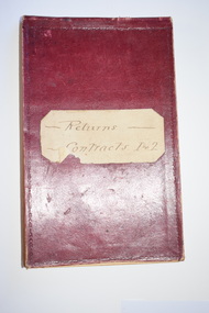
Administrative record - Warrnambool Water Trust Notebook, late 19th century (1892-1900)
This notebook appears to be the Warrnambool Water Trust Records of two contracts in 1892 . (The reference is written as 'W.W.Trust'.) The first contract, with the contractors, Coates and Reed, is for the excavation for settling tanks and clear water basin and a reservoir in Liebig Street and there are 60 pages giving details of these works - labour, masonry, concreting, fencing etc. The second contract with the contractor, William Kellas, is for the erection of a cottage and an engine shed and boiler room (7 pages). The Warrnambool Water Trust was set up in 1891 and the first project was the supply of water from the Merri River near Wollaston to a reservoir and tower in Liebig Street and this notebook concerns some details of this early water supply scheme. This notebook is of some interest as it supplies details of a late 19th century Warrnambool water supply scheme and so should be of value to local history researchers This is a notebook with a red leather cover and pages with printed headings and ruled red lines. The pages contain handwriting in black ink. The cover has a label (partly torn) with handwriting.Returns Contracts 1 & 2warrnambool water supply, warrnambool water board, 19th century water in warrnambool -
 Sunbury Family History and Heritage Society Inc.
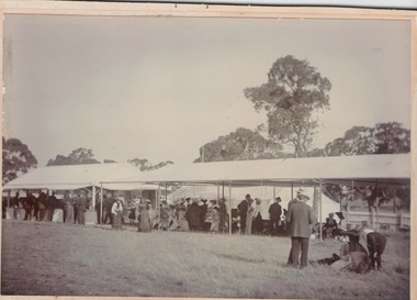
Photograph, Horse Racing, c1900 - 1910
The people in the photograph were enjoying a day out at a Sunbury race meeting some time in the early 1900s. Races at Sunbury began in 1886 with the establishment of the Sunbury Racecourse that was located along Racecourse Road on a section of the Rupertswood Estate on land consisting of six furlongs and two straights. The site included a patron’s stand, saddling paddock, bookmakers’ enclosure, two bars, a committee room, judges box, stables, toilets, six entrance gates and ticket boxes. Special trains from Melbourne brought patrons and horses to the Sunbury race meetings. A report in the Melbourne Argus newspaper in 1922, stated that city taxi drivers came out to Sunbury to drive patrons to the racecourse, which was located about 3 kms from the Sunbury station. Some time however, between 1886 and 1901, there was a period when the racing club had been inactive. A meeting was called in 1901 to restore the club’s activities. With a substantial loan from Mr. Clarke the committee was able to organise the installation of a turnstile, perimeter fencing and irrigation of the course by a windmill that pumped water from a recently constructed dam that was on the estate. The club continued to function until 1942, during World War 2, and did not resume activities after the end of the war. The land was eventually sold for housing development. The Sunbury Race meetings were popular with the racing fraternity not only in the district but further afield and were deemed sufficiently important to run special trains from Melbourne to Sunbury on Race days.A non-digital sepia photograph with a strong cardboard backing of a crowd of people dressed smartly for a day out at the races. Most of the spectators are seated in a long marquee. Three men on the RHS are looking at a horse that is lying on the ground.On the back of the card there are scribbled notes and numbers which seem to indicate the photograph has been used for a publication at some time.sunbury race meetings, sunbury race course, racecourse road -
 Wodonga & District Historical Society Inc
Photograph - Bethanga Bridge
The Bethanga Bridge was built between 1927 and 1930 as a joint venture between Victoria and New South Wales and was a key element of the River Murray Waters Agreement. It consists of nine spans of 82 metres long. Each span is supported between double reinforced concrete pylons and a riveted steel camel back Pratt truss. The overall span of the bridge is a length of 752 metres. It was completed in 1929 at a cost of £194,000. The road deck was initially constructed from timber but was replaced in 1961 with a concrete waffle slab deck 7.7metres wide. In 1961 the bridge deck and truss structure were raised 300 millimetres to allow for the enlargement of the lake. The bridge was designed in NSW by road engineer Percy Alan and the trusses were built by the Charles Ruwolt Pty. Ltd. Charles Ruwolt Pty. Ltd. was originally established by Charles Ruwolt as a foundry at Wangaratta in 1902 and transferred its operations to Richmond, Melbourne in 1914. By 1938 it had become one of the biggest engineering companies in Australia. After Charles Ruwolt’s death in 1946, Vickers Ltd. acquired the company and in 1948 the firm became known as Vickers Ruwolt Pty. Ltd. Because of the Bethanga Bridge’s unique location, over the waters of a dam with the border running down the centre of the body of water, the Bethanga Bridge is the only built structure shared by both Victoria and New South Wales. As the border of New South Wales aligns with the southern bank of the Murray River all of the other bridges along its length are deemed to be in New South Wales. The Bethanga Bridge is listed on both the New South Wales State Heritage Register and the Victorian Heritage Database. In 2015 the Bethanga Bridge was nominated for a heritage award by the Institution of Engineering Australia.These images are significant because they document the construction of a bridge which links Victoria and New South Wales and has been recognised for its historical, technical and engineering significance.A collection of photos documenting the construction of the Bethanga Bridge which links the States of Victoria and New South Wales as part of the construction of the Hume Dam .bethanga bridge, hume dam constuction, charles ruwolt, percy allan engineer -
University of Melbourne, Burnley Campus Archives
Newspaper - Newspaper Cutting, The Leader, Horticultural Notes, 1892
Copy of article in "The Leader" (Melbourne) 9 April 1892 p 10. Description of condition of Orchard after the earlier flood and finally water obtainable for irrigation.the leader, orchards, floods, irrigation, orchard -
University of Melbourne, Burnley Campus Archives
Newspaper - Newspaper Cutting, The Leader, Horticultural Notes, 1893
Copy of article in "The Leader" (Melbourne) on 7 January, 1893. Yan Yean water supplied to Burnley Gardens.the leader, yan yean, reservoir, irrigation, burnley gardens -
 Merri-bek City Council
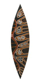
Oil on board, Maree Clarke, Fresh Water Shield (connection to country), 2007, 2007
... Merri-bek City Council 233 Sydney Road Brunswick melbourne ... -
 Merri-bek City Council
Archival pigment print, Stephanie Valentin, Still Water 1, 2011
... Merri-bek City Council 233 Sydney Road Brunswick melbourne ... -
 Merri-bek City Council
Photograph, Peta Clancy, Undercurrent, 2018-19
Peta Clancy is a descendent of the Bangerang people from South-Eastern Australia. She explores hidden histories of colonisation in Australia. Through manipulating photographic prints, she reconstructs these hidden histories in a contemporary setting. In 2018, Clancy was awarded the inaugural Fostering Koorie Art and Culture grant from the Koorie Heritage Trust. The grant enabled her to collaborate with the Dja Dja Wurrung community to create a body of work investigating massacre sites on Dja Dja Wurrung country. The exhibition Undercurrent at the Koorie Heritage Trust focussed on a massacre site submerged under water. Clancy says of the exhibition and this work: ‘I explored this site as a metaphor for the hidden history of many massacres throughout Australia and the denial of this aspect of our history and the trauma these sites evoke’. -
 Wodonga & District Historical Society Inc
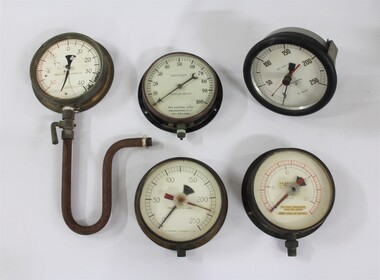
Functional object - Water Pump Pressure Gauges, North East Region Water Authority, Wodonga
The water pump pressure gauges were used by the Wodonga Waterworks Trust and Sewerage Authority, which were established in 1897, and had the responsibility for providing Wodonga's drinking water and managing the wastewater. In 1923 a Wodonga Waterworks Trust referendum to provide funding for new infrastructure to supply more water of better quality to Wodonga was passed. This included building the Wodonga Water Tower and it was completed in 1924. It supplied water to Wodonga until 1959, when it was drained and decommissioned after the No 1 Basin on Huon Hill was completed in 1958. In 1983 the Wodonga Waterworks Trust and the Wodonga Sewerage Authority became part of the Wodonga Council. By 1989 a filtration plant at Huon Hill was completed, which provided filtered water of improved quality to Wodonga, in accordance with the World Health Organisation’s guidelines. In 1994 the Kiewa Murray Region Water Authority took over the Wodonga Council’s water and wastewater operations, and then in 1999 the Kiewa Murray Region Water Authority combined with the Ovens Region Water Authority and became the North East Region Water Authority or NERWA. NERWA then became known as North East Water.The water pump pressure gauges have local significance due to their use by the Wodonga Waterworks Trust and Sewerage Authority, and donation from the North East Region Water Authority. They also have wider historical significance as examples of the equipment used in the management of water in Victoria and Australia.Five metal and glass water pump pressure gauges, including one with a U-shaped pipe and lever attached. "-HOMPSONS (CASTLEMAINE) LT-" on pressure gauge no.1 "BOURDON'S / PRESSURE GAUGE / THE AUSTRAL OTIS /ENGINEERING Co. LD. / MELBOURNE" on pressure gauge no.2 "No. 1609 / POUNDS PRESSURE / PER SQ. INCH / FEET HEAD OF WATER" on pressure gauge no. 3 "FEET HEAD OF WATER / THOMPSONS (CASTLEMAI-- LTD" on pressure gauge no. 4 "SET SLOW 33' -" / BUDENBERG / MADE IN AUSTRALIA / ft water / 1 4 9 3 9 each number underlined" on pressure gauge no. 5north east region water authority, nerwa, wodonga sewerage authority, north east water, n.e. water, wodonga waterworks trust, pressure gauges, water pump pressure gauges -
 Linton and District Historical Society Inc
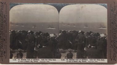
Stereograph, The Rose Stereographs, Melbourne, Sydney, Wellington and London, 12,826. The American Fleet in Australia, Copyright 1908
One of two sets of stereographs donated by the O'Beirne family along with a stereoscope for viewing (Stereoscope is Registration no. 2014-51).Stereographic image showing a ship from the American Fleet on the water in Port Phillip Bay."12,826. THE AMERICAN FLEET IN AUSTRALIA. Inside Port Phillip Heads, / en route to Hobson's Bay, Victoria."stereographs, american fleet -
 Merri-bek City Council
Acrylic on watercolour paper, Mandy Nicholson, Cultural Map of Melbourne, 2003
Primarily a painter, Mandy Nicholson also produces ceramics, carvings, murals, prints, designs and children’s clothing. Born in 1975, Nicholson was raised in Healesville and belongs to the Wurundjeri-willam (Woiwurrung language) clan of the Kulin Nation. Mandy’s paintings often represent important cultural rituals and are executed in her distinct graphic style using the traditional motifs of her people blended with contemporary interpretation. Cultural Map of Melbourne shows significant sites across Melbourne. These include scar trees, corroboree trees, stone quarries, bush tucker sites, significant rivers, fresh water wells and traditional campsites. -
 Flagstaff Hill Maritime Museum and Village
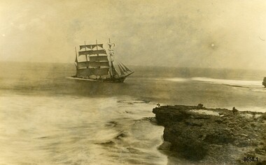
Postcard - Local Postcards, Joseph Jordan Photographic Studio, Nov 1908 - early 1909
ABOUT THE ‘FALLS OF HALLADALE’ (1886 - 1908) Built: in1886 by Russell & Co., Greenock shipyards, River Clyde, Scotland, UK. The company was founded in 1870 (or 1873) as a partnership between Joseph Russell (1834-1917), Anderson Rodger and William Todd Lithgow. During the period 1882-92 Russell & Co., they standardised designs, which sped up their building process so much that they were able to build 271 ships over that time. In 1886 they introduced a 3000 ton class of sailing vessel with auxiliary engines and brace halyard winches. In 1890 they broke the world output record. Owner: Falls Line, Wright, Breakenridge & Co, 111 Union Street, Glasgow, Scotland. Configuration: Four masted sailing ship; iron-hulled barque; iron masts, wire rigging, fore & aft lifting bridges. Size: Length 83.87m x Breadth 12.6m x Depth 7.23m, Gross tonnage 2085 ton Wrecked: the night of 14th November 1908, Curdies Inlet, Peterborough southwest Victoria Crew: 29 The Falls of Halladale was a four-masted sailing ship built-in 1886 in Glasgow, Scotland, for the long-distance cargo trade and was mostly used for Pacific grain trade. She was owned by Wright, Breakenridge & Co of Glasgow and was one of several Falls Line ships, all of which were named after waterfalls in Scotland. The lines flag was of red, blue and white vertical stripes. The Falls of Halladale had a sturdy construction built to carry maximum cargo and able to maintain full sail in heavy gales, one of the last of the ‘windjammers’ that sailed the Trade Route. She and her sister ship, the Falls of Garry, were the first ships in the world to include fore and aft lifting bridges. Previous to this, heavily loaded vessels could have heavy seas break along the full length of the deck, causing serious injury or even death to those on deck. The new, raised catwalk-type decking allowed the crew to move above the deck stormy conditions. This idea is still used today in the most modern tankers and cargo vessels and has proved to be an important step forward in the safety of men at sea. On 4th August 1908, with new sails, 29 crew, and 2800 tons of cargo, the Falls of Halladale left New York, bound for Melbourne and Sydney via the Cape of Good Hope. The cargo on board was valued at £35,000 and included 56,763 tiles of American slate roofing tiles (roof slates), 5,673 coils of barbed wire, 600 stoves, 500 sewing machines, 6,500 gallons of oil, 14,400 gallons of benzene, plumbing iron, 117 cases of crockery and glassware and many other manufactured items. The Falls of Halladale had been at sail for 102 days when, at 3 am on the night of 14th November 1908, under full sail in calm seas with a six knots breeze behind and misleading fog along the coast, the great vessel rose upon an ocean swell and settled on top of a submerged reef near Peterborough on south-west Victoria’s coast. The ship was jammed on the rocks and began filling with water. The crew launched the two lifeboats and all 29 crew landed safely on the beach over 4 miles away at the Bay of Islands. The postmistress at Peterborough, who kept a watch for vessels in distress, saw the stranding and sent out an alert to the local people. A rescue party went to the aid of the sailors and the Port Campbell rocket crew was dispatched, but the crew had all managed to reach shore safely by the time help arrived. The ship stayed in full sail on the rocky shelf for nearly two months, attracting hundreds of sightseers who watched her slowly disintegrate until the pounding seas and dynamiting by salvagers finally broke her back, and her remains disappeared back into deeper water. The valuable cargo was largely lost, despite two salvage attempts in 1908-09 and 1910. Further salvage operations were made from 1974-1986, during which time 22,000 slate tiles were recovered with the help of 14 oil drums to float them, plus personal artefacts, ship fittings, reams of paper and other items. The Court of Marine Inquiry in Melbourne ruled that the foundering of the ship was entirely due to Captain David Wood Thomson’s navigational error, not too technical failure of the Clyde-built ship. The shipwreck is a popular site for divers, about 300m offshore and in 3 – 15m of water. Some of the original cargo can be seen at the site, including pieces of roof slate and coils of barbed wire. These 5 postcards have photographic images taken while the Falls of Halladale was stuck on the reef near Peterborough. They are not stamped or dated but four of the images show the ship still in fairly good condition with her stern very low in the water so can be dated to around late November 1908 to January 1909 and the fifth image shows the ship beginning to disintegrate soon after. The image on Postcard 8658.3 was taken by Joseph Jordan (a well-known Warrnambool photographer who had his own studio in Liebig Street, Warrnambool). The other four images were supposedly taken by the sender (Bob) and converted to postcards. Amateur photography in Australia in the early 1900's was becoming very popular (and accessible) to the average person. Many newspapers published advertisements and articles about photography and photographic supplies. In 1903 in America, George Eastman designed and marketed the "Model 3A Folding Pocket Kodak" which used postcard-size negatives and provided the average person with a camera with which to make real photo postcards. As they became popular, George Eastman was able to develop and market a wide range of supplies for the amateur photographer to develop and print their own photographs onto a postcard backing at home. Four of the postcards were addressed to "Miss M. Kerr, Leura, Camperdown". Mary Agnes Kerr (1888 - 1943) was the daughter of William and Mary Ann Kerr (nee Spence) who owned "Leura Farm" at Camperdown. Mary Agnes Kerr went on to marry James Young Caldwell (a local tailor and mercer) in 1917. James Yong Caldwell came to Camperdown around 1908 and was employed as a draper. The postcards were signed "Bob". On postcard 5658.2 he has written his name with quotation marks around it - suggesting "Bob" is a nickname. He writes about the weather, meeting a friend, sending fish to Mary Agnes' family and the cargo expected to be washed up on the beach. On postcard 8658.4 he wrote about being busy after the wreck and supplying the shipwrecked crew with boots and pants which suggests "Bob" may be James Caldwell (the mercer and tailor).The Falls of Halladale shipwreck is listed on the Victorian Heritage Register (No. S255). She was one of the last ships to sail the Trade Routes. She is one of the first vessels to have fore and aft lifting bridges. She is an example of the remains of an International Cargo Ship and also represents aspects of Victoria’s shipping industry. The wreck is protected as a Historic Shipwreck under the Commonwealth Historic Shipwrecks Act (1976). These postcards are significant as examples of the continued interest the locals around the district of Peterborough showed towards the Falls of Halladale wreck and its disintegration during the next few months. Four of the postcards are also significant examples of the new hobby of photography that was available to the average person during the beginning of the 20th century.Set of 5 postcards showing different images of the Falls of Halladale sailing ship after it became stuck on a reef near Peterborough. None of the postcards are dated or stamped. Postcard 8658.1 has a sepia toned image of the Falls of Halladale, with its stern sitting very low in the water. It has many of its sails unfurled and there is a rocky headland in the foreground. A very small figure appears to be on the edge of the cliff. The back of the postcard has a handwritten message addressed to "Miss M Kerr, Leura, Camperdown" and is signed "Love Bob". Postcard 8658.2 has a sepia image of the Falls of Halladale taken some months after it had been stuck on the reef. Its sails are missing and only two broken masts remain. A large rock is visible in the front right hand side of the photo. There is a handwritten message on the back signed by "Bob". Postcard 8658.3 has a black and white image of the Falls of Halladale showing her almost side on with her stern very low in the water and still in full sail. The words "Falls of Halladale. No 1" are printed on the lower left side of the image. The back is labelled "Jordan Series". There is no message written on the back. Postcard 8658.4 has a sepia toned image of the Falls of Halladale facing two rocky headlands. She is showing full sail and the sea appears calm. There is a handwritten note on the back addressed to "Miss M Kerr" from "Bob". Postcard 8658.5 has a sepia image of a side view of the Falls of Halladale with her stern very low in the water and her sails are all up. The sea is calm and a rocky reef can be seen in the foreground. It has a handwritten note on the back from "Bob" to "Miss M Kerr" of Leura, Camperdown.Back of postcard 8658.1- "POST" "EMPIRE" "CARD" "FOR CORRESPONDENCE" "FOR ADDRESS ONLY" "STAMP" "Miss M Kerr / Leura / Camperdown" "Looking forward to letter today" "Hope fish arrived / allright. Don't / know for sure / what day I will / be going to Town / to buy. Some day / this week / Love Bob Back of postcard 8658.2 - "POST CARD"/ "CORRESPONDENCE" "ADDRESS ONLY" "93"/ "Friday / This is a contrast to the first/ I sent you. Having glorious weather / Saw Saw (Saul)? on Thursday at Peterborough / He is having a grand holiday / Expecting letter on /Tuesday Fondest Love / "Bob" Front of postcard 8658.3 - "Falls of Halladale. No 1" Back of postcard 8658.3 -"Post" "Card"/ Printed in Great Britain" /"This space may be used for Communication" "The Address to be written / here" "Jordan Series" Back of postcard 8658.4 -"POST" "EMPIRE" "CARD"/ "FOR CORRESPONDENCE" "FOR ADDRESS ONLY" / "STAMP" "Miss M Kerr/ Leura / Camperdown"/ "We are/ very busy. The / wreck is about / 11/2 other side of / Peterborough./ Fondest Love, Bob "Had to supply sailors with Boots Pants etc/ 25 pairs Boots, good order ah!" Back of postcard 8658.5 - "POST" "EMPIRE" "CARD" / "FOR CORRESPONDENCE" "FOR ADDRESS ONLY" / "STAMP"/ "Miss M Kerr / Leura / Camperdown" "Tuesday / Her estimated / value cargo included/ is (pounds)100,000. When / she breaks up the coast / will be strewn with / wreckage as the cargo / includes Rolls Paper./all sorts machinery thousands / cases Benzine etc/ love Bob flagstaff hill maritime museum and village, warrnambool, peterborough, great ocean road, falls of halladale, shipwreck, postcards, photographic images, mary agnes kerr, leura farm, camperdown, jordan series, handwritten notes, photographs, george eastman, 3a folding pocket kodak camera -
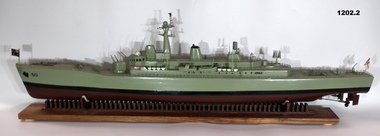 Bendigo Military Museum
Craft - MODEL & BASE, HMAS SWAN
Model of HMAS Swan built by Shipwright Charles Axiak. Original ship construction in Melbourne and entered service 1970. Was a River Class Destroyer. Model maker worked in British Dockyards during WW2 and emigrated to Australia in 1955. He worked in Williamstown dockyards involved with construction of the Swan,1. Model of River Class Destroyer. green in colour from water line. Black line and brown at bottom. Small Australian flag at front and naval flag at back. 2. Wooden stand, tailor made to hold the model of the 'Swan'. Brown in colour with long flat board and separate pieces of wood embedded in the base to make the cradle. High points of cradle covered by some white felt to protect boat. Bottom of stand has felt studs."50" painted at front of boat.ships model, hmas swan -
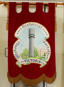 Wodonga & District Historical Society Inc
Banner - Wodonga Historical Society Banner, Betty L. Barberis, 2009
This item was created for Wodonga Historical Society by the artist, Betty L. Barberis in 2009. Betty Barberis nee Barton was one of 12 children born to Roderick Barton and Myrtle Ann Hore of Gundowring in the Kiewa Valley. She was born in 1927 and attended Upper Gundowring Primary School. Betty was encouraged to enter a project for the "Young Farmers" by illustrating a book. She won first prize for Victoria and the book was exhibited at the Royal Melbourne Show. This resulted in Betty attaining a Manual Art Teacher's Studentship which she completed at Wangaratta Technical School. Here she learned many new skills ranging from garment design to ceramics. She also attended Melbourne Teachers College. Betty created many decorative banners, the first being for the Australian section of the World Scout Jamboree in 1948. Over her long career she was to create many other banners and commissioned work, including this banner created for Wodonga Historical Society and featuring the Wodonga Water Tower. Betty’s great body of work included landscapes, millinery, ceramics, and a bronze sculpture of her husband Vern Barberis who was a fellow schoolteacher and represented Australia as a weightlifter, winning a bronze medal at the Helsinki Olympics in 1952. She also illustrated several books and had exhibitions in many galleries including in Albury. Betty passed away at The Grange, Wodonga on 26 November 2013.This banner was created by a renowned and highly regarded artist from Northeast Victoria.A large velvet banner created for the Wodonga Historical Society by noted local artist Betty L. Barberis. It is mounted on a pine rod and features an image of the water tower in Wodonga, Victoria. The majority of the banner is hand stitched.Around the edge of the central image: "Wodonga Historical Society Victoria.wodonga historical society, betty l. barberis -
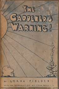 Hymettus Cottage & Garden Ballarat
Work on paper - Book, The Gardener's Warning
A small book of 47 pages printed at The Specialty Press Melbourne. Covers in poor condition due to wear and water but content pages fair although cover now detached.fictionedna walling, gardeners, poetry -
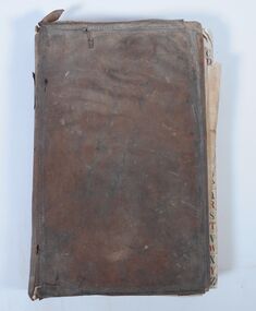 Bendigo Historical Society Inc.
Administrative record - Account Book, 1859
The purchases and services recorded indicate that the user was an ironmonger. Origin of ledger unknown. Early business in Sandhurst in 1860s.An account ledger used to record the purchases and services made for a business. Records date from 1860. The ledger is covered with brown leather with decorative edges. There are alphabetical tabs at the front of the book with lists of names. Individual customers are allocated a double page entry. Pages are ruled and numbered. The book is in very poor condition having obvious signs of water and insect damage. The writing in the first quarter of the book is barely legible, remaining pages can be read. Some names - Durant, Watson, Mollison, Harris, Neale, Cahley, Bannerman, Larritt, Cranshaw, Gripe, McLachlan, Burrell, O'Loughlin, Cameron Rogers, McLevey, Nicholas Eliad?, Crago, Hopsell, Grant, Bird, Cahill, Harker, Parker S McKinlay, Fletcher, Birch, Cruikshank, Municipal Council, Heffernan and Crawley, Buckley Bros, John Harney, Bywater and Brother, Goulding, Casey, Reynolds, English, McKenzie, Knight, David Mackay."LEDGER" on the spine. Label inside "Sands and Kenny. Account Book Manufacturers. Stationers and Printers Melbourne"bendigo businesses, ironmonger -
 Eltham District Historical Society Inc
Photograph - Digital Photograph, Alan King, Pigeon Bank, Kangaroo Ground-Warrandyte Road, Kangaroo Ground, 6 February 2008
In 1848, Francis Rogerson form Dumfriesshire, Scotland purchased 80 acres of land at Kangaroo Ground on which he built a two-roomed bark hut. He named the property afterr the many Bronzewings and Wonga Pigeons in the area. Ewen Hugh Cameron moved to Pigeon Bank the same year he was elected to Parliament as the Member for Evelyn. At the time he moved in, Pigeon Bank had six rooms and the present water well. He made further extensive additions and lived there until his death in 1915. Covered under Heritage Overlay, Nillumbik Planning Scheme. Published: Nillumbik Now and Then / Marguerite Marshall 2008; photographs Alan King with Marguerite Marshall.; p27 Pigeon Bank, on the Kangaroo Ground – Warrandyte Road, Kangaroo Ground, is one of the Shire’s oldest farm dwellings, and has been home to some of the district’s earliest and most distinguished families. Although close to the road, the white weatherboard Victorian farmhouse is ensured privacy by the trees and hedges around it. On 4.8 hectares of farmland, Pigeon Bank is surrounded by rolling hills, farmland and bush, the peace of which is punctuated by an occasional birdcall. Pigeon Bank’s first owner was Francis Rogerson, from Dumfriesshire, Scotland, who bought 80 acres (32.4ha) of land in 1848 on which he built a two-roomed bark hut. Today this is the centre piece of the 14-room home.1 Rogerson lined the rooms with tongue-and-groove boards and roofed them with wooden shingles and sapling frames, which remain under the present green corrugated iron roof. He named Pigeon Bank after the many forest bronzewing and Wonga Pigeons in the area at the time, and the name Bank was commonly used in Scotland. Rogerson was united with one of the oldest families in the area when his sister Janet married John Bell, son of William, the original Bell settler. When Ewen Cameron moved to Pigeon Bank in 1874 it had six rooms and the present water well. He made extensive additions to the house and farm buildings and lived at Pigeon Bank until his death in 1915. Cameron, who had arrived in Melbourne from Scotland in 1853, contributed an enormous amount to the community. He worked as a builder, as a miner at Andersons Creek, a storekeeper at Queenstown2 and as the first postmaster at Warrandyte. In 1867 he married Agnes Bell, daughter of local farmer, John Bell. Cameron was a member of the Eltham Road Board (which preceded the Shire Council) and for more than 50 years, from 1863, he was an Eltham Shire Councillor, being President three times. Cameron was the Member for Evelyn for 40 years from 1874. In the 1880s he became the Government Whip, in 1902 the Minister for Mines and Water Supply, and in 1904, the Minister for Health, Cameron was also an outstanding farmer, whose farm won the Agricultural Department prize for the finest in the district, three consecutive times. Not surprisingly Pigeon Bank became the centre of district life. Every New Year’s Eve, Cameron hired a highland piper, who marched from the Kangaroo Ground school house to Pigeon Bank playing his pipes.3 Distinguished visitors included opera singer, Dame Nellie Melba, Victorian Premier, Thomas Bent, Governor, Lord Hopetoun and artist, Longstaff. Following Cameron’s death, the property changed hands several times, then returned to the family in 1919 when bought by Gordon Cameron. As the car took over from the horse, Pigeon Bank entered difficult times because the farm had produced chaff and oats and bred Clydesdales and harness ponies. In 1926 Mr Matthews bought the property and made many alterations including pulling down the kitchen, which had been separate from the main house. The property again changed hands several times. One owner was Senator James F Guthrie, who added a sunroom. In 1968 the house again returned to the Cameron family, when Vera Jackson, a grand-daughter of Ewen Cameron, and her husband, bought the property. The Bishop family, who were sixth and seventh generation Bells and also descended from the Camerons, restored the house in the 1980s. Today tongue-and-groove boards still line part of the hall (which retains two fine arches), the breakfast room, and Ewen Cameron’s former room. Five original fireplaces in the bed and living rooms are still in working order. The wide veranda with a curved iron roof and ornate iron lace work bounds three sides of the house, and nearby a windmill stands beside the water well. Sue and Ron James, who bought the property in 2001, made extensive improvements to the homestead and meticulously restored the grounds to their original state.This collection of almost 130 photos about places and people within the Shire of Nillumbik, an urban and rural municipality in Melbourne's north, contributes to an understanding of the history of the Shire. Published in 2008 immediately prior to the Black Saturday bushfires of February 7, 2009, it documents sites that were impacted, and in some cases destroyed by the fires. It includes photographs taken especially for the publication, creating a unique time capsule representing the Shire in the early 21st century. It remains the most recent comprehenesive publication devoted to the Shire's history connecting local residents to the past. nillumbik now and then (marshall-king) collection, ewen hugh cameron, francis rogerson, kangaroo ground, kangaroo ground-warrandyte road, pigeon bank -
 Eltham District Historical Society Inc
Photograph - Digital Photograph, Alan King, Site of the Diamond Creek Gold Mine, 28 December 2007
The largest gold mine in the area originated from a find in 1862. The mine was closed January 20, 1915 when a fire destroyed nearly all the above ground plant. Published: Nillumbik Now and Then / Marguerite Marshall 2008; photographs Alan King with Marguerite Marshall.; p75 Beneath Mine Hill, as locals call it, runs a network of tunnels once of central importance to the fledgling township of Diamond Creek. These are relics of gold mines, which transformed early Diamond Creek.1 The tiny settlement of about 20 families soared to more than 200 because of gold. For around 50 years, from 1862, gold mining was Diamond Creek’s major source of employment. On September 7, 1854 The Argus newspaper reported a find of a four pound (1.8kg) gold nugget in Nillumbik (an early name for Diamond Creek). Exactly where, is not known.2 The largest mine in the district, the Diamond Creek Gold Mine, apparently originated from a find in 1862. It is said Joe and Dave Wilson were visiting former tailor then cook, Charles Orme, at the southern end of Fraser Street. Sitting on a stump outside the front gate on land belonging to Dr A. E. Phipps the Wilsons found a vein of gold-bearing quartz, which led to the discovery of four quartz reefs varying in width to eight inches (20cm), running north and south. A reef found at the foot of the hill opposite Challenger Street became the Union Mine. This reef was traced south to Allendale Road where a small mine began operations.3 Other smaller mines later operated as well. Dr Phipps immediately began to mine and also built the Diamond Reef Hotel as a boarding house for miners. But Charles Orme, who owned the land alongside, leased his mine to Dr Phipps probably because of insufficient funds and business skills. By mid 1865 the mine had produced 2530 ounces of gold – a 100% profit on the original outlay. Of course there were problems. When the local dam dried up a Blake pump was installed to draw water from the creek. The Union Mine operated under the Diamond Creek Gold Mine management except when disputes sometimes resulted in separate management. However disagreements had to be resolved as the Union Mine depended on Diamond Creek Gold Mine pumps to remove underground water from common reefs. In 1912 the main shaft of about 380 yards (350m) employed 200 men recovering an average of 5000 ounces (141.7kg) of gold a year. But not everyone did well out of gold. Records of failed mining companies in the Victorian Public Record Office, reveal that owner Dr Phipps leased his Right to others. Companies came and went over the next 40 years, most sponsored by Melbourne businessmen who sold shares to gullible locals and then became insolvent. Although there were some good profits, financial returns were haphazard until 1905. Some local residents, who were share holders in short- term companies, became well-known names in modern Diamond Creek such as Scott, Haley, Butler, Alder, Ryan, Wadeson, Reeves, Alston, Paul and Edwards. Gold mining was brought to a disastrous end on January 20, 1915 at 3 pm, when fire destroyed nearly all the above-ground plant. Fortunately no lives were lost. But reopening the mine was almost impossible because of the increasing depth of water in the main shaft. The closed mine destroyed the livelihood of 200 families and the debris took many years to clear.4 In 1946 the Diamond Creek Gold Mine was reopened by the Golden Hind Mining Company, but money ran out before the 600 feet (182.8m) or so of water could be removed. Gold remains in the mine but enormous capital would be needed to buy the land, equipment and to remove the water. Today 12 known sealed shafts along the ridge of the hills on private property extend west for around one kilometre from the corner of Fraser and Haley Streets, crossing Norma and Fyffe to Dering Streets. As recently as 1987, heavy rains revealed a former Union Mine shaft in the Georgiadis family Fyffe Street back yard.5 Allendale Mine, south of Allendale Road, is still open and one of the Union Mine’s main drives (horizontal excavation) remains unsealed, on the Creek Reserve.This collection of almost 130 photos about places and people within the Shire of Nillumbik, an urban and rural municipality in Melbourne's north, contributes to an understanding of the history of the Shire. Published in 2008 immediately prior to the Black Saturday bushfires of February 7, 2009, it documents sites that were impacted, and in some cases destroyed by the fires. It includes photographs taken especially for the publication, creating a unique time capsule representing the Shire in the early 21st century. It remains the most recent comprehenesive publication devoted to the Shire's history connecting local residents to the past. nillumbik now and then (marshall-king) collection, diamond creek, diamond creek mine, fraser street, gold mining, james cook drive, mine hill -
 Eltham District Historical Society Inc
Photograph - Digital Photograph, Alan King, Ellis Cottage, Diamond Creek, 23 January 2008
Built by William Ellis in 1865 of local uncut stone about 30cm thick, the cottage is now a museum and home to the Nillumbik Historical Society. Ellis Cottage is historically significant for its association with the Ellis family, who were pioneers of the Diamond Creek district and the benefactors of the notable Nillumbik Cemetery gateway. It illustrates the development of farming in the area. Ellis Cottage is historically and technically significant for its rare use of uncut local stone for building purposes. Covered under Heritage Overlay, Nillumbik Planning Scheme. National Estate Published: Nillumbik Now and Then / Marguerite Marshall 2008; photographs Alan King with Marguerite Marshall.; p79 Ellis Cottage, built by William Ellis, is a memorial to the courage of pioneers in the Diamond Valley area.1 Now a museum and home to the Nillumbik Historical Society, it is a fine example of an early settler’s house in Diamond Creek – and one of the few original buildings standing from the middle of the 19th century. It is a poor man’s cottage – typical of the dwellings of those who had to work hard to wrest a living in this district, because most of the land was not fertile enough for major forms of farming. The pretty stone cottage at 10 Nillumbik Square, built in 1865, is made of local uncut stone about one foot (30 cm) thick. It once stood near the centre of the 147 acres (59.4ha) Ellis bought in 1850. The property extended from Diamond Creek to Reynolds Road and from Perversi Avenue to the Wattle Glen School. It stood in the electoral parish of Nillumbik. The Nillumbik township (later called Diamond Creek) was not created until 1867. In 1912 the property was cut in half by the new railway to Hurstbridge. Ellis paid £147/10/- for the land - about three times what a Victorian farmer would usually earn in a year. Despite the poor quality soil Ellis became a very successful farmer with an orchard, vegetables and a dairy herd. Five years later, in 1855, Ellis bought 70 acres (28.3ha) from neighbour, Hugh Larimour. In 1857 Ellis bought 208 acres (84ha) at Yarra Glen. In 1877 he bought 122 acres (49.3ha) at Diamond Creek and later bought land at Greensborough and Woodstock. Ellis was born in 1815 at Blackawton, a small Devonshire village, and became a tenant farmer. It is not known why Ellis came out to Australia or settled in Diamond Creek. In 1847 he married Margaret Child at the Melbourne Presbyterian Church. Ellis and Child had no children and 18 years after the wedding, while probably living in Kangaroo Ground, Ellis built this small cottage. The simple cottage has a central hall and two rooms on each side. To maximise the small space the ceiling cavity was designed large enough to provide sleeping accommodation accessed via a ladder. Each room was heated by an open fireplace and the one in the kitchen was large enough to roast a sheep. A large cellar under the front room probably stored farm produce. Water came from a well as reticulated water did not arrive at Diamond Creek until 1914. In 1870 Ellis’ 22 year-old nephew Nathaniel joined him from England.2 Until 1890 they developed Ellis Park, praised in The Evelyn Observer, May 30,1890 as a model farm. Ellis had become wealthy, and on his death in 1896 his estate was valued at £9000. In his will he left £100 to construct memorial gates at the Nillumbik Cemetery where he was buried.3 Ellis left the farm to his second wife Louisa. As he had no children, upon her death the farm passed to Nathaniel, but he did not take it up. The farm was sold and leased several times until 1967, when engineer Phillip Lovitt bought the property and carried out major structural works. The Shire of Diamond Valley bought it in the 1980s and in 1989 restored it with the Nillumbik Historical Society. The stone walls of the cottage had been plastered with mud and straw mortar, which were removed as they were riddled with vermin. Doors, windows and a floor were replaced and the original roof of timber shingles had been replaced with slate. The well was too deeply cracked to be restored, so was used for a flower bed. Two mature Italian Cypresses at the entry are also heritage protected as they relate to similar trees planted at Shillinglaw Cottage and other early buildings in Nillumbik Shire.This collection of almost 130 photos about places and people within the Shire of Nillumbik, an urban and rural municipality in Melbourne's north, contributes to an understanding of the history of the Shire. Published in 2008 immediately prior to the Black Saturday bushfires of February 7, 2009, it documents sites that were impacted, and in some cases destroyed by the fires. It includes photographs taken especially for the publication, creating a unique time capsule representing the Shire in the early 21st century. It remains the most recent comprehenesive publication devoted to the Shire's history connecting local residents to the past. nillumbik now and then (marshall-king) collection, ellis cottage, diamond creek, nillumbik historical society, william ellis -
 Eltham District Historical Society Inc
Photograph - Digital Photograph, Alan King, Edendale Farm Homestead, 29 January 2008
Edendale Farm is Nillumbik Shire Council's environment centre situated in Gastons Road, Eltham between the railway and the Diamond Creek. The homestead on the property was built in 1896 and is of historical significance, being the subject of a Heritage Overlay under the Nillumbik Planning Scheme. The Edendale property was originally part of an extensive land purchase in 1852 from the Crown by pioneer Eltham farmer Henry Stooke. He initially purchased 51 acres and later expanded his holdings by purchasing another three adjacent Crown allotments extending northerly from Josiah Holloway's Little Eltham subdivision. Despite clearing the land, Stooke did not build on this property, choosing to live on his property "Rosehill" at Lower Plenty. In 1896 Thomas Cool, Club Manager of the Victoria Coffee Palace in Melbourne purchased 7 acres of the original Stooke land and built the house now known as Edendale. Cool did not farm the land, instead using it as a gentleman’s residence, retiring to Eltham at weekends. In 1918 he purchased an additional 7 acres but in 1919 he sold the property. Later owners included J.W. Cox, the Gaston family and D. Mummery. In the 1980s the Eltham Shire Council purchased the site for use as a Council depot, but this use did not proceed. Subsequently, it was used as the Council pound. The Edendale Farm Pet Education and Retention Centre was established in the summer of 1988/1989 and was set up to replace the existing dog kennels with a high standard pet retention centre. The design style of the building was established to compliment the features of the existing house. It was equipped with 10 retention pens, a veterinary room and a pet education area where school children and other interested parties learnt about pet care procedures. It was later developed into a community farm and was run by an advisory committee and in 2000 it became an Environment Centre. In early 2006 an advisory committee was established for the development of a master plan for future development at Edendale Farm. The committee included Russell Yeoman, a former long-time shire planner and founding member of the Eltham District Historical Society. At the time of filming the Master Plan and future for Edendale was about continuing to develop Edendale as a centre of environment learning and looking at expanding displays and school program, running a lot more of life-long learning and workshops around sustainable living. Covered under Heritage Overlay, Nillumbik Planning Scheme. Published: Nillumbik Now and Then / Marguerite Marshall 2008; photographs Alan King with Marguerite Marshall.; p101 A sharp turn from busy Wattletree Road by the railway line, brings a surprise. Only 1.4 km from Eltham’s centre, sheep feed, blissfully unaware of the hectic suburban activity so close by. At the entrance to the 5.6ha Edendale Farm is another surprise. A work of art that looks like huge tree trunks transformed into bowler and top-hatted men. The Fences Act 1968 by Tony Trembath with Mark Cain and John Doyle, 1996, is classified by the National Trust of Australia as having Regional Significance. The title refers to a government act on disputes between neighbors over the placement of fences and boundaries. This takes a ‘wry swipe’ at a community divided by trivial squabbles. It also celebrates making do with limited resources.1 Further along on the left, the office wall is decorated with a massive Eltham Copper Butterfly, designed by Robert Tickner and made by school children with used plastic bottles and other waste material. Nillumbik Council runs Edendale as an Environmental Education Centre, to help preserve and enhance the local environment. As early as 1988 the former Eltham Shire Council realised Edendale’s importance in meeting people’s needs, particularly of children, to enjoy farmland. The centre, with the Eltham North Reserve to the north - including remnant bushland and open parkland - makes up the major part of the public open space for this area. The council considers this area will become increasingly important to the local community for recreational use.2 Educational programs aim to encourage community involvement to ensure the long-term rehabilitation and protection of natural bushland areas. Edendale is used by people of all ages - from school children to adults - for environmental programs and workshops, as well as for recreation, to enjoy the domestic animals and to picnic. Edendale is also home to the Environmental Works staff who manage reserves and roadsides and support Nillumbik Friends environmental groups. The Friends propagate plants at the nursery, which grows indigenous plants and sells these to the public.3 The centre demonstrates the sustainable living the farm teaches, with features like solar hot water and drive lighting and for the fireplace, logs of recycled cardboard. Edendale has had a varied history as a dog pound and even as a retreat for Thomas Cool, Club Manager of the Victoria Coffee Palace in Melbourne. His single-storey weatherboard house built in 1896, which still stands, was grander than most homes in Eltham. Although such buildings were common in many other parts of Melbourne, Eltham’s poverty and remoteness did not encourage such construction. The Victorian rectangular-shaped house, with a corrugated iron roof and veranda, has elegant large rooms, leadlight windows, ceiling roses, two bay windows and ornately carved wooden fireplace surrounds. Cool bought seven acres (2.8ha) from pioneer Eltham farmer Henry Stooke’s 200 acre (81ha) farm, which he had bought from the Crown in 1852. In 1918 Cool bought an extra seven acres (2.8ha) but in 1919 sold the estate to farmer John Cox. In 1933 Cox sold Edendale to Mrs Elizabeth Gaston, after whom the road leading to the centre was named. The property was owned by several Gaston family members, who called it Edendale, then by a police constable, Douglas Mummery, until the Shire of Eltham bought it in 1970. Oddly Edendale was known as Mummery’s for almost 20 years, although Mummery owned it only for a short time.4 The shire used Edendale as a dog pound until amalgamation with other municipalities in 1996. The pound then moved to the Yan Yean Road, Plenty site, which had been used by the former Diamond Valley Shire Council. To the west and north the centre is bounded by Diamond Creek and on the east by the Melbourne-Hurstbridge railway line. Part of the Research creek forms the centre’s southern boundary.This collection of almost 130 photos about places and people within the Shire of Nillumbik, an urban and rural municipality in Melbourne's north, contributes to an understanding of the history of the Shire. Published in 2008 immediately prior to the Black Saturday bushfires of February 7, 2009, it documents sites that were impacted, and in some cases destroyed by the fires. It includes photographs taken especially for the publication, creating a unique time capsule representing the Shire in the early 21st century. It remains the most recent comprehenesive publication devoted to the Shire's history connecting local residents to the past. nillumbik now and then (marshall-king) collection, edendale farm -
 Eltham District Historical Society Inc
Photograph - Digital Photograph, Alan King, The Robins, 13 Kangaroo Ground-Warrandyte Road, North Warrandyte, 2 March 2008
Built by noted artist Theodore Penleigh Boyd, father of architect Robin Boyd. Covered under National Estate, National Trust of Australia (Victoria) Local Significance and Heritage Overlay, Nillumbik Planning Scheme. Published: Nillumbik Now and Then / Marguerite Marshall 2008; photographs Alan King with Marguerite Marshall.; p111 The Robins at Warrandyte,* was once home to a member of a famous family and is also one of the first reinforced concrete houses in Victoria. The builder, Theodore Penleigh Boyd, born in 1890, was a talented painter1 noted for his works of the Warrandyte bush. He was the father of architect Robin Boyd, author of the Australian Ugliness and the uncle of painter, Arthur Boyd. Penleigh Boyd’s great grandfather was Sir William A’Beckett, Victoria’s first Chief Justice. Penleigh Boyd is considered by some to be an ‘unsung hero’ overshadowed by more famous members of his family. Mornington Gallery Director Andrea May said many believed Boyd ‘had never received the national acclaim that he deserved’.2 Classified by the National Trust3 and part of the Australian National Heritage,4 The Robins is set well back near the end of Kangaroo Ground – Warrandyte Road, unobserved by passers-by. Built in 1913, The Robins has some Art Nouveau influences and is a descendant of the Queen Anne style. It is covered in stucco and has a prominent attic, which Boyd used as a studio. Some parts of the house are up to 33 centimetres thick and built in part with pisé (rammed earth) and in part with reinforced concrete. Amazingly, Boyd built The Robins without an accessible driveway, and only a narrow track along which he had to cart building materials. The journey was uphill and Boyd terraced the land with Warrandyte rock5 without the aid of machinery. At only 33 years, Boyd was killed in a car accident in 1923. He was buried in Brighton near the home of his parents. Several people have since owned the house, including political journalist, Owen Webster. Boyd was born at Penleigh House, Wiltshire, and studied at Haileybury College, Melbourne and The Hutchins School, Hobart. He attended the Melbourne National Gallery School and in his final year exhibited at the Victorian Artists’ Society. He arrived in London in 1911 and his painting Springtime was hung at the Royal Academy. He painted in several studios in England and then worked in Paris.6 There he met painter Phillips Fox through whom he met artists of the French modern school and also his wife-to-be, Edith Anderson, whom he married in Paris in 1912. After touring France and Italy, the couple returned to Melbourne. In 1913 Boyd held an exhibition and won second prize in the Federal Capital site competition, then the Wynne Prize for landscape in 1914. In 1915 Boyd joined the Australian Imperial Force, and became a sergeant in the Electrical and Mechanical Mining Company. However he was severely gassed at Ypres and invalided to England. In 1918 in London Boyd published Salvage, writing the text and illustrating it with 20 black-and-white ink-sketches of army scenes. Later that year he returned to Melbourne, and, despite suffering from the effects of gas, he held several successful one-man shows, quickly selling his water-colour and oil paintings. In his short career Penleigh Boyd was recognized as one of Australia’s finest landscape painters. He loved colour, having been influenced early by Turner and McCubbin. His works are in all Australian state galleries, the National Collection in Canberra as well as in regional galleries.7 His wife Edith was also an artist having studied at the Slade School, London, and in Paris with Phillips Fox. After her marriage she continued to paint and excelled in drawing. In later years she wrote several dramas, staged by repertory companies, and radio plays for the Australian Broadcasting Commission, in which she took part. She was the model for the beautiful red-haired woman in several of Phillips Fox’s paintings and the family hold three of his portraits of her. *Possibly named after the Aboriginal words warran, meaning ‘object’ and dyte, meaning ‘thrown at’.This collection of almost 130 photos about places and people within the Shire of Nillumbik, an urban and rural municipality in Melbourne's north, contributes to an understanding of the history of the Shire. Published in 2008 immediately prior to the Black Saturday bushfires of February 7, 2009, it documents sites that were impacted, and in some cases destroyed by the fires. It includes photographs taken especially for the publication, creating a unique time capsule representing the Shire in the early 21st century. It remains the most recent comprehenesive publication devoted to the Shire's history connecting local residents to the past. nillumbik now and then (marshall-king) collection, kangaroo ground-warrandyte road, north warrandyte, the robins -
 Eltham District Historical Society Inc
Photograph - Digital Photograph, Marguerite Marshall, Smith Dam, Karingal Drive, Eltham, 19 September 2006
The dam at the entrance to the Nerreman Gateway in Eltham was built according to an internationally acclaimed theory developed by the builder's father. In 1920, Victorian engineer B.A. Smith was awarded the American Society of Civil Engineers J. James R. Cross Gold Medal for his Technical Paper titled 'Arched Dams'. It was the first time this medal had been awarded outside the United States. The concrete arched dam across the Eltham West Drain was built in 1940 by B.A. Smith's son and engineer, D. B. (Bernie) Smith to water the 24 acre (9.75 ha) hobby farm owned by himself and new wife, Isa Smith. Upon completion of the dam a pump-house was constructed beside the creek but before the water could be pumped up the hill they had to dig a trench and lay 500m of 100mm water main to an elevated holding tank. The Smiths made the pump-house their home for several years until they constructed their home at the top of the hill overlooking Eltham and views extending to Kinglake. Following Bernie's death in 1983, Nerreman Park was subdivided between 1993 and 1995. Gordon Ford designed the landscaping and the pump-house was demolished. Covered under Heritage Overlay, Nillumbik Planning Scheme. Published: Nillumbik Now and Then / Marguerite Marshall 2008; photographs Alan King with Marguerite Marshall.; p137 The dam at the entrance to the Nerreman Gateway in Eltham, was built according to an internationally acclaimed theory developed by the builder’s father. In 1920, Victorian engineer B A Smith was awarded the American Society of Civil Engineers J. James R. Croes Gold Medal, for his Technical Paper titled Arched Dams. It was the first time this medal had been awarded outside America. An international example of the application of Smith’s work can be found in the design of the Hoover Dam on the Colorado River, Nevada, USA. Built between 1930 and 1936, it is recognised by the ASCE as one of ‘America’s Seven Modern Civil Engineering Wonders’.1 The concrete arched dam across the Eltham West Drain was built by B A Smith’s son and engineer, D B (Bernie) Smith. Bernie’s dam followed his father’s theory, having a curvature that takes maximum advantage of concrete’s great strength in compression. The water load is carried into the abutments because of this curvature, which permits a wall thickness of only 225 millimetres thick at its crest, despite the dam’s capacity of more than 4.5 megalitres. The Eltham dam was designed to water the 24 acre (9.75 ha) hobby farm belonging to newly married couple Bernie and Isa Smith. Bernie, from Armadale, and Isa, from a farm at Tyntynder near Swan Hill, were attracted to the hilly topography and the creek running through the property. It extended from Ryans Road, Eltham, to Karingal Drive, Montmorency and was adjacent to Meruka Park. The Smiths named it Nerreman Park using the Aboriginal word Nerreman meaning ‘River Bend’ as their creek had a pronounced bend.2 In 1940 the first thing Bernie did was to build a dam, and with Isa’s help, a pump-house, to secure a water supply for their cattle, pigs, chickens, orchard and vegetable gardens. It was also available for the fire-plugs, which they placed all over the property in case of bushfire. The couple built the pump-house beside the creek and installed a Tange three-plunger pump, which had originally supplied the City of Wodonga with water. But before the Smiths could pump water up the hill from the dam they had to dig a trench and lay about 550 yards (500m) of a four-inch (100mm) water main up to an elevated holding tank. The trench was dug with a single furrow plough drawn by an old draught horse. Living in rough conditions did not deter the Smiths, who made the pump-house their home, where they still lived when their first child was born in 1944. They later built their home at the top of their property overlooking Eltham, with magnificent views to Kinglake, the Dandenong Ranges and Melbourne. From 1946 it took them almost 20 years to complete the 36-square house with its 12-foot (3.6m) high ceilings. Material for the concrete roof and walls faced with sandstone, was ripped out of the ground on their property by plough pulled by tandem Clydesdale horses. Isa was a strong woman – two days before their second child was born – she set three huge sandstone boulders in place in the bottom wall of the garage. She also mixed all the cement for the house. A collapsed kitchen wall did not discourage her from rebuilding it in a week, while her husband was away working in the country. She later recalled: ‘We stood back to admire this beautiful wall we’d built and while we were looking at it, it came tumbling down’.3 Following Bernie’s death in 1983, Nerreman Park was subdivided, between 1993 and 1995. Local Gordon Ford designed the landscaping and the pump-house was pulled down. But the dam remains as a reminder of exceptional engineering4 – and of a remarkable couple.This collection of almost 130 photos about places and people within the Shire of Nillumbik, an urban and rural municipality in Melbourne's north, contributes to an understanding of the history of the Shire. Published in 2008 immediately prior to the Black Saturday bushfires of February 7, 2009, it documents sites that were impacted, and in some cases destroyed by the fires. It includes photographs taken especially for the publication, creating a unique time capsule representing the Shire in the early 21st century. It remains the most recent comprehenesive publication devoted to the Shire's history connecting local residents to the past. nillumbik now and then (marshall-king) collection, eltham, karingal drive, smiths dam, bernie smith, gordon ford, isa smith, nerreman gateway, nerreman park estate, dams -
 Eltham District Historical Society Inc
Photograph - Digital Photograph, Marguerite Marshall, Art Gallery at Clifton Pugh's Artists' Colony, Dunmoochin, Barreenong Road, Cottles Bridge, 5 February 2008
Art Gallery with mural painted by Clifton Pugh (1924-1990) at his Artists' Colony, Dunmoochin, Barreenong Road, Cottles Bridge. Following military service in the second world war, Clifton Pugh studied under artist Sir William Dargie at the National Gallery School in Melbourne as well as Justus Jorgensen, founder of Montsalvat. For a while he lived on the dole but also worked packing eggs for the Belot family saving sufficient to purchase six acres (2.4 ha) of land at Barreenong Road, Cottles Bridge. He accumulated more land and persuaded several other artists and friends to buy land nearby, resulting in a property of approximately 200 acres, stablishing it as one of the first artistic communes in Australia alongside Montsalvat in Eltham. It was around 1951 that Pugh felt he had '"done moochin' around" and so the name of the property evolved. He bought timber from Alistair Knox to build his house on the crest of a hill. Inspired by local goldminer's huts, it was a one room wattle-and-daub structure with dirt floor. Over the years it expanded with thick adobe walls made from local clay, high ceilings and stone floors. All materials other than the local earth were sourced from second hand materials, most found at wreckers' yards. Artists from across the nation were drawn to Dunmoochin, with several setting up houses and shacks on the property, maintaining their independence but sharing their artistic zeal. Artists who worked or resided at Dunmoochin included Mirka Mora, John Perceval, Albert Tucker, Fred Williams, Charles Blackman, Arthur Boyd and John Olsen. In 2002, Pugh's house along with its treasure trove of art and a library of some 20,000 books was destroyed by fire. Traces of Pugh's home remain with the presence of the Victorian doorframe archway with leadlight of intricate design, procured from a demolished Melbourne mansion; and two bronze life-sized female statues created by Pugh and cast by Matcham Skipper. In place of Pugh's house rose two double-storey mud-brick artists' studios topped with corrugated iron rooves curved like the wings of a bird with accommodation for seven. The original studios, gallery and other buildings survived the fire. Covered under Heritage Overlay, Nillumbik Planning Scheme. Published: Nillumbik Now and Then / Marguerite Marshall 2008; photographs Alan King with Marguerite Marshall.; p153 It’s not surprising that artist Clifton Pugh was drawn to Cottles Bridge to establish his artists’ colony Dunmoochin. Undisturbed by the clamour of modern life at Barreenong Road, Pugh was surrounded by the Australian bush he loved, and where his ashes were later scattered. The 200 acres (81ha) of bushland, broken by glimpses of rolling hills, has more than 50 species of orchids and Pugh shared his property with native animals including kangaroos, emus, phascogales, wombats, and diverse bird life. Pugh encouraged these creatures to join him in the bush by creating, with Monash University, a holding station where the animals were raised. Dunmoochin inspired Pugh for such paintings as in a book on orchids and the Death of a Wombat series.1 But his love for the bush was accompanied by the fear that Europeans were destroying it and much of his painting illustrated this fear and his plea for its conservation.2 However it was his house rather than the surrounding bush that was to be destroyed. Tragically in 2002 Pugh’s house, with its treasure of art and library of 20,000 art books, was destroyed by fire. Traces of the beauty of Pugh’s home still remain, however, in the magnificent Victorian doorframe archway with leadlight of intricate design procured from a demolished Melbourne mansion; and two bronze life-sized female statues created by Pugh and cast by Matcham Skipper. Now in place of Pugh’s house, are two double-storey mud-brick artists’ studios topped with corrugated roofs curved like birds’ wings, with accommodation for seven. The original studios, gallery and other buildings remain.3 Pugh grew up on his parents’ hobby farm at Briar Hill and attended the Briar Hill Primary School, then Eltham High School and later Ivanhoe Grammar. At 15 he became a copy boy for the Radio Times newspaper, then worked as a junior in a drafting office. Pugh was to have three wives and two sons. After serving in World War Two in New Guinea and Japan, Pugh studied under artist Sir William Dargie, at the National Gallery School in Melbourne.4 Another of his teachers was Justus Jörgensen, founder of Montsalvat the Eltham Artists’ Colony. Pugh lived on the dole for a while and paid for his first six acres (2.4ha) at Barreenong Road by working as an egg packer for the Belot family. Pugh accumulated more land and persuaded several other artists and friends to buy land nearby, resulting in the 200 acre property. They, too, purchased their land from the Belot family by working with their chickens. Around 1951 Pugh felt he had ‘Done moochin’ around’ and so the name of his property was born. Pugh bought some used timber from architect Alistair Knox to build his house on the crest of a hill. Inspired by local goldminers’ huts it was a one-room wattle-and-daub structure with a dirt floor. It was so small that the only room he could find for his telephone was on the fork of a tree nearby.5 Over the years the mud-brick house grew to 120 squares in the style now synonymous with Eltham. It had thick adobe walls (sun-dried bricks) made from local clay, high ceilings and stone floors with the entire structure made of second-hand materials – most found at wreckers’ yards. Pugh’s first major show in Melbourne in 1957, established him as a distinctive new painter, breaking away from the European tradition ‘yet not closely allied to any particular school of Australian painting’.6 Pugh became internationally known and was awarded the Order of Australia. He won the Archibald Prize for portraiture three times, although he preferred painting the bush and native animals. In 1990 not long before he died, Pugh was named the Australian War Memorial’s official artist at the 75th anniversary of the landing at Gallipoli. Today one of Pugh’s legacies is the Dunmoochin Foundation, which gives seven individual artists or couples and environmental researchers the chance to work in beautiful and peaceful surroundings, usually for a year. By November 2007, more than 80 people had taken part, and the first disabled artist had been chosen to reside in a new studio with disabled access.1 In 1989, not long before Pugh died in 1990 of a heart attack at age 65, he established the Foundation with La Trobe University and the Victorian Conservation Trust now the Trust for Nature. Pugh’s gift to the Australian people – of around 14 hectares of bushland and buildings and about 550 art works – is run by a voluntary board of directors, headed by one of his sons, Shane Pugh. La Trobe University in Victoria stores and curates the art collection and organises its exhibition around Australia.2 The Foundation aims to protect and foster the natural environment and to provide residences, studios and community art facilities at a minimal cost for artists and environmental researchers. They reside at the non-profit organisation for a year at minimal cost. The buildings, some decorated with murals painted by Pugh and including a gallery, were constructed by Pugh, family and friends, with recycled as well as new materials and mud-bricks. The Foundation is inspired by the tradition begun by the Dunmoochin Artists’ Cooperative which formed in the late 1950s as one of the first artistic communes in Australia. Members bought the land collaboratively and built the seven dwellings so that none could overlook another. But, in the late 1960s, the land was split into private land holdings, which ended the cooperative. Dunmoochin attracted visits from the famous artists of the day including guitarists John Williams and Segovia; singer and comedian Rolf Harris; comedian Barry Humphries; and artists Charles Blackman, Arthur Boyd and Mirka Mora. A potters’ community, started by Peter and Helen Laycock with Alma Shanahan, held monthly exhibitions in the 1960s, attracting local, interstate and international visitors – with up to 500 attending at a time.3 Most artists sold their properties and moved away. But two of the original artists remained into the new millennium as did relative newcomer Heja Chong who built on Pugh’s property (now owned by the Dunmoochin Foundation). In 1984 Chong brought the 1000-year-old Japanese Bizan pottery method to Dunmoochin. She helped build (with potters from all over Australia) the distinctive Bizan-style kiln, which fires pottery from eight to 14 days in pine timber, to produce the Bizan unglazed and simple subdued style. The kiln, which is rare in Australia, is very large with adjoining interconnected ovens of different sizes, providing different temperatures and firing conditions. Frank Werther, who befriended Pugh as a fellow student at the National Gallery Art School in Melbourne, built his house off Barreenong Road in 1954. Werther is a painter of the abstract and colourist style and taught art for about 30 years. Like so many in the post-war years in Eltham Shire, as it was called then, Werther built his home in stages using mud-brick and second-hand materials. The L-shaped house is single-storey but two-storey in parts with a corrugated-iron pitched roof. The waterhole used by the Werthers for their water supply is thought to be a former goldmining shaft.4 Alma Shanahan at Barreenong Road was the first to join Pugh around 1953. They also met at the National Gallery Art School and Shanahan at first visited each weekend to work, mainly making mud-bricks. She shared Pugh’s love for the bush, but when their love affair ended, she designed and built her own house a few hundred yards (metres) away. The mud-brick and timber residence, made in stages with local materials, is rectangular, single-storey with a corrugated-iron roof. As a potter, Shanahan did not originally qualify as an official Cooperative member.This collection of almost 130 photos about places and people within the Shire of Nillumbik, an urban and rural municipality in Melbourne's north, contributes to an understanding of the history of the Shire. Published in 2008 immediately prior to the Black Saturday bushfires of February 7, 2009, it documents sites that were impacted, and in some cases destroyed by the fires. It includes photographs taken especially for the publication, creating a unique time capsule representing the Shire in the early 21st century. It remains the most recent comprehenesive publication devoted to the Shire's history connecting local residents to the past. nillumbik now and then (marshall-king) collection, art gallery, clifton pugh, dunmoochin, cottlesbridge, cottles bridge, barreenong road