Showing 176509 items
matching streets
-
 Port Melbourne Historical & Preservation Society
Plan - Drainage works, cnr Crockford and Raglan Streets, Sandridge, George Kelly, Borough Surveyor, 3 Jun 1864
Sectional plan for drainage work after flood 1864. Corner Crockford Street and Raglan Street.Borough of Sandridgeengineering department - borough of sandridge, engineering - canals and drainage, business and traders - hotels, george kelly -
Port Melbourne Historical & Preservation Society
Plan - Drainage works, cnr Crockford and Raglan Streets, Sandridge, George Kelly, Borough Surveyor, 6 Jun 1864
Ground plan for drainage work after flood 1864. Corner Crockford Street and Raglan Street.Borough of Sandridgeengineering department - borough of sandridge, engineering - canals and drainage, business and traders - hotels, george kelly -
 Port Melbourne Historical & Preservation Society
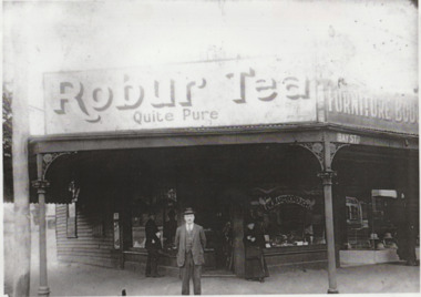
Photograph - Marlborough, secondhand shop, 221 Bay Street, Port Melbourne, 'Marlborough', c. 1918
Brought by Fred Nicholson from donor Veronica Aldridge Subsequently researched by Terry Keenan -- see People file for minformationLaminated A4 photo of 'Marlborough' secondhand shop 221 Bay Street, corner of Liardet Street.business and traders - secondhand dealers, marlborough, arnold walter -
 Port Melbourne Historical & Preservation Society
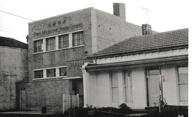
Photograph - YMCA Nott Street June 1973, Reverend Donald LANGFORD, June 1973
The YMCA Port Melbourne Youth Centre at 311 - 313 with the next door cottage being 321.B & W photograph of YMCA Nott Street between Bridge & Spring Streets June 1973.June 1973built environment - demolition, built environment - domestic, ymca, port melbourne youth centre -
 Clunes Museum
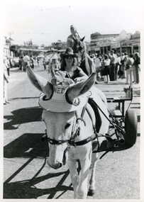
Photograph
BLACK AND WHITE PHOTOGRAPH DECORATED PONY, CART AND DRIVER, IN STREET PARADE, FRASER STREET, CLUNESlocal history, photography, photographs, events and celebrations -
 Stawell Historical Society Inc
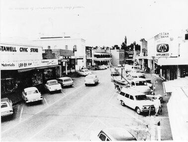
Photograph, Upper Main Street Removal of Verandahs, 1960's
Stawell Civic Store, Senghpa's, Commercial Hotel, Oriental Bank/Bank of Australasia, ES & A Bank Upper Main Street Taken from higher up with cars in Main Street looking eastThe removal of verandahs from shop frontsstreetscape -
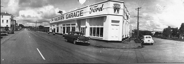 Stawell Historical Society Inc
Photograph, Nalder's garage 1955
Corner of Patrick Street and Sloane Street Stawell. Two cars outside and petrol bowsers visible.1955streetscape, transport -
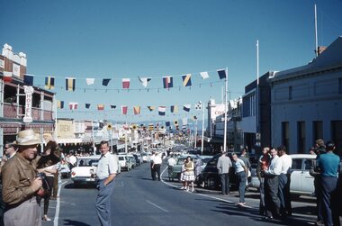 Stawell Historical Society Inc
Photograph, Ian McCann, Parades
Main Street Stawell with Flags across the Street showing the Bull & Mouth Hotel. Easter 1962parades, easter -
Whitehorse Historical Society Inc.
Article, Readers all over the place, 2001
Article on street sign construction by Art Craft, Nunawading, including photo of sign for Somers Street.Article on street sign construction by Art Craft, Nunawading, including photo of sign for Somers Street.Article on street sign construction by Art Craft, Nunawading, including photo of sign for Somers Street.street signs, art craft, nunawading, patterson, matt, naccari, adrian, holden, lela -
 Whitehorse Historical Society Inc.
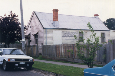
Photograph, House - Edward Street Mitcham
Coloured photograph of house in Edward Street Mitcham, since demolished for the Britannia Street Car Park.edward street, mitcham -
 Whitehorse Historical Society Inc.
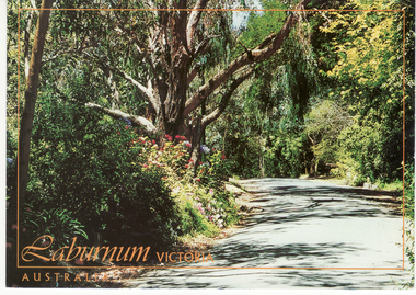
Postcard, Postcard - Laburnum
Available for purchase from Mitcham Newsagency, Whitehorse Road, MitchamColoured postcard showing Linum Street, Laburnum - one of three National Trust streets in the arealinum st., laburnum -
 Whitehorse Historical Society Inc.
Photograph, Home of Edgar Fredrick Walker, 1/09/1976 12:00:00 AM
Black and white photo of Edgar Fredrick Walker's home on the corner of Benares Street & Meerut Streetbenares street, mitcham, australian tesselated tile co. pty. ltd. -
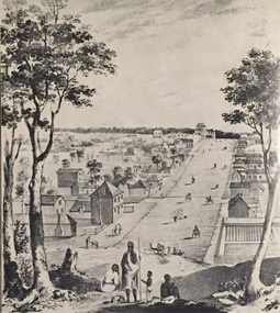 Ballarat Heritage Services
Image, Collins Street, Melbourne in 1840, 1934
A drawing of Collins Street, a main street in Melbourne Victoria. Aborigines stand in the foreground overlooking the scene. collins street melbourne, melbourne, aborigines -
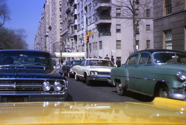 Robin Boyd Foundation
Slide, Robin Boyd, 1967
Colour slide in a mount. Street scene New York, East 73rd Street, New YorkMade in Australia / 2 / JUN 67M6slide, robin boyd -
 Bendigo Historical Society Inc.
Slide - 130 Garsed Street Bendigo
130 Garsed Street Bendigo - Late Edwardian c1925 - not found on Google Street view searchhistory, bendigo, national trust collection bendigo, 130 garsed street bendigo -
 Bendigo Historical Society Inc.
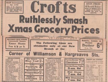
Document - BENDIGO BUSINESSES COLLECTION: CROFTS STORES
Advertising pages for Crofts Stores Bendigo cr. Williamson and Hargreaves Streets and 224 Mitchell Street.bendigo, business, crofts stores -
 8th/13th Victorian Mounted Rifles Regimental Collection
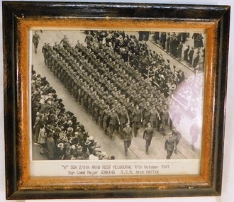
Photograph, October 1941
The 2/8th Armoured Regiment was raised in June 1941 under the command of Lieutenant Colonel W G Hopkins with officers and men selected from the wider AIF in Victoria. The regiment trained in newly arrived M3 General Grant tanks at Puckapunyal before moving north to Singleton, then the Wee Waa plains. The regiment sailed for New Guinea in April 1943 and carried out mobile defence to airfields at Port Moresby, Milne Bay, Dobadura and Popondetta. The regiment returned to Australia in February 1944 and disbanded as an armoured regiment and retrained as Nos 41, 42 and 43 Landing Craft Companies. They returned to the South West Pacific serving at Bougainville, Balikpapan, Lae and Wewak.Good study showing men of an armoured regiment from Victoria marching in Melbourne early in WWII (1939-45)Framed photograph of soldiers marching through Melbourne city street; crowds on both sides of street.Below photograph ""A Squadron 2/8th Armoured Regiment , Melbourne, 17th October 1941. Squadron Commander Major Jenkins. RSM Arch Martin"2/8th armoured regiment, melbourne -
Stawell Historical Society Inc
Functional object - Bottle, 1920's
Heywood Cordial Bottle. Sandblasted Clear Glass. Corner of 20 Sloane Street and Skene Street.stawell -
Canterbury History Group
Document - Plan for the proposed laundry at Canterbury Bowling Club, 1986
Plans for the proposed laundry at Canterbury Bowling Club cnr Kendall Street and Chaucer Street Canterburycanterbury, canterbury bowling club, kendall street, chaucer street, lawn bowls, plans, laundries -
 Federation University Historical Collection
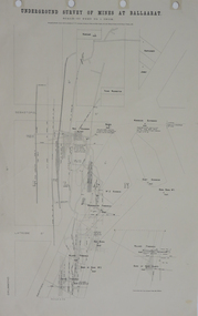
Plan, Underground Survey of Mines at Ballarat, 1886, 1886
Plan showing the streets of Ballarat (Sebastopol Street, LaTrobe Street, Drummond Street, Errard Street). Mines include Williams' Freehold, Band of Hope Quartz, Wilson's Freehold, Smith's Freehold, Washington Freehold, Kohinoor No. 2, East Korinoor, Burra Burra No 1, Wareham's, Hawthorne's, Jones', Young Washington, New Kohinoor, Benn's,plan, mining, cgt, williams' freehold, band of hope quartz, wilson's freehold, smith's freehold, washington freehold, kohinoor no. 2, east korinoor, burra burra no 1, wareham's, hawthorne's, jones', young washington, new kohinoor, benn's -
 Kew Historical Society Inc
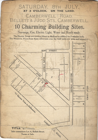
Plan - Subdivision Plan, 10 Charming Building Sites, 1930-1940
This subdivision plan shows 10 lots, numbered A-J, that were offered for sale in Camberwell. Streets in the subdivision include Camberwell Road, Judd Street, Bellett Street and King Street. The plan lists existing houses in the vicinity including weatherboard and ‘Rough Cast’ villas. The old Golf Links are identified at the rear of the Bellett Street lots.subdivision plans -- camberwell (vic.) -
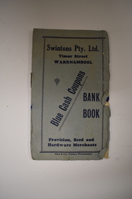 Warrnambool and District Historical Society Inc.
Leaflet, Kaye & Son, Printers, Swintons, Mid 20th century
This leaflet was a promotion tool of the Warrnambool business, Swintons Pty Ltd. It was used to insert stamps given by the firm when goods were purchased. When the pages were filled with 200 stamps the owner was given two shillings and sixpence in cash. It was a reward to the regular customer. William and Ann Swinton migrated to Australia in 1854 and for a decade William Swinton worked as a builder and carpenter in the Warrnambool area. In 1865 he opened a store in Timor Street, Warrnambool selling groceries, hardware, glassware and china. By 1888 the business was known as William Swinton and Sons. Branch stores were opened in Cudgee, Nullawarre, Wangoom, West Warrnambool and South Warrnambool. After William Swinton’s death, his son, Robert, became the first managing director of Swintons Pty Ltd. In 1934 the business split, with George Swinton and Sons selling furnishings, clothing and glassware and Swintons Pty Ltd selling groceries, seeds, produce and hardware. Today the Swinton family still operates a furniture and bedding store in Timor Street. This leaflet is of interest as an example of the advertising practices carried out by the firm of Swintons Pty Ltd, an important business in Warrnambool for many years. The current Swinton business in Timor Street, Warrnambool is the oldest family business in Warrnambool and, with the name Swinton associated with Timor Street businesses for 152years, it is amongst the oldest family businesses in Australia.This is a leaflet with a grey cover and four pages inside. The cover has dark blue printing and the pages have black printing and are ruled into 15 spaces. There are over 100 blue stamps stuck onto the ruled spaces. The cover is tattered at the edges and one stamp is loose.‘Swintons Pty Ltd Timor Street Warrnambool Provision, Seed and Hardware Merchants Blue Cash Coupons Bank Book’ swinton family businesses, warrnambool, history of warrnambool -
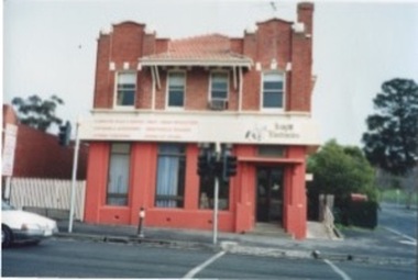 Kilmore Historical Society
Photograph, 27 Sydney Street, 06/06/1996
Was the building which housed the State Bank before it moved to 40 Sydney Street.15cm x 10cm colour photograph of the building 27 Sydney Street. Double story building with the bottom floor in a red render and the rest of the building in a red brick. The building is occupied by Knight Electronics (Leading Edge Computers). There is a sign stating the services of the store.Written on the back: 27 Sydney St., Kilmore. 6th June 1996 Photo: Heather Knightbanks and banking, shopfronts, retail stores, storefronts -
 Surrey Hills Historical Society Collection
Photograph, Grovedale Road Quarry in the 1920s - looking north, c1920
The quarry was part of John Butler Maling's property. He was one of the original settlers of the area and farmed the area between Weybridge Street and Whitehorse Road. Clay was quarried from part of this area and used to make the bricks used in the construction of his home, known as 'Ancyra'. This is still extant at the corner of Weybridge and James Streets. Maling grazed cows and used the quarry as a water source. He was the uncle of John Butler Maling, Mayor of Camberwell. He was married to Kate Conlon in 1882. They had 3 children: Silas Young, Alick and Zillah. Maling was born in c1829 in Shepreth, Cambridgeshire; he died in Surrey Hills on 9 October 1912 and is buried in Box Hill Cemetery - CE-*-0586. Mrs Kate Maling (born c1859 in Co Meath, Ireland) died at the property on 8 March 1921. She is buried in Brighton General Cemetery. Probate was valued at over 10,000 pounds and included other properties in Sandringham, Hawthorn and Macedon. At the time of her death the Surrey Hills property was described as being 23 cres with 2 brick houses, 1 cow, 2 heifers and 40 fowls or chickens. The property was subdivided after her death. The quarry was filled in after several drownings or near drownings and the land is now occupied by a park and playground maintained by the City of Boroondara. Beckett Park is sited on horizon to the left beyond the trees. This documents the landscape prior to close settlement and is material to early building and farming in the Surrey Hills area.Black and white photo of the quarry between Grovedale Road and James Street taken in the 1920s and looking north. In the foreground is an area of water with high banks dividing the horizontal centre. Beyond are paddocks and trees behind which is a row of at least 3 single-storey houses. Light poles can be seen along a distant street. There are many mature trees in the background. The houses and trees are positioned along Whitehorse Road in the vicinity of Westminster Street. Shadows indicate the photo was taken in early morning or evening.quarries, grovedale road, james street, surrey hills, balwyn, clay quarries, ancyra, kate conlon, kate maling, john butler maling, farming -
 Bendigo Historical Society Inc.
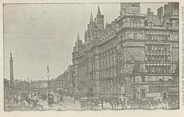
Postcard - Alice McGregor Postcard Collection, 1900 - 1920
Alice McGREGOR Born: 1908; unknown parents. Possibly adopted by the Salter family? Electoral Roll 1936: Highland Terrace Kangaroo Flat. Alice Mary Salter and William Robert Salter living together; presumed to be sister and brother. William Robert Salter was killed in a MVA in Bendigo in 1937 aged 26. In Victoria in 1938, Alice Mary Salter married James Thomas McGregor (born Victoria 1917, died Victoria 1983, buried Fawkner Cemetery) Lived: 1968; 22 Wade Street Golden Square Alice McGregor Died: 1999 aged 91 at Anne Caudle Centre, Bendigo Buried: Kangaroo Flat Cemetery See additional research. Postcard Album of Alice McGregor contained 86 post cards.Postcard Album of Alice McGregor containing 86 postcards. See 1400 B&W photo of the London & North Western Hotel, Lime Street Station, Liverpool. A multi-story building overlooking a statue atop a column. Horse drawn vehicles and pedestrians in the street. Addressee - Miss Kelly, Norwood, Wills St, Bendigo, Australia Sender - M.I. Grendell (?) Dated 25 5.06, Liverpool postcard, collector, alice mcgregor -
Port Melbourne Historical & Preservation Society
Photograph - 85 & 86 Evans Street, Port Melbourne, Meredith Turnbull, Dec 1996
Meredith Turnbull photographed this series in 1996 to record the rapidly changing streetscape, which had already had a number of old houses replaced by concrete two-storey structures under the State government's urban consolidation policyFrom a series of 70 colour photos recording all buildings in Evans Street from Graham Street overpass to Ingles Street, as photographed from the railway reservation, by Meredith Turnbull in December 1996 - number 85, 86 (corner shop at Bridge Street)House numbers noted on backbuilt environment - domestic, meredith turnbull -
Port Melbourne Historical & Preservation Society
Photograph - 141 Evans Street (Raglan Street Housing Commission flats), Port Melbourne, Meredith Turnbull, Dec 1996
Meredith Turnbull photographed this series in 1996 to record the rapidly changing streetscape, which had already had a number of old houses replaced by concrete two-storey structures under the State government's urban consolidation policyFrom a series of 70 colour photos recording all buildings in Evans Street from Graham Street overpass to Ingles Street, as photographed from the railway reservation, by Meredith Turnbull in December 1996 - number 141 - Raglan Street Housing Commission flatsHouse numbers noted on backbuilt environment - domestic, built environment - public housing, meredith turnbull -
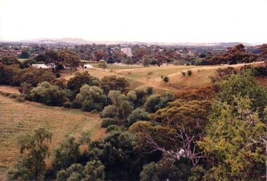 Hume City Civic Collection
Photograph, c 1980s
The photograph although recently taken shows the original settled area in Sunbury, which included Goonawarra Vineyard and Macedon Street which was once the business centre of Sunbury township before the railway was established.A coloured photograph of Sunbury Township looking west from above Jacksons Creek and Goonawarra Winery. Macedon Street can be seen in the middle distance and Mt. Holden and Burke Hill are across the skyline.sunbury township, mt. holden, burke hill, francis, james goodall, barnier, john, jacksons creek, goonawarra winery, george evans collection -
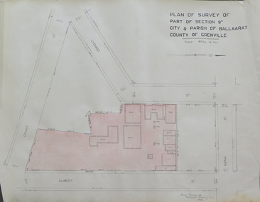 Federation University Historical Collection
Plan, Plan of Survey of Part of Section 9A City & Parish of Ballarat County of Grenville (Albert Street frontage), 1932
The M.B. John Trade Building was built on the Albert Street Frontage..1) Plan of SMB showing Albert, Grant, Lydiard and Dana streets, on paper with colored highlights undertaken by Ballarat School of Mines student George Murrowood in 1932 .2) Hand written page by George Murrowood, of technical description of land surveying Grade II 1932ballarat school of mines, surveying, george murrowood, albert street, alumni, m.b. john building, architectural plan -
 Glenelg Shire Council Cultural Collection
Photograph - Photograph - ANZ Bank, Portland, n.d
State Library of South Australia.Black and white photographic reproduction of earlier photograph. Depicting 2-storey bluestone building on a corner with door in left side, framed by double columns. Lamp on street corner and three figures (children ?) leaning against iron rail fence set in bluestone base.Front: A.N.Z. (Formerly Union) Bank. Cnr Percy & Julia Streets (typed label, top centre). Back: B21766/98 (pencil, upper left). State Library of South Australia Photographic Section. Order No. A16493 (stamp, centre).anz bank, commerce, banking, portland, bluestone building