Showing 6351 items matching " 31"
-
 Eltham District Historical Society Inc
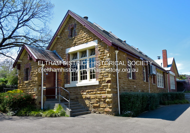
Photograph - Digital Photograph, Jim Connor, Eltham Primary School No. 209, Dalton Street, Eltham, 31 October 2015
This building is the earliest building remaining on site today. It was built in 1875 and was the second school building replacing the original 1856 building of stone walls with wooden shingles on the roof. That building needed to be replaced after the stone walls collapsed outwards. In August 1912 the school issued a requisition for remodelling of the school concerned with replacement of the existing windows with larger and wider windows to allow additional light into the school rooms and the erection of a wooden partition in the centre of the room. An extension to the building at rear and skylights in the roof were added in 1921. Only two low wooden stairs were originally provided to enter the porch. These were rebuilt by 1928. A steel mud grate was introduced 1930s/1940s and an infant shelter shed circa 1945.jim connor collection, dalton street, eltham primary school, eltham state school no. 209, state school no. 209 -
 Eltham District Historical Society Inc
Photograph, Fay Bridge, Former Glynn's Dairy Farm, Glynns Road, North Warrandyte, 31 August 2018
Glynn’s farm Originally Section 7, Parish of Nillumbik marked Aborigine Reserve in 1866 Crown Allotment 8, Section 7, Parish of Nillumbik, County of Evelyn, Certificate of Title Volume 4095, Folio 818.835, approx. 93 acres purchased by Joseph Panton in 1881 for £1/acre and known as Panton’s Point. By 1924 owned by S.S. Sergeant and called Riverswood. Sergeant commissioned Edna Walling to design the garden. In September 1929 the property was sold at auction by Mortgagee’s sale. Described as well built, brick, tile roof, Attic Villa containing downstairs 7 good rooms, bath, scullery, inside lavatory, etc. Upstairs 2 bedrooms and sleep out. Outbuildings compromising of brick and weatherboard wash house, stables, workshop, feed room, cow bails, large G.I. Hay shed, etc In January 1931 Riverswood property was proclaimed a sanctuary for native game for the entire year. A private swing bridge crossed the river at Pound Bend was known as Pearson’s bridge after C.W.K. Pearson who bought Riverswood in the early 1930s. The bridge was swept away in the December 1934 floods. Riverswood was sold by C.W.K. Pearson at auction on 25 November 1936. Described as a beautiful farm home of 93 acres and over one mile of River Yarra frontage, modern brick residence, lovely garden, rich river flat pastures, model poultry farm. The fine brick home was destroyed on Black Friday (13 Jan.) 1939. It was still a ruin when the Evelyn Evans purchased Waikowhane above Riverswood in 1940. The Glynn family purchased the Riverswood property in 1941 from Robert and Emily Hannon. Their son Kenneth Patrick Glynn inherited the property and he set about clearing the land during WW2 selling wood. Prior to marriage, Kenneth was living alone on the farm in a house he had built from whatever was available. He used the bluestone foundations from the original fine brick home. He met and married Honora Elizabeth Drew in early 1945 and their daughter Anna grew up on the farm. It was compulsorily acquired by the Board of Works in 1976 who then rented the house out in the 1980s. The property was transferred to Melbourne Parks and Waterways in 1996. Waikowhane was a pretty timber house built on top of the hill on 50 acres above Riverswood by retired nurse Jessie MacBeth. (This would be at the intersection of Glynns Road and Overbank Road where the big water tank is now situated on what was once James Orford’s property.) It was also destroyed Black Friday and she rebuilt it from the plans living in a caravan on site supervising the build. It was almost complete when she died May 1939. The property was bought by Evelyn Evans (a city girl) and her estranged husband in 1940. She had two sons, one only 9 months old at the time. It was a timber house with no power or water connected. The Ewen Cameron family bought Waikowhane in 1957. They had to evacuate when the 1961 bushfires swept through. The house was saved by Matcham Skipper. It was demolished by Melbourne Water in the 1990s when they acquired it.fay bridge collection, 2018-08-31, glynn's, glynn's dairy farm, glynns road, north warrandyte, parks victoria, ruins, riverswood, kenneth patrick glynn -
 Eltham District Historical Society Inc
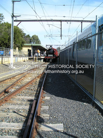
Photograph, Fay Bridge, Hurstbridge Wattle Festival, 31 August 2018
fay bridge collection, 2018-08-31, hurstbridge wattle festival -
 Eltham District Historical Society Inc
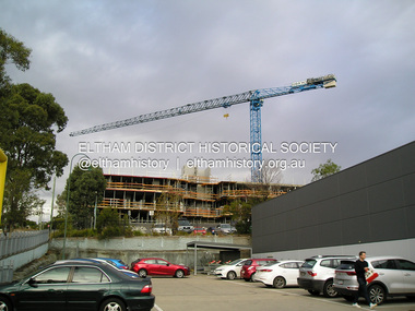
Photograph, Fay Bridge, The Canopy appartments under construction, Pryor Street, Eltham, 31 March 2019
First time a crane has ever been used for appartment construction in Eltham. The crane was illuminated at night and at times parked overhanging the roadfay bridge collection, eltham, eltham activity centre, pryor street, safeway supermarket, the canopy, woolworths, 2019-03-31 -
 Eltham District Historical Society Inc
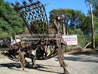
Photograph, Fay Bridge, Scrap iron sculpture outside St Andrews Stockfeed, 66 Caledonia St, St Andrews, 31 March 2019
fay bridge collection, 2019-04-07, art, caledonia street, click here to add keywords, sculpture, st andrews, st andrews road, st andrews stockfeed -
 Eltham District Historical Society Inc
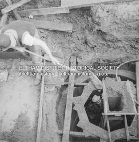
Album - Photograph, J.A. McDonald, Eltham-Greensborough Road, 31 July 1956
Diamond Creek Bridge (Bridge Street Bridge) Beam Pier No. 1 Showing formwork 31st July 1956Record of various Shire of Eltham infrastructure works undertaken during the period of 1952-1962 involving bridge and road reconstruction projects, sometimes with Eltham Shire Council Project Reference numbers quoted. It was during this period that a number of significant improvements were made to roads and new bridges constructed within the shire that remain in place as of present day (2022). In many situations, the photos provide a tangible visible record of infrastructure that existed throughout the early days of the Shire. The album was put together by or under the direction of the Shire Engineer, J.A. McDonald.infrastructure, road construction, shire of eltham, bridge construction, bridge street bridge, eltham, eltham-greensborough road, 1956-07-31 -
 Eltham District Historical Society Inc
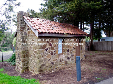
Photograph - Digital Photograph, Jim Connor, Caretaker's Cottage, Shire of Eltham Memorial Park, Garden Hill, Kangaroo Ground, 31 August 2015
jim connor collection, caretaker cottage, garden hill, kangaroo ground, shire of eltham memorial park -
 Eltham District Historical Society Inc
Photograph, Tess Justine (Nillumbik Shire Council), Construction work on replacement of Murray's Bridge over the Diamond Creek, Eltham North, 31 Mar 2022
Construction work on replacement of Murray's Bridge over the Diamond Creek on the Diamond Creek Trail Mary (Sweeney) Murray and John Wright Murray selected 80 acres, Lot C Section 16 and Lot 5 Section 17 Parish of Nillumbik, under an occupation license in 1866. John died in 1867 and freehold was granted to his son John in 1873. The farm was known as ‘Laurel Hill’. John Junior was an Eltham Shire councillor and sometime president from 1887 up until 1897. He added Lot A Section 16 to the farm in ca1888. John and his younger brother James arranged to rent/purchase Lot B Section 17, across Diamond Creek to the west, in ca1900. It appears that John and James farmed separately for a few years, with a new homestead built for James ad family on the high point of Lot B Section 17 in ca1910. John sold off Lot 5 Section 17 in 1912. When John died in 1912 James took over the land on both sides of the Diamond Creek. The old homestead on the west side of the Creek disappeared. A farm bridge over Diamond Creek from this period may have been located close to the northern boundary of the farm. John Langlands, owner of the farm known as ‘Ihurst’ on the west side of Diamond Creek to the south of the Murray’s land, died in 1907. In 1909 his land was then subdivided into 100 lots to become the ‘Glen Park Estate’. Other similar subdivisions of nineteenth century farms around Eltham in this period included the ‘Franktonia (or Beard’s) Estate’ to the northeast and ‘Bonsack’s Estate’ between Eltham and Greensborough. Soon after the opening of the railway extension line from Eltham to Hurstbridge in 1912, Glen Park and nearby residents including James Murray agitated for a railway station or siding to be located half-way between Eltham and Hurstbridge, so that the Glen Park residents who used the railway daily did not have to walk into the Eltham or Hurstbridge stations. Some believed Coleman’s Corner (opposite Edendale Farm) was an appropriate spot for the platform. James Murray was among those who thought the railway should be located on his land, closer to half-way between Eltham and Hurstbridge stations. The Railways Commissioners warned that the locals would have to fund these works themselves. The Glen Park Estate residents initially had difficulty accessing Eltham by road, with only an old low-level bridge over Diamond Creek at the south end of their estate. A new timber trestle bridge across the creek, now on Wattletree Road, was opened in 1915. Road access to the north was gained in 1927 when the new Murray’s Road, which crossed the Murray’s land, was built. Residents continued to agitate for a Glen Park station. By 1926 the Railways Commissioners’ preferred site was on the Murray’s land. They arranged an estimate of cost of a full-length platform. The estimate was too much for the locals, who in 1928 argued unsuccessfully for a shorter and hence cheaper platform. By 1929 Murray had agreed to donate the land, but the locals would still have to fund the works. Murray decided, unilaterally it would appear, to commence work on a timber trestle road bridge over Diamond Creek to link the new Murray Road to the proposed station. Late in 1929 he stopped work on the bridge, for reasons unknown, but started work again and completed the bridge in 1931. There is no further newspaper evidence of the campaign for the Glen Park station until 1939, when Murray and another local, Mr Maxwell, met the Railways Commissioner. The Glen Park locale now included 45 homes on the west side of the creek and 20 on the Eltham side. Most of the residents used the train every day. The Commissioner remained adamant that only a full-length platform could be built for safety reasons. It appears the campaign dissolved at this point. The increasing move to cars may have had an impact. There is no evidence of Murray’s bridge ever being connected to Murray’s Road, or of it having wide use for any purpose by locals. James Murray died in 1947 and the farm was taken over by his son James (Jim). Jim started to sell off parts of the farm in the 1980s, retaining a few acres around the ca1910 homestead and building a new house there. Recreation reserves were established along the creek. In ca1990 Murray’s bridge was renovated with steel girders as part of a bike/pedestrian path in the reserve. The old farmhouse was demolished in ca2014. Born digital image (5)diamond creek (creek), diamond creek trail, murrays bridge, ‘laurel hill’, john wright murray, mary (sweeney) murra, john murray jnr, james murray, john langlands, ‘ihurst’, ‘glen park estate’, beard's estate, franktonia, bonsack's estate, glen park estate, glen park railway station -
 Marysville & District Historical Society
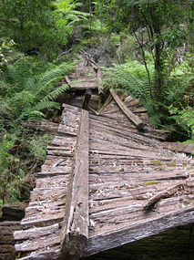
Photograph (item) - Colour photograph, 31-12-2008
A digital copy of a colour photograph of the timber tramway bridge along the Michaeldene Walking Track near Marysville in Victoria.A digital copy of a colour photograph of the timber tramway bridge along the Michaeldene Walking Track near Marysville in Victoria. The Michaeldene Trail to Taggerty River Lookout is a 4.3 kilometer lightly trafficked loop trail located near Marysville, Victoria. The track is one of several walking tracks located in and around Marysville in Victoria.timber tramway, michaeldene walking track, marysville, victoria, walking track -
 Marysville & District Historical Society
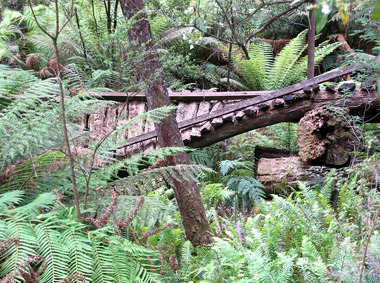
Photograph (item) - Colour photograph, 31-12-2008
A digital copy of a colour photograph of the timber tramway bridge along the Michaeldene Walking Track near Marysville in Victoria.A digital copy of a colour photograph of the timber tramway bridge along the Michaeldene Walking Track near Marysville in Victoria. The Michaeldene Trail to Taggerty River Lookout is a 4.3 kilometer lightly trafficked loop trail located near Marysville, Victoria. The track is one of several walking tracks located in and around Marysville in Victoria.timber tramway, michaeldene walking track, marysville, victoria, walking track -
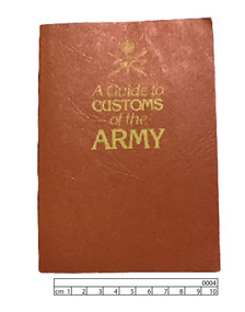 Lara RSL Sub Branch
Booklet, A Guide to Customs of the Army, 31/8/1983 (exact)
Customs and traditions are important factors in the growth of maintenance of our esprit de corps.Red imitation leather booklet with gold lettering for title. Above title is gold Army symbol. Bound with centre stapling. Pages 90gsm. Contains amendments 1 and 2A Guide to Customs of the Army....Title.On reverse cover...7610/66/118/7012........RM83/30184......Cat.No.84 3209 1....ISBN 0 644 00589 0....HAND WRITTEN 0004.dominion press, military, booklet, royal australian army, australian government publishing services, customs, army, customs of the army -
 Federation University Historical Collection
Photograph, Official Opening of Stage 1 Buildings on Mount Helen Campus, 1970, 31/10/1970
Official Opening of Stage 1 Buildings on Mount Helen Campus by The Hon. Nigel Bowennigel bowen, mount helen campus, opening, stage one buildings, morgan b. john, m.b. john, e.j. barker, jack barker, dudley erwin, rolly parfenovics, w.g. durant, bill durant, harold arblaster -
Federation University Historical Collection
Photograph, Turning of the Sod on Mount Helen Campus, 31/10/1970
Turning of the Sod on Stage 1 Buildings on Mount Helen Campus by The Hon. Nigel Bowenmount helen campus, stage one buildings, morgan b. john, m.b. john, e.j. barker, jack barker, nigel bowen, kaye barry -
Federation University Historical Collection
Book, Ballarat School of Mines Staff Attendance Register, 31/03/1941-08/03/1941
Ballarat School of Mines Staff Attendance Register. It has also been used as a scrapbook containing Machine Shop examiniation papersover hte period from First Term 1924 to the annual examination in 1951.ballarat school of mines, staff attendance, time book -
 Bendigo Military Museum
Certificate - OFFICER SCROLL, 31..3.1943
Capt Warick Rosenthal No TX6321 AAMC. Refer Cat No ‘s 622.3, 775.Embossed scroll on parchment paper in black lettering re the appointment of Warick Rosenthal to be an Officer of the Active Citizen Military Forces of the commonwealth from the 13th Day of October 1942.documents, certificates, military history -
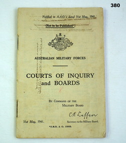 Bendigo Military Museum
Booklet - COURTS BOOKLET, Victorian Railways Printing Works, Courts of Enquiry and Boards, 31/05/1941
Belonged to Thomas Henry ISER V24933 and VX102660 2nd AIF. Refer Cat No 383.2 for his service history.Book, Australian Military Forces, Courts of Inquiry and Boards.Paper cover, beige with black printing."31st May 1941, A.M.R & O. 1588B"courts boards, enquiry military, booklets -
Frankston RSL Sub Branch
Pocketbook, Souvenir, Taschenbuch Groß-Deutschland, Geschichtstafel, Deutschlands Wehrmacht, Weltatlas, 31 August, 1941
provenance unknownSmall, soft cover, pocketbook presumably souvenired from a German soldier during the latter stages of World War 2. The pocketbook is of the type originally issued by the German military and was printed in August 1941, edited by Georg Westermann, Braunschweig. The book has a red coloured cover with black printing and contains 48 pages. Pages are printed in black, the maps are printed in colour. The pocketbook is in good condition, some pages have tears and the cover is scuffed. The pocket book title translates as "Paperback Greater Germany, History Chart, Germany's Wehrmacht, World Atlas" and is a collection of information about the German Reich, German military units and insignia and world maps, 1942 calendar, etc. The original owner has made markings on some maps and has made notes.The front cover is printed in black ink with the following "Taschenbuch Groß-Deutschland, Geschichtstafel, Deutschlands Wehrmacht, Weltatlas" -
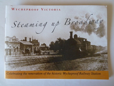 Wycheproof & District Historical Society Inc.
Railway Booklet, Steaming Up Broadway, 31/10/2010
Celebrating 125 years of Railway in WycheproofThe 28-09-1883 was a memorable date for Wycheproof for on that day the long-awaited official opening of the railway took place. It has been serving the district since then. In this booklet individual rail workers are acknowledged in a listing.Booklet of 14 pages - size A5. Sepia front cover photo depicts steam train hauling rail trucks up Broadway, Wycheproof, with early buildings and horse- drawn carriages showing. Back cover: Wycheproof Railway Station in its early beginnings - undated. Booklet celebrates the renovation of the historic Wycheproof Railway Station and 125 Years of Rail in Wycheproof. Chapters include: The Early Days, The Arrival of Rail, The New Century, Bulk Wheat and Million Bushell Silos, Railway Families and Workers, The Last Chapter , A new Era Begins. rail-wycheproof, bulk-wheat, railway-workers, station-renovation, steam-train -
4th/19th Prince of Wales's Light Horse Regiment Unit History Room
Training Pamphlet, Horticultural Press Pty Ltd, Small Arms Training Vol 1: Weapon Training 1944, 31/8/1944
Issued by HQ Australian Military ForcesSoft covered 94 page book15 -
 Mission to Seafarers Victoria
Drawing - Caricature, Series, Fred Negro, 31 March 2011
Fred Negro, cartoonist from St Kilda, made drawings of guests during Stephen Cummings concert in the Mission's courtyard on 25 June 2011. Stephen Cummings gave several concerts at the Mission in 2011 and 2012.A4 drawings in black ink on white paperfred negro, stephen cummings, andrea fleming, 2011, caricature, concerts, cultural events -
Mission to Seafarers Victoria
Article - Newspaper clipping, The Age, For Mission to Seamen, 31 May 1941
In 1941, a play in South Yarra was a fundraising opportunity for the Mission during wartime. Daryl Lindsay designed the programme of the evening. He was the Curator of the National Gallery of Victoria at the time. The article describes the design: "Mr. Daryl Lindsay made a special drawing for the front of the programmes, picturing a member of a merchant vessel on the bridge of his ship in a gale." He had previously illustrated the Mission's 1925 calendar.Shows the association with Melbourne's artworld.daryl lindsay, artists, fundraising, padre lavender, lady macpherson, reverend c. g. lavender, ngv -
 Greensborough Historical Society
Document - Advertising leaflet, Bundoora ALP SECC, 2006 State Election Campaign Bundoora: Campaign launch invitation, 31/10/2006
Invitation to Campaign Launch of Colin Brooks for State Legislative Assembly seat of Bundoora, 2 November 2006.1 p. colour leaflet, printed two sidesbrooks family, victoria parliament, elections, colin brooks, bundoora -
Mission to Seafarers Victoria
Letter - Correspondence, 31/10/1948
Quinn CollectionBlue self-folding letter (0394) type-written by Allan and addressed to Mrs S Quinn. Letter dated 31.0.48, post-marked Philadelphia 1948 and pre-franked with red ink.letters-from-abroad, m.s. fenris, allan quinn -
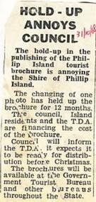 Phillip Island and District Historical Society Inc.
Newspaper Clipping, 31/10/1968
Newspaper clipping 1968Article on holdup of publishing of Phillip Island Tourist brochure.phillip island, phillip island tourist brochure -
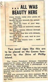 Phillip Island and District Historical Society Inc.
Newspaper Clipping, 31/10/1968
Newspaper clipping 1968Article about an environmental poem to be placed on a sign on the Cowes foreshore.phillip island, cowes foreshore, environmental poem -
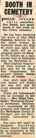 Phillip Island and District Historical Society Inc.
Newspaper Clipping, 31/10/1968
Newspaper clipping 1968Article on restoration of grave of Miss Eliza Coghlan at Phillip Island. She was 113 when she died and at that time was regarded as the oldest woman in Australia.phillip island, miss eliza coghlan, grave restoration -
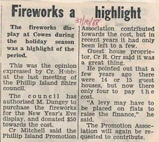 Phillip Island and District Historical Society Inc.
Newspaper Clipping, 31/10/1968
Newspaper clipping 1968Article on financing of fireworks displayphillip island, fireworks financing -
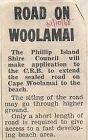 Phillip Island and District Historical Society Inc.
Newspaper Clipping, 31/10/1968
Newspaper clipping 1968article on application to extend Woolamai Roadphillip island, cape woolamai, woolamai road -
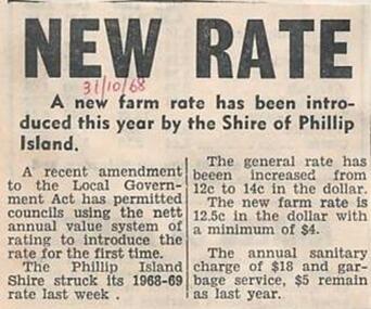 Phillip Island and District Historical Society Inc.
Newspaper Clipping, 31/10/1968
Newspaper clipping 1968Article on rates on Phillip Islandphillip island, council rates -
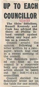 Phillip Island and District Historical Society Inc.
Newspaper Clipping, 31/10/1968
Newspaper clipping 1968Article on advice from shire solicitors about legal action by Council of Phillip Islandphillip island, phillip island shire council