Showing 6697 items
matching river
-
 National Vietnam Veterans Museum (NVVM)
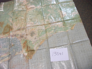
Map, Intelligence Map
Vinyl coated topographical map of part of Vietnam featuring main roads, towns and city locations current or ruined. River locations etc. Names all in Vietnamese language.map, vietnam -
 Tatura Irrigation & Wartime Camps Museum
Book, Finland, 1997
The book covers Finnish culture from religion, rock and roll, mythology to media, education, food, history, fashion. Inlcudes loose card with lake scene.Cream wrap around cover. River scene in frame on front by M Viljanen. Cover design - M Itkonen. Back cover - Golilla Taina Varri. 350 pages.finland culture, walczuk e, tatura, european history -
 Anglesea and District Historical Society
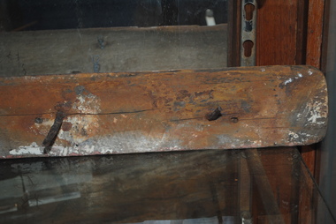
Ship Railing, 1895
"Inverlochy" wrecked 1902.Part of the railing from the "Inverlochy" which wrecked in 1902 on the "Ingoldsby" reef, Anglesea River, 1902. Includes three nails protruding at right angles from the wooden piece.inverlochy, ship railing -
 City of Ballarat
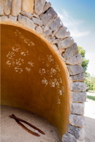
Artwork, other - Public Artwork, Deanne Gilson, Murrup Laarr by Deanne Gilson, 2019
Murrup Laarr translates as 'Ancestral Stones' in Wadawurrung. This artwork by Dr Deanne Gilson is located in the North Gardens Indigenous Sculpture Park. The park is a significant project for the City of Ballarat and features works by Aboriginal and Torres Strait Islander artists, celebrating the richness and diversity of culture and telling important cultural stories. Dr Deanne Gilson is a Wadawarrung Traditional Custodian and established artist. She installed the first artwork commissioned by the City of Ballarat for the Sculpture Park in early 2019. Murrup Laarr is a contemporary artwork consisting of a traditionally-built stone hut in the middle of a circle of basalt standing stones, marked with ceramic plates reflecting the stories and symbols of dreaming, memory, ceremony.The artwork is of aesthetic and cultural, social and spiritual significance to the people of Ballarat and to Wadawurrung peopleA traditional hut made from river stone and stacked rocks, with the hut surrounded by large basalt rocks with plaques featuring unique designs on stoneware plates imbedded into them. Murrup Laarr (Ancestral Stones), 2019 / By Deanne Gilson / Wadawurrung people have always used stones to mark places of ceremony and important business. The stones are the holders of memory and knowledge, Country and Spirit. They mark the cosmos and seasons. They follow the sun, marking the summer and winter solstice, important dates for planting and harvesting and telling stories of past, present and future. / The stones are alive and still present. Murrup Laar has been created using local basalt stones to tell Wadawurrung stories of dreaming, memory and ceremony. / “Creating Murrup Laarr (Ancestral Stones) at this time has placed Aboriginal people and practices back on Country and created a place to tell our stories. I am very honoured to have had this opportunity. An Aboriginal stone circle existed in Ballarat pre-colonisation; by putting back what was lost throughout colonisation I pay homage to my ancestors, past, present and emerging”/ – Deanne Gilson, March 2019 murrup laarr, wadawurrung -
 Wodonga & District Historical Society Inc
Album - Hume Reservoir Australia Album - Core wall with drainage tunnel and earth embankment in progress in Victoria, June 1924
This set of photos is from a leather bound album bearing the inscription "HUME RESERVOIR AUSTRALIA" plus 'The Rt. Hon. L. C. M. S. Amery, P. C., M .P.' all inscribed in gold. It was presented to The Rt. Hon. L. C. M. S. Amery, P. C., M. P, Secretary of State for Dominion Affairs on the occasion of his visit to the Hume Reservoir on 2nd November 1927. This album is of local and national significance as it documents the planning and development of the Hume Reservoir up to 1927. It was the largest water reservoir in the British Empire. The album records the pioneering engineering work that went into its construction.DEPARTMENT OF PUBLIC WORKS, N.S.W. RIVER MURRAY WATERS SCHEME. HUME RESERVOIR. 14. Core wall with drainage tunnel and earth embankment in progress in Victoria, June 1924.hume reservoir australia, river murray waters scheme, hume reservoir construction -
 Lakes Entrance Historical Society
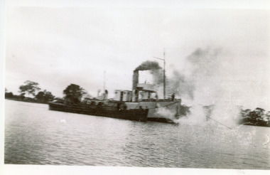
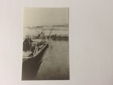
Photograph - W H Edgar, 1917
Typed note in album describes the photoBlack and white photograph showing PWD dredge WH Edgar with hopper barge during dredging operation at mouth of Mitchell River. Silt jetty at back. Bairnsdale Victoriaboats and boating, dredges -
 Lakes Entrance Historical Society
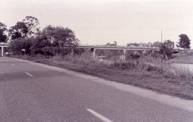
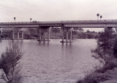
Photograph - Bridges, Fish Marie, 1995
Black and white photograph showing view of the Swan Reach bridge over the Tambo River. Traffic lights on bridge to control traffic and reduce weight. Swan Reach Victoriabridges, waterways, roads and streets -
 Lakes Entrance Historical Society
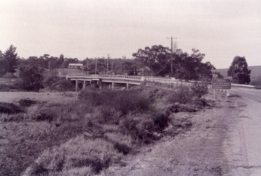
Photograph - Bridges, Fish Marie, 1995
Black and white photograph showing view of the Swan Reach bridge over the Tambo River. Traffic lights on bridge to control traffic and reduce weight. Swan Reach Victoriabridges, waterways, roads and streets -
 Lakes Entrance Historical Society
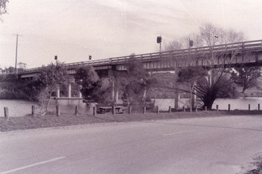
Photograph - Bridges, Fish Marie, 1995
Black and white photograph showing view of the Swan Reach bridge over the Tambo River. Traffic lights on bridge to control traffic and reduce weight. Swan Reach Victoriabridges, waterways -
 Lakes Entrance Historical Society
Photograph - Bridges, Fish Marie, 1995
Black and white photograph showing view of the Swan Reach bridge over the Tambo River. Traffic lights on bridge to control traffic and reduce weight. Swan Reach Victoriabridges, waterways -
Port Melbourne Historical & Preservation Society
Audio - PMHPS Meeting, Maribyrnong River and the ferry Blackbird, Peter SOMERVILLE, 27 Feb 2006
Recording of PMHPS Meeting on 27.02.2006. Recording done at Port Melbourne Bowling Club. Speaker was Peter SOMERVILLE on the Maribyrnong River and the ferry "Blackbird". Recording duration 51:23blackbird, transport - ferries, social activities, peter somerville -
Lakes Entrance Historical Society
Photograph - Reeves River, 1920 c
Also another black and white photograph of same view with a man in foreground 05298.1Black and white photograph showing view of Reeves River looking west towards Metung with islands Rigby and Flanagan on left and Nungurner on right Jemmys Point Lakes Entrancewaterways -
 Lakes Entrance Historical Society
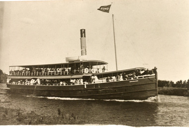
Photograph - SS Gippsland, c1930
A second copy existsSepia photograph showing the SS Gippsland in Mitchell River. Possibly within silt jetties. Both decks crowded with tourists. Hull painted dark colour. Bairnsdale Victoria ships and shipping, waterways -
 Kew Historical Society Inc
Photograph - Zig-Zag Bridge, 1924
Henry Beater Christian (1886-1962) , was a descendant of one of the earliest settler families in Kew. Employed at the Kew Asylum as a 'public servant', he was a skilled amateur photographer, photographing numerous scenes in Kew and on his travels around Victoria. The majority of his photographs date from 1916 to 1929. His finest photographs are housed in two photograph albums. Digital copy of a photograph from page 8 of the 47-page photograph album containing 261 gelatinous silver images, loaned by Diane Washfold with permission given to digitise and hold a copy in our collection. The Zig-Zag Bridge linked the grounds of the Yarra Bend and Kew Asylums. The wooden bridge was constructed in the 1870s and lasted through numerous floods until its destruction in 1929. A horizontal structure, the walkway was reached via a wooden staircase on the Kew bank of the river. The steps were required due to the different levels of the banks on this stretch of the river. The photo is taken from the Kew side of the river and shows clearly the width of the walkway on top of the bridge. "Zig-Zag Bridge"henry beater christian (1886-1962), landscape photography, kew (vic.) — yarra river, christian-washfold collection, photograph albums, zig-zag bridge -
 Wodonga & District Historical Society Inc
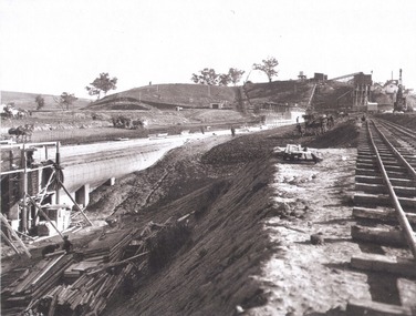
Album - Hume Reservoir Australia Album - Driving first row of piles for coffer dam across the river, December 1925
This set of photos is from a leather bound album bearing the inscription "HUME RESERVOIR AUSTRALIA" plus 'The Rt. Hon. L. C. M. S. Amery, P. C., M .P.' all inscribed in gold. It was presented to The Rt. Hon. L. C. M. S. Amery, P. C., M. P, Secretary of State for Dominion Affairs on the occasion of his visit to the Hume Reservoir on 2nd November 1927. This album is of local and national significance as it documents the planning and development of the Hume Reservoir up to 1927. It was the largest water reservoir in the British Empire. The album records the pioneering engineering work that went into its construction.DEPARTMENT OF PUBLIC WORKS, N.S.W. RIVER MURRAY WATERS SCHEME. HUME RESERVOIR. 19. Driving first row of piles for coffer dam across the river. New South Wales. December 1925. Cofferdams are temporary structures used where construction is being carried out in areas submerged in water. They are most commonly used to facilitate the construction or repair of dams, piers and bridges. To divert the river, a Coffer Dam was built across the old bed above and below the Dam site and tying into the end of the concrete wall built inside the levee bank. This completely surrounded the remainder of the site of the Dam and south wing wall, including an area of 12½ acres. hume reservoir australia, river murray waters scheme, hume reservoir construction -
 Wodonga & District Historical Society Inc
Map - Boorgunyah - "The Town that never was"
At the height of the river trade, there was a town surveyed and laid out, and streets were named. This town was to house the workers at the river port of Red Bank when the paddle steamers plied the Murray River as far as Albury, carrying produce such as wool and wheat to the various towns along the river in the 1800s. As the river trade died away, this town never went ahead – one might say, “The town that never was.” A lone gum tree stands on the site today.This item is significant because it documents plans which were made for the early development of Wodonga.A black an white map depicting the proposed location of the township. The map is based on a sketch and is not to scale,early wodonga, boorgunyah - "the town that never was", wodonga heritage -
 Kiewa Valley Historical Society
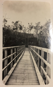
Photographs- 1 old black and white photograph of a wooden bridge over a river possibly Ryders Bridge in Tawonga. 2 –Enlargement of the original photograph showing the gentleman leaning on the bridge. Taken off the original photo
The bridge is not definitively identified, but is of similar construction style to other bridges built in rural areas around this time. Circa 1930”s and may be Ryders Bridge (Old Tawonga Bridge) which crosses the Kiewa River on Mountain Creek Rd Tawonga The first Tawonga bridge was built in 1884- destroyed by floods in 1916. New bridge constructed 1923 and destroyed in 1953. Present concrete bridge constructed in 1986 and named Ryders Bridge These wooden bridges were the only method for transporting stock and produce to market, transporting timber to the mills, sending and receiving mail and for local people to cross the many rivers in the area to go about their daily business. 1- Black and white photograph is glued onto heavy cardboard, which is yellowing with age. Top right hand corner has a tear in the cardboard. Photograph depicts a wooden bridge on wooden piles with 2 white wooden railings along the length of both sides. 2- Original photo has been digitally enlarged to show a gentleman in a light coloured suite and wearing riding boots leaning on the rails of the bridge. The bridge is not definitively identified, but is of similar construction style to other bridges built in rural areas around this time. Circa 1930”s may be Ryders Bridge (Old Tawonga Bridge) which crosses the Kiewa River on Mountain Creek Rd Tawonga bridge; tawonga bridge; kiewa valley -
Lorne Historical Society
Pamphlet - Tourist pamphlet Lorne, Lorne Victoria Australia
Victorian Railways printed a series of brochures publicizing holiday destinations.A folded paper souvenir pamphlet. The cover is a colored picture of Lorne from Scotsman’s Hill with two bathing suited young women in the foreground, and a blurb extolling the virtues of Lorne. On the back is a red, yellow and blue map of Lorne and district. Inside are eight black and white photographs of Lorne attractions,; the Main Street, tennis courts, Erskine River, walking tracks and the George River with the phrase ,” The resort that embraces everything for the perfect holiday.”souvenirs, pamphlets, victorian railways, -
 Bendigo Historical Society Inc.
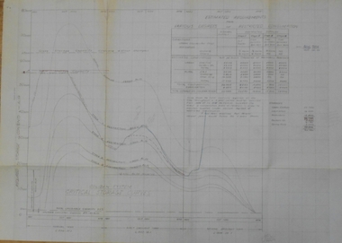
Document - STATE RIVERS AND WATER SUPPLY COMMISSION : COLIBAN SYSTEM CRITICAL STORAGE CURVES
State Rivers and Water Supply Commission of Victoria. Coliban System. Construction of Lake Eppalock. Chart titled 'Coliban System Critical Storage Curves'. Includes table headed ' Estimated requirements for various degrees of restricted consumption' related to the demand on the Coliban River. Figures on storages of Upper Coliban, Lauriston, Malmsbury, Barkers Creek, and Spring Gully. There are penciled notations added. The information appears to be for the years 1957/58/59. state infrastructure, water supply, coliban system, state rivers and water supply commission of victoria. coliban system. lake eppalock. -
 Greensborough Historical Society
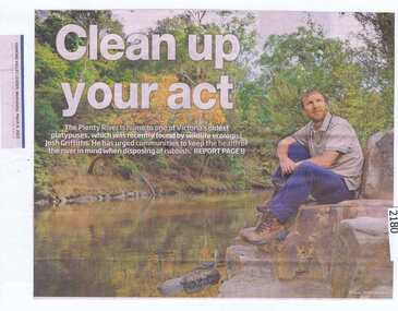
Newspaper clipping, Clean up your act, 04/03/2015
Ecologist Josh Griffiths recently found a platypus in the Plenty River and urges the community to keep the river clean.News clipping, black text, colour image.plenty river, platypus, josh griffiths -
 Orbost & District Historical Society
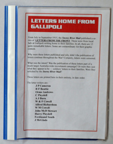
folders, Letters Home From Gallipoli, March / April 2015
These were compiled for the WW1 exhibition held in Orbost in April 2015.During World War 1 letters were a welcome means of personal communication for many people. Most information came from newspapers or broadcasts. Two blue plastic folders containing copies of letters from Gallipoli. They are printed copies of letters which had ben publuished in the Snowy River Mail from 10.9.1915 - 10.10.1915.On folders -Folders Made in Chinagallipoli-correspondence ww1 soldiers-orbost -
 Port of Echuca
Black and white photograph, Approx. 1980
Black and white photograph of an unknown lock scene where 3 men are working from a hollow platform structure, with one person being a diver coming up or going down a ladder. Another person appears to have hold of a hose (could be oxygen) and the back view of the other person appears to be working with them watching what is happening. This could be part of lock construction as there appears to be cranes and a tripod in the distance.This black and white photograph demonstrates historical and social significance in that it gives a close up view of workmen in the process of lock construction. It appears that there is a diver suited up with helmet on, descending the ladder and a person holding what appears to be hose connected to the person diving. This scene is possibly from the beginning of the 20th century and could be about the development of the irrigation industry.Black and white photograph , portrait format, of 3 men on a hollow platform structure in a river. One man is a diver and is on a ladder which steps down into the water. Copy of an original photograph. On reverse in pencil: Price, Lock scene, location Unknown. lock scene, lock construction, price family collection, irrigation industry -
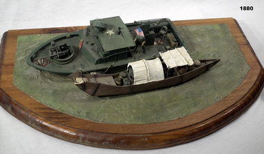 Bendigo Military Museum
Memorabilia - DIORAMA VIETNAM, Post 1975
Diorama of US river operation in Mekong Delta showing a US patrol boat with a local village boat alongside, model hills and figurines. On tan wooden base with green background. military history-army, handcrafts, diorama, riverine -
Glenelg Shire Council Cultural Collection
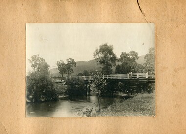
Painting, George H.L Pentland, Casterton 1889, 1889
Casterton & District Historical Society Inc.Painting, oil on canvas showing a 'bird's-eye' view' of the township of Casterton in the late 19th century. It shows the Glenelg River, the bridge, main street and rolling landscape of the Western District.casterton, oil painting, landscape -
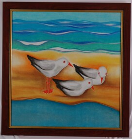 Glenelg Shire Council Cultural Collection
Painting, Home at Narrawong, c. 1999
Exhibition in the Arts Company in 1999?Painting of three seagulls standing on a sandbar between river and ocean. Painted in bright colours, predominantly blues, green and orange. Framed under glass in wooden and gold-coloured frame.Front: (no inscriptions) Back: (no inscriptions)narrawong, painting, seagulls -
Glenelg Shire Council Cultural Collection
Negative - Glass Plate Negative - Five women standing/sitting on a wooden jetty over river, bushland setting, 1890-1910
Glass plate negative. Image shows five women standing/sitting on a wooden jetty over river, bushland setting. Clothing estimated to be late 19th, early 20th Century. -
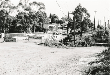
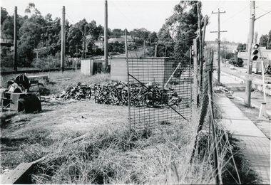 Eltham District Historical Society Inc
Photograph, Para Road Bridge construction, Briar Hill, near Greensborough, c.1971, 1971c
Three black and white photographs; two showing construction works of the bridge over the Plenty River at Briar Hill and one of Greensborough Park, Grimshaw Street, summer 1971-1972greensborough, briar hill, para road, bridges, construction, plenty river -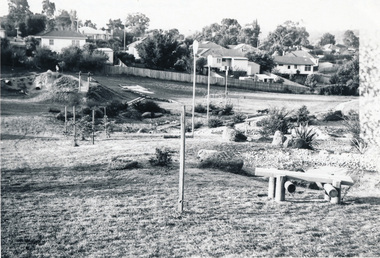
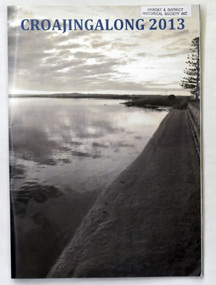 Orbost & District Historical Society
magazine, Croajingalong 2013, 2013
The name Croajingolong derives from the Australian Aboriginal Krauatungalung words galung, meaning "belonging to" and kraua, meaning "east". This is the sixty-sixth edition of the annual school magazine. Orbost High School / Orbost Secondary College has played a significant part in the education of senior students in the Orbost district . It is the sole senior educational institution. This magazine is representative of its history and is a useful reference tool.A glossy magazine titled " Croajingalong 2013". On the front cover is a photograph of the Snowy River at Marlo. On the back cover is the Orbost High School badge in various colours. It contains coloured photographs.magazine orbost-secondary-college education