Showing 3762 items
matching surveyed
-
 City of Moorabbin Historical Society (Operating the Box Cottage Museum)
Certificate - Receipt for Burial of Stillborn Child, James & Mary Jones Child, 1900
James Jones was the son of Philip Jones, a Chairmaker, and Ann Jones who settled in East Brighton after the sale of land c1852 in the area of the Henry Dendy Special Survey of 1841. Mary Ann Moore was the daughter of Thomas Moore, a Gardener, and Sarah Harris who also settled in Brighton c1852. James and Mary Ann Jones settled and raised their family in East Brighton now Bentleigh. Mr John Herron resided at 4 Vickery St Bentleigh until 1989. Sadly Martha Jones born 1888 died in 1890 and James Jones had to purchase a plot at Brighton General Cemetery for her burial. Baby Ethel May was interred in 1893 and then Mary Ann in 1903 and James in 1940. Their stillborn baby was buried in the Wesleyan public grave in 1900James Jones and Mary Ann Moore were born in Brighton c1857 and c 1859 into pioneer market gardener families in the area of the Dendy Special Survey of 1841. They married in 1883 and raised their family in East Brighton, now Bentleigh. Sadly infectious diseases took the lives of many infants throughout the Colony of Victoria due to the poor state of water supply and sewerage disposal and locally the swamps of the Elster Creek were a constant breeding ground. Martha Jones born 1888 died 1890 and was interred in Brighton General Cemetery in a family plot purchased by her father James Jones. In 1893 another daughter Ethel May died and was buried in the family plot. A stillborn baby was interred in the public grave of Brighton General Cemetery in May1900An original paper receipt No.4360 for payment on 22 May 1900 by James Jones to Brighton General Cemetery of 6 shillings for the burial of a stillborn baby Jones in the Wesleyan section of the public graves. There is no fee for ‘re-opening the grave’ purchased by James Jones in 1890 and in which his daughters Martha 1890 and Ethel May 1893 were interred. BRIGHTON GENERAL CEMETERY / No. 4360 (stamped) 22 May 1900 ( hand written) / Received of Mr Jas. Jones ( hand written) / the sum of 6 s being the following / charges in Wesleyan / Portion No. -- Compt. - Name of / Deceased ‘Stillborn child of Jas / & Mary Ann Jones’ (hand written) Along left side “Brighton Leader” Print, Bay Street, North Brighton This receipt is signed A Shimon man. Secretary wesleyan church, brighton general cemetery, vaccination, pioneers, early settlers, typhoid, brighton, moorabbin, bentleigh, market gardeners, jones james, jones mary ann, jones martha, dendy henry, dendys special survey 1841, infectious diseases, water supply, elster creek, melbourne, orford g h, printers, southern cross office, “brighton leader” print, bay street brighton, jones ethel may -
 City of Moorabbin Historical Society (Operating the Box Cottage Museum)
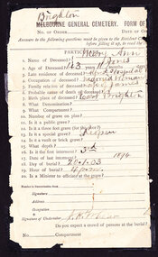
Certificate - Documents relating to Death and Burial of Mary Ann Jones, 1903
James Jones was the son of Philip Jones, a Chairmaker, and Ann Jones who settled in East Brighton after the sale of land c1852 in the area of the Henry Dendy Special Survey of 1841. Mary Ann Moore was the daughter of Thomas Moore, a Gardener, and Sarah Harris who also settled in Brighton c1852. James and Mary Ann Jones settled and raised their family in East Brighton now Bentleigh. Mr John Herron resided at 4 Vickery St Bentleigh until 1989. Sadly Martha Jones born 1888 died in 1890 and James Jones had to purchase a plot at Brighton General Cemetery for her burial. Baby Ethel May was interred in 1893 and then Mary Ann in 1903 and James in 1940. Their stillborn baby was buried in the Wesleyan public grave in 1900James Jones and Mary Ann Moore were born in Brighton c1857 and c 1859 into pioneer market gardener families in the area of the Dendy Special Survey of 1841. They married in 1883 and raised their family in East Brighton, now Bentleigh. Sadly infectious diseases took the lives of many infants throughout the Colony of Victoria due to the poor state of water supply and sewerage disposal and locally the swamps of the Elster Creek were a constant breeding ground. Martha Jones born 1888 died 1890 and was interred in Brighton General Cemetery in a family plot purchased by her father James Jones. In 1893 another daughter Ethel May died and was buried in the family plot. A stillborn baby was interred in the public grave of Brighton General Cemetery in May1900. Mary Ann Jones died at age 43years and was interred in January 19033 Original documents associated with the death of Mary Ann Jones 18th January 1903. 1) An original paper receipt No. 4797 for payment on 19th January 1903 by James Jones to Brighton General Cemetery of £1 . 1s for the burial of Mary Ann Jones in a plot 4 feet x 8 feet, in the Wesleyan section portion 199 compartment G. 2 ) An original part- section of Form of Notification of Death from The Alfred Hospital Prahran with personal particulars and burial details , signed by the Undertaker. 3) An original Mourning Card 1) BRIGHTON GENERAL CEMETERY / 4797 ( stamped) / 19th Jan. 1903 (hand written) / Received from “Mr James Jones”(hand written) / the sum of £1 . 1s being the following / charges in Wesleyan (hand written) / Portion No, 199 compt.G Name of / Deceased ‘Mary Ann Jones”(hand written) / For re-opening grave interment ‘third’ £1 . 1s./ signed by S. P. Simmonds Secretary. 2) ‘Brighton’ (written over Melbourne) GENERAL CEMETERY FORM OF… / No. of Order____ Date of… / PARTICULARS / Signature of Undertaker J H Lear On back of notice are guides to the questions 3) In Loving Remembrance of / Mary Ann Jones / Dearly Loved Wife of James Jones / Died January 18th 1903 / Aged 43 Years / Poem - “One Less at Home “ / DEEPLY REGRETTED / Art Engraving Company, Royal Arcade, Elizabeth Street, Melbourne * wesleyan church, brighton general cemetery, vaccination, pioneers, early settlers, typhoid, brighton, moorabbin, bentleigh, market gardeners, jones james, jones mary ann, jones martha, dendy henry, dendys special survey 1841, infectious diseases, water supply, elster creek, melbourne, orford g h, printers, southern cross office, “brighton leader” print, bay street brighton, jones ethel may, public grave brighton -
 City of Moorabbin Historical Society (Operating the Box Cottage Museum)
Certificate - Documents, Burial James Jones 1940, c1940
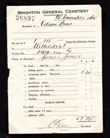
James Jones was the son of Philip Jones, a Chairmaker, and Ann Jones who settled in East Brighton after the sale of land c1852 in the area of the Henry Dendy Special Survey of 1841. Mary Ann Moore was the daughter of Thomas Moore, a Gardener, and Sarah Harris who also settled in Brighton c1852. James and Mary Ann Jones settled and raised their family in East Brighton now Bentleigh. Mr John Herron resided at 4 Vickery St Bentleigh until 1989. Sadly Martha Jones born 1888 died in 1890 and James Jones had to purchase a plot at Brighton General Cemetery for her burial. Baby Ethel May was interred in 1893 and then Mary Ann in 1903 and James in 1940. Their stillborn baby was buried in the Wesleyan public grave in 1900James Jones and Mary Ann Moore were born in Brighton c1857 and c 1859 into pioneer market gardener families in the area of the Dendy Special Survey of 1841. They married in 1883 and raised their family in East Brighton, now Bentleigh. Sadly infectious diseases took the lives of many infants throughout the Colony of Victoria due to the poor state of water supply and sewerage disposal and locally the swamps of the Elster Creek were a constant breeding ground. Martha Jones born 1888 died 1890 and was interred in the Brighton General Cemetery in a family plot, in the Wesleyan Section, purchased by her father James Jones. In 1893 another daughter Ethel May died and was buried in the family plot. A stillborn baby was interred in the public grave of Brighton General Cemetery in May1900. Mary Ann Jones died, at age 43years, and was interred in January 1903. Finally in November 1940 Mr James Jones was buried in the family grave. 2 original paper Receipts associated with the Burial of James Jones at Brighton General Cemetery 20th November 1940 by Nelson Bros. Funeral Directors of Williamstown1) 4202 Re the Funeral of the late Mr James Jones / 43 Douglas Parade Williamstown (Tel 34 & 43)/ 27/11/1940 / Received from Mr J P Jones./ by CHEQUE/ CASH the sum of Twenty eight pounds / ten shillings - pence/ WITH MANY THANKS / 7/563 / NELSON BROS./ £28:10:0 per N.Flack / THIS is our only recognised form of receipt / In full settlement / Stamped VICTORIA STAMP DUTY 3d 2) 36897 BRIGHTON GENERAL CEMETERY 20November 1940/ Received of Nelson Bros./ the sum of £1.15.- being the following charges/ in Methodist / Portion No. 199 Compt. G / Name of Deceased James Jones / for reopening grave £1.15.- / signed C Guy Secretarywesleyan church, brighton general cemetery, vaccination, pioneers, early settlers, typhoid, brighton, moorabbin, bentleigh, market gardeners, jones james, jones mary ann, jones martha, dendy henry, dendys special survey 1841, infectious diseases, water supply, elster creek, melbourne, orford g h, printers, southern cross office, “brighton leader” print, bay street brighton, jones ethel may, public grave brighton -
 City of Moorabbin Historical Society (Operating the Box Cottage Museum)
Certificate - Documents, Funeral James Jones 1940, c1940
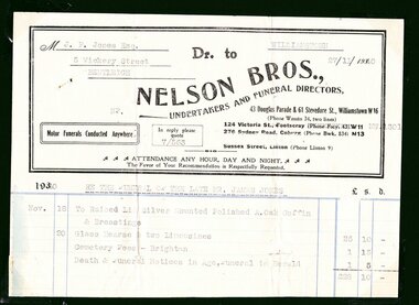
James Jones was the son of Philip Jones, a Chairmaker, and Ann Jones who settled in East Brighton after the sale of land c1852 in the area of the Henry Dendy Special Survey of 1841. Mary Ann Moore was the daughter of Thomas Moore, a Gardener, and Sarah Harris who also settled in Brighton c1852. James and Mary Ann Jones settled and raised their family in East Brighton now Bentleigh. Mr John Herron resided at 4 Vickery St Bentleigh until 1989. Sadly Martha Jones born 1888 died in 1890 and James Jones had to purchase a plot at Brighton General Cemetery for her burial. Baby Ethel May was interred in 1893 and then Mary Ann in 1903 and finally James in 1940. Their stillborn baby was buried in the Wesleyan public grave in 1900James Jones and Mary Ann Moore were born in Brighton c1857 and c 1859 into pioneer market gardener families in the area of the Dendy Special Survey of 1841. They married in 1883 and raised their family in East Brighton, now Bentleigh. Sadly infectious diseases took the lives of many infants throughout the Colony of Victoria due to the poor state of water supply and sewerage disposal and locally the swamps of the Elster Creek were a constant breeding ground. Martha Jones born 1888 died 1890 and was interred in the Brighton General Cemetery in a family plot, in the Wesleyan Section, purchased by her father James Jones. In 1893 another daughter Ethel May died and was buried in the family plot. A stillborn baby was interred in the public grave of Brighton General Cemetery in May1900. Mary Ann Jones died, at age 43years, and was interred in January 1903. Finally in November 1940 Mr James Jones was buried in the family grave. 1 original paper account and 1 paper receipt from Nelson Bros. Funeral Directors re the funeral of James Jones in November 19401) M..J.P Jones Esq./ 5 Vickery Street/ Bentleigh / WILLIAMSTOWN/ 27/11/1940 Dr to / NELSON BROS.,/UNDERTAKERS AND FUNERAL DIRECTORS, / 43 Douglas Parade & 51 Stevedore St., Williamstown W16 / Motor Funerals Conducted Anywhere / In reply please quote 7/563/ Re The Funeral of The Late MR. JAMES JONES/ £28:10:0 -1 Glass Hearse & 2 Limousines, Cemetery Fees and Newspaper notices 2) As above / 27/111940 / A Memo. from NELSON BROS.,/ Dear Sir, /Herewith ...our official receipt... / signed A Nelson / Manager* wesleyan church, brighton general cemetery, vaccination, pioneers, early settlers, typhoid, brighton, moorabbin, bentleigh, market gardeners, jones james, jones mary ann, jones martha, dendy henry, dendys special survey 1841, infectious diseases, water supply, elster creek, melbourne, orford g h, printers, southern cross office, “brighton leader” print, bay street brighton, jones ethel may -
 City of Moorabbin Historical Society (Operating the Box Cottage Museum)
Document - Wedding Certificate, Elizabeth Jones, c1917
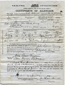
James Jones was the son of Philip Jones, a Chairmaker, and Ann Jones who settled in East Brighton after the sale of land c1852 in the area of the Henry Dendy Special Survey of 1841. Mary Ann Moore was the daughter of Thomas Moore, a Gardener, and Sarah Harris who also settled in Brighton c1852. James and Mary Ann Jones settled and raised their family in East Brighton now Bentleigh. They sadly lost Martha Jones born 1888 died in 1890 ,and. Baby Ethel May died 1893 and a stillborn baby was buried in 1900. However, their daughter Elizabeth Ann Jones born 1885 married John Patrick Kennedy born 1885, a the son of Thomas Kennedy , Dairyman deceased, and Jane Donovan early settlers in the Brighton area, at South Melbourne in January 1917 . James Jones and Mary Ann Moore were born in Brighton c1857 and c 1859 into pioneer market gardener families in the area of the Dendy Special Survey of 1841. They married in 1883 and raised their family in East Brighton, now Bentleigh. Sadly infectious diseases took the lives of many infants throughout the Colony of Victoria due to the poor state of water supply and sewerage disposal and locally the swamps of the Elster Creek were a constant breeding ground. Martha Jones born 1888 died 1890 and was interred in the Brighton General Cemetery. In 1893 another daughter Ethel May died and stillborn baby in May1900. Mary Ann Jones died, at age 43years, in January 1903 and in November 1940 Mr James Jones was buried in the family grave. Their daughter Elizabeth Ann Jones , born 1885, married John Patrick Kennedy, born 1885, the son of Thomas Kennedy, a dairyman and Jane Donovan also early settlers in Brighton area at St Luke’s Anglican Church in South Melbourne in January 1917 Original Certificate of Marriage of Elizabeth Ann Jones, the daughter of James and Mary Ann Jones, to John Patrick Kennedy at St Luke's Anglican Church in South Melbourne on January 1st 1917In the State of Victoria/ crest/ In the Commonwealth of Australia/FOURTH SCHEDULE ACTSNOS. 2691 and 2720 -FORM B/ CERTIFICATE OF MARRIAGE B/ Year 1917Parish or Church District South Melbourne Denomination Church of England/ signed by Patrick Kennedy and Elizabeth Jones, witnesses Ada Hewton and Alice Steedman and Vicar David Ross Hewton dated this first day of January 1917anglican church, st luke's south melbourne, jones elizabeth ann, kennedy john patrick, kennedy thomas, donovan jane, dairyman, dairy farms, brighton general cemetery, vaccination, pioneers, early settlers, typhoid, brighton, moorabbin, bentleigh, market gardeners, jones james, jones mary ann, jones martha, dendy henry, dendys special survey 1841, infectious diseases, water supply, elster creek, melbourne, jones ethel may, reverend hewton david ross -
 The Beechworth Burke Museum
Geological specimen - Slice Dendrites on Sandstone, Unknown
Dendrites are deposits of black minerals, typically manganese oxides that precipitated from water seeping through fractures in fine-grain rocks like a sandstone or limestone. Dendrites are much less regular than plant fossils and lacks vein structures. The manganese cryztallizes through the process called 'supercooling'. Some samples of dendrites occur in volcanic rocks in the Lilydale district, east of Melbourne. Sandstones are made of tiny sand grains that may have been deposited in the sea and later formed together. Most sandstones are made of quartz which are chemically-resistant minerals. This particular specimen was donated by Alfred Selwyn in 1868 as part of the Geological Survey of Victoria. It is connected to the original 1875 catalogue on Geological Specimen with number 189 'Quartz Crystals_Quartz Crystals (two are polished)'Dendrites on sandstones This specimen is an important contribution to the geological history of Victoria, as well as its links to the 1868 Geological Survey of Victoria. This specimen is part of larger collection of significant geological specimens in the Burke Museum that was collected from around the world between 1868-1880. A large percentage of these specimens were collection as part of the Geological Survey of Victoria 1852-1974. The Geological Survey of Victoria was an organisation founded in response to the Victorian gold rush to explore the geological and mineral resources and to record a detailed map of the state. It was headed by British geologist, Alfred Richard Cecil Selwyn (1824-1902), who was responsible for issuing over 60 geological maps during his 17 years as director. These maps were all hand-drawn and coloured and became the benchmark for accuracy for geological mapping. Collecting geological specimens was an important part of mapping and understanding the scientific makeup of the earth. Many of these specimens were sent to research and collecting organisations across Australia, including the Burke Museum, to educate and encourage further study. A hand-sized slice of light brown sandstone with dendrites formed from crystallized manganese oxide.Existing label: Not sure what / 'Slica dondrites' / means. / Sample is sandstone and original label / identifies it as from / the Grampians near Stawell. / C. Willman / 15/4/21 Other label: [illegible] / stone [ illegible] / from Grampians Stawell / 1894 /geological specimen, geology, geology collection, burke museum, beechworth, dendrites, sandstones, quartz, lilydale district, geological survey of victoria, grampians, victoria rocks, minerals, rocks, manganese oxides, alfred selwyn -
 Federation University Historical Collection
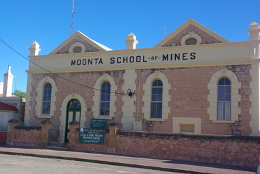
Book, Moonta School of Mines Annual Report, 1903, 1905
The Moonta School of Mines was intended for students who wanted to increase their knowledge of those arts and sciences which were especially important to miners and others similarly engaged. The School had subsidiary classes at Wallaroo Mines. It was the only institution on the Yorkes Peninsula furnishing technical education The School was situated close to the Moonta Mines, at that time the most important copper mines in Australia. The the mines students were able to acquire practical knowledge of the work of a miner. The close by smelting works at Wallaroo were seen to be of great service to those wanting to become acquainted with chemistry and metallurgy. Subjects taught at the Moonta School of Mines included Chemistry, Metallurgy, Steam and the Steam Engine, Magnetism and Electricity, Mathematics, Machine Design, Mine Surveying and Leveling, Drawing, Plumbing and Sheet Metal Work.Grey soft coloured book with images of the interior of the Moonta School of Mines in South Australia, and members of Council .moonta, moonta school of mines, rogers, mueller, pomroy, martin, blatchford, richardson, brown, potter, w. peter hughes, ricky hains, henry lipson hancock, henry richard hancock, r.e. hancock, david james, edwin martin, bessie poole, kim potter, james richardson, g. warrington rogers, t. cooke and sons, g. ulrich, schools of mines, wallaroo, billy muir, south australia -
 Federation University Historical Collection
Book - Annual Report 1880, The School of Mines Ballaarat Annual Report, 9 February, 1880
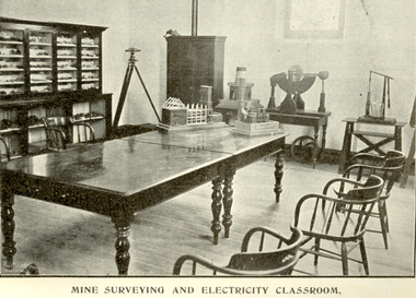
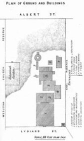
The School of Mines Annual Report, 9 February, 1881, Additional Examination Statute 1880, Balance Sheet, Certificates Granted by Council, Donations and Fees - carriage of, Extracts from Visitors' Book, Fees, Form of Bequest, Honorary Correspondents, Life Governors, Mining and Mineral Contributions Invited - Paper of Particulars, Museum - open to visitors, Office Bearers, Obituary, Report of the Lecturer in Mathematics, Report of the Lecturer in Mining-Land- and Engineering-Surveying, Report of the Lecturer in Mechanical Engineering, Report of the Lecturer in Telegraphy, Report of the Curator of the Museum (with Plans), Report of the Superintendent of Laboratories, Subjects and Lecturers, Subjects and Examiners, Statement of Receipts and Expenditure for the year 1880, Subscriptions and Donations from 1 January to 31 December 1880, The Lal-Lal Iron Ore Deposits - (with Section and Plan)Pale green booklet of 70 pages, Annual Report 1880. Image of Guage Test Tower, Image of The School of Mines, Plan of Ground and Buildings - Albert Street, The School of Mines Ballaarat - The Museum - Plan of Groundfloor, Image of the Lal-Lal Iron Ore Deposits, Moorabool Riverthe school of mines, annual report, additional examination statute 1880, balance sheet, certificates granted by council, donations and fees - carriage of, extracts from visitors' book, fees, form of bequest, honorary correspondents, life governors, mining and mineral contributions invited-paper of particulars, museum open to visitors, office bearers, obituary, report of the lecturer in mathematics, report of the lecturer in mining-land and engineering-surveying, report of the lecturer in mechanical engineering, report of the lecturer in telegraphy, report of the curator of the museum (with plans), report of the superintendent of laboratories, subjects and lecturers, subjects and examiners, statement of receipts and expenditure for the year 1880, subscriptions and donations from 1 january to 31 december 1880, the lal-lal iron ore deposits-(with section and plan), obituary - sir redmond barry - arthur leahy - jacob upfold - john day, mr james oddie, dr. r. f. hudson, john victor, chas. wm. thomas, w. h. shaw, walter d. campbell, ferdinand m. krause, joseph flude, geo. perry, w. hy. barnard, examination statute, his excellency sir wm. f. drummond jervois, charles h. pearson, t. brodribb, professor pepper, james mitchell, robert adam, wm. lant carperter, h. b. de la poer wall, w. h. brokenshire, arthur parker, henry parkinson, c. davies, simon richards, c. v. gorton, c. r. blackett, david jones, wilberforce dyke, ferdinand krause, ballarat school of mines museum, ballarat school of mines museum plan, lal lal ore deposits, moorabool river, william land carpenter, william jervois, william henry tbarnard -
 Warrnambool and District Historical Society Inc.
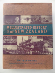
Book, Illustrated history of New Zealand, 2004
This is an illustrated history of New Zealand. Since the foundation of Warrnambool in 1847 up to the present day there has been regular and important contact between the people of Warrnambool and New Zealand. In the 19th and early 20th centuries many people in Warrnambool moved either temporarily or permanently to New Zealand for marriage or economic reasons. Some residents of Warrnambool and district were involved in the Maori Wars and there was regular shipping between the two places with much timber imported from New Zealand, especially for the McGennan butter box factory and for building purposes (e.g. St. Joseph’s Church). The builder of theWarrnambool Breakwater, Arthur Dudley Dobson, came to Warrnambool after having practised his surveying and engineering skills in New Zealand (South Island – Trans Alpine Railway etc). This book is very useful for research into the Warrnambool/New Zealand connection, especially in the 19th century. There is information in this book on Arthur Dudley Dobson who was important in the history of both Warrnambool and New Zealand. This is a hard cover book of 488 pages. The cover is green with gold lettering on the front and spine. There is also a dust cover with a brown and green background with gold and green lettering and sepia-coloured photographs on the front and back covers. The book has illustrations from the Alexander Turnbull Library, an introduction, ten chapters of text, notes, glossary, bibliography and index. new zealand, arthur dudley dobson, history of warrnambool -
 Warrnambool and District Historical Society Inc.
Letter book 13, 1920
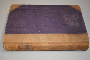
This letter book contains letters, sketch maps and plans and dates from 1920 to 1923. It came from the office of John William Crawley Junior, an engineer, architect and surveyor in private practice in Warrnambool and also the engineer for the Shire of Warrnambool from 1895 to 1935. His father, brother and son were also engineers and worked in that capacity or as the Shire Secretary for the Shire of Warrnambool, with the Crawley family recording a total of 132 years of service to the Shire. The letter book was passed onto John Crawley’s son, Rolf, the engineer for the Shire of Warrnambool from 1935 to 1968. It then came into the possession of Michael Hand who took over the private surveying business on Rolf Crawley in Warrnambool. The Warrnambool and District Historical Society acquired the letter book, along with several other Crawley ledgers, from the estate of Michael Hand. This letter book is of considerable significance as it contains letters and maps drawn up by John William Crawley, an engineer in the Shire of Warrnambool for 40 years. It will be very useful for researchers.This is a dark red hard- cover letter book of 1001 pages. The book has brown binding on the corners of the cover and on the spine. There is gold lettering on the spine. The inside of the cover is lined with a multi-coloured mottled pattern. The cover is stained and scuffed. The pages contain handwritten letters, sketch maps and plans and an alphabetical index at the front. There are three loose pages. There is a mauve stamp on the first page.‘Letter Book 1920 to 1923’ ‘Rolf. L. Crawley Civil Engineer, Drainage and Water Supply Engineer, Licensed Surveyor, Registered Architect, Warrnambool’ john william crawley junior, warrnambool, rolf crawley, warrnambool, shire of warrnambool -
 Warrnambool and District Historical Society Inc.
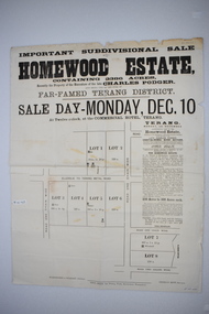
Original document, Advertising "Homewood Estate" Terang, 1886
This notice advertises the sale of the Homewood property near Glenormiston. The sale details state that the property is 2386 acres adjoining "The Sisters" the station of the Black Brothers. The property lies on the main metal road from Terang to Ellerslie, six miles from Terang. It has frontage to Pejark Marsh/drain. It was to be surveyed and sold in blocks of 250 to 300 acres with permanent water and well covered with grasses. The sale of the property followed the death of Charles Podger who died in 1886. On his death he left his wife Ann and six children.His worth was over 20000 pounds with 16000 pounds as real estate and 4300 pounds in personal propertyThe Agent for the sale was James Jellie, solicitors were Warrnambool firm Klingender and O'Mahony and the advertisement was printed by Thomas Smith Gas printing Works Warrnambool. This document has local interest and significance as an early sales of land in the district. The names of agents , solicitors and printers were wll known in the area and the property also a large holding. The Podger name is also well represented in the district to this day.Large white rectangular sheet of paper with black text . Major sale details in heavy black text at the top with descriptive text accompanying map of subdivision of the property on the left.The following names and details are contained within the document. Homewood Estate, Charles Podger, Commercial Hotel Terang, James Jellie Fenelon Mott Surveyor, Klingender & O'Mahony solicitors, Thos, Smith Gas Printing Koroit Street Warrnamboolcharles podger, homewood estate, klingender, o"mahony, kolora, the sisters, terang -
 Orbost & District Historical Society
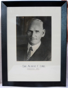
framed photo, APFA- Davisigns (PG & ME Davis)
This photo was inherited with the building when the museum was established. Lind was born in 1878 in East Charlton, Victoria, the son of Oliver Nicholas Lind, a farmer from Denmark, and his Welsh wife Mary Ann Clay. In 1882, drought forced the family to move to East Gippsland where Lind was educated at Lucknow, and then to Bairnsdale in 1884 where he attended Bairnsdale state school. In October 1920, he was elected to the Victorian Legislative Assembly for the seat of Gippsland East for the Victorian Farmers' Union. Lind was made Minister of Forests, President of the Board of Land and Works and Commissioner of Crown Lands and Survey in Albert Dunstan's cabinet. He was knighted in 1951. In 1926 two national parks east of Orbost were named the Albert and the Lind national parks after him.A framed photo of Sir Albert Eli Lind. It is a black and white head and shoulders photo in a black wooden frame.Sir Albert E. Lind Knighted !951photograph politician lind-albert government -
 Eltham District Historical Society Inc
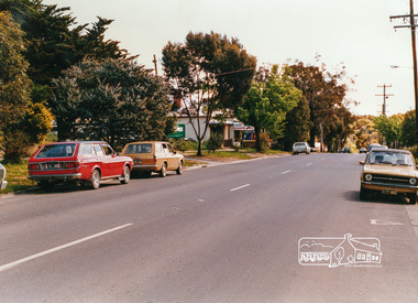
Photograph, Looking west near 942 Main Road, Hurstbridge, c. Oct 1987, 1987
Yvonne's Dressmaking and Alteration Service at 942 Main Road. Formerly a bakery, the building was demolished in 1990 and is now the site of Hurstbridge Saddlery. The milkbar is down the road, brick wall with a blue sign on it. There's still an older house next to the milkbar, but that's hidden from view in this shot as it's further back from the road. Date based on other similar display panels visible in images of the Shire of Eltham display at the Eltham Community Festival, 7 November 1987. Shire of Eltham Engineering Department Providing the resources to undertake • Survey, design, consultation • Road construction and maintenance • Bridge construction and maintenance • Street sweeping • Drain and pit cleaning • Traffic engineering installation and maintenance • Garbage collection • Tip management, land reclamation and beautification • Maintenance of community buildings • Provision of community and recreation facilitiesPhoto print mounted on carddisplay panel, eltham festival, heidelberg-kinglake road, hurstbridge, hurstbridge milk bar, infrastructure, main road, mm, shire of eltham, yvonne's dressmaking and alteration service -
 Eltham District Historical Society Inc
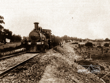
Negative - Photograph, Railway construction train hauled by steam locomotive W-197 between Eltham and Hurstbridge, c.1912
The locomotive was built by the American Baldwin Locomotive works in 1880 and was converted to a W class engine by the Phoenix Foundry at Ballarat in 1882. Agitation for a railway extension began in 1888 when a meeting was held at Arthurs Creek to press for the construction of a railway line from Heidelberg to Kinglake. The Chairman Mr Charles Draper said this was necessary because this was the best fruit growing district in Victoria. Mr Cameron M.P. pointed out that whatever route the line took it would have to follow the Diamond Valley from Eltham. At the same time another meeting was pressing for the line to be extended to Queenstown (St Andrews). However when detailed surveys were made it was discovered that the only possible route was to Hurstbridge because of the hills. In 1912 the railway was opened terminating at Hurstbridge. Roll of 35mm colour negative film, 4 stripsKodak Safety 5035steam train, w-197, railway construction, steam locomotive -
 Victorian Interpretive Projects Inc.
Photograph - colour, Clare Gervasoni, Moonta School of Mines, 25/06/2013
Opening in 1891 the Moonta School of Mines was intended for students who wanted to increase their knowledge of those arts and sciences which were especially important to miners and others similarly engaged. The School was situated close to the Moonta Mines, at that time the most important copper mines in Australia, and the smelters at Wallaroo. The the mines students were able to acquire practical knowledge of the work of a miner. The close by smelting works at Wallaroo were seen to be of great service to those wanting to become acquainted with chemistry and metallurgy. Subjects taught at the Moonta School of Mines included Chemistry, Metallurgy, Steam and the Steam Engine, Magnetism and Electricity, Mathematics, Machine Design, Mine Surveying and Leveling, Drawing, Plumbing and Sheet Metal Work. The Moonta School of Mines building in Ellen Street was formerly Baptist Church.Stone building used as the Moonta School of Mines. This image can be compared to a 1904 image at http://victoriancollections.net.au/items/519c24142162ef13f0648d42 moonta, school of mines, mining -
 Wodonga & District Historical Society Inc
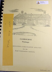
Booklet - Cambourne Wodonga : Conservation & Relocation Analysis for the Road Construction Authority, John & Thurley O'Conner, 1987
Research paper into the viability of relocating Cambourne Homestead in 2006 in order to make way for the widening and upgrade of the Hume Highway.non-fictionResearch paper into the viability of relocating Cambourne Homestead in 2006 in order to make way for the widening and upgrade of the Hume Highway. cambourne homestead wodonga, heritage building wodonga, carkeek family, potter family, building relocation -
 Federation University Art Collection
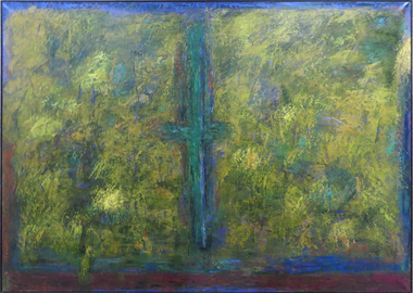
Painting, Wright, Doug, 'Wattle Ridge' by Doug Wright, 2003
Doug WRIGHT (1944 - ) Born Ballarat Doug Wright studied at the Ballarta School of Mines Art School between 1963 and 1964, followed by studies at the Royal Melbourne Institute of Technology from 1965 to 1966, resulting in a Diploma of Art (Fine Art Painting). Since 1974 Doug Wright has had over 20 solo exhibitions and a survey exhibition in 1993 which travelled Victorian Regional Galleries. From 1975 to 2009 Doug Wright was Lecturer in Painting at State College of Victoria (Ballarat) and University of Ballarat. This item was commissioned for the entrance of the new Administration Building at Mount Helen by the Director of Ballarat University College, is part of the Federation University Art Collection. The Art Collection features over 2000 works and was listed as a 'Ballarat Treasure' in 2007.art, artwork, doug wright, wright, oil painting, painting -
 Federation University Art Collection
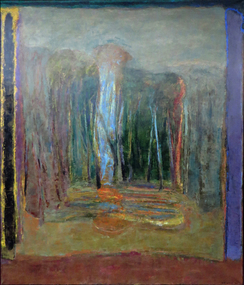
Painting - Artwork, Wright, Doug, 'The Seasons - Mt Helen' by Doug Wright, 1993
Doug WRIGHT (1944 - ) Born Ballarat Doug Wright studied at the Ballarta School of Mines Art School between 1963 and 1964, followed by studies at the Royal Melbourne Institute of Technology from 1965 to 1966, resulting in a Diploma of Art (Fine Art Painting). Since 1974 Doug Wright has had over 20 solo exhibitions and a survey exhibition in 1993 which travelled Victorian Regional Galleries. From 1975 to 2009 Doug Wright was Lecturer in Painting at State College of Victoria (Ballarat) and University of Ballarat. This item was commissioned for the entrance of the new Administration Building at Mount Helen by the Director of Ballarat University College, is part of the Federation University Art Collection. The Art Collection features over 2000 works and was listed as a 'Ballarat Treasure' in 2007.Abstract landscape with vertical lineal components.art, artwork, doug wright, landscape -
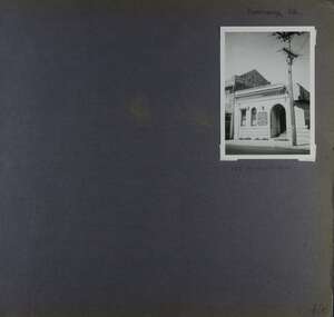 Glen Eira Historical Society
Album - Album page, Koornang Road, Circa 1972
This photograph is part of the Caulfield Historical Album 1972. This album was created in approximately 1972 as part of a project by the Caulfield Historical Society to assist in identifying buildings worthy of preservation. The album is related to a Survey the Caulfield Historical Society developed in collaboration with the National Trust of Australia (Victoria) and Caulfield City Council to identify historic buildings within the City of Caulfield that warranted the protection of a National Trust Classification. Principal photographer thought to be Trevor Hart, member of Caulfield Historical Society. Most photographs were taken between 1966-1972 with a small number of photographs being older and from unknown sources. All photographs are black and white except where stated, with 386 photographs over 198 pages. 1970 Sands & McDougall Directory shows UFS Dispensary at address.Page 106 of Photograph Album with one photograph (portrait) of a pharmacy on Koornang Road.Handwritten: Koornang Rd [top right] / 162 KOORNANG RD [under photo] / 106 [bottom right]trevor hart, koornang road, carnegie, rosstown, dispensary, pharmacies, shops, commercial establishments, ufs dispensary, arches -
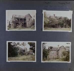 Glen Eira Historical Society
Album - Album page, Royston, Kooyong Road, Circa 1972
This photograph is part of the Caulfield Historical Album 1972. This album was created in approximately 1972 as part of a project by the Caulfield Historical Society to assist in identifying buildings worthy of preservation. The album is related to a Survey the Caulfield Historical Society developed in collaboration with the National Trust of Australia (Victoria) and Caulfield City Council to identify historic buildings within the City of Caulfield that warranted the protection of a National Trust Classification. Principal photographer thought to be Trevor Hart, member of Caulfield Historical Society. Most photographs were taken between 1966-1972 with a small number of photographs being older and from unknown sources. All photographs are black and white except where stated, with 386 photographs over 198 pages. Vol 1 of 4 "Caulfield's Heritage" p34 states that this mansion was demolished in 1972.Page 114 of Photograph Album with four colour photographs (landscape) of different views of Royston in its garden.Handwritten: "Royston" Kooyong Road / 240 KOOYONG ROAD / 1939 - SLATTER - MISS MAY EDITH ALICE. [top right] / 114 [bottom right]trevor hart, caulfield north, kooyong road, 1860's, villa residence, victorian, mansion, ornamented corner stones, royston, renwick, curved windows, timber verandahs, return verandahs, bay windows, may edith alice slatter, may slatter, balconies, polychrome bricks, abandoned buildings -
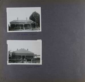 Glen Eira Historical Society
Album - Album page, Murray Street, Circa 1972
This photograph is part of the Caulfield Historical Album 1972. This album was created in approximately 1972 as part of a project by the Caulfield Historical Society to assist in identifying buildings worthy of preservation. The album is related to a Survey the Caulfield Historical Society developed in collaboration with the National Trust of Australia (Victoria) and Caulfield City Council to identify historic buildings within the City of Caulfield that warranted the protection of a National Trust Classification. Principal photographer thought to be Trevor Hart, member of Caulfield Historical Society. Most photographs were taken between 1966-1972 with a small number of photographs being older and from unknown sources. All photographs are black and white except where stated, with 386 photographs over 198 pages. 63 and 117 Murray Street houses are extant (Google maps image capture Dec 2018).Victorian Heritage Database - HO131 63 Murray Street Caulfield https://vhd.heritagecouncil.vic.gov.au/places/35569 (as of 14/08/2021) "Marston" at no. 63 Murray Street, Caulfield South, was built by J.E. Guest, a contractor resident in nearby Downshire Road, in 1889-90, presumably as a speculative venture together with the extant house at adjoining No.61. It is aesthetically significant. It is aesthetically significant (Criterion E) as an exceptionally richly ornamented medium sized Boom period villa in Caulfield South, being unusual in this respect in its locale and comparing with nearby "Sprouston" at 19 Blanche Street (1887). Important contributory elements include the polychrome brickwork, frieze and verandah including the half timbered gablet which would have been stylistically innovative in its day.Page 139 of Photograph Album with two landscape photographs of two different houses in Murray Street. Handwritten: 63 MURRAY STREET [under top photo] / 117 MURRAY STREET [under bottom photo] / 139 [bottom left]trevor hart, garden, verandah, murray street, elsternwick, victorian style, houses, marston, house names, j e guest, verandahs, polychrome bricks, cast iron work, chimneys -
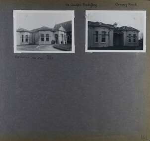 Glen Eira Historical Society
Album - Album page, St Joseph's Presbytery, Orrong Road, Circa 1972
This photograph is part of the Caulfield Historical Album 1972. This album was created in approximately 1972 as part of a project by the Caulfield Historical Society to assist in identifying buildings worthy of preservation. The album is related to a Survey the Caulfield Historical Society developed in collaboration with the National Trust of Australia (Victoria) and Caulfield City Council to identify historic buildings within the City of Caulfield that warranted the protection of a National Trust Classification. Principal photographer thought to be Trevor Hart, member of Caulfield Historical Society. Most photographs were taken between 1966-1972 with a small number of photographs being older and from unknown sources. All photographs are black and white except where stated, with 386 photographs over 198 pages. St Joseph's buildings and grounds are contributory properties to HO72 Elsternwick Estate and environs - City of Glen Eira.Page 162 - two photographs of St Joseph's Presbytery, Orrong Road.Handwritten: St Joseph's Presbytery Orrong Road [top right] / PREVIOUSLY "THE EMS" 1908 [under left photo] / 162 [bottom right]trevor hart, orrong road, curved windows, decorative brackets, arched windows, bay window, portico, slate roof, st joseph's presbytery, catholic church, st joseph's church, st joseph's primary school, porte cochere, the ems, elsternwick, rendered walls, clergy residences, drives, late victorian style, house names -
 Glen Eira Historical Society
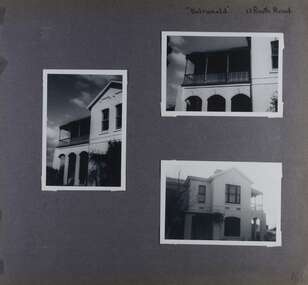
Album - Album page, Balranald, Poath Road, Circa 1972
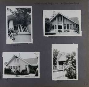
This photograph is part of the Caulfield Historical Album 1972. This album was created in approximately 1972 as part of a project by the Caulfield Historical Society to assist in identifying buildings worthy of preservation. The album is related to a Survey the Caulfield Historical Society developed in collaboration with the National Trust of Australia (Victoria) and Caulfield City Council to identify historic buildings within the City of Caulfield that warranted the protection of a National Trust Classification. Principal photographer thought to be Trevor Hart, member of Caulfield Historical Society. Most photographs were taken between 1966-1972 with a small number of photographs being older and from unknown sources. All photographs are black and white except where stated, with 386 photographs over 198 pages. Originally named Crofthead or The Croft Head, later changed to Balranald according to Melbourne Mansions database.From Victorian Heritage Database citation for HO136 13 Poath Street MURRUMBEENA https://vhd.heritagecouncil.vic.gov.au/places/35389 as at 30/10/2020 "Croft Head" is situated at no. 13 Poath Road, Murrumbeena, and was built in 1887 for the accountant Edward Tweddell. It is historically and aesthetically significant. It is historically significant (Criterion A) as a substantial and now rare (Criterion B) surviving late Victorian villa residence east of Booran Road within the Municipality and demonstrating the attraction of Melbourne's rural fringe as a residential location rendered accessible by the opening of the railway between South Yarra and Oakleigh in 1879. It is aesthetically significant (Criterion E) as one of the Municipality's finest late Victorian polychrome brick villas, comparing with ''Fresch'' and ''Monkleigh'' both erected in 1899 at nos. 11 and 12 Gladstone Parade, Elsternwick respectively, ''Hartington'' (1888) at 15 Gladstone Parade and ''Hengar'' (1889) at no. 356 Glen Eira Road, Caulfield South. Elements of stylistic significance include the ornamentation of the brickwork in polychrome work with tiled panels, the effect of the banding being especially striking and representative of the period.Page 166 of Photograph Album with three photographs of Balranald on Poath Road.Handwritten: "Balranald" 13 Poath Road [top right] / 166 [bottom right]trevor hart, decorative brackets, chimneys, verandah, porch, poath road, arches, cast iron columns, return verandah, croft head, balranald, victorian villa, restoration, 1880's, edward tweddell, murrumbeena, hughesdale, cast iron frieze, victorian style, cast iron work, rendered brick, house names, polychrome brick, poath street, crofthead, the croft head -
 Glen Eira Historical Society
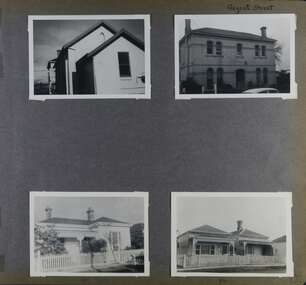
Album - Album page, Regent Street, Circa 1972
This photograph is part of the Caulfield Historical Album 1972. This album was created in approximately 1972 as part of a project by the Caulfield Historical Society to assist in identifying buildings worthy of preservation. The album is related to a Survey the Caulfield Historical Society developed in collaboration with the National Trust of Australia (Victoria) and Caulfield City Council to identify historic buildings within the City of Caulfield that warranted the protection of a National Trust Classification. Principal photographer thought to be Trevor Hart, member of Caulfield Historical Society. Most photographs were taken between 1966-1972 with a small number of photographs being older and from unknown sources. All photographs are black and white except where stated, with 386 photographs over 198 pages. At least 2 of these houses (17 and 84) are contributory properties to HO72 Elsternwick Estate and environs.Page 172 of Photograph Album with four photographs of differerent properties on Regent Street.Handwritten: Regent Street [top right] / 17 [under bottom left photo] / 84 [under bottom right photo] / 172 [bottom right]trevor hart, regent street, elsternwick, houses, mansions, cast iron work, verandahs -
 Glen Eira Historical Society
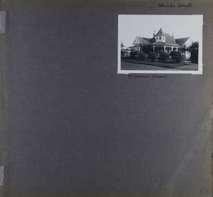
Album - Album page, Wanda Street, Circa 1972
This album was created in approximately 1972 as part of a project by the Caulfield Historical Society to assist in identifying buildings worthy of preservation. The album is related to a Survey the Caulfield Historical Society developed in collaboration with the National Trust of Australia (Victoria) and Caulfield City Council to identify historic buildings within the City of Caulfield that warranted the protection of a National Trust Classification. Principal photographer thought to be Trevor Hart, member of Caulfield Historical Society. Most photographs were taken between 1966-1972 with a small number of photographs being older and from unknown sources. All photographs are black and white except where stated, with 386 photographs over 198 pages. House still in place per Google image capture June 2019. It is Wanda Road, not street. Page 198 of Photograph Album with one photograph of a house on Wanda Street.Handwritten: Wanda Street [top right] / 19 WANDA STREET [under photo] / 198 [bottom right]trevor hart, porch, garden, verandah, single storey, return verandah, decorative brackets, wanda street, ridge capping, spire, protruding bays, decorative fretwork, queen anne style, queen anne, conical tower, wanda road, caulfield north -
 Glen Eira Historical Society
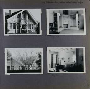
Album - Album page, Balaclava Road, 45, Circa 1972
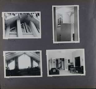
This photograph is part of the Caulfield Historical Album 1972. This album was created in approximately 1972 as part of a project by the Caulfield Historical Society to assist in identifying buildings worthy of preservation. The album is related to a Survey the Caulfield Historical Society developed in collaboration with the National Trust of Australia (Victoria) and Caulfield City Council to identify historic buildings within the City of Caulfield that warranted the protection of a National Trust Classification. Principal photographer thought to be Trevor Hart, member of Caulfield Historical Society. Most photographs were taken between 1966-1972 with a small number of photographs being older and from unknown sources. All photographs are black and white except where stated, with 386 photographs over 198 pages. While the page heading says "architect: Walter Burley Griffin", in fact Edward F. Billson designed it.From the Victorian Heritage Register Database - Citation for 45 Balaclava Road https://vhd.heritagecouncil.vic.gov.au/places/35562 (as at 12/10/2020) The house at 45 Balaclava Road, Caulfield North has architectural importance as an early example of the work of Edward F. Billson, whose work demonstrated the influence of the internationally distinguished American architect Frank Lloyd Wright and his one time colleague, Walter Burley Griffin with whom Billson worked in partnership for a period. It is presumed to be the earliest important example Billson's work and attains special importance as an early example of modern architecture in Australia, the earliest work of Griffin preceding it by only five years.Page 28 of Photograph Album with four photographs - two interior and two exterior photographs.Hand written: 45 Balaclava Rd architect Walter Burley Griffin [top right] / Neg 265 [under top right photo] / Neg 266 [under right bottom photo] / 28[bottom right]trevor hart, caulfield north, balaclava road, edward f. billson, frank lloyd wright, walter burley griffin, modern architecture, 1910's, gables, double storey houses, attics, windows -
 Glen Eira Historical Society
Album - Album page, Balaclava Road, 45, Circa 1972
This photograph is part of the Caulfield Historical Album 1972. This album was created in approximately 1972 as part of a project by the Caulfield Historical Society to assist in identifying buildings worthy of preservation. The album is related to a Survey the Caulfield Historical Society developed in collaboration with the National Trust of Australia (Victoria) and Caulfield City Council to identify historic buildings within the City of Caulfield that warranted the protection of a National Trust Classification. Principal photographer thought to be Trevor Hart, member of Caulfield Historical Society. Most photographs were taken between 1966-1972 with a small number of photographs being older and from unknown sources. All photographs are black and white except where stated, with 386 photographs over 198 pages. While the page heading says "architect: Walter Burley Griffin", in fact Edward F. Billson designed it.From the Victorian Heritage Register Database - Citation for 45 Balaclava Road https://vhd.heritagecouncil.vic.gov.au/places/35562 (as at 12/10/2020) The house at 45 Balaclava Road, Caulfield North has architectural importance as an early example of the work of Edward F. Billson, whose work demonstrated the influence of the internationally distinguished American architect Frank Lloyd Wright and his one time colleague, Walter Burley Griffin with whom Billson worked in partnership for a period. It is presumed to be the earliest important example Billson's work and attains special importance as an early example of modern architecture in Australia, the earliest work of Griffin preceding it by only five years.Page 29 of Photograph Album with four photographs of close up views of architectural details of a window and doors including three interiors and one exterior view.Hand written: Neg 263 [under top left photo] / Neg 269[under top right photo] / Neg 261 [under bottom left photo] / Neg 267 [under bottom right photo] / 29 [bottom left]trevor hart, caulfield north, balaclava road, edward f. billson, frank lloyd wright, walter burley griffin, modern architecture, 1910's, gables, double storey houses, windows -
 Glen Eira Historical Society
Album - Album page, Balaclava Road, 45, Circa 1972
This photograph is part of the Caulfield Historical Album 1972. This album was created in approximately 1972 as part of a project by the Caulfield Historical Society to assist in identifying buildings worthy of preservation. The album is related to a Survey the Caulfield Historical Society developed in collaboration with the National Trust of Australia (Victoria) and Caulfield City Council to identify historic buildings within the City of Caulfield that warranted the protection of a National Trust Classification. Principal photographer thought to be Trevor Hart, member of Caulfield Historical Society. Most photographs were taken between 1966-1972 with a small number of photographs being older and from unknown sources. All photographs are black and white except where stated, with 386 photographs over 198 pages. While the page heading says "Walter Burley Griffin arch", in fact Edward F. Billson designed it.From the Victorian Heritage Register Database - Citation for 45 Balaclava Road https://vhd.heritagecouncil.vic.gov.au/places/35562 (as at 12/10/2020) The house at 45 Balaclava Road, Caulfield North has architectural importance as an early example of the work of Edward F. Billson, whose work demonstrated the influence of the internationally distinguished American architect Frank Lloyd Wright and his one time colleague, Walter Burley Griffin with whom Billson worked in partnership for a period. It is presumed to be the earliest important example Billson's work and attains special importance as an early example of modern architecture in Australia, the earliest work of Griffin preceding it by only five years.Page 30 of Photograph Album with three photographs of the exterior of this double storey house and one photograph of a carport.Handwritten: Walter Burley Griffin arch. 45 Balaclava Road [top right] / Neg 272 [under top left photo] / Neg 270 [under top right photo] / Neg 262 [under bottom left photo] / Neg 264 [under bottom right photo] / 30 [bottom right] trevor hart, caulfield north, balaclava road, edward f. billson, frank lloyd wright, walter burley griffin, modern architecture, 1910's, gables, double storey houses, windows, attics, carports, gardens -
 Glen Eira Historical Society
Album - Album page, Glen Huntly Road, Circa 1972
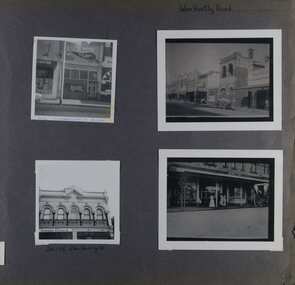
This photograph is part of the Caulfield Historical Album 1972. This album was created in approximately 1972 as part of a project by the Caulfield Historical Society to assist in identifying buildings worthy of preservation. The album is related to a Survey the Caulfield Historical Society developed in collaboration with the National Trust of Australia (Victoria) and Caulfield City Council to identify historic buildings within the City of Caulfield that warranted the protection of a National Trust Classification. Principal photographer thought to be Trevor Hart, member of Caulfield Historical Society. Most photographs were taken between 1966-1972 with a small number of photographs being older and from unknown sources. All photographs are black and white except where stated, with 386 photographs over 198 pages. 376 Glen Huntly Road is a contributory building to HO72 - Elsternwick Estate and Environs, City of Glen Eira.Page 64 of Photograph Album with four photographs of different properties on Glen Huntly Road - 2 in portrait mode and 2 in portrait photographs of photographs.Hand written: Glen Huntly Road [top right] / 376 GLENHUNTLY ROAD [written in blue pen on the bottom edge of the top left photo] / 216-218 Glen Huntly Rd [under bottom left photo] / 64 [bottom right] trevor hart, glen huntly road, elsternwick, shops, streetscapes, vintage cars, carriages and coaches, glenhuntly road -
 Glen Eira Historical Society
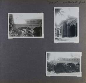
Album - Album page, Glentana, Glen Huntly Road, 805, Circa 1972
This photograph is part of the Caulfield Historical Album 1972. This album was created in approximately 1972 as part of a project by the Caulfield Historical Society to assist in identifying buildings worthy of preservation. The album is related to a Survey the Caulfield Historical Society developed in collaboration with the National Trust of Australia (Victoria) and Caulfield City Council to identify historic buildings within the City of Caulfield that warranted the protection of a National Trust Classification. Principal photographer thought to be Trevor Hart, member of Caulfield Historical Society. Most photographs were taken between 1966-1972 with a small number of photographs being older and from unknown sources. All photographs are black and white except where stated, with 386 photographs over 198 pages. Melbourne Mansions database indicates that its architect may have been Charles Webb.Page 66 of Photograph Album with three exterior photographs (two portrait and one landscape) of Glentana, a single storey Victorian residence, focussing on views of its verandah.Hand written: "Glentana" 805 Glenhuntly Road [top right] / 66 [bottom right] trevor hart, brick, polychrome brickwork, cast iron frieze, decorative brackets, italianate, return verandah, glentana, glen huntly road, caulfield, cast iron work, verandahs, glenhuntly road, charles webb, glen tana, house names