Showing 14639 items matching "j-crofts"
-
 Moorabbin Air Museum
RICHARD J. WAUGH, NEW ZEALAND AVIATION MYSTERY - LOST ... WITHOUT TRACE?, 2005
-
 Ballarat Tramway Museum
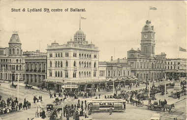
Photograph - Digital image, J. Summerscales and Ballarat, Sturt & Lydiard Sts centre of Ballarat, c1908
Photograph - looking from Summerscales offices onto the intersection of Sturt and Lydiard St during an event, with a parked ESCo tram and crowds or onlookers on either side of the south side of Sturt St. Has a detailed image of the tram. C1909. In the background are Craigs Hotel, C. Marks & Co, National Mutual building, Snows and the Town Hall. A number of horse drawn vehicles are in the photograph. Also A. E. Casley Chemists and Beath Schiess & Co, though this seems to be almost printed into the photograph - above the chemist shop. See item 8247 for a colour image of the same postcard published by SEM Co. Yields information about the streetscape of Sturt St and Lydiard Streets c1908Digital image of a postcard by A. H Summerscalestrams, tramways, sturt st, esco, events, lydiard st -
 Queenscliffe Maritime Museum
Equipment - Ship's compass, J. Priestman & Co. Read more at wrecksite: https://wrecksite.eu/wreck.aspx?57395, 1913
On August 23rd, 1949, S. S. TIME was on voyage from Sydney to Melbourne with a cargo of sugar (3,000 tons), timber, general cargo and coal, when she was wrecked on Corsair Rock, entrance of Port Philip Bay. Read more at wrecksite: https://wrecksite.eu/wreck.aspx?57395The S.S. Time was a land mark vessel in Queenscliff and surrounding areas from August 23rd, 1949, when it was wrecked on Corsair Rock in the entrance of Port Philip Bay until the early 60s when it broke up in a storm.A brass Compass from SS Time mounted on a wooden frameNo 857 E Easdailess time, compass -
 Bayside Gallery - Bayside City Council Art & Heritage Collection
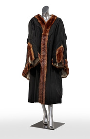
Ceremonial object - Robe, J. Ravensdale, Mayoral Robe
Full length black mayoral ceremonial robe with centre front opening. Dark brown ermine fur edging on centre front opening and cuffs. Decorative piping edging and white satin lining in sleeves. Gathered/puckered detail at back. mayoral robe, robe, ceremonial wear, mayor, bayside, brighton, sandringham, j. ravensdale, mayoral regalia -
 Ballarat Tramway Museum
Slide - 35mm slide/s - set of 5, Roy J Mitchell, late 1960's
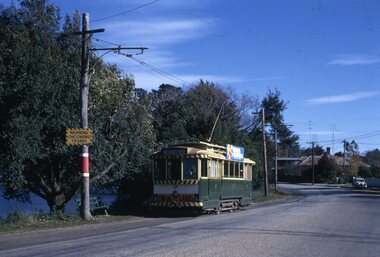
Set of four green Fuji Film green plastic slides during late 1960's of: 1 - tram No. 11 southbound in Lydiard St North, at the level crossing with destination of Sebastopol. Has Osborne House in the background. .2 - ditto with tram 39 showing special .3 - Bogie tram crossing No. 11 (showing City) at Gregory St. No. 11 has a Twin Lakes sign .4 - Part of one of the timetable board as the City terminus, Sturt and Lydiard Sts. .5 - No. 17 with driver/conductor reversing the pole. Has the city in the far distance, looking back towards the city.On each slide in ink "Roy Mitchell" , "Tram" "1958-1971". .1 - "20" .2 - "28" .4 - "15"tramways, trams, lydiard st north, level crossings, gregory st, timetable boards, tram 11, tram 39, tram 17 -
 Queenscliffe Maritime Museum
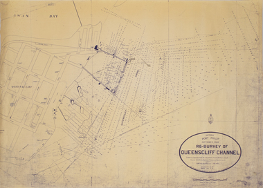
Map - Survey Chart, J. P. Larkin, Re-Survey of Queenscliff Channel, 29 October 1928
A paper chart showing sounding around the Queenscliff Channel dated 1928Victoria Port Phillip October 1928, Re survey of Queenscliff Channelqueenscliff channel, surveying, navigation -
 Ballarat Tramway Museum
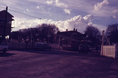
Photograph - Set of 8 colour 35mm slides of Ballarat Trams May 1971, Noel J Simons, 24/5/1971
Shows a sample of photographs taken about 3 months before the Ballarat Tramway system commenced to close.Yields information about various Ballarat Trams and the streetscape at the time prior to closure in August and September 1971Set of 8 Kodachrome transparencies taken on 24/5/1971 1172.1 - Tram 27 in Wendouree Parade, near Barrett Ave., with destination of Victoria St., passing a tram stop, with a seat and "Warning Oncoming Trams" sign mounted on the pole. Tram has a Twin Lakes advertisement on the front dash and a unknown roof advertisement. See also Reg. Item No. 1174.3 for a later photograph. 1172.2 - No. 32 entering Bridge St. from Sturt St. Photo taken after tram has passed photographer. Has Woolworths and Dickins stores in the background, and many motor vehicles. Tram has destination of Mt Pleasant 1172.3 - No. 13 in bound along Sturt St. West, near Alfred St. looking west along Sturt St. West. Has destination of Mt. Pleasant. 1172.4 - as for 1172.3, but closer up. 1172.5 - No. 17 west bound along Sturt St. passing the Town Hall, with Myers and Queen Victoria's statue in the background. Taken from the north side of Sturt St. through the median strip. 1172.6 - No. 13 at the City terminus, on the south side of Sturt St. with the National Mutual and other buildings up to the Town Hall in the background, including the fountain and the city terminus shelter. 1172.7 - Bogie tram at the city terminus, on the south side of Sturt St. looking from the central median strip, westwards. Has Town Hall in background along with other buildings. 1172. 8 - as above but with Scrubber car behind a bogie tram. Shows fountain and ESCo control box by a pole.wendouree parade, •tram stops, •bridge st, •sturt st. west, •murray st., •sturt st, •town hall, •scrubber tram, tram 27, tram 32, tran 13, tram 17, ballarat, tramways, trams -
 Ballarat Tramway Museum
Document - Manuscript, Peter J Barry, "Signalling and Operations on the Tramway System in Bendigo", April 1990
Draft of an article with notes/additions by Keith Kiings on the signalling system and tramcar operations in Bendigo. Looks at the basic services, crossing loops, signalling, following movements (Bendigo used a white disc on the tram to indicate a following tram, Ballarat did not use this system), short workings, reversals, observations of actual workings. Includes a map drawn by Keith Kings in 1972. Published in the September 1990 issue of Somersault, by the Signalling Record Society of Victoria.Yields information about the operation of the Bendigo tramway system using the Forest City Signalling system.Six A4 pages of a draft of an article by Peter Barry and correspondence to Keith Kings re "Signalling and Operations on the Tramway System in Bendigo, April 1990.tramways, trams, bendigo, signalling, forest city, operations, crossing loops, srsv -
Moorabbin Air Museum
Booklet - MODERN CIVIL AIRCRAFT:9, IAN ALLAN LTD, 1991
-
Moorabbin Air Museum
Book - History of Bell Aircraft models Bell Aircraft since 1935, Bell Aircraft since 1935
History of Bell Aircraft since 1935half inch think, silver jacket, X-1 Glamorous Glennis on jacketnon-fictionHistory of Bell Aircraft since 1935 -
Moorabbin Air Museum
Book - Production history and some photos of McDonnell Douglas Aircraft since 1920, McDonnell Douglas Aircraft since 1920, 1979
Red jacket with photo of DC-7non-fiction -
Moorabbin Air Museum
Book - Very detailed history and photos of The Lockheed Constellation Series, The Lockheed Constellation Series, 1982
Very detailed history and photos of The Lockheed Constellation Series: The Lockheed Constellation SeriesJacket showing Silver Constellation in flight, cloud in backgroundnon-fictionVery detailed history and photos of The Lockheed Constellation Series: The Lockheed Constellation Series -
Moorabbin Air Museum
Book - Description of and listing of international users of the British Aerospace 748, British Aerospace 748, 1986
Description of and listing of international users of the British Aerospace 748Cover showing British Aerospace 748 over estuarynon-fictionDescription of and listing of international users of the British Aerospace 748 -
Moorabbin Air Museum
Magazine - THE RAF PLANES OF WORLD WAR 2, PHILIP J R MOYES, 1981
-
Moorabbin Air Museum
Book - History of development of Learjets, LEARJETS The World's Executive Aircraft, LEARJETS The World's Executive Aircraft, 1990
History of development of Learjets, LEARJETS The World's Executive AircraftFront cover showing close up photo of Learjet in flight, blue skynon-fictionHistory of development of Learjets, LEARJETS The World's Executive Aircraft -
 Buninyong & District Historical Society
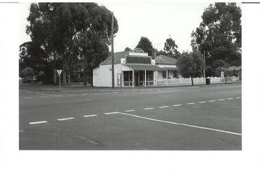
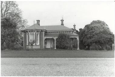
Photograph - B/W photograph, Mr. C. J. Brooks, Former Middleton's Hardware Shop Warrenheip Street Buninyong, 19 April 1994
1994 photograph of early well known Hardware shop (built 1906) operated by the Middleton family.Example of an early weatherboard shop and residence operated by a local familyBlack and white photograph of former weatherboard Middleton's Hardware Store on the West Side of Warrenheip Street North. Adjacent residential house clearly visible.middleton family, hardware shop, local business, weatherboard, building, streetscape, warrenheip street -
 Buninyong & District Historical Society
Photograph - B/W photograph, Mr. C. J. Brooks, Former Middleton's Hardware Shop Warrenheip Street Buninyong and residence, 19th April 1994
1994 photograph of early well known Hardware shop and residence associated with the Middleton family.Example of an early weatherboard shop and residence operated by a local familyBlack and white photograph of streetscape, West side of Warrenheip Street North showing weatherboard residence and hardware shop associated with the Middleton familymiddleton family, warrenheip street, hardware shop, building, streetscape, ironmongery, weatherboard, local business -
 Buninyong & District Historical Society
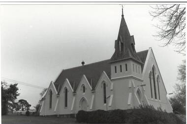
Photograph - B/W photograph, Mr. C J Brooks, Buninyong Uniting Church (formerly Presbyterian) side view, July 1993
Built in 1860 by Richard Rennie as Presbyterian ChurchRichard Rennie building, unusual designB/W photo of Uniting Church looking uphill from eastern side, showing gables and buttresses, belltower and steeple. Formerly Presbyterian Churchbuninyong, presbyterian, uniting, church, building, learmonth st -
 Buninyong & District Historical Society
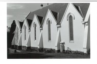
Photograph - B/W photograph, Mr C J Brooks, Buninyong Uniting Church (formerly Presbyterian) side view, close-up, Sept. 1993
Builder Richard Rennie, completed 1860 as Presbyterian ChurchHistoric building, Richard Rennie unique designB/W photoBuninyong Uniting Church (formerly Presbyterian) side view, close-upbuninyong, presbyterian, uniting, church, learmonth st, richard rennie -
 Buninyong & District Historical Society
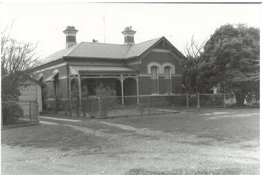
Photograph - B/W photograph, Mr C J Brooks, Former Police Station and residence, Scott St. Buninyong, July 1993
Historic public building, built by Richard Rennie, prominent local builderHistoric BuildingB/W Photo of former Police Station and Residence, built by Richard Rennie c1880, brick building, L-fronted, verandah, rendered cornice and window cappings.buninyong, police station, richard rennie, streetscape, scott st -
 Buninyong & District Historical Society
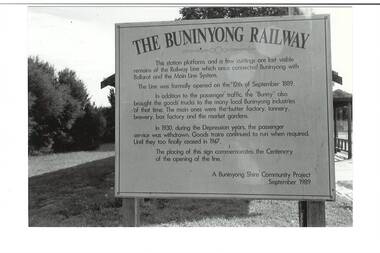
Photograph - B/W photograph, Mr C J Brooks, Buninyong Railway Station platform, (built 1889), 9 April 1994
Remains of Buninyong Railway Station platform, line closed 1947Only remains of Railway stationB/W photo remains Buninyong Railway Station platform, (built 1889) sign on left, power pole and Tennis Club shed, elm tree behind right.buninyong, bunny, railway, platform -
 Buninyong & District Historical Society
Photograph - B/W photograph, Mr C J Brooks, Buninyong Railway Station platform, (built 1889), 9 April 1994
Remains of Buninyong Railway Station platform, line closed 1947Only remains of Railway stationB/W photo remains Buninyong Railway Station platform, (built 1889) Looking towards Forest Street down former railway track, platform on right, tennis club building, elm tree, tennis court fence on leftbuninyong, bunny, railway, platform -
 Buninyong & District Historical Society
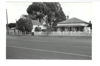
Photograph - B/W photograph, Mr C J Brooks, Former Presbyterian Manse, Buninyong, 19 July 1994
Built for Rev. Thomas Hastie, C19thFormer Presbyterian Manse, Scott St Buninyong, built for Rev. Thomas Hastie. Brick construction, bay window, polychrome, 3 chimneys, ornate wrought iron verandah.buninyong, presbyterian, manse, brick building -
 Buninyong & District Historical Society
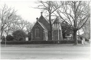
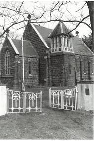
Photograph - B/W photograph, Mr C J Brooks, Holy Trinity Church of England, cnr Scott & Warrenheip Sts. Buninyong, July 1993
Original brick church/school (1857) and bluestone church (1862)BW photograph, of Holy Trinity Church of England church, corner of Scott Street and Warrenheip Street, Buninyong. Rev. Garrett John Russell arrived Buninyong 1857 when vicarage and school were built, Church of Holy Trinity opened in 1862.anglican, buninyong, church of england, bluestone, building -
 Buninyong & District Historical Society
Photograph - B/W photograph, Mr C J Brooks, Holy Trinity Church of England, cnr Scott & Warrenheip Sts. Buninyong, July 1993
Original brick church/school (1857) and bluestone church (1862)BW photograph, of Holy Trinity Church of England church, corner of Scott Street and Warrenheip Street, Buninyong. Rev. Garrett John Russell arrived Buninyong 1857 when vicarage and school were built, Church of Holy Trinity opened in 1862. 3/4 angle view through corner gates.anglican, buninyong, church of england, bluestone, building -
 Buninyong & District Historical Society
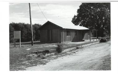
Photograph - B/W photograph, Mr C J Brooks, Hoarding for centenary of Buninyong Railway, 1994
Marks location of Buninyong Railway Station, demolished, only platform remains.Hoarding for centenary of Buninyong Library, erected by Buninyong Shire Council. Line opened 10 Sept. 1889. A Buninyong Shire Community Project 1989.buninyong, railway, station, sisgn, shire council -
 Buninyong & District Historical Society
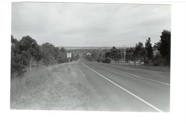
Photograph - B/W photograph, Mr. Clive J. Brooks, Eastern approach to Buninyong Midland Highway 1994, April 1994
Approach to township of Buninyong prior to amalgamation with Ballarat City Council. Buninyong shire town sign visible in foreground.Record of Buninyong Shire prior to amalgamationBlack and white photograph of the Eastern approach to Buninyong from the Midland Highway taken from opposite Ballantrae looking West. In left foreground is an example of Buninyong shire town sign before amalgamation 1994.buninyong shire, midland highway, street scene -
 Buninyong & District Historical Society
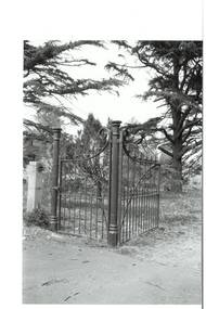
Photograph - Original B/W Photograph, Mr Clive J Brooks, Buninyong Cemetery gates, 9/4/1994
Cast iron gates commissioned from foundry at Castlemaine, for entrance to Buninyong Cemetery, Midland Highway. One pedestrian gate, one double gate. Gates acquired 1894. Originally olive green, gold-tipped spears. Painted white 1930s - 1940s. Damaged c1985, repaired by Mr Ron Nicholls, Buninyong. Repainted olive green 1992.Historically significant original gates acquired 1894.Buninyong Cemetery cast iron gatesbuninyong cemetery, gates, cast iron -
 Buninyong & District Historical Society
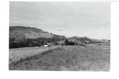
Photograph - B/W photograph, Mr. Clive J. Brooks, North Eastern slopes of Mount Buninyong from Yendon Road, April 1994
Tree cover on Mount Buninyong and agricultural use of land in 1994 clearly visible.Natural and agricultural record of Mount Buninyong in late 20th centuryBlack and white photograph of the North Eastern slopes of Mount Buninyong from Yendon No. 1 Road. Tree cover and agriculture use clearly visible.mount buninyong, landscape -
 Kew Historical Society Inc
Plan - Subdivision Plan, H C Crouch, Old Golf Links Estate, 1930s
The land in North Kew between the Outer Circle Railway and the River Yarra was released in sections. This release included 80 lots. Most of this area was released during the Depression years in the early 1930s.Subdivision plans are historically important documents used as evidence of the growth of suburbs in Australia. They frequently provide information about when the land was sold on which a built structure was subsequently constructed as well as evidence relating to surveyors and real estate and financial agents. The numerous subdivision plans in the Kew Historical Society's collection represent working documents, ranging from the initial sketches made in planning a subdivision to printed plans on which auctioneers or agents listed the prices for which individual lots were sold. In a number of cases, the reverse of a subdivision plan in the collection includes a photograph of a house that was also for sale by the agent. These photographs provide significant heritage information relating house design and decoration, fencing and household gardens.One part of a massive subdivision of the Old Golf Links Estate in North Kew of 80 allotments bordering Sutherland Avenue, Ramsay Avenue, Belford Road, Beresford Street and Coleman Avenue. Inset on the plan at the top left, the route of the Outer Circle Railway is clearly marked. The Kew Golf Links is identified in its current location. The land on which Greenacres Golf Club was to be constructed is at this time marked as ‘Recreation Ground’. The ‘new bridge’ over the Yarra at Burke Road is also marked on the inset map. The Plan identifies the surveyor (sic) H.C. Crouch BCE MVIS, 443 Little Collins St., Melbourne. The date of the subdivision auction sale in identified as Saturday September 25th at three o'clock.Annotations: "E" top left. "Golf Links" top right. Lots 73-76 ticked and listed as "6" poundssubdivisions -- kew (vic.), old golf links estate