Showing 10480 items
matching lander
-
 Greensborough Historical Society
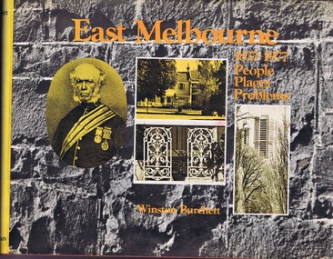
Book, Craftsmen Press, East Melbourne: 1837-1977: people, places, problems, 1977
A history of early development and more recent redevelopment in East Melbourne, from a town planning perspective.177 p., illus., maps.non-fictionA history of early development and more recent redevelopment in East Melbourne, from a town planning perspective.east melbourne, town planning, melbourne -
 Greensborough Historical Society
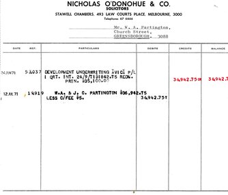
Legal record - Account, Nicholas O'Donohue & Co, Nicholas O'Donohue & Co to Partington 1971, 12/07/1971
A solicitor's account to Alan Partington following a land transaction with Development Underwriting Vic. P/L in 1971. Part of many land deals made by the Partington family in the sale of the original Greensborough farmland.Solicitor's account, black text on white paperalan partington, william alan partington, partington family, land deals greensborough, nullarbor -
 City of Moorabbin Historical Society (Operating the Box Cottage Museum)
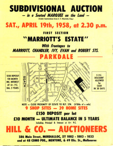
Flyer - Marriott's Estate, Parkdale, 1958
After WWII there was a decline in the market gardens in the City of Moorabbin, as the value of the land was more profitable than the crops.Example of the progress of the Municipality of MoorabbinPhotocopy of advertising flyer for auction of real estate sales - plan of building blocks for saleMarriott's Estate, Parkdale - Auction 19 April 1958 - 39 home sites - 9 shop sitesmarriott street, chandler st, ivy st, robert st, parkdale, real estate, auction -
 City of Moorabbin Historical Society (Operating the Box Cottage Museum)
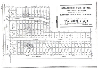
Flyer - Strathmore Park Estate, Jasper Road McKinnon, 1942
After WWII there was a decline in the market gardens in the City of Moorabbin, as the value of the land was more profitable than the crops.Example of the progress of the Municipality of MoorabbinPhotocopy of advertising flyer for auction of real estate sales - plan of building blocks for saleStrathmore Park Estate, Jasper Road Bentleigh Subdivided into 98 Ideal Allotmentsstrathmore street, wavell street, lindsay street, jasper road, mckinnon, bentleigh, real estate, auction -
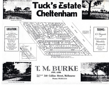 City of Moorabbin Historical Society (Operating the Box Cottage Museum)
Flyer - Tuck's Estate, Cheltenham, 1940
After WWII there was a decline in the market gardens in the City of Moorabbin, as the value of the land was more profitable than the crops.Example of the progress of the Municipality of MoorabbinPhotocopy of advertising flyer for sale of real estate sales - plan of building blocks for saleTuck's Estate Cheltenham - plan of subdivisionedward street, point nepean road, eden street, tuck street, hoffman street, elman road, page street, cheltenham, real estates, auction, tuck -
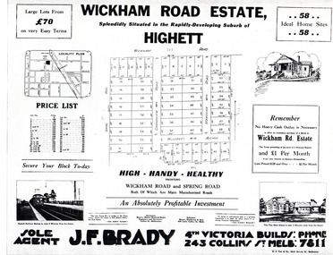 City of Moorabbin Historical Society (Operating the Box Cottage Museum)
Flyer - Wickham Road Estate, Highett, 1940
After WWII there was a decline in the market gardens in the City of Moorabbin, as the value of the land was more profitable than the crops.Example of the progress of the Municipality of MoorabbinAdvertising flyer for auction of real estate sales - plan of building blocks for saleWickham Road Estate, Highett 58 Home siteshillcrest ave, wickham road, spring road, grandview road, maroona road, highett, land sales, real estate -
 Port Melbourne Historical & Preservation Society
Document - purchase and building costs SSB, Public Records Office Victoria (PROV), 1886 - 1982
The State Savings Bank building was constructed c1891. This note outlines land purchase costa and building costsCOPYRIGHT Public records Office Victoria .03 - 1886 document built environment - commercial, business and traders, state savings bank of victoria -
 Ballarat Heritage Services
Map, Plancius's Map (Amsterdam), 1594
Copy of a Dutch map published in Amsterdam. showing a large stretch of outhern land called Terra sustralis Copy of a map from 'A Short HIstory of Australia' by Ernest Scott.map, plascius, placius's map, terra australis, dutch map -
 Ballarat Heritage Services
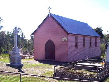
Photograph - Photograph - Colour, Clare Gervasoni, St Francis Xavier Chapel, Eganstown, 1999, 28/09/1999
The St Francis Xavier Chapel and Catholic Cemetery was established on land donated vby squatter John Egan.Three photographs of St Francis Xavier Chapel, the chapel in the Eganstown Catholic Cemetery. The grave stone at the front of the church is for John Egan. st francis xavier chapel, eganstown, 1999, eganstown catholic cemetery, eganstown, church, chapel, cemetery, john egan -
 Lakes Entrance Regional Historical Society (operating as Lakes Entrance History Centre & Museum)
Postcard, 1955c
Kalimna Hotel built 1884 to 1885 by Thomas Laughton on land previously leased by Peter Egan FishermanTinted postcard of Kalimna Hotel showing a Pioneer Tourist Coach parked at the front with glimpse of Beer Garden on Western side of main building, Hotel Road Kalimna Victoriabusinesses -
Whittlesea Historical Society Inc.
Document - Receipt, Yan Yean Public Cemetery, 1892
Yan Yean Public Cemetery receipt for Allotment of Land for the deceased Jas H. Lockwood. Dated 1892.A small paper receipt, 1 of 2 items pinned togetherSigned by James Ryan Jnr, Secretary.yan yean cemetery, james h lockwood -
 Sunbury Family History and Heritage Society Inc.
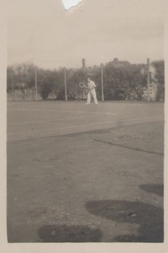
Photograph, c 1930s
The man was photographed playing tennis on the tennis courts that were sited on railway land in Evans Street Sunbury. A small snapshot of a man on a tennis court.tennis, tennis courts -
 Tarnagulla History Archive
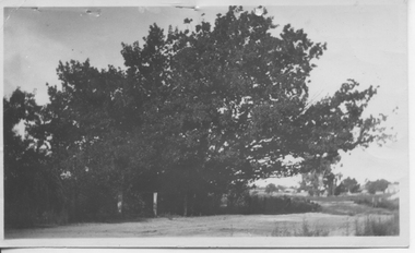
Photograph: Oak Tree, Llanelly, 1922
Not clear whether Annie Heffernan is the photographer or owner of the land where tree was situated. Donald Clark Collection. A monochrome photograph of a large oak tree in Llanelly, Victoria. Accompanied by a poem by John Hurford typed on a piece of paper. Title of poem is 'The Oak'. Dated 12/02/1922. The poem is catalogued separately.Written on reverse: 'Oak Tree Annie Heffernan Llanelly 1922'.llanelly, trees, tree -
 City of Kingston
Pamphlet - Black and white, J. F. Brady, The Hill Estate, Highett, c. 1905
Sales plan for land in the suburb of Highett, bounded by Sandford Street, Turner Street and Point Nepean RoadThe developing urban area of Highett within the City of Kingston. This land sale pamphlet illustrates the subdivision of land within the municipality and the changing demographic of the district as new houses are constructed close to infrastructure.Black and white pamphlet advertising for sale the Hill Estate, Highett. Incorporates a map of the estate bordered by Sandford Street, Turner Street and Point Nepean Road.Handwritten in grey pencil on reverse: The Hillland sales, highett, estate -
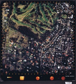
 Heidelberg Golf Club
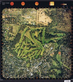
Photograph - Aerial Photograph, Heidelberg Golf Course 2000, 01/05/1980
Aerial photograph of Heidelberg Golf Club course in 1980, showing the course layout and surrounding land use.Aerial photograph, colour.Printed on edge of photo: "Colour proof", "LandSur756"aerial photographs, heidelberg golf club, lower plenty -
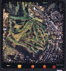
 Heidelberg Golf Club
Photograph - Aerial Photograph, Heidelberg Golf Course 2000, 01/05/1980
Aerial photograph of Heidelberg Golf Club course in 1980, showing layout of course and surrounding land use.Aerial photograph, colour.Printed on edge of photo: "Colour proof", "LandSur756"aerial photographs, heidelberg golf club, lower plenty -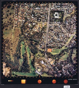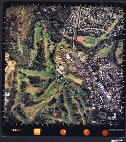
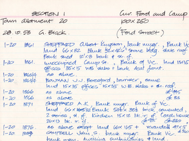 The Beechworth Burke Museum Research Collection
Card (Series) - Index Card, George Tibbits, Cnr Ford and Camp Streets (Ford St), Beechworth, 1976
George Tibbits, University of Melbourne. Faculty of Architecture, Building and Town & Regional PlanningIndex system that support the research for Beechworth : historical reconstruction / [by] George Tibbits ... [et al]Arranged by street names of BeechworthEach index card includes: street name and number of property, image of property, allotment and section number, property owners and dates of ownership, description of the property according to rate records, property floor plan with dimensions.beechworth, george tibbitsbeechworth, george tibbits -
 City of Moorabbin Historical Society (Operating the Box Cottage Museum)
Plan - Grandview Estate
The train line from the city to Frankston was electrified in 1922 which intensified the sale in the municipality of Moorabbin, particularly land which was in the vicinity of the railway stations.The train line from the city to Frankston was electrified in 1922 which intensified the sale in the municipality of Moorabbin, particularly land which was in the vicinity of the railway stations. The Grandview Estate was auctioned on Saturday 10 November 1922.Example of the progress of the Municipality of MoorabbinHand drawn map of subdivision Grandview Estate, Bentleighcentre road, evelyn street (now wilson street), lily street, bentleigh, realestate, auction -
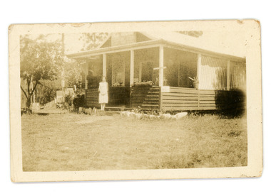 Mt Dandenong & District Historical Society Inc.
Photograph
Jim Keogh owned Lot 7 of the Village Settlement. When the new CRB road went through c1920 his block was cut through leaving a small triangle of land on the high side of the CRB road. He built a shop on this piece of land. The store burned down 31/12/1939. The woman on the step in this photo is Win Woodcock.Sepia image of a woman standing in front of a wooden store. Handwritten inscription on reverse by John Lundy-ClarkeJim Keogh's shop on the north west corner of Falls and Main Roads. Opposite diagonally from St Michael's Church of England. photo Nov 1926.jim keogh, keogh, store, shop, crb road, win woodcock -
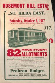 Melbourne Tram Museum
Ephemera - Real estate sale, Prahran Hodges, "Rosemont Hill Estate", Oct. 1917
Pamphlet advertising the sale of land at the "Rosemont Hill Estate", Balaclava Road, St Kilda East, 6-10-1917. On the front cover has a photo of PMTT tram No. 27. Gives terms of sale, the plan of the subdivision, and a general locality plan showing tram and rail lines. Land prices have been written in for some blocks on the pamphlet. Demonstrates the style of land sale pamphlet including the availability of tram services to prospective purchasers.Pamphlet - folded - printed in two colours of cream coloured paper with photographs and plans.has pencil notes re sale price and notes for some blocks.sale of land, trams, real estate, balaclava road, st kilda east, pmtt, tram 27, rosemont hill estate -
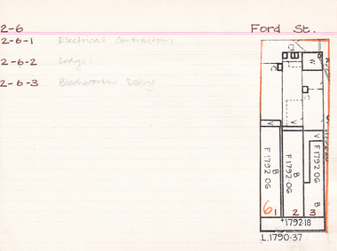 The Beechworth Burke Museum Research Collection
Card - Index Card, George Tibbits, Ford Street, Beechworth, 1976
Property - Ford Street, Beechworth - Section 2, Town Allotment 6 - (Note: also 2-6-1 Electrical Contractors, 2-6-2 Lodge and 2-6-3 Beechworth Dairy) - 100' x250' Ownership details and history - 28 Oct 1853 - W.H. Neuber 1861 - Galbraith, Andrew - Faulkner George, unlisted, J.S. Clark. land 22'x165', shop 32'x20' glass + deal fr. 2 stories, WB + sh. Bakery 25'x20' slabs + bark. Stable 20'x10' WB + do. 1861 - Steel, William, unlisted, J. Manson. land 11'x140' shop 10'x33' plate glass & cedar front, slabs + sh. Back 10'6"x34' WB + sh. 1861 - Joel, Abraham, unlisted, J. Manson, land 11'x140' shop 10'x33' plate glass + cedar front, slabs + sh. bark, 10'6"x34' WB + do. 1861 - J. Manson, unlisted, same, land 22'x25' (in rear) stable 14'x14' slabs + bark 1861 - George Gammon, unlisted, same, land 22'x165' shop 14'x31' glazed front. deal + WB slabs + sh. Kitchen 15'x12' store in rear 20'x10' do + bark 1863/4 - Eveleigh, J.L. (A. Galbraith in '63-'63) J.S. Clark land + prem as 1861. 1863/4 - Hall, Algernon, J. Manson. land + prem as 1861 1863/4 - Faulkner, baker & confectioner, J. Manson, land + prem as 1861 1863/4 - Manson, John as 1861 1863/4 - Gammon as 1861, Kitchen 15'x12' bk. resid. 24'x12' 1866 - Raphael, Julius, Tobias, Sally, tobacconists, J.S. Clark, land 22'x165 shop 20'x38' bk. bldg. glass fr. + sh. rf. Kitch. in rear 14'x12' WB = sh. Do. Stable 20'x10' slabs + bark. £115 1866 - Cunningham, James & Robert, ironmongers, John Manson, land 22'x165' shop 20'x33' plate glass + cedar fr. slabs + sh. rf. prem in rear 21'x34' WB + sh. rf. £110 1866 - Gammon, George, Druggist, same. land 22'x165' prem. 30'x20' + 24'x12' bk. bldg. 2 stories with plate glass + cedar shop front + sh. rf. Kitchen 15'x12' WB + sh. rf. 1871 - Brown, John, Barber etc. J.S. Clark. land + prem as 1866 £75 1871 - Cunningham, J&R, ironmongers, same. land + prem as 1866 + stable 13'x8' slabs + bark £96 1871 - Gammon, G. Druggist, same land + prem as 1866 £144 1876 - Walton, Wm. Tailor, Mary Clark. prem as 1866 exc. kitch 16'x12' + 20'x10' 1876 - Cunningham, J&R, ironmongers, same land 22'x165' prem 20'x30' deal fr. bk walls sh. roof Do. in rear 34'x21. WB + sh. rf. stable 20'x20' WB + ir. rf. £90 1876 - Gammon, George, Chemist, same land + prem as 1866 exc. no. 24'x12' bk £120 1884 - Armstrong, John, Draper, Mary Clark. shop 1884 - Cunningham Js. Ironmonger, same shop 1884 - Gammon, G. Chemist, same, shop + dwelling 1889 - Armstrong, as above £45 1889 - Cunningham, JS. as above. Cunningham, J&R, shop, prem + land £70 1889 - Gammon, G. Chemist, smae shop, dwelling pr. l. £80 1899-1900 - Armstrong. One shop owned, other ....? one 1900-1901 - Armstrong. double shop 1900 - Armstrong, John, draper, same shop + store £110 1900 - Bowen, Wm Johnston, Chemist, Kate Gammon, Sh. DW + L £65 1906 - Armstrong, Draper, same S+L £110 1906 - Bowen, Wm. Johnston, Chemist, Kate Gammon, shop, prem + land £65 Sect. 2, Town Allot. 6 - Note: 2-6-1 Electrical Contractors, 2-6-2 Lodge and 2-6-3 Beechworth Dairy Architectural Index Card - Brian Pump and Tony Dugan - Photographers beechworth, george tibbits -
 Ringwood and District Historical Society
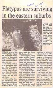
Newspaper, Scrapbook Clipping, Library Collection, Ringwood, Victoria
Newspaper Clipping from "The Post", 14 January 1997, Page 11, "Platypus are surviving in the eastern suburbs"'.A major survey of Melbourne's platypus population has found a "healthy number" of the animals living in creeks and rivers close to residential area in the outer east. Conservation and Land Management Minister, Marie Tehan, was present at the launching of the survey results, and spoke in detail about the results and the future planning and financial aid for the health of the Melbourne waterways. -
 Kew Historical Society Inc
Photograph - Willsmere [Kew] Billabong, 1993
Willsmere Park is bounded by the the Yarra River, Green Acres Golf Club, Willow Grove and the Eastern Freeway. The land on which the park is now situated was bought by Thomas Wills at the Crown Land Sales of 1846 (Section 56). From the 1840s to the 1940s it was intensively farmed. The park is dominated by very large playing fields, while planting to the southern boundary was undertaken when the Eastern Freeway was built. It is only along the banks of the Yarra that there is any remnant native vegetation. Willsmere Park is of significance as an area of open land that remains from the flood plain that once dominated northern Kew. (Source: Kew Conservation Study, 1988)Original colour small format polaroid photograph of the 'Kew Billabong' in the Willsmere Park, taken on 16 September 1993."Willsmere Billabong 16.9.93"kew billabong, willsmere park, yarra river -- billabongs -
 Kew Historical Society Inc
Photograph - Yarra River in flood at the Willsmere Park, 1993
Willsmere Park is bounded by the the Yarra River, Green Acres Golf Club, Willow Grove and the Eastern Freeway. The land on which the park is now situated was bought by Thomas Wills at the Crown Land Sales of 1846 (Section 56). From the 1840s to the 1940s it was intensively farmed. The park is dominated by very large playing fields, while planting to the southern boundary was undertaken when the Eastern Freeway was built. It is only along the banks of the Yarra that there is any remnant native vegetation. Willsmere Park is of significance as an area of open land that remains from the flood plain that once dominated northern Kew. (Source: Kew Conservation Study, 1988)Original colour small format polaroid photograph of the Yarra River in flood at the Willsmere Park, taken on 16 September 1993."Yarra River at Willsmere Park Flooding 16.9.93"willsmere park, yarra river -- floods -- kew (vic.) -
 Kew Historical Society Inc
Photograph - Flooding in the Willsmere Park, 1993
Willsmere Park is bounded by the the Yarra River, Green Acres Golf Club, Willow Grove and the Eastern Freeway. The land on which the park is now situated was bought by Thomas Wills at the Crown Land Sales of 1846 (Section 56). From the 1840s to the 1940s it was intensively farmed. The park is dominated by very large playing fields, while planting to the southern boundary was undertaken when the Eastern Freeway was built. It is only along the banks of the Yarra that there is any remnant native vegetation. Willsmere Park is of significance as an area of open land that remains from the flood plain that once dominated northern Kew. (Source: Kew Conservation Study, 1988)Original colour small format polaroid photograph of flooding in the Willsmere Park, taken on 16 September 1993."Flooding of shared path from Willsmere Billabong 16.9.93"willsmere park, yarra river -- floods -- kew (vic.), kew billabong -
 Kew Historical Society Inc
Photograph - Flooding in the Willsmere Park, 1993
Willsmere Park is bounded by the the Yarra River, Green Acres Golf Club, Willow Grove and the Eastern Freeway. The land on which the park is now situated was bought by Thomas Wills at the Crown Land Sales of 1846 (Section 56). From the 1840s to the 1940s it was intensively farmed. The park is dominated by very large playing fields, while planting to the southern boundary was undertaken when the Eastern Freeway was built. It is only along the banks of the Yarra that there is any remnant native vegetation. Willsmere Park is of significance as an area of open land that remains from the flood plain that once dominated northern Kew. (Source: Kew Conservation Study, 1988)Original colour small format polaroid photograph of flooding in the Willsmere Park, taken on 16 September 1993."Flooding of Willsmere Park from Yarra 16.9.93"willsmere park, yarra river -- floods -- kew (vic.) -
 Kew Historical Society Inc
Photograph - Flooding of Willsmere Park from Yarra, 1993
Willsmere Park is bounded by the the Yarra River, Green Acres Golf Club, Willow Grove and the Eastern Freeway. The land on which the park is now situated was bought by Thomas Wills at the Crown Land Sales of 1846 (Section 56). From the 1840s to the 1940s it was intensively farmed. The park is dominated by very large playing fields, while planting to the southern boundary was undertaken when the Eastern Freeway was built. It is only along the banks of the Yarra that there is any remnant native vegetation. Willsmere Park is of significance as an area of open land that remains from the flood plain that once dominated northern Kew. (Source: Kew Conservation Study, 1988)Original colour small format polaroid photograph of flooding in Willsmere Park resulting from heavy rain on 15 September 1993."Flooding of Willsmere Park from Yarra 16.9.93"yarra river -- floods -- kew (vic.), willsmere park