Showing 123958 items
matching main-road
-
 Eltham District Historical Society Inc
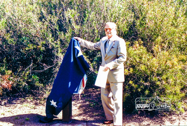
Photograph, Fitting of Time Capsule, Eltham, 1987, 1987
In November 1985 a monument was installed near the corner of Main Road and Pitt Street in Eltham, within the gardens at the front of what is now the Eltham Community and Reception Centre. This monument commemorates Victoria's 150th anniversary and the former location of the Eltham Town Centre, which existed along this section of Main Road, then known as Maria Street. Beneath the site is a time capsule to be opened in the year 2035. A plaque was also erected at this site in October 1987 to commemorate the Shire of Eltham Historical Society's 20th anniversary. The main feature of this monument is a ?tyring disc?, a blacksmith?s implement that was found on this site. This consists of a large iron disc that was used as a platform for fitting iron tyres (like the one shown on top of the platform) to wooden spoked cart wheels. The local blacksmith and wheelwright worked together to assemble the wheel, which was clamped to the platform placed close to the fire. The red hot iron hoop, previously forged to the correct size was lifted with tongs by the blacksmith over the outside of the rim, then hammered down amid flames from the scorching timber. The wheelwright drenched the tyre with cold water as soon as it was in position. A clamp placed on the naff (hub) and screwed down tightly kept the spokes at a constant angle as the tyre cooled. An even pressure from the contracting tyre tightened the joints at each end of the spokes and formed a vice-like grip, which would last for the life of the wheel.Colour photograph (one of four)eltham, joh ebeli, time capsule -
 Stawell Historical Society Inc
Photograph, Upper Main Street Stawell with the Patrick Street & Main Street corner at centre of Photo 1880
Stawell Township - Upper Main Street 1880. Patrick Street Main Street corner at centre of Photo.stawell -
 Eltham District Historical Society Inc
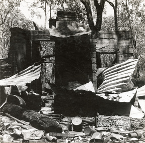
Photograph, George W. Bell, 'Windy' Gale's burnt out home, Wild Dog Creek Road, Jan. 1962, Jan 1962
Building of Pensioners Cottages at St Andrews; for those burnt out in the 1962 bushfires. A voluntary scheme of Mavis Gill through the Kangaroo Ground Relief CommitteeBlack and white photo mounted on card'Windy' Gale's burnt out home, Wild Dog Creek Road Photo Geo. W. Bell, Jan. 1962victorian bushfires - 1962, bushfires, dick (windy) gale, fire damage - buildings, george w bell, houses, st andrews, wild dog creek road, mavis gill, pensioners cottages -
 Ringwood and District Historical Society
Photograph, Maroondah Highway Central, Ringwood. Shops in Main Street, 1926
Black and white photograph (2 copies) Typed below photograph: "Maroondah Hwy. 1926. Shops now Safeway and Eastland carparks". Written on rear of backing sheet: "Main St. 1926". Image shows unmade street lined with shops from Warrandyte Road to Melbourne Street. -
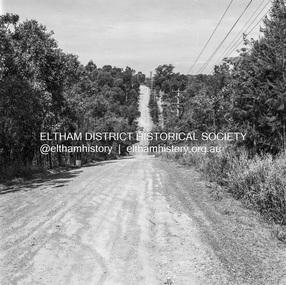
 Eltham District Historical Society Inc
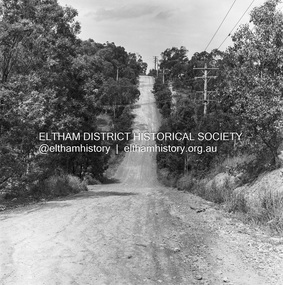
Photograph, Michael Wood, Progress Road looking east from Scenic Crescent, Eltham, 1976, 1976
Progress Road between Ryans Road and Lower Road, Eltham North; prior to realignment and construction, 1976Kodak Safety Film 120 format 6 x 6 cm black and white negative; 3 strips, 12 frames Also 30 x 25 cm black and white print of this image frameeltham north, scenic crescent, progress road, road construction -
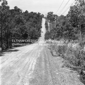
 Eltham District Historical Society Inc
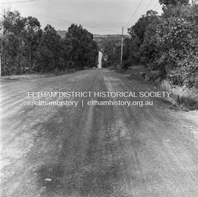
Photograph, Michael Wood, Progress Road looking east from outside No. 180, Eltham North, 1976, 1976
Progress Road between Ryans Road and Lower Road, Eltham North; prior to realignment and construction, 1976Kodak Safety Film 120 format 6 x 6 cm black and white negative; 3 strips, 12 frames Also 30 x 25 cm black and white print of this image frameeltham north, progress road, road construction -
 Eltham District Historical Society Inc
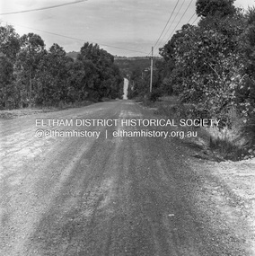
Photograph, Michael Wood, Progress Road looking east from outside No. 180, Eltham North, 1976, 1976
Progress Road between Ryans Road and Lower Road, Eltham North; prior to realignment and construction, 1976Kodak Safety Film 120 format 6 x 6 cm black and white negative; 3 strips, 12 frameseltham north, progress road, road construction -
 Eltham District Historical Society Inc
Photograph, Michael Wood, Progress Road looking east from outside No. 180, Eltham North, 1976, 1976
Progress Road between Ryans Road and Lower Road, Eltham North; prior to realignment and construction, 1976Kodak Safety Film 120 format 6 x 6 cm black and white negative; 3 strips, 12 frames Also 30 x 25 cm black and white print of this image frameeltham north, progress road, road construction -
 Eltham District Historical Society Inc
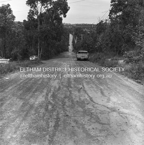
Photograph, Michael Wood, Progress Road looking east from near outside No. 196, Eltham North, 1976, 1976
Progress Road between Ryans Road and Lower Road, Eltham North; prior to realignment and construction, 1976Kodak Safety Film 120 format 6 x 6 cm black and white negative; 1 strips, 2 frameseltham north, progress road, road construction -
 Eltham District Historical Society Inc
Photograph, Michael Wood, Progress Road looking east from near outside No. 196, Eltham North, 1976, 1976
Progress Road between Ryans Road and Lower Road, Eltham North; prior to realignment and construction, 1976Kodak Safety Film 120 format 6 x 6 cm black and white negative; 1 strips, 2 frameseltham north, progress road, road construction -
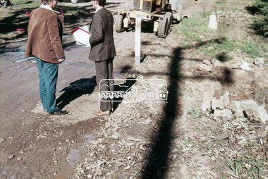 Eltham District Historical Society Inc
Slide, West side of Bonds Road at culvert end wall, Lower Plenty, 18 July 1972, 1972
Water drainage work undertaken by Eltham Shire Council in Bonds Road, Lower Plenty outside the Martin property opposite Montpelier Drive, July 1972 Pitchers in foreground were part of the end wall which was eroded out due to water crossing the road and not going through the culvert. 35 mm colour positive transparency Mount - Agfacolor Service (Blue)Bonds Road (Martin property) 12.10 pm 18.7.72bonds road, drainage works, eltham shire council, infrastructure, lower plenty, martin property, montpelier drive -
 Federation University Historical Collection
Plan - Main Street Plan, John Carruthers, Plan of Main Street Ballarat done by J Carruthers 1858, 1858
This is an Historical plan of Ballarat and gives us a look back in time.long thin hand drawn plan of Main Street Ballarat on brown wax paper.j carruthers, main st, main street, free trade hotel, eureka street, specimen hill road, humffray street, star hotel, old kaiser hotel, golden age hotel, royal mail hotel, john carruthers -
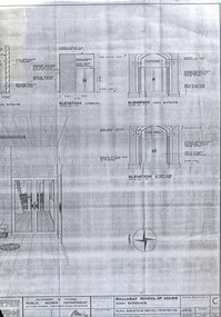 Federation University Historical Collection
Plan - Building Plan, School of Mines: Administration Building Main Entrance, 22/09/1964
Photocopy of a plan produced by the Government of Victoria for alterations to the Main Entrance to the SMB Administration Building.ballarat school of mines, administration building, main entrance, lydiard street, a building, new classroom -
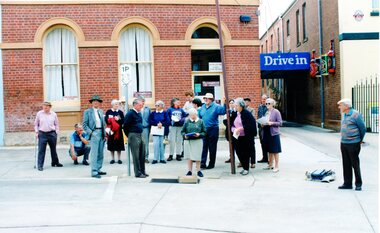 Stawell Historical Society Inc
Photograph, Gathering in Main Street
Colour Photograph: Group of people outside building in Main Street next to driveway of hotelDrive In ( Sign over roadway) Gertrude Edith Smith Licensed Second Hand Dealer (over doorway), various signs on door. sign on window to the right, next to Parking sign.main street -
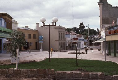 Stawell Historical Society Inc
Slide, Ian McCann, Upper Main Street looking to ward Big Hill from Victoria Street
Top of Mall / Main Street Looking toward Big Hill from Victoria Streetstawell main street streetscape, buildings -
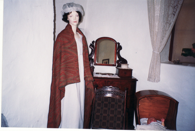 Whitehorse Historical Society Inc.
Photograph, Main Bedroom - Schwerkolt Cottage
Coloured photograph of main bedroom of Schwerkolt Cottage showing model in corner and part of cradle.schwerkolt cottage & museum complex, nunawading & district historical society -
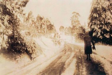 Mt Dandenong & District Historical Society Inc.
Photograph, Miss Perriman on Main Highway, Kalorama 1931, c1930
Back view of Miss Perriman walking along the Main Highway, Kalorama, in the snow in 1931.kalorama, snow, main highway, perriman -
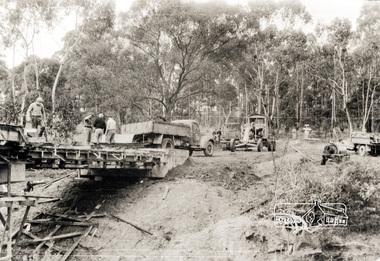 Eltham District Historical Society Inc
Photograph, Oxley Bridge construction, Henley Road, Kangaroo Ground, 1962, 1962
This is copy of a photograph taken 1962, during the construction of Oxley Bridge at Kangaroo GroundBlack and white photograph of Oxley Bridge construction over Watsons Creek, Henley Road, Kangaroo Ground, circa Aug-Sep 1962kangaroo ground, oxley bridge, watsons creek, henley road, bridges -
Whitehorse Historical Society Inc.
Newspaper - Article, 23 Boronia Road, Vermont, 1991
Newspaper article re 23 Boronia Road, Vermont. Auction. expected price: $500,000. c 1890 Home of Fay and Harry Williamsboronia road, vermont, no. 23, auctions., williams, fay, williams, harry -
 Whitehorse Historical Society Inc.
Photograph, Deep Creek Road, Mitcham, 1/09/2000 12:00:00 AM
Black and white photo looking North along Deep Creek Road, Mitcham, from Car Park at Schwerkolt Cottage Museum Complex.mitcham -
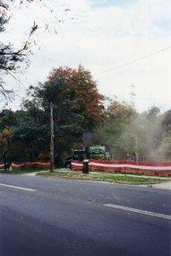 Whitehorse Historical Society Inc.
Photograph, Deep Creek Road, 1/04/2001 12:00:00 AM
Coloured photograph looking from Schwerkolt Cottage Reserve across Deep Creek Road as trees are cut down for construction of new Bridge.deep creek road, mitcham, vicroads -
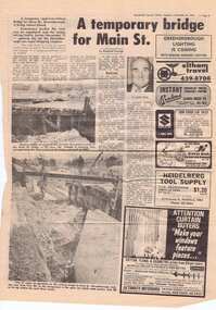 Greensborough Historical Society
Newspaper clipping, A temporary bridge for Main Street, 24/10/1978
Leading up to the opening of Greensborough Plaza, traffic along Main Street was affected by the part closure due to the construction of a road bridge over the railway line.Significant infrastructure changes in Greensborough at the time of the opening of Greensborough Plaza in 1978.Photocopy of news clipping (Item 958). Text and black and white images. -
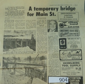 Greensborough Historical Society
Newspaper clipping, A temporary bridge for Main Street, 24/10/1978
Leading up to the opening of Greensborough Plaza, traffic along Main Street was affected by the part closure due to the construction of a road bridge over the railway line.Significant infrastructure changes in Greensborough at the time of the opening of Greensborough Plaza in 1978.Original news clipping (Item 904) and photocopy of same (Item 958). Text and black and white images.main street greensborough, para road, railway, greensborough plaza -
 Bacchus Marsh & District Historical Society
Photograph, Royal Hotel corner of Main and Young Streets Bacchus Marsh 1883
This image is one of a series of photographs taken by Melbourne based photographers Stevenson and McNicoll who visited Bacchus Marsh nearby districts between September and November 1883. The Royal Hotel was built in 1861 and is located on the corner of Main and Young Streets in Bacchus Marsh. The first owner was James Murray and the hotel was first known as the Murray Family Hotel. James Murray died in an accident in 1863 and sometime after this the ownership passed to Richard Manning. From around 1869 it became known as the Royal Hotel. Richard Manning's son Frederick Manning inherited the hotel in 1896. The Manning family owned the hotel until sometime after 1945. In more recent decades it has been owned and operated by a number of different people. The hotel continues to operate as of 2024. This image shows the building in its original structure. In 1888, five years after this image was taken, a second storey was added to the section on Young Street. In this image this section is the single storey section of wall without windows to the right of the picture. Small sepia 'carte de viste' style unframed photograph on card with gold border framing photograph. Housed in the album, 'Photographs of Bacchus Marsh and District in 1883 by Stevenson and McNicoll'. The image shows the Royal Hotel seen from the intersection of Main and Young Streets. The diagonal view shows both the Main Street and Young Street sides of the building. It is a two storey brick building with a single storey brick extension on the Young Street frontage. Standing at the corner of the building is a woman and five girls. A deep gutter runs along the Main Street, with a pedestrian crossing ramp. Over this crossing point, there is a large metal frame bearing an ornate lantern. Next to it is a water trough for horses. Several hitching posts can be seen along the footpaths.Printed On the front: Stevenson & McNicoll. Photo. 108 Elizabeth St. Melbourne. COPIES CAN BE OBTAINED AT ANY TIME. On the back: LIGHT & TRUTH inscribed on a banner surmounted by a representation of the rising sun. Copies of this Portrait can be had at any time by sending the Name and Post Office Money Order or Stamps for the amount of order to STEVENSON & McNICOLL LATE BENSON & STEVENSON, Photographers. 108 Elizabeth Street, MELBOURNE. stevenson and mcnicoll 1883 photographs of bacchus marsh and district, hotels bacchus marsh, royal hotel bacchus marsh, manning family bacchus marsh, murray family hotel bacchus marsh -
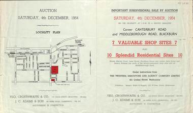 Whitehorse Historical Society Inc.
Pamphlet - Auction Flyer, Yeo, Crosthwaite & Co, Corner Canterbury Road and Middleborough Road, 4th December 1954
A green folded pamphlet advertising the sale of by auction of a shop and residential sites on the corner of Canterbury and Middleborough Roads, Blackburn on Saturday, 4 December 1954.A green folded pamphlet advertising the sale of by auction of a shop and residential sites on the corner of Canterbury and Middleborough Roads, Blackburn on Saturday, 4 December 1954.non-fictionA green folded pamphlet advertising the sale of by auction of a shop and residential sites on the corner of Canterbury and Middleborough Roads, Blackburn on Saturday, 4 December 1954.canterbury road blackburn, beck street, middleborough road blackburn, marion court, amery avenue, janet street, duckham street -
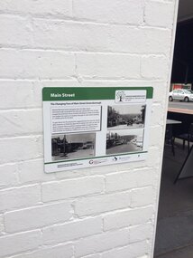 Greensborough Historical Society
Photograph - Digital Image, Chris Foster, The Changing face of Main Street Greensborough (Main Street Plaques Project), 17/05/2018
In 2018, Greensborough Historical Society placed plaques in the Main Street area of Greensborough. In these photographs, GHS member Chris Foster, accompanied by GHS President Noel Withers, has photographed the installation of the 'Changing face of Main Street' plaque on Main Street Greensborough. The Main Street Plaques Project placed historical information about original Greensborough buildings as close to the original site as possible. Further information available on the GHS website. The Plaques were made possible through a Greensborough RSL Grant.Digital copy of 3 colour photographs.main street plaques project, main street greensborough -
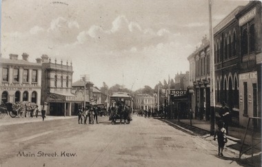 Kew Historical Society Inc
Postcard, Main Street, Kew, c.1890
The Kew Historical Society's Pictures Collection is comprised of photographs, postcards and original works of art. The postcards include original (mainly) images dating from the 1900s to the present. A number of postcards, some of which have numerous variants, were published as parts of series. Others are original images customised as postcards. Many of the postcards in the collection depict places within the suburbs of Kew and Kew East. Others depict locations in Victoria or internationally. A monochrome postcard showing Main Street [High Street], Kew, looking south west from near its junction with Cotham Road, showing: Ryan’s Council Family Hotel, T. G. Jellis (baker, confectioner), Herbert King (undertaker), L. Merritt (boot warehouse), horse tram, horse drawn vehicles and pedestrians.Post card text addressed to Miss Newell of Balmain.high street - kew, cotham road - kew, tramways - kew -
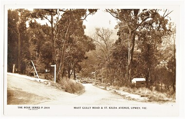 Sherbrooke Foothills Historical Society
Postcard - The Rose Series P.2910 Mast Gully Road & St.Kilda Avenue, Upwey, Vic. (identification item name), The Rose Series P.2910 Mast Gully Road & St.Kilda Avenue, Upwey, Vic. (identification title)
Rare view of mast Gully rd with sign post for St.Kilda Avenue ( contextual or historic information)Digital copy of original postcard published on ebay. The Rose Series P.2910 Mast Gully Road & St.Kilda Avenue, Upwey, Vic.( inscription) The Rose Series P.2910 Mast Gully Road & St.Kilda Avenue, Upwey, Vic.mast gully rd, st kilda ave, roads, upwey, signpost, rose series, subjects in context -
 Bacchus Marsh & District Historical Society
Photograph, Court House Main Street Bacchus Marsh 1883
The Court House in Main Street Bacchus Marsh was built in 1858 using local sandstone. It opened in 1859. It has been used for jury trials, a Court of Petty Sessions, a County Court and a Crown Land sales office. Other uses included an office for the Registrar of Births and Deaths, a Dairy Inspectors office from 1863-1865, and as meeting rooms for the Bacchus Marsh Roads Board, a forerunner of the Shire Council. It was also used by the Bacchus Marsh Shire Council for its offices until at least 1884. In more recent years it has functioned as a Magistrates Court with weekly court sessions. Small sepia unframed photograph on card with gold border framing photograph. Housed in the album, 'Photographs of Bacchus Marsh and District in 1883 by Stevenson and McNicoll'. The view of the Court House building is seen from the northern side of Main Street looking south or south-east. Three men are standing in the street in front of the building. The men on the left and the right wearing police helmets appear to be police officers. The man in the middle is in civilian clothes and might be an officer or employee of the Court House. He has his dog with him. A white picket fence runs along the front of the building. The front courtyard of the building has been renovated since, but this building still operates as a court house.On the front: Stevenson & McNicoll. Photo. 108 Elizabeth St. Melbourne. COPIES CAN BE OBTAINED AT ANY TIME. On the back: LIGHT & TRUTH inscribed on a banner surmounted by a representation of the rising sun. Copies of this Portrait can be had at any time by sending the Name and Post Office Money Order or Stamps for the amount of order to STEVENSON & McNICOLL LATE BENSON & STEVENSON, Photographers. 108 Elizabeth Street, MELBOURNE. stevenson and mcnicoll 1883 photographs of bacchus marsh and district, courthouses, bacchus marsh court house -
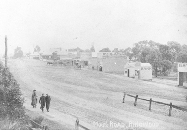 Ringwood and District Historical Society
Photograph, Maroondah Highway Central, Ringwood. Looking west from Warrandyte Road, 1910
Black and white photograph (2 copies)Written on rear of backing sheet of one photograph: "Main Road, Ringwood, looking west, Warrandyte Road coming in from right.". Image of central Ringwood including the E.S.& A. bank, Ringwood's first bank, 1910.