Showing 176503 items
matching streets
-
 Kew Historical Society Inc
Plan, Melbourne & Metropolitan Board of Works : Borough of Kew : Detail Plan No.1585, 1904
The Melbourne and Metropolitan Board of Works (MMBW) plans were produced from the 1890s to the 1950s. They were crucial to the design and development of Melbourne's sewerage and drainage system. The plans, at a scale of 40 feet to 1 inch (1:480), provide a detailed historical record of Melbourne streetscapes and environmental features. Each plan covers one or two street blocks (roughly six streets), showing details of buildings, including garden layouts and ownership boundaries, and features such as laneways, drains, bridges, parks, municipal boundaries and other prominent landmarks as they existed at the time each plan was produced. (Source: State Library of Victoria)This plan forms part of a large group of MMBW plans and maps that was donated to the Society by the Mr Poulter, City Engineer of the City of Kew in 1989. Within this collection, thirty-five hand-coloured plans, backed with linen, are of statewide significance as they include annotations that provide details of construction materials used in buildings in the first decade of the 20th century as well as additional information about land ownership and usage. The copies in the Public Record Office Victoria and the State Library of Victoria are monochrome versions which do not denote building materials so that the maps in this collection are invaluable and unique tools for researchers and heritage consultants. A number of the plans are not held in the collection of the State Library of Victoria so they have the additional attribute of rarity.Original survey plan, issued by the MMBW to a contractor with responsibility for constructing sewers in the area identified on the plan within the Borough of Kew. The plan was at some stage hand-coloured, possibly by the contractor, but more likely by officers working in the Engineering Department of the Borough and later Town, then City of Kew. The hand-coloured sections of buildings on the plan were used to denote masonry or brick constructions (pink), weatherboard constructions (yellow), and public buildings (grey). This plan, which covers parts of High Street, Pakington Street and Derby Street is dominated by two historic Kew mansions: ‘Konetta’ and ‘Ramornie’. Ramornie was constructed in 1890 for James Maitland Campbell, three times Mayor of Kew. Sold in 1940, it became a boarding house known as ‘The Towers’. Now a private residence again, it has only one of its three balconies remaining. The location of the missing two balconies can be seen on the plan. In 1903, the grounds of Ramornie included a large tennis court fronting Pakington Street. The rear of the property is shown as extending to Cobden Street. One of Kew’s oldest hotels, the Prospect Hill Hotel on the corner of High and Cobden Street was established in 1858. The outline of the hotel shown on the plan represents the second building on the site. During the 19th century it was often used for electoral meetings. The Prospect Hill Hotel was to be redeveloped again in 1928, by the local architect Robert McIntyre. Since the 1980s, the hotel has been a live music venue, the home of the Melbourne Jazz Club, a restaurant and a liquor outlet.melbourne and metropolitan board of works, detail plans, maps - borough of kew, mmbw 1585, cartography -
 Greensborough Historical Society
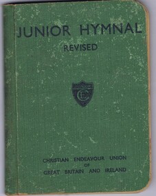
Book, Christian Endeavor Union of Great Britain and Ireland, Junior Hymnal revised, 1935c
Junior Hymnal from the Christian Endeavour Union of Great Britain and Ireland.Hardback, 107 p."Shirley Black, Grimshaw Street Bundoora"shirley black, hymnals -
 Ringwood and District Historical Society
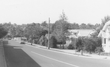
Photograph, Adelaide St, Ringwood (undated)
Written on back of photograph, "Adelaide Street". -
 Learmonth and District Historical Society Inc.
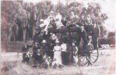
Photo, Ercildoune, family picnic, Circa 1900
This is the only known photo of a stage coach in the Learmonth and District Historical Societies collection. This is a copy of an original photo given to the society by Anne Beggs-Sunter. It also shows 33 adults and children whom are all dressed in their Sunday best clothes. It could have been a Christmas picnic.A rare photo of a stage coach held within the Learmonth and District Historical Society's collection.33 adults and children on, and around a stage coach at possibly Ercildoune, circa 1900. The photo is 21 & 1/2 cms wide x 12 & 1/2 high. It is a sepia photo.Richards & Co. Sturt Street. Ballarat. -
 Bendigo Historical Society Inc.
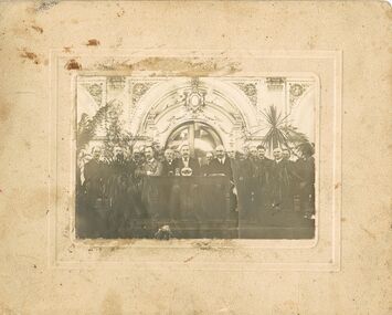
Photograph - JOSEPH DAVIES COLLECTION: PHOTOGRAPH OF 14 MEN, 1900's
Sepia? Photograph of 14 men. Three are seated at a small table and the rest are seated in a row behind them. There is a decorative wall and doorway behind them and some palms and other foliage in the photo. Photo is mounted on cream card with two indented borders. Handwritten on the back: Master H? Davies, Clive St., W. Footscray. Photographer's name is stamped on the back in blue.Cyril White, Mundy Street, Bendigophoto, group, male, joseph davies collection, photograph of 14 men, master h davies, cyril white -
 Bendigo Historical Society Inc.
Photograph - PORTRAIT OF A GIRL
Small half length portrait of a girl wearing a high neck dress with buttons to the waist and a frill collar. She has a shawl with fringes over her shoulders and is also wearing a hat.?, 7 Collins Street East, Melbournephotograph, portrait, girl, portrait of a girl -
 Bendigo Historical Society Inc.
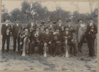
Photograph - STRATHFIELDSAYE SHIRE BAND, early 1900's
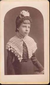
sepia photograph of the Strathfieldsaye Shire Band, showing thireen players and one leader. Many have ribboned hat bands, watch chains, Alberts, visible on left and right outer and centre members. All are suited and wearing hats. . Two wagons visible behind picket fence in background. Five members in front row are seated. On back in pencil ' from Mrs. Lowndes, McIvor Road. Back row Morgan Mulcare 1886, Harry Weiness, Joe Lewis, Jack Gladen 1870, Maurice Lewis 1884, Jim Griffin 1873/77/78 Jack Weiness, Ben Griffen, Frank McLean, Sitting : William Somerville 1858/79/82/85 Unknown, Thomas Somerville 1882/83 , Harry Manser 1885, Michael Sullivan 1867/68 MORE INFORMATION ON SHEETS BEHIND PHOTOR. Dermer Smith, Bull Street.organization, club/society, strathfieldsaye shire band -
 Bendigo Historical Society Inc.
Photograph - UNKNOWN FAMILY COLLECTION: PHOTOGRAPH
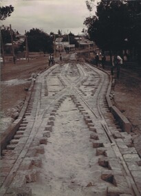
Photograph - black and white. Tram tracks being laid. Also bluestone blocks are used. On back on photo is the word 'Long Gully ?'. Park on left of photo then a building in middle of photo says 'A.Cornwell, Baker'.W.H. Robinson, Mundy Street, Bendigo.place, transport, tram, tram tracks. long gully. -
 Bendigo Historical Society Inc.
Photograph - UNKNOWN FAMILY COLLECTION: PHOTOGRAPH
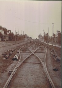
Photograph - black and white. Tram tracks being laid, could be Eaglehawk Road. Shop on left says ANDERSON CASH STORE. Written on back, Peter Brisbane, Room 4, 18 Churchill Avenue, Bendigo.W.H. Robinson, Mundy Street, Bendigo.place, transport, tram, tram track being laid. anderson cash store. -
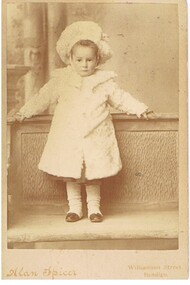 Bendigo Historical Society Inc.
Photograph - GILBERT RULE COLLECTION: PHOTO OF GLADYS RULE, 1903 ?
Gilbert Rule Collection: sepia toned photo of infant child, wearing a fur like coat, with long white spats over black shoes. Hat is matching coat.Alan Spicer, Williamson Street, Bendigoperson, individual, gilbert rule -
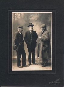 Bendigo Historical Society Inc.
Photograph - MURRAY, MR R.A.F, GOVERNMENT GEOLOGIST OF VICTORIA CIRCA 1900
Copy of black and white photo. Image shows three men posed talking. Man on left wearing a peaked fabric cap, pipe in mouth, three piece suit, fob chain visible. R. Murray in centre of photo, wearing three piece suit and hat Man on RH side, coat, fabric cap and holding pipe. On bottom of surround 'W. Vincent Kelly, Mitchell St. Bendigo' written in white script. Australian dictionary of biography entry re Murray enclosed with the photo.Vincent Kelly, Mitchell Street, Bendigo -
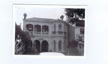 St Kilda Historical Society
Photograph, 12 Burnett St, St Kilda, c.1960s
black and white photograph, unmounted, original, good condition12 Burnett Street Built 1880s -
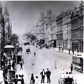 St Kilda Historical Society
Photograph, Collins St Melbourne, c. 1897
black and white photographCollins Street, (looking east) 1897 -
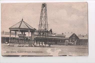 Wangaratta RSL Sub Branch
Postcard, F C Lloyd, 1916
From the album of WWI soldier William West (1268) of the 29 Infantry Battalion, 5th Pioneers Battalion. This collection of postcards, photographs and clippings were sent between William and his family and loved ones during the years he was on active service. Black and white photograph/postcard of Band Stand Band Stand, Albert Street, Creswickalbum, photo album, newspaper clippings, postcard, wwi, creswick -
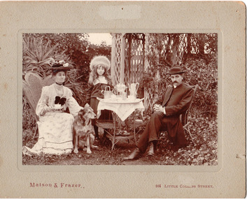 Hume City Civic Collection
Photograph, c1907
The Rev. Charles Edward Gayer was the vicar at St. Mary's Church of England in Sunbury during the early decade of the twentieth century.A sepia coloured photo of the Rev and Mrs Gayer with their daughter, Crystal, in a garden setting with an afternoon tea set up. The photo is mounted on a grey cardboard mat. There are a number of stains and some foxing on it and also a number of pin holes and an area of superficial paper loss centre top of the mat.Matson and Frazer 264 Collins Streetgayer, rev charles edward, - (mrs), george evans collection -
 Clunes Museum
Letter, 27TH APRIL 1956
LETTER WRITTEN TO MR. A. DAWSON BY THE CLUNES DISTRICT HOSPITAL SECRETARY MR. ROBERT JONES.LETTER FROM CLUNES DISTRICT HOSPITALMR. A. DAWSON ANGUS STREET CLUNESlocal history, document, letter, hospital -
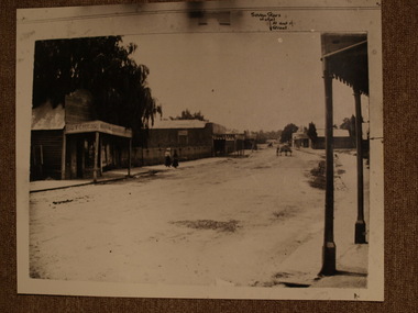 Clunes Museum
Photograph
FRASER ST. CLUNES TAKEN FROM TEMPLETON ST. APPROXIMATELY LOOKING TOWARDS SERVICE ST. AND THE SEVEN STARS HOTELSEVEN STARS HOTEL AT END OF STREETlocal history, photography, photographs, clunes township -
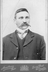 Stawell Historical Society Inc
Photograph, Portrait of gentleman in suite with large handlebar mustache
Collected by Dorothy Brumby in relation to Great Western ResearchB/W Portrait of gentleman with large handlebar mustache Armstrong Photo Princes Street Dunedin -
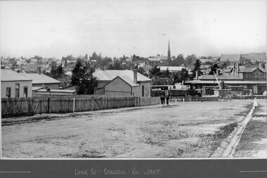 Stawell Historical Society Inc
Photograph, Streetscape of Stawell from Luke Street 1907
Shows Railway Station with Loading Crane. Coffee Palace can be seen near St Matthews Church. Grampians Freestone Guttering visible.Luke Street Stawell Vic c1907railways, transport -
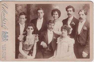 Rutherglen Historical Society
Photograph - Image, A. Marks & Co, 1880-1920 (Approximate)
Photograph of deaf, dumb & blind group (unknown) 5 males & 3 females."A. Marks & Co. Elgin Street Carlton"group photo, deaf, dumb, blind -
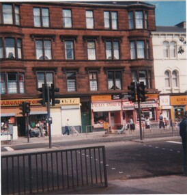 Rutherglen Historical Society
Image, Brian & Jeanette Jasper, 1987 Exact
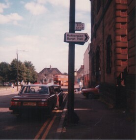
Brian & Jeanette Jasper, members of Rutherglen Historical Society, visited Rutherglen in Scotland in 1987 & took these photographs for the SocietySmall glossy print taken by Brian & Jeanette Jasper, when they visited Rutherglen Scotland in 1987 - unframed.On back of photo: "Rutherglen Main Street"rutherglen scotland, main street rutherglen -
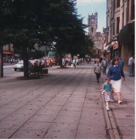 Rutherglen Historical Society
Image, Brian & Jeanette Jasper, 1987 Exact
Brian & Jeanette Jasper, members of Rutherglen Historical Society, visited Rutherglen in Scotland in 1987 & took these photographs for the SocietySmall glossy print taken by Brian & Jeanette Jasper, when they visited Rutherglen Scotland in 1987 - unframed.On back of photo: "King Street, Rutherglen"rutherglen scotland, king street rutherglen -
 8th/13th Victorian Mounted Rifles Regimental Collection
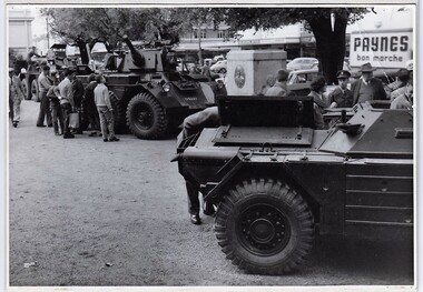
Photograph
In 1964 8th/13th Victorian Mounted Rifles was equipped with wheeled Armoured Vehicles. Driver training was undertaken by the Regiment during weekend training so as to have trained crewmen ready for tactical training at Annual exercise.Collection of photographs showing an armoured regiment of the Citizen Forces in the 1960s as it transitioned from wheeled armoured vehicles to tanks to M113 armoured personal carriers.Black and white photograph of three Armoured vehicles open for inspection in town square. Vehicles are Ferret Scout Car, Saladin Armoured Car and Saracen Armoured Command Vehicle." Recruiting display, Dean Street Albury " -
 Ballarat Tramway Museum
Slide - 35mm slide/s, Ben Parle, Apr. 1956
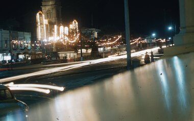
Kodachrome Transparency - 35mm slide - cardboard mount, with one side with red border and words "Kodachrome Transparency" top and bottom. On the other side is "Made in Australia" and "View from this side". Photo taken by Ben Parle 4/1956. Has slide No. "3" stamped in red in top corner. Photo taken from the Ballarat Post Office steps, looking across to the post office at night. Has the Town Hall and Sturt St. decorated with lights. "Sturt Street Ballarat" "4/56"tramways, trams, sturt st, royal visit, illuminations, town hall -
 Ballarat Tramway Museum
Slide - 35mm slide/s, Ben Parle, Apr. 1956
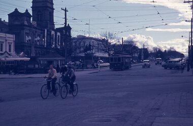
Agfacolour slide with words "Agfacolour" in blue top and bottom on one side, white cardboard mount with thick blue border on the printed side. Possibly hand done. Photo taken by Ben Parle 8/1956. Photo taken from the Ballarat Post Office footpath looking across to the Town Hall, with a single truck tramcar waiting on the north side, a bogie car on the south side, with a number of vehicles in the background. Slide is very dark/blue colour. The Town Hall has large numerals "100" in white, with the word "1855" apparent on the nearest side. The corresponding year is partially hidden by trees."Sturt Street Ballarat" "8/56"tramways, trams, sturt st, town hall -
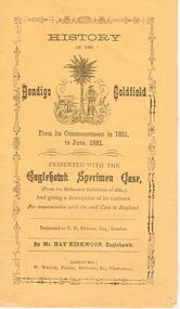 Bendigo Historical Society Inc.
Document - BENDIGO GOLDFIELD - HISTORY OF, FOR MELBOURNE EXHIBITION 1880
Yellow covered booklet 'History of the Bendigo Goldfield from its commencement in 1851 to June 1881' Presented with the Eaglehawk Specimen Case and giving a description of its contents, for transmission with the said case to England. Dedicated to G.D. Peters, Esq, London, by Mr. Hay Kirkwood, Eaglehawk. Inside first page ( un-numbered) 'The Bendigo Goldfield Compiled by Messrs Hay Kirkwood and Wm. Welch. The Rise and Progress. At the latter end of 1851, a few enterprising pioneers, with Captain Harrison, now police magistrate of Castlemaine, made their way from Forest Creek ( Castlemaine ) 30 miles distant, to a place on the Bendigo Creek, now called Golden Square, then a squatter's run, where rich auriferous ground was met with. The new soon spread far and near, and the world was soon startled with the intelligence that another very extensive goldfield had been discovered, the importance of which may be gathered from the fact that in the month of June, in the following year, six months after the first sod was raised, 80,000 ounces of pure native gold was taken by Melbourne.Printer: W. Welch, View Streetbendigo, mining, melbourne exhibition 1880 -
Bendigo Historical Society Inc.
Photograph - STRATHFIELDSAYE SHIRE BAND, early 1900's
Sepia photograph of the Strathfieldsaye Shire Band, showing thireen players and one leader. Many have ribboned hat bands, watch chains, Alberts, visible on left and right outer and centre members. All are suited and wearing hats. . Two wagons visible behind picket fence in background. Five members in front row are seated. On back in pencil ' from Mrs. Lowndes, McIvor Road. Back row Morgan Mulcare 1886, Harry Weiness, Joe Lewis, Jack Gladen 1870, Maurice Lewis 1884, Jim Griffin 1873/77/78 Jack Weiness, Ben Griffen, Frank McLean, Sitting : William Somerville 1858/79/82/85 Unknown, Thomas Somerville 1882/83 , Harry Manser 1885, Michael Sullivan 1867/68 MORE INFORMATION ON SHEETS BEHIND PHOTOR. Dermer Smith, Bull Street.organization, club/society, strathfieldsaye shire band -
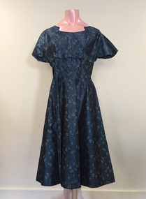 Kew Historical Society Inc
Clothing - Teal Blue Rayon Dress, Cann’s, 1950s
The Fashion & Design collection of the Kew Historical Society includes examples of women’s, men’s, children’s and infants’ clothing from the 18th, 19th and 20th centuries. Items in the collection were largely produced for, or purchased by women in Melbourne, and includes examples of outerwear, protective wear, nightwear, underwear and costume accessories.Dark blue green rayon dress self patterned with small flowers of a lighter colour. The short sleeved high waisted dress is fastened with a zip at back.Label: Cann’s, Swanston Street, Melbournecann's, georgina cann, women's clothing, day dresses, australian fashion - 1950s -
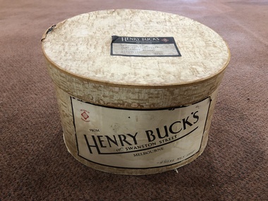 Mont De Lancey
Hat Box
Sent to H.N. Lord Esq. Flat 2 "Berwyn' 7 Glenroy Road Hawthorn Vic.Round light brown patterned cardboard hat box. Contains 2 men's hats - #'s 613 and 3044."Henry Buck's of Swanston Street Melbourne"hatboxes