Showing 250 items
matching bendigo agricultural society
-
 Bendigo Historical Society Inc.
Administrative record - The Land Act 1869
The Victorian Parliament passed Land Acts in 1860, 1862 and 1869, which offered settlers land within defined agricultural areas. Settlers paid for half of an allotment on selection at a uniform price of £1 per acre and paid rent on the other half for usually 7 years. By the end of the period, to obtain title to the land, settlers would have had to pay the balance of the purchase price and make certain improvements. (from Wikipedia)Blue book missing front cover, some loose pages. The book contains amendments to the land act 1869. throughout the book there are handwritten notes with names and localitiesRed pen mark at the front Land(?) 869. some of the nameswriten are: Sanderson, O'Brien, H. Jackson, R. Wharton, W. Porter, J. Stewart, Foley and Mortonland act, victorian legislation -
 Bendigo Historical Society Inc.
Ephemera - LYDIA CHANCELLOR COLLECTION: EPHEMERA
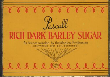
An orange butter scotch tin, yellow Pascall barley sugar tin both empty. A red hard cover book titled, 'Blackie's Science for Beginners - Agriculture.' London, Blackie & Son, Limited, 50 Ol.d Bailey, E.C. Glasgow and Dublin. Inside are the words 'Lydia Pethard NcCaskill St. Numurkah Sep. 26, 1901.lydia chancellor, collection, ephemera, tourism, tins, tin, travel, recreation, calendar, science, sciences, books, pets, animals, wales, united kingdom, agriculture, blackie's science for beginners series -
 Bendigo Historical Society Inc.
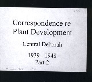
Book - CENTRAL DEBORAH MINE CORRESPONDENCE RE PLANT DEVELOPMENT PART 2
Black folder containing photocopied documents pertaining to the setting up and running of the Central Deborah Mine, Bendigo. 1939 - 1948. Original copies held in McColl,Rankin & Stanistreet Collection. Application for Permit. Ministry of Post War Reconstruction. War Organisation of Industry. Quotes, Tenders. Hume & Iser. T.J Jorgensen. Electricity Supply Department. Saunders & Ross. District Telephone Office. R Toma. Stock Exchange. Building Site Plan. Abbott Supply Co. F.W. Milne & Son. The Golden City Agricultural Implements. Department of Labour and National Service.Miller & Co. Thompson Engineering and Pipe Co. Gold Boring and Prospecting. Costs. J.l. Howard. A.J. William Electrical Instruments.bendigo, mining, central deborah gold mine -
 Bendigo Historical Society Inc.
Slide - FLEMING COLLECTION: 1950S BENDIGO SLIDE, 33 April 1957
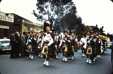
Bendigo 1950s. Bendigo Easter Fair 22/4/1957. Bagpipe Band in Myer Street. Northern Seed Poultry and Stock Food and Agricultural Seeds, one of Bendigo's Oil companys to the left of Northern Seed.Kodachromeevent, easter fair, bendigo easter fair, bendigo 1950s. bendigo easter fair 22/4/1957. bagpipe band myer street. northern seed poultry stock food agricultural seeds, bendigo's oil companys -
 Bendigo Historical Society Inc.
Document - Agriculture and Primary Industry Committees
Two pages handwritten notes on Agriculture and primary industry by John Ellison for discussion at the Country Party committee meetings. Part of the Aileen and John Ellison collectioncountry party, agriculture, primary industry -
 Bendigo Historical Society Inc.
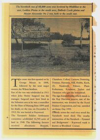
Newspaper - Newspaper articles - North Central Loddon Region
8375a: The Victorian soldier settlement scheme created in 1917 to lease farming land to soldiers and nurses returning from WW1. The Scheme was heavily criticised. Some reasons for this were the settlers' lack of capital, the size of the land allocated, and the prices of agricultural products both purchased and sold by the farmers. In the wake of WW2, the soldier settlement scheme was refined and, under the supervision of the Soldier Settlement Commission, was re-established. The Yarraberb Settlement was one of the settlements established in 1948. 8375b: Archibald Edmund "Archie" Robertson was born in Eaglehawk in 1884 to Martin Robertson and Anna Margaretha/Hannah Marguerita (nee. Weseloh/Wesloah). Robertson was a commissioned officer during WW1 and contributed to the welfare and advancement of the California Gully community. Following his death in 1922, following a fall from his bike, the community honoured Robertson with a memorial seat in 1923.A3 colour photocopies of newspaper articles pertaining to the North Central Victoria Region. Date of photocopy unknown. Location of original paper unknown (likely the Eaglehawk Times, unable to confirm). Both articles were cut from a larger paper. Article 8375a briefly describes the Yarraberb Solider Settlement. Article 8375b recounts the dedication of Archie Robertson's seat in California Gully. newspaper, eaglehawk heritage society, yarraberb soldiers settlement, soldier settlement commission, archie robertson, california gully, ww1, ww2 -
 Bendigo Historical Society Inc.
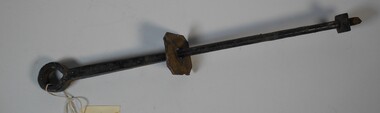
Functional object - Harris Collection Gate Hinge
Jonathan Harris operated a winery on the banks of the Axe Creek, Axedale in the 1850s.Large metal gate hinge with hole at top and thread at the bottom. Two square metal pieces - one moveable. Part of the Harris Collection.agriculture, farm, gate hinge, harris collection -
 Bendigo Historical Society Inc.
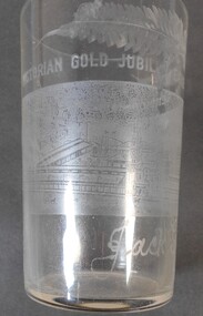
Memorabilia - Victorian Gold Jubilee Glass
The Victorian Gold Jubilee Exhibition, held at Bendigo from 13 November 1901 to 14 May 1902. The courts were numbered from one, or had titles like “Machinery”, “Agricultural”, “Naval & Military Court” and “Art”. The female visitors to the Exhibition were able to view exhibits deemed suitable for the fairer sex and located within their own “Women’s Court”. There were exhibits such as “Parasols & Umbrellas”, cotton and haberdashery from Manchester and Staffordshire, “Corsets & Embroideries” from Paris. The most valuable exhibits were mining machinery such as Taylor Horsfield’s £850 “Air Compressor & Rock Borer”. “Bohemian Glassware” brought down from Sydney was valued at £600. The profits from this Exhibition were used to fund the sculpture known as the Gold Monument, which still gazes along Pall Mall (from the McCrae Street end). The Exhibition’s Cash Book shows payments, which totalled £1160, were made to then up and coming sculptor C.D.Richardson. Recently a City of Greater Bendigo staff member used both these volumes to write a detailed report about this monument, for Heritage Victoria.Etched Drinking Glass to commemorate Victorian Gold Jubilee Exhibition Bendigo 1901-2 Decorated with a scene of Bendigo and fern fronds.Victorian Gold Jubilee Exhibition Bendigo 1901-2 Jack Gordonvictorian gold jubilee exhibition bendigo, 1901-2, jack gordon, bendigo -
 Bendigo Historical Society Inc.
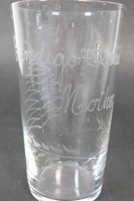
Memorabilia - Bendigo Exhibition Glass
The Victorian Gold Jubilee Exhibition, held at Bendigo from 13 November 1901 to 14 May 1902. The courts were numbered from one, or had titles like “Machinery”, “Agricultural”, “Naval & Military Court” and “Art”. The female visitors to the Exhibition were able to view exhibits deemed suitable for the fairer sex and located within their own “Women’s Court”. There were exhibits such as “Parasols & Umbrellas”, cotton and haberdashery from Manchester and Staffordshire, “Corsets & Embroideries” from Paris. The most valuable exhibits were mining machinery such as Taylor Horsfield’s £850 “Air Compressor & Rock Borer”. “Bohemian Glassware” brought down from Sydney was valued at £600. The profits from this Exhibition were used to fund the sculpture known as the Gold Monument, which still gazes along Pall Mall (from the McCrae Street end). The Exhibition’s Cash Book shows payments, which totalled £1160, were made to then up and coming sculptor C.D.Richardson. Recently a City of Greater Bendigo staff member used both these volumes to write a detailed report about this monument, for Heritage Victoria.Etched drinking glass. Bendigo Exhibition 1902 - Mother - Etched on front - Fern frond etched on back.Mother 1902, etched glass, bendigo exhibition 1902 -
 Bendigo Historical Society Inc.
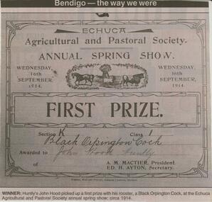
Newspaper - JENNY FOLEY COLLECTION: WINNER
BHS CollectionBendigo Advertiser ''The way we were'' from 2002. Winner: Huntly's John Hood picked up a first prize with his rooster, a black orpington cock, at the Echuca Agricultural and Pastoral Society annual spring show in 1914. The clip is in a folder.newspaper, bendigo advertiser, the way we were