Showing 2088 items matching " burke "
-
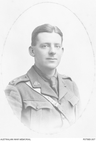 St Patrick's Old Collegians Association (SPOCA)
Photograph - Alumni, War Service, WW2, Burke
-
 Kew Historical Society Inc
Photograph, Stuart Tompkins Studio, Electricity Supply Poles, North Road, Ormond, 1965
Research provided by Stuart Tompkins Studio, Box Hill, into alternatives for median strip street lighting to be used in Burke Road, Kew. The photographers identified variants in different suburbs appropriate to Kew's needs.The series from which the photograph is drawn provides a snapshot by a commercial photographic studio of each named vicinity in 1965 as well as providing examples of public works infrastructure being commissioned by local government in the 1960s. The photos originally formed part of the Engineering Department's files in the City of Kew before being donated to the kew Historical Society.Electricity Supply Poles, North Road, Ormond, 1965. Electricity supply poles photographed for the Kew City Council by Stuart Tompkins Studio. The photograph of North Road, Ormond west of Jasper Road, looking east depicts wooden poles carrying two lamps in a median strip and with two on each side alternately. It was noted that the supply wires were from one side only. The poles were described as 3′ above ground and 11.25″ in diameter. The plan was to use this approach for Burke Road, Kew. [There are three copies of this photograph in the Collection.] Typed inscription on reverse: "Electricity Supply Poles. Photographed for Kew City Council 8/2/65. No.1 North Road - Ormond, west of Jasper Road, looking east. Wooden poles carrying two lamps in median strip and two on each side alternately just as is proposed for Burke Road, Kew. Supply wires from one side only. Poles 3' above ground 11 1/4" dia." Studio stamp: "Stuart Tompkins Studio. 547 Station Street, Box Hill. WX1439."stuart tompkins studio, street lighting, south road (moorabin) 1965, public infrastructure -- city of kew, city of kew -- engineer's department -
 Kew Historical Society Inc
Photograph, Stuart Tompkins Studio, Electricity Supply Poles, North Road, Ormond, 1965
Research provided by Stuart Tompkins Studio, Box Hill, into alternatives for median strip street lighting to be used in Burke Road, Kew. The photographers identified variants in different suburbs appropriate to Kew's needs.The series from which the photograph is drawn provides a snapshot by a commercial photographic studio of each named vicinity in 1965 as well as providing examples of public works infrastructure being commissioned by local government in the 1960s. The photos originally formed part of the Engineering Department's files in the City of Kew before being donated to the kew Historical Society.Electricity Supply Poles, North Road, Ormond, 1965. Electricity supply poles photographed for the Kew City Council by Stuart Tompkins Studio. The photograph of North Road, Ormond west of Jasper Road, looking east depicts wooden poles carrying two lamps in a median strip and with two on each side alternately. It was noted that the supply wires were from one side only. The poles were described as 3′ above ground and 11.25″ in diameter. The plan was to use this approach for Burke Road, Kew. [There are three copies of this photograph in the Collection.] Typed inscription on reverse: "Electricity Supply Poles. Photographed for Kew City Council 8/2/65. No.1 North Road - Ormond, west of Jasper Road, looking east. Wooden poles carrying two lamps in median strip and two on each side alternately just as is proposed for Burke Road, Kew. Supply wires from one side only. Poles 3' above ground 11 1/4" dia." Studio stamp: "Stuart Tompkins Studio. 547 Station Street, Box Hill. WX1439."stuart tompkins studio, street lighting, south road (moorabin) 1965 -
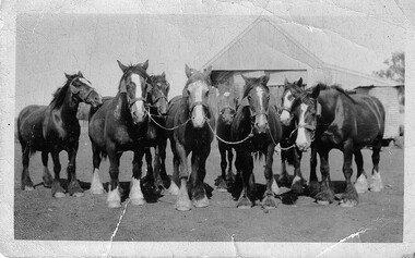 Hymettus Cottage & Garden Ballarat
Photograph, Archie Burke's Ploughing Team Dooboobetic
Mr William Burke settled at Dooboobetic near Donald in the 1860s his sons eventually working their own farms on subdivisions of the original property. Archibald (Archie) whose team is pictured had a portion named "Inverleigh". His daughter married Mr Michael Taffe of "Hymettus" Ballarat where the photographic archive survives. small snapshot image badly creased of team with inscription and print on reverse.Written on reverse "G'pa Burke's team. with printed words KODAK PRINT and ink stamp 431 -
 Whitehorse Historical Society Inc.
Article, Assurance on assets, 1994
Nunawading mayor, Cr Abbott receives an assurance from Local Government Board Chairperson, Leonie Burke, that unless an account had been set up to service a particular debt, all income belongs to the amalgamated council.Nunawading mayor, Cr Abbott receives an assurance from Local Government Board Chairperson, Leonie Burke, that unless an account had been set up to service a particular debt, all income belongs to the amalgamated council.Nunawading mayor, Cr Abbott receives an assurance from Local Government Board Chairperson, Leonie Burke, that unless an account had been set up to service a particular debt, all income belongs to the amalgamated council.local government finance, city of nunawading, city of box hill, city of whitehorse, amalgamations, burke, leonie, abbott, kevin -
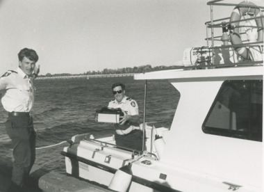 Lakes Entrance Historical Society
Photograph - Paynesville Water Police, Lakes Post Newspaper, 1/04/1996 12:00:00 AM
Water Police Snr Const. Tony Burke and Snr Const. Brian Hall of Paynesville Water Police docked at Lakes Entrance Victoria. An abandoned EPFRG emergency position indicating Beacon set off the alarm in Canberra initiating a full emergency response with helicopter, water police, coastguard and other units involved. The EPFRG was eventually located in a rubbish bin on a private property in Lakes EntranceBlack and white photograph of two Water Police Snr Const. Tony Burke and Snr Const. Brian Hall of Paynesville Water Police docked at Lakes Entrance Victoriacoast, defence services, police -
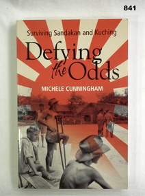 Bendigo Military Museum
Book, Lothian Books, Defying the Odds: Surviving Sandakan & Kuching, 2006
Defying the Odds tells the story of officers of B & E Forces interred at Sandakan & Kuching during World War II.Soft card cover. Red & cream cover illustrated front & back. Title on cover & spine in black letters. 237 cut edge pages. Black & white illustrations.On first page: Len Burke 12.10.06, Donated by Len Burke.books, military, history, valour -
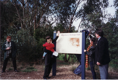 Whitehorse Historical Society Inc.
Photograph, Opening of Whitehorse Heritage Trail, 2/07/2001 12:00:00 AM
Heritage Trail funded by grant to the City of Whitehorse from Commonwealth of Australia to celebrate 100 years of Federation.Coloured photograph of Anna Burke, MHR, for Chisholm, and the Koori representative unveiling the Display Panel at opening of Whitehorse Heritage Trail at Gardiners Creek Reserve, Burwood. On Right: Cr. Bill Bowie, Mayor City of Whitehorse|On left: Lois Binnie, Heritage & Leisure Manager, City of Whitehorsewhitehorse heritage trail, city of whitehorse, burke, anna, bowie, bill, binnie, lois -
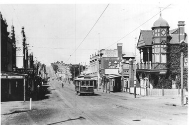 Melbourne Tram Museum
Photograph - Black & White Photograph/s, Bob Prentice, c1915
Black and white photograph of PMTT No. 57 in Burke Road Camberwell c1915. Tram showing route No. 12. Possibly at Mayston St. In the view is the State Savings Bank, a Real Estate agent, a snooker hall and a button shop. Photograph features on page 59 of Ian Brady's book on the PMTT, "Melbourne's Foremost Municipal Tramway". Photograph from the Bob Prentice Collection - from the Rose Series post-card P3639. Two copies held.Has caption on the photo "Burke Road, Camberwell c1920's" and in pencil on the rear 'RSCP 325", C1916 and in red ink "H57"trams, tramways, pmtt, burke road, camberwell, tram 59 -
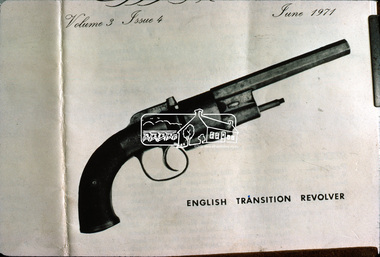 Eltham District Historical Society Inc
Slide, English Transition Revolver, c.1920
Colour positive photograph taken c. Dec. 1974 of an illustration (in a book?) dated June 1971 held by Nillumbik Historical Society. The illustration is of an English Transition Revolver, the same type of gun used by the Bushranger Burke to shoot and kill Henry Hurst in 186635 mm colour positive transparency Mount - Kodak Kodachrome CardProcessed Dec 1974burke, bushranger burke, english transition revolver, henry hurst, nillumbik historical society, pistol -
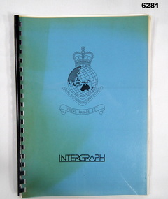 Bendigo Military Museum
Administrative record - Intergraph Maintenance Programme for Project "Newhart", Intergraph, Suite 6, 1401 Burke Rd, Kew East 3102, 28 August 1992
Intergraph Maintenance by Replacement Proposal (MBR) is the Terms and conditions for the implementation of "Project Newhart" ad the ongoing maintenance of the Automap 2 System. The Document was prepared by Intergraph's Account Manager, Norman John McMurtrie and addressed to LtCol R McHenry, CO Army Survey Regiment.A4 Booklet, Plastic cover, Blue front cover and white rear, Plastic ring binder, RASvy Badge and Text "Intergraph". Pages inserted loose and not secured, includes diagrams and text.royal australian survey corps, rasvy, fortuna, army survey regiment, army svy regt, asr -
 Eltham District Historical Society Inc
Film - Video (VHS), Phil Burke et al, Shire of Eltham Grants Commsission Submission (Series 69, Item 7), 1993
Shire of Eltham Archives: Series 69, Item 7 Opens with aerial views of the Shire, 85% of the shire covered by the Green wedge principal. Discusses the obligations required of the Shire to maintain the Green Wedge. The Shire covers over 27,000 hectares with a population in excess of 45,000 residents, more than 70% living in the southern 10% of the Shire in suburbs of Eltham, Montmorency, Lower Plenty and Research. 85% of the Shire in the more sparsely populated northern area which is covered by the Green Wedge. Council is committed to providing a parity of services to all residents such as garbage collection and maintenance of roads. Views of rubbish collection trucks in Montmorency. It is emphasised that the cost of these services in highly populated areas is relatively low whereas in the sparsely populated Green Wedge areas, considerable. There are hundreds of kilometres of roads throughout the Shire, many unmade and maintenance is high to check overhanging trees and erosion especially on the steep hills is expensive and disproportionate to servicing the population in the dense urban areas. Shows views of hilly gravel roads and graders at work maintaining them. Shows scenes of assessing planning applications in these rural areas which takes significantly more time as well as other services provided such as Meals on Wheels, building permits, Ranger services. Provision of recreational facilities in hilly areas requires the acquisition of expensive river flats (views of cricket ground surrounded by hills) and where not possible, costly earthmoving required. Also, views highlighting extensive tracks of natural habitat home to significant bird, animal and plant life. Shire emphasises its commitment highlighted by the Eltham Copper Butterfly which the Shire maintains small pockets of bushland to ensure its survival at significant expense (views of Pauline Toner Copper Butterfly Reserve.) Short interview with Pat Vaughan, Environmental Officer for the Shire discussing the Eltham Copper Butterfly who also mentions many other species in the Shire of high significance from bats to mammals to plants as well as the importance of the Green Wedge to Melbourne – the lungs of Melbourne - and ensuring the protection of very important habitat which requires a great deal of planning and management to look after. Views of Wingrove Park to emphasise this maintenance by machinery in some areas is too damaging and introduced species, etc must be removed by hand. Balancing the services and facilities expected by the community with the needs of the environment requires careful planning demands requires careful planning and the principals of the Green Wedge require constant attention in the face of growing need for housing. Director of Planning & Environment, Richard Allen advises there are approximately 1,300 planning permits and development applications each year ranging from simple subdivision, boundary realignments to further complicated non-urban developments for agricultural pursuits and the level of expertise required from architectural and engineering to land degradation, flora and fauna. Video finishes with aerial views and parklands, streetscapes and rural areas. VHS Video cassette Converted to MP4 file format 00:07:39; 89MBshire of eltham, video recording, shire of eltham archives, eltham shire council, eltham, building permits, cricket ground, development applications, eltham copper butterfly, garbage collection, graders, green wedge, lower plenty, meals on wheels, montmorency, pat vaughan, pauline toner reserve, planning applications, planning permits, ranger services, recreational facilities, research, richard allen, roads, rural areas, wingrove park, victoria grants commission -
4th/19th Prince of Wales's Light Horse Regiment Unit History Room
Order of Service, 50th Anniversary Memorial Service Monday 8th June 2015 Vietnam Veterans Commemorative Walk Seymour, June 2015
Order of Service, historical notes and admin matters filed in plastic sleeves in spiral bound file. -
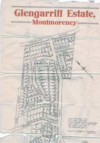 Greensborough Historical Society
Map, Glengarriff Estate Montmorency, 1938c
Estate Agent's plan of Glengarriff Estate, Montmorency, covering LPs 11334 and 11451. Bordered by Sherbourne Avenue, Calrossie Avenue, Montmorency Station and Price AvenueColour photocopy of subdivision map, on two A3 sheets glengarriff estate montmorency, sherbourne avenue montmorency, calrossie avenue montmorency, price avenue montmorency, montmorency station -
 National Vietnam Veterans Museum (NVVM)
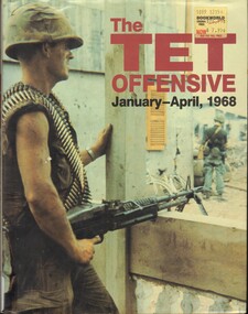
Book, Burke, Trace and Gleason, Mimi, The TET Offensive, January - April, 1968. (Copy 2), 1988
The 1968 Tet Offensive has been called the turning point of the Vietnam WarThe 1968 Tet Offensive has been called the turning point of the Vietnam War tet offensive, 1968, vietnam war -
 National Vietnam Veterans Museum (NVVM)
Book, Burke, Tracey, and Gleason, Mimi, The TET Offensive, January - April, 1968. (Copy 1), 1988
The 1968 Tet Offensive has been called the turning point of the Vietnam War.The 1968 Tet Offensive has been called the turning point of the Vietnam War. tet offensive, 1968, vietnam war -
 National Vietnam Veterans Museum (NVVM)
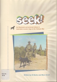
Book, Burke, Di,Small, Mary, Seek!: An Illustrated and Pictorial tribute to Australia's tracker dogs in the Vietnam War
Dedicated to the eleven faithful war dogs that served Australia as members o the combat tracking teams during the Vietnam War. they did not return home but are not forgotten.Dedicated to the eleven faithful war dogs that served Australia as members o the combat tracking teams during the Vietnam War. they did not return home but are not forgotten.dogs - war use, vietnam war, 1961-1975 - participation, australian - pictorial works -
 Robin Boyd Foundation
Book, Helen Burke, Good Fish from the Sea, 1965
Hardcover, No Dust Jacketwalsh st library -
Koorie Heritage Trust
Book, Burke, Christine, Analysis of the lithic assemblage from the Keilor archaeological site : site number : 7822/010, 1990
58 P. appendices; bib. graphs; figs. map.sites - conservation and protection. | keilor /? maribyrnong river (melbourne vic sj55-05) | excavations (archaeology) -- australia -- melbourne (vic.) sites - conservation and protection -
 Whitehorse Historical Society Inc.
Document, Schwerkolt Coat of Arms
Black and white representation of the Coat of Arms of the Schwerkolt Familynon-fictionBlack and white representation of the Coat of Arms of the Schwerkolt Familycoat of arms, schwerkolt -
RMIT GSBL Justice Smith Collection
Book series, Sweet & Maxwell Limited, Clerk & Lindsell on the law of torts, 1947
Previous owners: T. H. Smith, T. W. SmithTenth edition No. of volumes: 2 Volume range: Main & supplement Includes in back cover - "Fifth cumulative supplement (to August 31, 1952) by B. Cowderoy"torts -- great britain -
 Mrs Aeneas Gunn Memorial Library
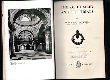
Book, Burke, The Old Bailey and its trials, 1951
A history of trials at the Old bailey in LondonIndex, ill, p.226.non-fictionA history of trials at the Old bailey in Londontrials - england, capital punishment - england -
The Beechworth Burke Museum Research Collection
Document - Archival, Burke Museum, Orton, 17-01-2007
-
The Beechworth Burke Museum Research Collection
Document - Archival, Burke Museum, Rosen, 16-06-2003
-
 Wodonga & District Historical Society Inc
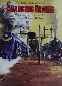
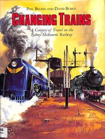
Book - Changing Trains : A Century of Travel on the Sydney-Melbourne Railway, Phil Belbin and David Burke, 1982
This book is the story of the hundred years of the Sydney-Melbourne railway connection. It is about the trains - the Express, the Limited, the Spirit of Progress, the Southern Aurora - and the locomotives that pulled them.non-fictionThis book is the story of the hundred years of the Sydney-Melbourne railway connection. It is about the trains - the Express, the Limited, the Spirit of Progress, the Southern Aurora - and the locomotives that pulled them.sydney-melbourne railway, train travel australia, railways australia -
 City of Kingston
Pamphlet - Black and white, Stott & Burke, Highland Estate Bentleigh, c.1915
Sales plan for land in the suburb of Bentleigh, along Collins and Ross Streets, bounded by Jasper Road.The developing urban area of Bentleigh within the City of Kingston. This land sale pamphlet illustrates the subdivision of land within the municipality and the changing demographic of the district as new houses are constructed.Black and white pamphlet advertising for private sale the Highland Estate, Bentleigh. Incorporates a map of the estate between Collins St and Ross St, bordered by Japser Road. Handwritten in grey pencil on map: additional subdivisions numbered 15-19 drawn along Ross St Handwritten in grey pencil on map: indecipherable annotations to subdivisions 1, 3 and 14land sales, bentleigh, estate -
 Victorian Railway History Library
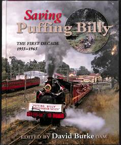
Book, Burke, David, Saving Puffing Billy: The First Decade 1955-1965, 2015
A history of the restoration of the 2'6" narrow gauge railway from Belgrave to Emerald in Victoria between 1955 to 1965.index, ill, p.217.non-fictionA history of the restoration of the 2'6" narrow gauge railway from Belgrave to Emerald in Victoria between 1955 to 1965.vr narrow gauge railways - victoria - history, puffing billy - victoria - history -
 Victorian Railway History Library
Book, Burke, David et al, Changing Trains, 1982
A century of travel on the Sydney-Melbourne railway from 1882 to 1982index, ill, maps. p.144.non-fictionA century of travel on the Sydney-Melbourne railway from 1882 to 1982railway services. routes. australia. sydney-melbourne line, railroads -- australia -- history -
 Victorian Railway History Library
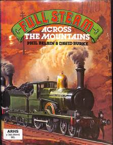
Book, Belbin, Phillip et al, Full Steam Across the Mountains, 1981
A history of the railway from Sydney to Lighgow over the Blue Mountains in New South Wales with paintings provided by Phil Belbin.index, ill, maps, p.144.non-fictionA history of the railway from Sydney to Lighgow over the Blue Mountains in New South Wales with paintings provided by Phil Belbin.railroad construction - new south wales - history, railroad operations - new south wales - history