Showing 505 items
matching bushland
-
 Eltham District Historical Society Inc
Photograph, Liz Pidgeon, Heritage Excursion; East of Eltham, 6 Sep 2014, 20 May 2017
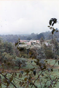
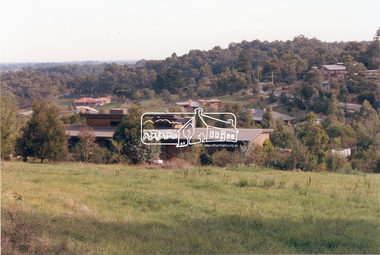
Newsletter No. 218, September 2014 September Excursion - East of Eltham Walk In Newsletter No. 197, March 2011, there was a brief history of Crown Allotment 15 Section 5 Parish of Nillumbik (CA 15) a parcel of land of a quarter of a square mile extending from Eucalyptus Road to Reynolds Road at the eastern extremity of Eltham. From the 1940s it was known as Stokes orchard. In later years it has been subdivided for residential purposes but leaving significant areas as power line and water supply reserves and bushland reserves that are habitat for the threatened For our excursion on 6th September we intend to walk through CA 15 to a bushland reserve east of Reynolds Road. The walk will traverse the boundary between suburban Eltham and the non-urban areas to the south and east. This is a pleasant walk through residential areas and bushland. Along the way we will discuss the early and more recent history of CA 15 as well as local natural history and geology. This walk is about 3.5 km in length and will take 2 to 2.5 hours. It will start at 2pm at the corner of Eucalyptus Road, Pitt Street and Nyora Road.Born Digitaleltham east, eltham district historical society, heritage excursion, activities, nyora road, reynolds road, gum tree road reserve, diosma road, stokes orchard, eucalyptus road -
 Eltham District Historical Society Inc
Photograph, Liz Pidgeon, Heritage Excursion; East of Eltham, 6 Sep 2014, 20 May 2017
Newsletter No. 218, September 2014 September Excursion - East of Eltham Walk In Newsletter No. 197, March 2011, there was a brief history of Crown Allotment 15 Section 5 Parish of Nillumbik (CA 15) a parcel of land of a quarter of a square mile extending from Eucalyptus Road to Reynolds Road at the eastern extremity of Eltham. From the 1940s it was known as Stokes orchard. In later years it has been subdivided for residential purposes but leaving significant areas as power line and water supply reserves and bushland reserves that are habitat for the threatened For our excursion on 6th September we intend to walk through CA 15 to a bushland reserve east of Reynolds Road. The walk will traverse the boundary between suburban Eltham and the non-urban areas to the south and east. This is a pleasant walk through residential areas and bushland. Along the way we will discuss the early and more recent history of CA 15 as well as local natural history and geology. This walk is about 3.5 km in length and will take 2 to 2.5 hours. It will start at 2pm at the corner of Eucalyptus Road, Pitt Street and Nyora Road.Born Digitaleltham east, eltham district historical society, heritage excursion, activities, nyora road, reynolds road, gum tree road reserve, diosma road, stokes orchard, eucalyptus road -
 Stawell Historical Society Inc
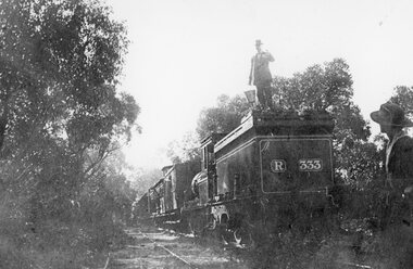
Photograph, Heatherlie Quarry with Engine and carriages on the rail track
Heatherlie Quarry. Engine and carriages on rail trackTwo Black and White Photgraphs 213-4 One showing two people. One woman in the fore ground and one Male standing on the back of a Steam eanine behind carraiges. This photo is estimated to be taken between 1923- 1925.. 213-4a Black and White Photgraph showin train carriages in bushland with hills behind the carriages, and train tracks in foreground.stawell grampians industry -
 Eltham District Historical Society Inc
Document - Series Listing, Fraser Faithfull et al, Series 65: Russell Yeoman's 30 Years Service Function, negatives, 2000
13 colour negatives taken on the occasion of Mr Russell Yeoman's 30 years service celebrations. Mr Yeoman worked in Shire Planning. Also on same film (included in this Series) are 12 colour negatives of rural Shire scenes, including a road running through bushland.shire of eltham archives, series listing -
 City of Moorabbin Historical Society (Operating the Box Cottage Museum)
Photographs, 7 x B&W Circa 1918 Cheltenham Methodist Youth Group, Circa 1918 Photos of Cheltenham Methodist Youth Group, 1918
Circa 1918: Various Photos of the Cheltenham Methodist Youth Group. Row 1 and 2: "At Flinders". Row 3: 1st Left, "Holidaying at Cockatoo". in 1852 Stephen Charman, who had arrived in Melbourne 1842 aged 21 years as one of Henry Dendy's emigrants, purchased 160 acres in Spring Grove ( now Cheltenham). Stephen and his family lived in a wattle and daub hut and worked hard to establish a market garden, poultry and pig farm. The first Methodist Church Services were held at their home. In 1855 Stephen gave 1 acre of his land on Balcombe Road to the Methodist Church for a School, Burial ground and a Chapel which was built in 1857.The Methodist Church, Balcombe Road was the 2nd religious building to be erected in Spring Grove now known as Cheltenham c 18577 small black and white photographs of the Cheltenham Methodist Youth Group at Flinders, Cockatoo and unkown locations, c 1918 . First 3 photos are of male cyclists on a trip to Flinders, Victoria. Photo 4 shows 6 ladies and a man on holiday at Cockatoo in the Dandenong Ranges ,Victoria . Photos 5 to 7 show men, women and children in bushland surroundings of unrecorded locations.Photo 1 - 3 on back : Flinders 1918 Photo 4 left on back : Holiday at Cockatoo right on back : Whitehead Photo 5-7 nilcheltenham, cheltenham methodist youth group, 1914, 1918, charman stephen, gettens mary, spring grove, methodist church, charman road, balcombe road, dendy henry, henry dendy's special survey 1841, youth groups, social groups, market gardners, early settlers, pioneers, dairy farmers, poultry farmers, pig farmers,moorabbin, brighton, -
 Bendigo Historical Society Inc.
Document - KANGAROO FLAT GOLD MINE COLLECTION: MEMO WESTERN MINING CORPORATION TO D.F. WRIGHT AND R. WRIGHT
Memorandum 29th February 1984 from Western Mining Corporation to T.E. Johanson, subject 'Bendigo'. Consent to drilling proposals and exploration licence for : Prince of Wales, Marong portion, bushland reserve and Eaglehawk portion Birds, Crown Land within Shire Spring Gully, area outside water reserve, classified as a Regional Park. In each of these categories exploration and mining is a permitted use.bendigo, gold mining, drilling proposals, bendigo, goldmining, drilling, t.e. johanson, planning permits, d. evans, r. wright. -
Canterbury History Group
Photograph - Weymouth Family on picnic to Warrandyte
Black and white photograph of Weymouth family on the way to a picnic in Warrandyte with the horse and cart from the hardware shop in Canterburycanterbury, warrandyte, weymouth family, horses, horse drawn vehicles, picnics, bushland, roads and streets -
 Clunes Museum
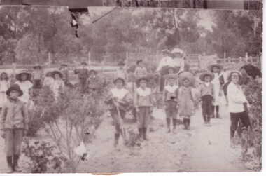
Photograph
MISS JAMES , A FORMER CLUNES RESIDENT TAUGHT AT STONEY CREEK SCHOOL 1906 - 1912. THE SCHOOL NESTLED IN THE BUSHLAND MISS JAMES TAUGHT AT CLUNES TILL 1930'S IN THE STONEY CREEK SCHOOL YARD, MISS JAMES AND STUDENTS LAID ROCKS IN THE SHAPE OF AUSTRALIA WHICH PROBABLY STILL REMAINS..1 BLACK AND WHITE PHOTOGRAPH SCHOOL STUDENTS AT STONEY CREEK SCHOOL IN THEIR GARDEN WITH TWO ADULTS IN BACKGROUND SCHOOL CLOSED IN 1916 .2 Envelope with provenance of the Stoney Creek School provided with the donation of the photographSAT PAPER ON REVERSE SIDElocal history, photography, photographs, schools, stoney creek -
 Eltham District Historical Society Inc
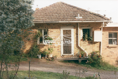
Photograph, 218 Pitt Street, Eltham, c.1985, 1985c
House was rented by Kim Tarpey between October 1983 and June 1985. It was one of the buildings originally part of Birds Orchard. Harold Bird was her landlord, a retired primary school teacher who, when she knew him was driving the mobile library bus. Her partner had him as a teacher at Montmorency Primary in grade 4. The house was next door to what is now a bushland reserve near the Pauline Toner Reserve. It was on the corner of Pitt and Arthur St - the driveway was near the roundabout and went off to the right of the driveway that now belongings to 220 Pitt street and which was bushland at the time. It was sold in 1985 and consequently demolished, a large house has replaced it. It was situated approximately where the front door of No. 218 is nowadays with the facade roughly in line with the now garage wall to the left of this front door.Digital file only - scanned from personal photo album on loan (27 images) List of images EDHS_04644-1.tif Kitchen window looking towards Eucalyptus Road, 218 Pitt Street, Eltham, c.1985 EDHS_04644-2.tif 218 Pitt Street, Eltham, c.1985 EDHS_04644-3.tif 218 Pitt Street, Eltham, c.1985 EDHS_04644-4.tif Kitchen looking towards Pitt Street Reserve, 218 Pitt Street, Eltham, c.1985 EDHS_04644-5.tif 218 Pitt Street, Eltham, c.1985 EDHS_04644-6.tif Bathroom walkway/laundry, 218 Pitt Street, Eltham, c.1985 EDHS_04644-7.tif 218 Pitt Street, Eltham, c.1985 EDHS_04644-8.tif 218 Pitt Street, Eltham, c.1985 EDHS_04644-9.tif 218 Pitt Street, Eltham, c.1985 EDHS_04644-10.tif 218 Pitt Street, Eltham, c.1985 EDHS_04644-11.tif 218 Pitt Street, Eltham, c.1985 EDHS_04644-12.tif 218 Pitt Street, Eltham, c.1985 EDHS_04644-13.tif 218 Pitt Street, Eltham, c.1985 EDHS_04644-14.tif 218 Pitt Street, Eltham, c.1985 EDHS_04644-15.tif 218 Pitt Street, Eltham, c.1985 EDHS_04644-16.tif 218 Pitt Street, Eltham, c.1985 EDHS_04644-17.tif Lounge window looking towards Mount Pleasant Road, 218 Pitt Street, Eltham, c.1985 EDHS_04644-18.tif Fire place in lounge, 218 Pitt Street, Eltham, c.1985 EDHS_04644-19.tif Fire place in lounge, 218 Pitt Street, Eltham, c.1985 EDHS_04644-20.tif View from lounge room window looking towards corner of Eucalyptus and Mount Pleasant roads, 218 Pitt Street, Eltham, c.1985 EDHS_04644-21.tif View from lounge room window looking towards corner of Eucalyptus and Mount Pleasant roads, 218 Pitt Street, Eltham, c.1985 EDHS_04644-22.tif View from lounge room looking towards Pitt Street and Wattle Grove, 218 Pitt Street, Eltham, c.1985 EDHS_04644-23.tif View from lounge room looking towards Pitt Street and Wattle Grove, 218 Pitt Street, Eltham, c.1985 EDHS_04644-24.tif 218 Pitt Street, Eltham, c.1985 EDHS_04644-25.tif Back garden showing previous tank stumps. There was a hole in the wall where a possum got through, 218 Pitt Street, Eltham, c.1985 EDHS_04644-26.tif View from back fence looking towards Pitt Street and Wattle Grove, 218 Pitt Street, Eltham, c.1985 EDHS_04644-27.tif View from back fence on to Eucalyptus Road. Pitt Street Reserve to the right, 18 Pitt Street, Eltham, c.1985218 pitt street, eltham, houses, birds orchard, harold bird, kim tarpey, eucalyptus road -
 Eltham District Historical Society Inc
Photograph, View from lounge room looking towards Pitt Street and Wattle Grove, 218 Pitt Street, Eltham, c.1985, 1985c
House was rented by Kim Tarpey between October 1983 and June 1985. It was one of the buildings originally part of Birds Orchard. Harold Bird was her landlord, a retired primary school teacher who, when she knew him was driving the mobile library bus. Her partner had him as a teacher at Montmorency Primary in grade 4. The house was next door to what is now a bushland reserve near the Pauline Toner Reserve. It was on the corner of Pitt and Arthur St - the driveway was near the roundabout and went off to the right of the driveway that now belongings to 220 Pitt street and which was bushland at the time. It was sold in 1985 and consequently demolished, a large house has replaced it. It was situated approximately where the front door of No. 218 is nowadays with the facade roughly in line with the now garage wall to the left of this front door.Digital file only - scanned from personal photo album on loan218 pitt street, eltham, houses, birds orchard, harold bird, kim tarpey, eucalyptus road -
 Eltham District Historical Society Inc
Photograph, View from back fence looking towards Pitt Street and Wattle Grove, 218 Pitt Street, Eltham, c.1985, 1985c
House was rented by Kim Tarpey between October 1983 and June 1985. It was one of the buildings originally part of Birds Orchard. Harold Bird was her landlord, a retired primary school teacher who, when she knew him was driving the mobile library bus. Her partner had him as a teacher at Montmorency Primary in grade 4. The house was next door to what is now a bushland reserve near the Pauline Toner Reserve. It was on the corner of Pitt and Arthur St - the driveway was near the roundabout and went off to the right of the driveway that now belongings to 220 Pitt street and which was bushland at the time. It was sold in 1985 and consequently demolished, a large house has replaced it. It was situated approximately where the front door of No. 218 is nowadays with the facade roughly in line with the now garage wall to the left of this front door.Digital file only - scanned from personal photo album on loan218 pitt street, eltham, houses, birds orchard, harold bird, kim tarpey, eucalyptus road