Showing 3432 items
matching distances
-
 Eltham District Historical Society Inc
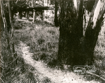
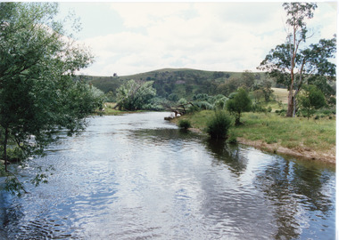
Photograph, Tree and Trestle Bridge, Eltham
Black and white photograph showing a track winding past an old gum tree towards the Trestle Bridge at Eltham in the distancepioneers and painters, bridges, eltham -
 Hume City Civic Collection
Photograph
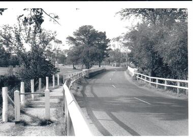
In the 1970s the bluestone bridge over Jackson's Creek ceased to be used and a wider bridge was constructed to its north. The curved approach to the bridge was taken out of the road and the old approach area was redeveloped and is now Apex Park.A black and white photograph of the old stone bridge over Jackson's Creek in Macedon Street. A utility is in the distance approaching the bridge.macedon street, jackson's creek, bridges, transport, apex park, sunbury, jackson's creek bridge, george evans collection -
 Hume City Civic Collection
Photograph, c late 1990s
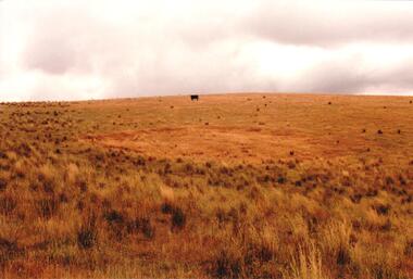
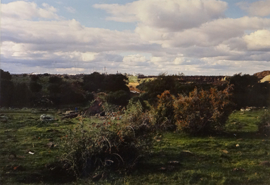
The series of 9 photographs were taken to be included in a study of archaeological sites and Aboriginal rings in the Sunbury area. Five earth rings which are thought to be associated with male initiation ceremonies have been identified in Sunbury. Only 3 others have been found in the rest of Victoria. Despite rapid development in the area, those sites are protected heritage sites.A coloured photograph of an Aboriginal Ring which is a proclaimed sacred site on an open grassy hillside. A black cow is standing in the distance.aboriginal culture, aboriginal rings, sacred sites, george evans collection -
 Hume City Civic Collection
Photograph, c 1990s
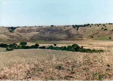
Canon Gully is situated about 2 km upstream from the railway bridge at Rupertswood. In 1864 it was the site for the military encampment of the Victorian Volunteer Forces. William Clarke allowed the military to stage the annual event on his property. Further encampments were held on this site in 1874 and 1877.A coloured photograph of a wide valley with cleared hills in the background. The tree lined creek or watercourse is across the middle distance of the image.canon gully, rupertswood estate, encampments, clarke, william j. t. 'big bull', victorian volunteer forces, george evans collection -
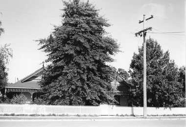 Stawell Historical Society Inc
Photograph, Terang
"Terang" - 33 Ligar St. - Hans Mitchell's HouseB/W Photograph: weatherboard House with verandah mostly hidden by tree. Picket fence and Power pole in mid-distance.stawell residence homes, terang, mitchell -
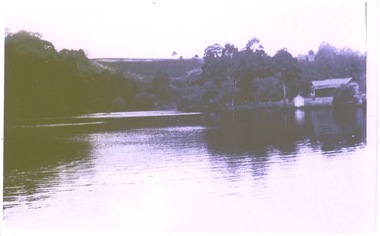 Hume City Civic Collection
Photograph, The Nook, c1940
The Nook in Sunbury is situated on a wide and deep bend in Jacksons Creek. Today the area is a popular site for passive recreation with a walking path along the Jacksons Creek. The house on the RHS of the photograph was situated near Powlett Street.Before the Aquatic Centre was built in Sunbury the swimming pool at The Nook was the town's swimming pool for many years. Seats and a change area were at the site.A black and white photograph of a large bend in a river with a house built on its riverbank and another dwelling on the hillside in the middle distance.the nook, swimming, jacksons creek -
 Hume City Civic Collection
Photograph
The photograph is of the lake and grounds at Rupertswood. When the lake was first constructed is was said to be in the shape of Australia. It was also the place where many a romance started as couples met while being rowed across it in a Venetian style gondola.The lake at Rupertswood was a popular place where the Clarke family entertained their guests and was a significant landmark feature on the property.A non-digital black and white photograph with a cream border of a large lake set in an expansive garden with a large mansion in the distance.lakes, rupertswood mansion, gardens, sir wiliam john clarke, lady janet clarke -
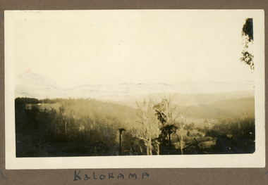 Mt Dandenong & District Historical Society Inc.
Photograph
The photograph is from the album of Ivy My Child. The area depicted would be looking across the Kalorama Valley with the visible roof tops being the homes of the early settler families. Ivy May Child (1910 – 1989) was the daughter of Arthur Edward (Ted) Child (1878 – 1964) and Ethel May Madden (1888 – 1970). Ted Child was the son of Matthew Francis Child (1839 – 1933) and Martha Jeeves (1857 – 1926). He was the grandson of one of the early pioneers Francis Child. Ivy grew up on the family property on Childs Road and took many photographs. Most of these are glued into her photo album. The album covered the years from c1927 – 1932. Ivy married Henry William Burgess (1906 – 1968) in 1944. The photographs remain in their original state in the album with individual copies made. Black and white photograph with trees and bushes in the foreground and hills in the distance. White shapes scattered throughout the centre are the roofs of buildings.Written below the photograph in album: Kaloramakalorama valley, kalorama -
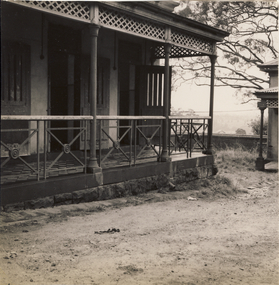 Kew Historical Society Inc
Photograph, Veranda, Kew Mental Hospital, 1954, 1954
This photograph is one of approximately 43 original photographs and photocopies of buildings, patients and staff assembled in a red covered, spirally bound photograph album (the album itself is now discarded and the images stored separately). The images in the album cover the period from the 1870s to 1965. A few photographs have inscriptions on the reverse; others had later separate labels in the album. The album was presumably compiled as a public record. It and other items came from the collection assembled by Dr Fred Stamp, the last medical superintendent of Willsmere Hospital before its closure in 1988. Original photographs have been uploaded to and described on Victorian Collections. The album itself is listed and linked separately showing the photographs in situ.A number of the photographs from the Willsmere Hospital album are confronting, especially given the condition of the buildings and facilities depicted, as well as the casual photographs of patients, which some viewers may find distressing. The album and its photographs are however an historically significant visual record of the Kew Mental Hospital, especially in the years 1951-1965.Black and white photograph of the edge of a veranda in the Kew Mental Hospital. What appears to be a HaHa! wall can be seen in the distance"1954"kew lunatic asylum, kew hospital for the insane, kew mental hospital, kew mental institute, willsmere mental hospital, willsmere hospital -
 Kew Historical Society Inc
Photograph - Urban landscape, 1860
An item from an outstanding and diverse photographic collection, assembled by members of the Christian and Washfold families of Kew.Black and white photograph looking across a valley to buildings in the distance. Similar locations in nos.41, 42, 43. 44.subdivisions -- kew (vic.), christian-washfold collection, landscape photography -
 Brimbank City Council Art Collection
Photograph, Robert Pointon, Huntsman chemical plan in distance, 1989
Local SceneHuntsman Chemical Plant in distance. Quarry now a tip to the right. Taken in South Sunshine near Kororoit Creek - AR0036 -
 Sunbury Family History and Heritage Society Inc.
Photograph, Beach excursion, c Early 1996
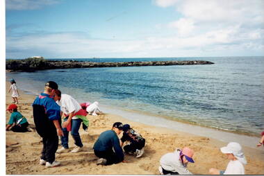
One of the activities the children enjoyed at their Williamstown Beach excursion was a snd castle competition, which they are busy constructing.A non-digital photograph of a group of children at a beach by the water's edge and digging in the sand. A rocky breakwater is across the middle distance.school excursions, bulla primary schooil, williamstown beach, sand castles -
 Sunbury Family History and Heritage Society Inc.
Photograph
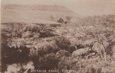
he photograph was taken of Jacksons Creek near the waterfalls and weir which are downstream from Macedon Street.A sepia photograph in postcard format of a creek with the water tumbling over rocks. The land in the distance rises above the surrounding valley.JACKSONS CREEK SUNBURYjacksons creek, sunbury -
 Sunbury Family History and Heritage Society Inc.
Photograph, 25th
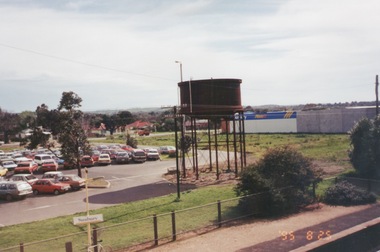
The photograph of Sunbury was taken from the pedestrian bridge at the railway station and is looking NW to Horne Street and beyond. The water tower in the foreground was used to pump water into the steam train engines. Then commercial development on the site was built shortly before this photograph was taken.A coloured photograph of an elevated view of Sunbury with a metal water tower in the foreground and a car park with commercial buildings in the middle distance.sunbury, sunbury railway station, horne street -
 Lakes Entrance Historical Society
Photograph - Buchan River, Tambo Shire, 1994 c
Colour photograph of the Buchan river, showing stream flowing between low banks, hills rising in distance. Buchan Victoria topography, waterways -
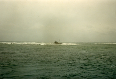 Lakes Entrance Historical Society
Photograph - Janet 1, Hammarstrom Ian, 1989 c
Colour photograph taken from a distance, showing the fishing boat Janet 1, stuck on the bar at Lakes Entrance, Victoria.ships and shipping, fishing industry, coast -
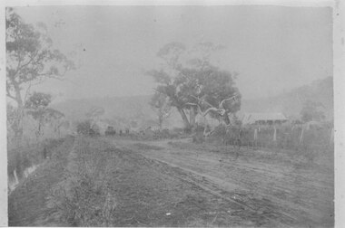 Halls Gap & Grampians Historical Society
Photograph - B/W
This is a photo of Mason's house, on the road to Ladysmith in the Mt William gold fields.The photo appears to have been taken on a foggy day. It shows an unsealed road flanked by a few gum trees and with a ditch containing water on the left. On the right in the middle distance there is a house with a twin pitched roof and a veranda at the front. In the distance on the road is a vehicle and what appears to be a few people. The are mountains in the far background.buildings, houses -
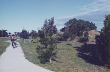 Lakes Entrance Historical Society
Photograph - Esplanade Lakes Entrance Victoria, Lakes Entrance Tidy Town, 1995 c
Colour photograph showing two children and an adult riding bicycles on pathway between south end of North Arm bridge and Bullock Island road. Middle distance left turn into Marine Parade foreground now site of skate park. In distance palm trees at entry to Esplanade Lakes Entrance Victoriarecreation, topography, roads and streets, parks -
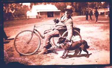 Wangaratta Historical Society
Three Wheeled Dog Cart, Three Wheeled Cart Pulled by Dog, Unknown
Mr Ernie Fitzgerald of Tarrawingee, traveled to Wangaratta, a distance of 14 Kilometres on Market days for his provisions. He was pulled along by his one of two dogs attached to a hand held leather strap (recounted by a witness who remembers Mr Fitzgerald's weekly visit to Wangaratta for supplies at The CoStore). This vehicle remains in possession of his family. This was an unique mode of transport in the 1930's, the witness was a child at the time and remembers Mr Fitzgerald and his dogs and the cart quite clearly. This is a unique mode of transport for the area, is documented and still in existence. WHS Inc were presented with 10,000 glass plate negative from Thelma & Vine Photographic Studios Murphy Street Wangaratta from the 1860's - 1950's. An example of a glass plate negative is featured above of Mr Ernie Fitzgerald of Tarrawingee who traveled to Wangaratta, a distance of 14 Kilometres on Market days for his provisions. He was pulled along by his one of two dogs attached to a hand held leather strap. (Recounted by a witness who remembers Mr Fitzgerald's weekly visit to Wangaratta for supplies). This vehicle remains in possession of his family. Unknownthree wheel steerable chair -
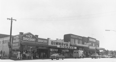 Ringwood and District Historical Society
Photograph, Maroondah Highway Central, Ringwood. Shops on the north-east corner of Melbourne Street and Maroondah Highway, c.1970
Black and white photographShops in photograph are 'Big N Discount Grocery, Dimmey's, ANZ Bank, Sound and Camera'. Safeway roof can be seen in the distance. -
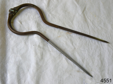 Flagstaff Hill Maritime Museum and Village
Dividers, Early 20th Century
Dividers are used by navigators to measure the distance between two points on a map or chart. Each point of the divider is places on a map point, then the distance between the points of the divider is measured against the scale of the chart or map. This helps determine the ship's path of travel, the distance travelled and the current location.Not very significant as not associated with any historical event or person, same pattern of dividers is available today from many retail outlets. Also item was probably made around 1940s to 1950sDividers; brass navigator's dividers with fine, stainless steel points. Made in Britain by W & H C (inscription). This navigational tool is used by a ship's navigator to mark the ship's position. Each end point of the divider is placed on a position on a chart or map, then the length between the points of the divider is measured on the chart's scale.Inscribed "British Made" and "W & H C". flagstaff hill, warrnambool, shipwrecked-coast, flagstaff-hill, flagstaff-hill-maritime-museum, maritime-museum, shipwreck-coast, flagstaff-hill-maritime-village, navigational dividers, navigational tool, dividers made by w & hc, w & hc britain -
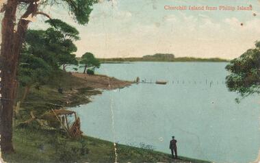 Phillip Island and District Historical Society Inc.
Photograph - Post Card, 1910's
One of 17 photographs donated by Olive BlameyColour postcard. Churchill Island in the distance taken from Phillip Island. Figure at water's edge. Figures, dog and boat in the centre. "Churchill Island from Phillip Island" Letter written by Marie of Everton Cowes to Millie addressed to Mrs H. Blamey, "Roslyn" The Parade Ascot Vale.churchill island, phillip island -
 Halls Gap & Grampians Historical Society
Photograph - B/W, C 1940s (?)
Photo shows an unsealed section of Grampians Rd. near Jimmy's Creek. The sharp profile of Mt Frederick can be seen in the distance.access routes, roads -
 Halls Gap & Grampians Historical Society
Photograph - B/W
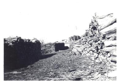
Reverse----- Stacks of wattle bark bundlesBlack and White photo showing stacks of bundled wattle bark ready for transporting to mill. Weather board house in far distance.Reverse----- Stacks of wattle bark bundlestimber industries, wattlebark stripping -
 Ringwood and District Historical Society
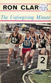
Book, The Unforgiving Minute (Ron Clarke) - Alan Trengove
Ron Clarke, among the greatest distance runners the world has seen, reveals the secrets behind his achievements to Alan Trengove -
 Benalla Art Gallery
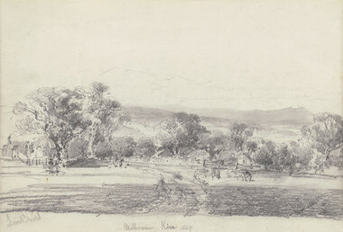
Drawing, Louis BUVELOT, Melbourne Kew (Yarra Glen), 1869
Born: Morges, Vaud, Switzerland 1814; Lived and worked: Brazil 1835-1852; Arrived: Melbourne, Victoria, Australia 1865; Died: Melbourne, Victoria, Australia, 1888ColonialLedger Gift, 1987Rural landscape with two animals beside a track leading towards buildings and outbuildings surrounded by trees with hills in distance. Timber frame.Recto: Signed "Louis Buvelot" in grey pencil in l.l.c of composition; Titled and dated 'Melbourne Kew 1869' in grey pencil in lower centre of compositiondrawing, landscape, figures, trees, colonial, road, animals -
 Tatura Irrigation & Wartime Camps Museum
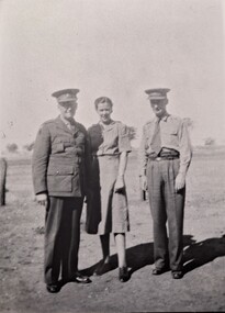
Photograph, Melrose, Tackeberry and Blight, Original 1942, copy 1989
WW2 Internment Camp 1 Tatura. Army staff and Nursing staff. Major Blight, Officer in Command of all the Tatura Camps (r), A.A.N.S. Sister Melrose; Colonel Tackeberry, Officer in Charge Camp 1 Tatura. 1942.Black and white photograph of two men and a lady, all in Army uniform. Post to the left side and trees in far distance behind. a.a.n.s., sister melrose, major blight, colonel tackeberry, internment camps -
Tatura Irrigation & Wartime Camps Museum
Photograph, New Fence Styles - Irrigation Channels, 1957
Taken by the photographer for Victoria State Rivers and Water Supply Commission.Large black and white photograph Concrete "fence" styles - One male worker handling sample in mid-distance, right of centre.Below photo: "New Fence Styles to enable easy access onto Commission Channel Reserves."irrigation, victoria state rivers and water supply commission, channel maintenance -
 Robin Boyd Foundation
Slide, Robin Boyd, 1970
Robin Boyd was appointed Exhibits Architect for the Australian Pavilion at Expo ‘70 in Osaka and travelled to Osaka several times in 1969-1970. Boyd designed the innovative Space Tube, which had over 25 exhibition boxes, projecting from it. Amongst the topics covered were Australian scientific innovation (including brain research, immunology, Antarctic research, Snowy Mountains Hydro-Electric Power Scheme, rainmaking, and the night sky), Australian sport, house interiors, car manufacturing, Australian music and art, and Japanese-Australian relations.Colour slide in a mount. Festival Plaza and the Tower of the Sun (in middle distance), Expo '70, Osaka, Japan. (Architect: Taro Okamoto.)Made in Australia / 1 / MAY 70M3expo 70, osaka, robin boyd, slide -
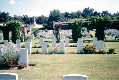 Hume City Civic Collection
Photograph
Further information needed about this photograph.A coloured photograph of a war cemetery with garden beds around the headstones and an arbor in the middle distance. A raised cross is overlooking the cemetery area.KALOMBABE COM. WAR CEMETERY/ BEAUTIFULLY KEPTwar graves, war cemeteries, kalombabe commonwealth war cemetery, george evans collection