Showing 244 items
matching h bridges
-
![Photograph - Construction of the F19 [Eastern Freeway], Ron Setford, October 1973](/media/collectors/550653872162f11fb04854aa/items/6808c3e9025de50d1e73220c/item-media/6808c404025de50d1e7324ef/item-fit-380x285.jpg) Kew Historical Society Inc
Kew Historical Society IncPhotograph - Construction of the F19 [Eastern Freeway], Ron Setford, October 1973
Ron Setford and his wife Grace Setford lived in Tanner Avenue, East Kew, from c.1946 to c.1995. A keen photographer, he recorded the changing face of Kew over a 20 year period. Apart from 30 photographs of built structures and places in Kew dating from 1960 and 1961, 145 of his 35mm colour slides chronicle the development of the F19 (later renamed Eastern) Freeway through the Yarra Valley in Kew over a five year period from c.1972 to c.1977. This important collection was donated to the Society by his granddaughter in 2025.This collection of 175 35mm slides is of local and statewide significance, owing to its subject matter, particularly the major development of road transport infrastructure during the 1970s with the construction of the Eastern Freeway. The photographer also took care to annotate and date most of his slides which enable the researcher to pinpoint temporal and spatial locations."Eastern Freeway / Chandler H/way to Fairfield / River Bridge Oct 73"ron setford, eastern freeway, f19 freeway -
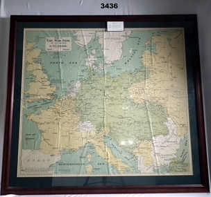 Bendigo Military Museum
Map - WAR ZONE EUROPE, FRAMED, Post WW1
Brown wooden frame with glass front & fawn paper backing. Mounted is a coloured map of the war zone in Europe. A thin white line represents the approximate line of contact between the opposing forces at the end of the 1st year of war in 1915.Printed top left: “Map of The War Zone in Europe by H E C Robinson Sydney - Copyright” On back: “Bethany Gallery, 116 Bridge Street, Bendigo”map, framed, war zone, european -
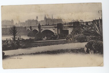 Emerald Museum & Nobelius Heritage Park
Postcard - Princes Bridge Postcard, c. 1900s
This postcard is part of an album of postcards which date from late 19th century to mid 20th century.This postcard is in an album of postcards dating from the late 19th century to mid 20th century and, as such, indicate the popularity of postcards during that time.Print postcard depicting Princes Bridge. Red one penny post stamp on back depicting Queen Victoria. On front: Under image: 'Princes Bridge.' On back: Left: '"Ailsa" / 10.7.05 / With best wishes / for present & / future. / Yours ever, / H. M. Craig' Right: 'Mr W. j Stuart / "Carlowrie" / Richmond Plains'postcard, 1900s -
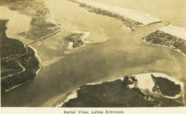 Lakes Entrance Historical Society
Postcard - Aerial view Lakes Entrance, H D Bulmer, 1922 c
Image clearly shows new alignment of Princes Highway around Jemmys Point and part of the original high road to the first bend above North Arm BridgeBlack and white postcard aerial view of the western area of the town, Bullock Island and Snake Island and waterways Lakes Entrance VictoriaAerial View Lakes Entrancewaterways, islands, township