Showing 11601 items matching " islands"
-
 Lakes Entrance Historical Society
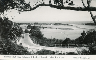
Postcard - Bullock Island, Bulmer H D, 1930C
2x black and white small format postcards both 6x9|1x tinted small format postcard 6x9|All above show inscription 'Road and Entrance'Black and white postcard of Princes Highway, entrance and Bullock Island taken from Kalimna Hill Lakes Entrance, VictoriaPrinces Highway, Entrance and Bullock Island, Lakes Entrancecoast, fences, roads and streets -
 Lakes Entrance Historical Society
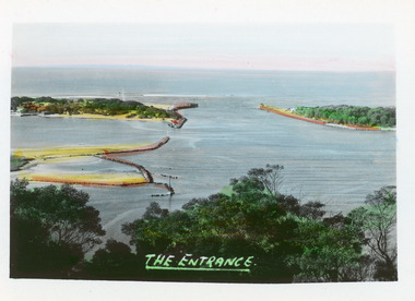
Postcard - The Entrance, Bulmer H D, 1940c
... Islands ...Hand tinted small format postcard of the entrance to the Gippsland Lakes, taken from Jemmys Point. It shows the rock groynes at Bullock Island with dredged sand filling the basin between island and groyne. Lakes Entrance VictoriaThe Entranceislands, waterways, topography -
 Lakes Entrance Historical Society
Photograph - Rigby Island, 1955c
... Islands ...Black and white photograph showing east end of Rigby Island, sand build up on Snake Island and rock groynes at Lakes Entrance, Victoria. Shrubbery in foreground, rock groynes in Reeves Channel, sand dunes in background.waterways, ocean, islands -
 Lakes Entrance Historical Society
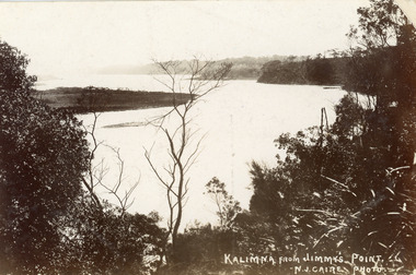
Postcard - Reeves Channel, Caire Nicholas John, 1905c
... Islands ...Also black and white enlargement 16 x 25Black and white postcard of the lake below Jemmys Point, Gippsland Lakes, showing Rigby Island opposite the steep cliffs of Kalimna and Nungurner shores of lakes. Small island, known as the Doughboy of Rigby Island. View taken from Jemmys Point with natural vegetation in foreground. Lakes Entrance VictoriaKalimna from Jimmys Pointislands, waterways, topography, boats and boating -
 Lakes Entrance Historical Society
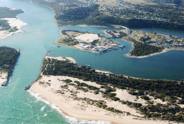
Photograph - Lakes Entrance, 2000
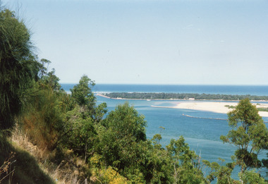
... Islands ...Colour photograph aerial view of the entrance, shows entry to North Arm, Cunninghame Arm, Bullock Island, part of Rigby Island, new North Arm Bridge in place, Club Hotel still in situ, small dredge working south west corner of Bullock Island. Lakes Entrance Victoriaislands, waterways, hotels, bridges -
 Phillip Island and District Historical Society Inc.
Photograph
One of a collection of over 400 photographs in an album commenced in 1960 and presented to the Phillip Island & Westernport Historical Society by the Shire of Phillip IslandPhotograph of Jessie McGregor's Island on the shoreline at Cunningham Bay. Cunningham Bay is located in the vicinity of the Phillip Island Grand Prix Circuit.local history, photography, jessie mcgregor's island, black & white photograph, cunningham bay, coastline, john jenner, bryant west -
 Phillip Island and District Historical Society Inc.
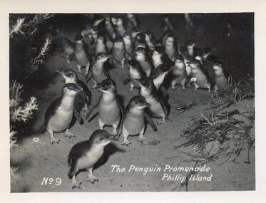
Photograph - Post Cards, A. J. Murray, 1940's
Part of a collection of photographs and postcards donated by Julie Barnett. Photos taken and purchased on her In-law's honeymoon during November 1946.12 Black & White Postcards various views around Phillip Island including the Penguin Parade, Suspension Bridge, Summerland Beach, Forrest Caves, The Nobbies and The Blowhole and Pyramid Rock.07. "The Penguin Promenade, Phillip Island" No. 9 08. "Photo Shop Series. The Jetty thro' the trees Cowes" 09. "Photo Shop Series. Phillip Island Bridge" 10. "Photo Shop Series. Phillip Island Bridge" 11. "Photo Shop Series. Forrest Caves. Phillip Island 12. "Photo Shop Series. Parade of the Penguins. Phillip Island" 13. "Photo Shop Series. Pyramid Rock. Phillip Island" 14. "Photo Shop Series. The Cascades at The Nobbies. Phillip Island" 15. "Photo Shop Series. Breakers at The Nobbies. Phillip Island" 16. "Photo Shop Series. The Nobbies and Seal Rocks. Phillip Island" 17. "Photo Shop Series. The Blowhole. Phillip Island" 18. "Photo Shop Series. Summerland Surf Beach. Phillip Island"wildlife - penguins, penguins coming ashore, penguins, the nobbies phillip island, the blowhole at the nobbies, the blowhole phillip island, pyramid rock, pyramid rock phillip island, cowes pier phillip island, cowes jetty, suspension bridge phillip island, phillip island suspension bridge, forrest caves phillip island, summerland surf beach phillip island, julie barnett -
 Phillip Island and District Historical Society Inc.
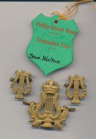
Badges, Phillip Island Band Tour to Tasmania, 1920's and 1947
Donated by Jill Walton from her husband's collection.Phillip Island Band Ticket and Lapel & Hat Badges. Ticket for Tasmanian Tour in 1947.On Ticket: Phillip Island Band Victoria - Tasmanian Tour 1947 - Stan Walton.phillip island band, phillip island band badges, phillip island band tour ticket, stan walton, jill walton -
 Phillip Island and District Historical Society Inc.
Photograph - Post Card, Early 20th Century
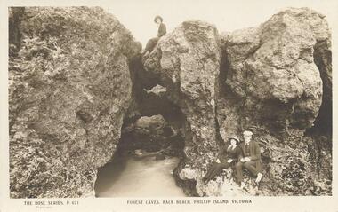
One of a collection of 6 photograps/postcards donated by T. H. HillSepia postcard of Forrest Caves, Phillip Island. Lady on top and lady and man in the foreground. "The KRose Series, P671" "Forest Caves, Back Beach, Phillip Island, Victoria"forrest caves phillip island, phillip island coastline, rock formations phillip island, t h hill -
 Phillip Island and District Historical Society Inc.
Sepia Photograph, 1920
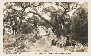
This Album was presented to the Earl of Stradbroke by Fathers of the Soldiers 16/2/1923. The photo is of Lovers Walk Cowes, showing sandy track with trees and shrubs. The inscription on the card says "Newhaven"Sepia Postcard of Lovers' Walk, Cowes, Phillip Island, Victoria. Has Newhaven on the photo.The Rose Series P. 687. The Lovers' Walk, Newhaven, Phillip Island, Victoriaphillip island, lovers' walk cowes, earl of stradbroke -
 Phillip Island and District Historical Society Inc.
Photograph, The Nobbies, Phillip Island, c 1926
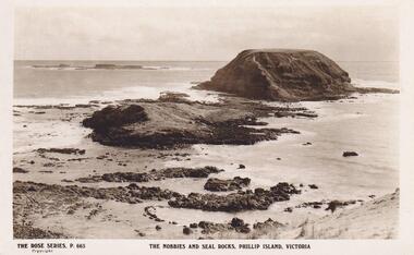
View of The Nobbies and Seal Rocks, Phillip Island, Victoria. The Rose Series P 665The Rose Series P.665 The Nobbies and Seal Rocks, Phillip Island, Victorialocal history, postcards, the nobbies, seal rocks, phillip island, sepia photograph, ian reiher -
 Lakes Entrance Historical Society
Photograph - The Entrance, 1986
... Islands ...Black and white photograph of the entrance from Bass Strait to the Gippsland Lakes. It also shows the rock groynes at Bullock Island filled with dredged sand to extend the island. Fishing boat coming through entrance. Lakes Entrance Victoriaislands, topography, waterways -
 Phillip Island and District Historical Society Inc.
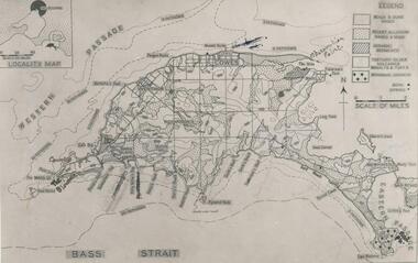
Photograph
One of a collection of over 400 photographs in an album commenced in 1960 and presented to the Phillip Island & Westernport Historical Society by the Shire of Phillip IslandPhotograph of a geological map of Phillip Islandlocal history, photography, phillip island map, black & white photograph, maps & mapping, phillip island, geology, john jenner, bryant west -
 Phillip Island and District Historical Society Inc.
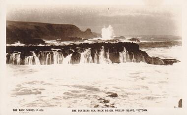
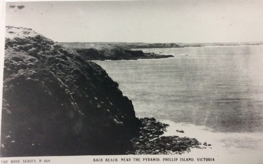
Photograph, Southern Coastline of Phillip Island, c 1926
Sepia Postcard of the southern coastline of Phillip Island The Rose Series P 670The Rose Series. P 670 The restless sea, Back Beach, Phillip Island, Victorialocal history, postcards, back beach, phillip island, sepia photograph, ian reiher, coastline -
 Glenelg Shire Council Cultural Collection
Photograph, Entrance Gates to Island Park Casterton, c. 1963
SOURCED FROM CASTERTON TOWN HALL (FORMER SHIRE OF GLENELG)Black and white photo showing entrance gates to Island Park CastertonBack: 'Entrance gates and track leading to oval at Island Park Casterton' - handwritten, green biro -
 Phillip Island and District Historical Society Inc.
Photograph, 1978/9
On 28th March 1801, Lieut. James Grant sailed across from Rhyll, landed and inspected Churchill Island. His men cleared some ground and planted seeds including Victoria's first crop of wheat. Named Churchill Island after John Churchill Esq. of Dawlish in the County of Devon.Coloured photograph of Churchill Island taken from Jetty on Phillip Island. Low tide is evident.local history, photographs, buildings - historical, rural industry, coloured photograph, john cook, churchill island -
 Lakes Entrance Historical Society
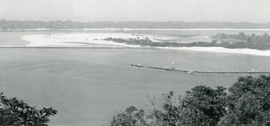
Photograph - The Entrance, 1992c
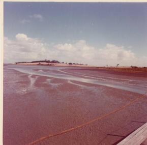
... Islands ...Colour photograph of the western side of the Entrance. It shows scrub covered hummocks, dredged sand dumped at Snake Island, rock groynes from island to lake, taken from lower side of highway at Jemmys Point. Lakes Entrance Victoriaislands, topography, waterways -
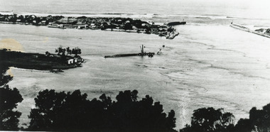
 Lakes Entrance Historical Society
Photograph - Bullock Island, Silver Reflections Studio, 1920c
... Islands ...Black and white photograph showing Bullock Island, Entrance to Bass Strait, buildings on sand dunes, yacht sailing on Cunninghame Arm, tourist launch in foreground, rock groynes around west end of Bullock Island. Lakes Entrance Victoriawaterways, room display, islands -
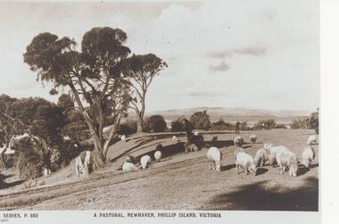 Phillip Island and District Historical Society Inc.
Photograph, Unknown
One of 20 photographs/postcards donated by Mary KarneyBlack & White copy of a postcard showing sheep grazing on pasture in Newhaven Phillip Island, with gentleman in the distance."The Rose Series P. 685" "A Pastoral, Newhaven, Phillip Island, Victoria"pastoral scene, newhaven pasture, sheep, phillip island, mary karney -
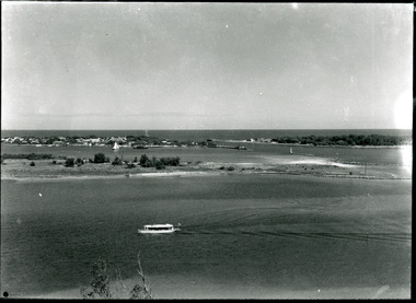
 Lakes Entrance Historical Society
Photograph - Gladys and George Legg, 1925 c
... Islands ...nine children Gladys and George Legg named, sitting outside a hut used as a changing room at the western end of Bullock Island a favoured swimming place as the water was always clean and fresh from tidal movement Lakes Entrance Victoria. Gladys Legg - centre front. George Legg at back wearing a cap Black and white photograph of a group of nine children Gladys and George Legg named, sitting outside a hut used as a changing room at the western end of Bullock Island a favoured swimming place as the water was always clean and fresh from tidal movement Lakes Entrance Victoriaislands, people, recreation facilities, buildings -
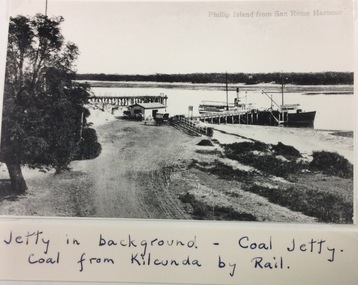 Phillip Island and District Historical Society Inc.
Photograph, Coal Jetty, San Remo
Part of a collection of Rose & Valentine Postcards. Copied by John Jansson 1984Black & White Postcard. View of Phillip Island from San Remo Harbour. Jetty in background - Coal Jetty. Coal comes from Kilcunda by Rail.Phillip Island from San Remo Harbour.local history, photography, photographs, postcards, black & white postcard copy., newhaven, phillip island, san remo, jetties, coal jetty -
 Phillip Island and District Historical Society Inc.
Photograph, Back beach near Pyramid Rock, Phillip Island
Part of a collection of 'Rose & Valentine' series of Post Cards. Copied by John Jansson 1984Black & White Postcard. Phillip Island showing Back Beach near Pyramid Rock, VictoriaThe Rose Series P668. Back beach near The Pyramid , Phillip Island, Victoria.local history, photography, photographs, postcards, black & white postcard copy, pyramid rock, phillip island. -
 Phillip Island and District Historical Society Inc.
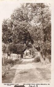
Photograph
Part of collection donated to the Museum by Mr. Bernard Grayden. 1975Postcard of track known as Lover's Walk through trees along foreshore at Cowes, Phillip Island."The Lover's Walk, Cowes, Phillip Island, Victoria". The Rose Series. P 3403local history, documents, postcards, walking track, cowes, phillip island, sepia postcard, lover's walk cowes, bernard grayden -
 Phillip Island and District Historical Society Inc.
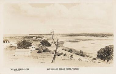
Sepia Photograph, 1920's
This album was presented to the Earl of Stradbroke by the Fathers of Soldiers and Returned Soldiers 16/02/1923Photograph of San Remo with early houses, possibly San Remo Hotel in the distance. Part of Phillip Island in back ground.Rose Series P701. San Remo and Phillip Island, Victoriaphillip island, san remo, earl of stradbroke, early houses -
 Lakes Entrance Historical Society
Photograph, 2005
... Islands ...Date made September 2005Colour photograph of the RMIT TAFE Educational Facility on Bullock Island, taken from Cunninghame Arm, in the back ground are communication towers on Kalimna Heights. The Kalimna escarpment contrasts with the low lying sand formation of Bullock Island. Lakes Entrance Victoriaislands, education, waterways -
 Lakes Entrance Historical Society
Photograph - Bullock Island, 1915c
... Islands ...On back of original 'To Rit with love from Arthur' (Arthur Seagrove - Head Teacher, Johnsonville Primary School - 1920)Black and white photograph of Bullock Island and the man-made entrance from Bass Strait. It shows the Western end of Bullock Island, some natural vegetation, jetty and timber groynes, trading vessel standing outside entrance. Lakes Entrance Victoriawaterways, islands, topography -
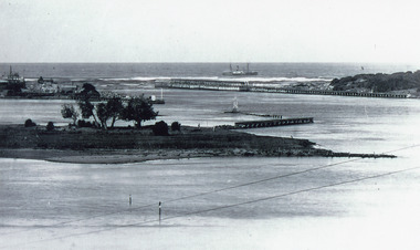
 Lakes Entrance Historical Society
Postcard - The Entrance, Valentine Series, The Entrance to the Gippsland Lakes, 1895c
... Islands ...Also a Black and white copy 11.5 x 18Colour tinted postcard of the entrance from Bass Strait to the Gippsland Lakes. It shows two small buildings on Bullock Island, groyne from Bullock Island across Cunninghame arm, sand inside entrance at western pier. Lakes Entrance VictoriaLakes Entrance from Jemmys Pointislands, topography, waterways -
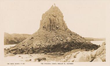 Phillip Island and District Historical Society Inc.
Sepia Photograph, 1920
This album was presented to the Earl of Stradbroke by Fathers of Soldiers on Phillip Island. The photo is of the Pyramid Rocks and surrounding rocks, Phillip IslandSepia photograph of Pyramid Rocks, Phillip IslandThe Rose Series P.663 The Pyramid, Cowes, Phillip Is., Victoriaphillip island, pyramid rock -
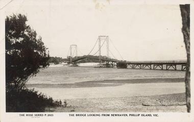 Phillip Island and District Historical Society Inc.
Photograph - Post Card, Suspension Bridge, 1940's
One of a collection of 18 photographs & postcards donated by Jill Yeoman. The Suspension Bridige was built during 1940. Postcard to Mrs Hughes & Lilly from Rita telling of a nice holiday visiting various towns and enjoying New Year's Eve fireworks on the Cowes beach.Black & White postcard of the Suspension Bridge from Newhaven, Phillip Island, to San Remo The Rose Series P. 2023. The bridge looking from Newhaven, Phillip Island, Vic.suspension bridge phillip island, phillip island bridge, jill yeoman -
Stawell Historical Society Inc
Painting, Will Rees, South Solitary Island NSW Coast, 1933
Framed Water Colour painting of island with cross on top. Sea with sailboat in foreground. 1933South Solitary Island NSW Coast Will Rees 1933 South Solitary Isl NSW