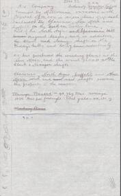
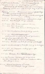
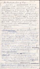
Showing 668 items
matching mine shafts
-
 Bendigo Historical Society Inc.
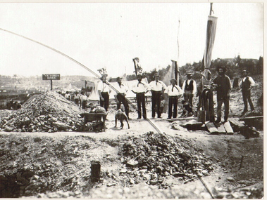
Photograph - COATH'S VICTORIA MINE, BENDIGO, c.1852
Black and white copy of photograph (in acid free sheets in folder) of eight men in foreground, three behind 'airsail' for mine ventilation. Men are wearing trousers, white shirts, with kerchiefs tied around their heads, straw boaters. Man on RH side dressed in darker clothing, standing on boards ( over a shaft ? ) Piles of mullock on LH side, wheelbarrow and dogs.. History: James Lerk 24/3/2000 - Coath's claim on Victoria Hill (a Fox photo?)place, mining site, coath's victoria mine, 'gold discovery' jas flett p244 -
 Bendigo Historical Society Inc.
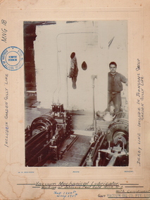
Photograph - JOHNSON'S REEF GOLD LUBRICATOR, c.1880-1890
Vacuum mechanical Lubricator Machinery (vacuum mechanical working at Johnson's Reef Gold, Mine No. 3. Lubricator. Man standing to RH side, hand on lever. Photo mounted on board. Inscriptions: included in Garden Gully Lane MNG18. Derby Line, included in Johnson's Group of Garden Gully Line. Shaft 1250ft. Winze 175ft.place, mining site, johnson's reef -
 Bendigo Historical Society Inc.
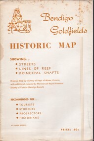
Document - BENDIGO GOLFIELDS HISTORIC MAP
Bendigo goldfields historic map showing streets, lines of reef, principal shafts. Original map (dept of Mines) with additional material by members of RHSV (Bendigo Branch) . Price 30c. Map; is folded into envelope for sale and storage.place, bendigo, map -
 Bendigo Historical Society Inc.
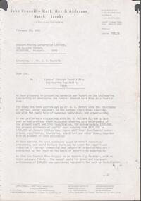
Letter - KANGAROO FLAT GOLD MINE COLLECTION: FILE RECORD RE CENTRAL DEBORAH TOURIST MINE STUDY, 3rd August 1983
File memo, from D.F. Evans, 3 August, 1983 re Central Deborah Tourist Mine Study, discussing the report from John Reynolds now lodged in the Preston Library. Main aspects of concern in report to Bendigo Mining NL are: 1. Proposal to redevelop shaft and establish tourist access 2. Calculation of volume of water in old flooded workings in North Deborah, Deborah, South Deborah and Deborah No. 2 mines 3. Volume of water involved in dewatering Central Deborah to 90m below the surface 4. Long term pumping reate required to control groundwater influx, estimated to be 90,500 gallons/day.bendigo, gold mining, central deborah gold mine, central deborah gold mine, dewatering, ground water, mining, bendigo mining nl -
 Bendigo Historical Society Inc.
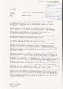
Document - KANGAROO FLAT GOLD MINE COLLECTION: ENGINEERING FEASIBILITYY STUDY CENTRAL DEBORAH GOLD MINE
40 page engineering feasibility study, with plans, for the development of the Central Deborah Tourist Mine, prepared by John Connell-Mott, Hay and Anderson, Hatch, Jacobs, consulting engineers, dated February 20th 1981. Enlargement of the shaft, lift installation, ventilation, dewatering, electrical installation are discussed. Latest costings range from $689,000 to $790,000.bendigo, gold mining, central deborah gold mine -
 Bendigo Historical Society Inc.
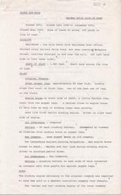
Document - KANGAROO FLAT GOLD MINE COLLECTION: FILE NOTE G. RALPH, WESTERN MINING CORPORATION
File note 6th August, 1980 re Bendigho Trust Central Deborah Mine. Notes on a meeting held Tuesday 5th between Darryl McClure, Bendigo Trust, Doug Cahill, promoter of Bendigo Mining NL and Dick Sandner, Bendigo Mining NL. Bendigo Mining NL seek permission to commence dewatering the Deborah shaft with a view to carrying out mining at deeper levels.bendigo, gold mining, central deborah gold mine -
 Bendigo Historical Society Inc.
Document - SOUTH NEW MOON GARDEN GULLY LINE OF REEF
Two page typed carbon copy of document, headed 'South New Moon, Garden Gully line of Reef', located one mile north from Eaglehawk post Office. An historical overview of the mine is provided with information regarding its location, depth of shaft, original company, engine house, air compressor, battery and years of operation. The steel poppet legs were approximately 85 ft high and had a greater slope than usual on the front legs. ' Said to be the best poppet legs on the field'.Albert Richardsonbendigo, mining, south new moon mine -
 Bendigo Historical Society Inc.
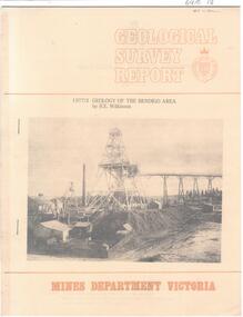
Document - CAROL HOLSWORTH COLLECTION: 1977 GEOLOGY OF THE BENDIGO AREA
Sixteen page booklet Geological Survey Report, Mines Department Victoria. 'Geology of the Bendigo Area' by H.E. Wilkinson. Photo of Lansell's 222 Mine on the New Chum Line, Bendigo. Tallest poppet head on the field, approximately 38 m high, with a shaft depth of 635 m.bendigo, mining, geological survey report -
 Bendigo Historical Society Inc.
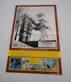
Document - CENTRAL DEBORAH GOLD MINE POSTER
Poster of central Deborah Gold Mine, Bendigo Victoria showing in black and white poppet head. Advertising: Bendigo goldmine open for inspection daily 10am - 5 pm guided tours by appointment phone 438070 or 436401. The Central Deborah gold mine, the last to close on the Bendigo field, was purchased early in 1970m by the Bendigo City Council for restoration and preservation as a typical Bendigo gold mine equipped with machinery , most of which was made in Bendigo. The Central Deborah Company was formed in 1939 to deepen an existing shaft sunk in 1912. Underground operations ceased in 1954. from 1942 to 1954 29,460 ounces of gold was won from 63,962 tons of ore.mine, gold, central deborah gold mine -
 Bendigo Historical Society Inc.
Document - ALBERT RICHARDSON COLLECTION: A LOOK AT A MINE, LOOKING AROUND LONG GULLY 1900'S
Blue exercise book in which is a handwritten, in blue biro, a description of the basic principles under which most of the Bendigo mines operated, titled ' A look at a mine'. Information provided on four compartment shafts, poppet heads, boilers, engine rooms, skyshafts, landing brace, engine drivers. In the back section of the book is a recount of what Long Gully was like in the early 1900's, titled 'Around Long Gully in the early 1900's'Albert Richardsonbendigo, mining, albert richardson -
 Bendigo Historical Society Inc.
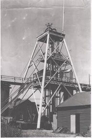
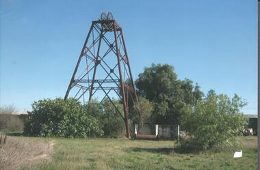
Photograph - NORTH DEBORAH GOLD MINE
Black and white photograph, copy, of the North Deborah Gold Mine poppet head, possibly taken in the 1940's. The trestle way and sky shaft used to convey ore to the landing brace are visible. Poppet head legs are metal and painted white. Corrugated iron sheds on right and in background. Air raid sirens on the top of the poppet head were used during World War 2 to warn the good citizens of Bendigo of any impending attack.bendigo, mining, north deborah gold mine -
 Bendigo Historical Society Inc.
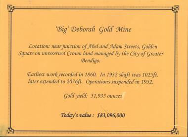
Photograph - DEBORAH GOLD MINE, GOLDEN SQUARE
Information display card regarding the 'Big' Deborah Gold Mine, located near the junction of Abel and Adam Street, Golden Square. Earliest work recorded 1860. Shaft 2076 feet. Operations suspended in 1952. Gold yield 51,935 ounces. Battery shed still on site containing a 5 head stamper which was originally a 20 head stamper. The battery was manufactured by Horwood's Foundry, Bendigo. Photos of mine site taken in 2012: a.Engine room concrete footings, iron work visible. Pepper corn trees in background. Pampas grass in foreground. Steel mesh fence on RH side, enclosing the poppet head site. b. Concrete footings, peppercorn tree in background. c. Corrugated iron shed constructed over the stampers. Steel mesh front. d. Steel poppet head, no winding wheel at top. Pampas grass in foreground. e.. Stamper shed and steel poppet legs in background enclosing dilapidated wooden poppet head legs. f. Close up image of weights in stamper room g.Winding wheel on stampers h.Looking upwards to top of stampersbendigo, mining, deborah gold mine -
 Bendigo Historical Society Inc.
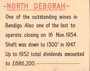
Document - NORTH DEBORAH , DEBORAH, CENTRAL NELL GWYNNE AND NAPOLEON GOLD MINES
Five interpretive cards used for displays, yellow with black and orange text, describing the North Deborah, Deborah, Central Nell Gwynne and Napoleon Gold Mines. a. North Deborah: closed 16th November 1954. Shaft was 1300 feet deep. Total dividends 686,200 pounds. b. Deborah: underground operations suspended 1952, shaft 2076 feet. c. Central Nell Gwynne: operations ceased at end of 1949, shaft depth 1933 feet. d. Napoleon: first subsidiary company formed by BML to carry out comprehensive programme of development along Napoleon anticline. Shaft 1054 feet in 1937 when opertions ceased. e. Devonshire Sands, formed in 1933. Cyanide leaching plants installed on sand tailings heaps at Bendigo.Albert Richardsonbendigo, mining, north deborag mining company -
 Bendigo Historical Society Inc.
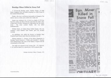
Newspaper - CENTRAL DEBORAH GOLD MINE MINING FATALITY
Newspaper article and typed copy of same, detailing the fatal accident that occurred at the mine on the 22nd January 1953, in which Herbert Hunter of Kangaroo Flat was killed. ' Hunter was working at No 16 level at a depth of 1270 feet from the surface and about 500 feet south from the shaft when a large piece of stone , estimated to wrigh about one ton, broke away. The stone crushed Hunter, who was killed instantaneously' Bendigo Advertiser article dated Friday 23rd January, 1953.bendigo, mining, central deborah gold mine -
 Bendigo Historical Society Inc.
Map - GEOLOGICAL MAP BENDIGO GOLD FIELD
Geological map Bendigo gold field. Showing anticlines, synclines, shafts, alluvial, contours. Produced by the deprtment of mines. Two originals plus two laminated copies -
 Bendigo Historical Society Inc.
Document - ALBERT RICHARDSON COLLECTION: CARLISLE UNITED MINE GARDEN GULLY LINE
... , 660 yards on line of reef. The Kent shaft was the next mine... with details of the Carlisle United Gold Mine at Long Gully. The lease ...Eight page handwritten document with details of the Carlisle United Gold Mine at Long Gully. The lease was 76 acres, 660 yards on line of reef. The Kent shaft was the next mine north Havilah Road, Boldt Street's corner. 'The Carlisle United was formed by the amalgamation of ttte companies, the Old Carlisle, the North Garden and the Passby. These mines were situated on the west side of Bennett Street in about a length of a few hundred feet, with the Passby on the Casley Street corner. And the old Carlisle and North Garden only recently being unearthed beneath the Unity, 'Carlisle' sand heap.' Details about the mining plant, the main shaft, the winding engine air compressor, stone crusher, and engine house are given. The Kent shaft and steel poppet legs are described. Four early claims on the Carlisle United ground are listed: Morgan, Kirshner and Co., Boyd and Co. Claim, Shanks and Co's claim and Day and Co's claim.bendigo, mining, carlisle united -
 Bendigo Historical Society Inc.
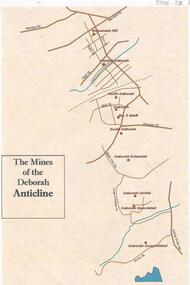
Document - THE MINES OF THE DEBORAH ANTICLINE
Plan of the mines along the Deborah Anticline: Deborah Consolidated, Deborah Associated, Deborah United, Deborah Extended, South Deborah, No. 2 shaft, Deborah North Deborah, Central Deborah, Monument Hill are all sited on the plan.Philip Wilkin, volunteer, BHSbendigo, mining, deborah line of reef -
 Bendigo Historical Society Inc.
Document - ALBERT RICHARDSON COLLECTION: HERCULES MINE REPORT 1936
a. four page handwritten report on the Hercules Mine, half yearly reports 1936. Extract: Reef worked below the 1620 feet level has been opened up at 1,840 feet. Profit has been earned but values are now unprofitable. At the Stanfield shaft, erection of plan was completed and shaft sunk to 344 feet. X cuts put out at 230 and 310 feet. Angus Mackay Chairman. b. Summary of sale of mine from Bendigo Advertiser 19.6.1950, handwritten by Albert Richardson, re the sale of the mining equipment at the Hercules Mine. ' Winding engines sold for £200 Compressor £425 and the oregon poppet legs for £41. The three main buildings went for £435 , the office and store room for £80, and die room for £12 Most spirited bidding was for 5 tons of firewood which finally went for £12Albert Richardsonbendigo, mining, hercules mine -
 Bendigo Historical Society Inc.
Document - ALBERT RICHARDSON COLLECTION: HERCULES AND ENERGETIC
One page handwritten document titled ' Hercules and Energetic, Mine Manager, J. Roberts Report, transcribed by Albert Richardson. Dates from 1910 to 1911. Extract from text: '30.6.1911, Carpenter has started to pull down the old poppet legs on east shaft'.Albert Richardsonbendigo, mining, hercules and energetic mine -
 Bendigo Historical Society Inc.
Document - ALBERT RICHARDSON COLLECTION: VICTORIA HILL MINES
Two page handwritten document titled 'Victoria Hill Mines, Dickers M.R. 23.11.1861. Wittschiebe and Co. Claim. Next north to No. 2, Midway Company' Transcribed by Albert Richardson. Extract from text: 'There are reefs passing through this ground at small intervals in every part of this claim, they all dip north. The mass of leaders struck in No. 4 (shaft) yielded, on an average about 1 1/2 ounces to the ton to the amount, in all, of about 12,000 pounds. From the eastern Victoria, the present proprietors extracted in nine months 55,000 pounds worth of gold.' Owners of mine. Messrs A. Witrtschiebe, A. Sagasser, F. Meison, A. Urban, H. Koch, C. Killian and A. Rudolf. Document details the claim, the shafts sunk, their depth, issues re workings and gold found.Albert Richardsonbendigo, mining, wittschiebe & co. claim -
 Bendigo Historical Society Inc.
Document - ALBERT RICHARDSON COLLECTION: WATTLE GULLY GOLD MINE, CHEWTON
One page document. On top of page 'Wattle Gully Mine, Chewton, Mining and Equipment' Document details the main shaft, concentrating plant, drainage water, compressed air and ventilation. Machinery mentioned: Ingersoll -Rand compressor; Ruston-Hornby diesel engine and Jaques jaw crusher.bendigo, mining, wattle gully gold mine chewton -
 Bendigo Historical Society Inc.
Document - ALBERT RICHARDSON COLLECTION: A 1 COMPANY
One page document detailing the formation of the A1 Mining Company in 28.8.1918. Company formed by Melbourne investors. Capital of 50,000 pounds in 100,000 shares at 10/- each. Included the Clarence, New Moon and Suffolk on the Garden Gully line. A1 purchased the winding plant at the New Moon and the winch plant at the Clark and Neanger shafts. Clarence, North Argus, Suffolk and New Moon south and east shafts remain the property of the companies.bendigo, mining, a1 gold mine -
 Bendigo Historical Society Inc.
Document - ALBERT RICHARDSON COLLECTION: COLLMAN AND TACCHI MINE
Seven page document with information on the Collman and Tacchi Gold Mine, from the Manager's report. R. Eddy Manager from 30.3.1905. Dates of information from 2.11.1902 to 1914, Example of information: Manager's Report 11.1.1912. 'Rope on south drum broke last Saturday, it broke about 100 feet from the surface when the cage was at 2100 feet. No damage done to cage or shaft. We have got the rope out of the shaft abnd started baling. Will have the water out and resume sinking the shaft Saturday morning. Cleaned and tested both boilers to 180 lbs to the square inch, also cleaned out the flues, overhauled the compressor and done all necessary repairs.'bendigo, mining, collman and tacchi mine -
 Bendigo Historical Society Inc.
Photograph - NORTH DEBORAH GOLD MINE POPPET HEAD
North Deborah Gold Mine steel poppet head, Breen Street, Golden Square. Image shows a steel poppet head, winding wheels on top with ore bins on right hand side. Not visible on top of poppet head are two air raid siren horns, installed during World War 2. Fig tree growing near shaft.Kay MacGregor 2012bendigo, mining, north deborah gold mine -
 Bendigo Historical Society Inc.
Document - ALBERT RICHARDSON COLLECTION: CARSHALTON LINE OF REEF
Five page handwritten document with: 1. details of the Carshalton line of reef and a photocopied extract from an book (not referenced) with information about the Carshalton Gold Mining Company NL 2. Some facts and figures and comments ( about Bendigo mines generally) topics include deep shafts, shafts made safe, men employed on field, cost of firewood, winding ropes - flat and round, size of mining shafts, weekly wages, 'years of pride' and 'years of destruction'. Signed by Albert Richardson, 29 Harrison Street, Bendigo.March 1968.bendigo, mining, carshalton reef line -
 Bendigo Historical Society Inc.
Document - ALBERT RICHARDSON COLLECTION: BIG DEBORAH GOLD MINE
... 15 page document, photocopied. A collection of mine... BENDIGO Mining big deborah gold mine 15 page document, photocopied ...15 page document, photocopied. A collection of mine managers' reports and Albert Richardson's research re the mine known as the 'Big Deborah' on the Deborah line of reef. Contains details of the engine house, the boilers, the winding engine, reconditioning the boilers, the poppet legs, shaft details and underground equipment. The poppet legs are steel and originally from the 'Windmill Hill' mine, Sebastian. The Big Deborah had a shaft depth of 2017 feet, the No. 2 shaft was 240 feet. Mine formed in 1932, ceased operations in 1959, located in Golden Square, near the railway line. Report on diamond drilling at North Deborah.bendigo, mining, big deborah gold mine -
 Bendigo Historical Society Inc.
Document - ALBERT RICHARDSON COLLECTION: NEW CHUM LINE OF REEF MINES
Five page document, handwritten, detailing the mines along the New Chum Line of Reef. A table of information is attached with data about the early workings on the reef line. Calls, dividends, ounces of gold extracted and depth of shafts are described.bendigo, mining, new chum line of reef -
 Bendigo Historical Society Inc.
Document - ALBERT RICHARDSON COLLECTION: EARLY HISTORY OF THE BENDIGO GOLDFIELD
Typed foolscap two sided document with information about the early history of the Bendigo Goldfield. Topics include the first gold discovery, how gullies were worked, quartz reefing, gold cakes, hand dollies and Chilian mills. Some brief statistics of the Bendigo goldfield include the total gold yield of 17,370,561 ounces plus 5,000,000 oz sold outside Bendigo. The greatest depth reached by any mine in the State, 4,593 feet below surface, or 3,700 feet below sea-level, was attained by the Victoria Quartz Company. About 100 shafts exceed a depth of 1,000 feet, of which 40 are between 2,000 and 3,000 feet deep, fifteen are between 3,000 and 4,000 feet and two are over 4,000 feet.bendigo, mining, mines department -
 Bendigo Historical Society Inc.
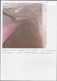
Photograph - KEN BICE COLLECTION: WATTLE GULLY GOLD MINE
Colour photograph, faded and laminated. Image shows an underground tunnel with air/electricity wiring on LH side of decline. Written on bottom : looking east towards main shaft. No. 1 level (60m) main xcut 1979. Bob Farrell in background'mining, underground equipment, wattle gully gold mine -
 Bendigo Historical Society Inc.
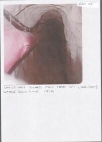
Photograph - KEN BICE COLLECTION: WATTLE GULLY GOLD MINE
Laminated, faded colour photograph. Image shows stope with air lines. On bottom of image: ' looking east towards main shaft No. 1 level, Wattle Gully Mine 1979'mining, equipment, wattle gully gold mine