Showing 22441 items
matching north
-
 Eltham District Historical Society Inc
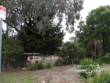
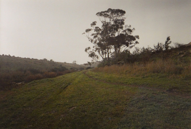
Photograph, Liz Pidgeon, Wattletree Road, Eltham North, 7 November 2017, 7 Nov 2017
13 born digital imageseltham north, eltham north primary school, wattletree pre-school, wattletree road bridge, wattletree road -
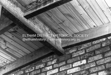
 Ballarat Heritage Services
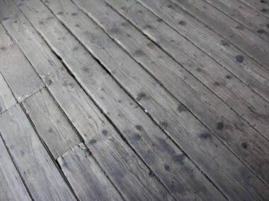
Photograph - Photograph - Colour, Timber Floor on the North Platform, Ballarat Railway Precinct, 2017
Colour photograph of fwell worn timber floor boards at the Ballarat Railway Station. ballarat railway station, floor boards -
 Whitehorse Historical Society Inc.
Photograph, Old Orchard Shopping Centre Blackburn North, 10/11/2010 12:00:00 AM
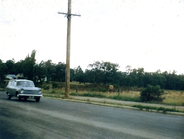
The Old Orchard Shopping Centre was completed by October 1965Coloured photograph of land on the eastern side of Springfield Road being cleared for the building of the Old Orchard Shopping Centre. Station wagon on left. Pole in centre.old orchard shopping centre, blackburn shopping centres -
 Ballarat Heritage Services
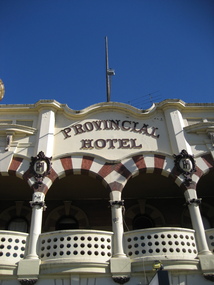
Photograph - Colour, Provincial Hotel, Lydiard Street North, Ballarat, 2015, 15/12/2015
Colour photograph of a detail of the facade of the Provincial Hotel in Ballarat.provincial hotel, hotels, ballarat -
 Ballarat Heritage Services
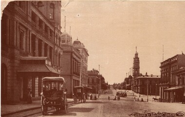
Photograph - Image, Lydiard Street Ballarat Looking North, C1890
Lydiard Street is a street in central Ballarat known for its Victorian architecture. The building with clock tower is the former Ballarat Post Office, the tower stage of the building dating from 1885. It sits on the corner of Sturt Street. Black and white photograph of Lydiard Street Ballarat.lydiard street ballarat, ballarat post office, tram, streetscape, architecture, vintage cars -
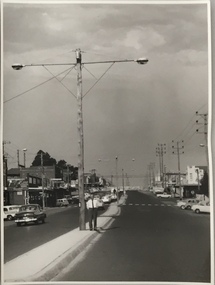
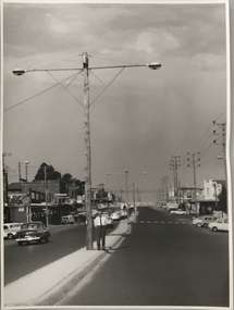
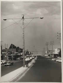
 Horsham Regional Art Gallery
Photograph, Mark STRIZIC, In North Melbourne, 1972 (printed 1989)
Donated through the Australian Government's Cultural Gifts Program by Dr Jonathan Hartley, 2006silver gelatin photograph -
 Ballarat Heritage Services
Photograph - Photograph - Colour, 10 Raglan Street North, Ballarat Central
Raglan Street is located within the heritage precinct of central Ballarat. This house was built around the turn of the century, with sewerage being added in 1908. The hallway is lined with pressed metal, the remainder of the metal being used at Talbot Hall. The building was occupied by Dr Pern.Postcard size colour photo of a weatherboard house in Raglan St Ballarat.raglan street, ballarat, house, garden, architecture -
 Eltham District Historical Society Inc
Photograph, Michael Wood, Wood family home post construction, 184 Progress Road, Eltham North, 1970
Black and white negative film, 120 format 6 x 6 black & white (no markings); 2 strips of 3 frames and 2 single framesalistair knox design, eltham north, houses, progress road -
 Eltham District Historical Society Inc
Photograph, Michael Wood, Wood family home during construction, 184 Progress Road, Eltham North, 1969
Wood family home (1969-2011) pre and post construction by Knox and HellemonsIlford FP3 35mm black and white negative film; 3 strips, 15 frames Also 10 x 12 cm black and white print of frame no. 25alistair knox design, construction, eltham north, hellemon, houses, progress road, car -
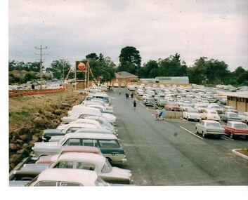 Whitehorse Historical Society Inc.
Photograph - Coloured Photograph, Old Orchard Shopping Centre, Blackburn North, 1965
Coloured photograph of cars parked along Springfield Road and in the car park of the Old Orchard Shopping Centre on opening day - October 1965old orchard shopping centre, blackburn shopping centres -
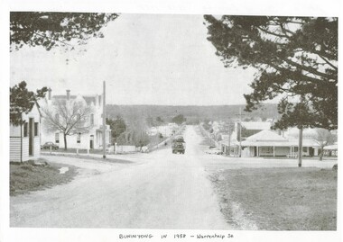 Buninyong & District Historical Society
Photograph - Photo of Original Photograph, Warrenheip / Learmonth intersection, looking north up Warrenheip, in 1958, 1995
historic streetscapeB/W photograph, Warrenheip / Learmonth intersection, looking north up Warrenheip, in 1958, Crown Hotel, corner store visible, truck with double layer load of cars heading north."Specially Produced For A.H. Dixon Learmonth St, from east, Buninyong 1543"buninyong, learmonth st., warrenheip st., intersection, crown hotel, corner store -
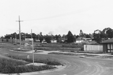 Ringwood and District Historical Society
Photograph, Westward view along Jull Road from corner of Carol Court, North Ringwood - 1981
Written on back of photograph, "E621. N3. 1981. Jull Road, North Ringwood from Carol Court looking towards Oban Road. North Ringwood sports ground centre left". -
 Kew Historical Society Inc
Photograph, Stuart Tompkins Studio, Electricity Supply Poles, North Road, Ormond, 1965
Research provided by Stuart Tompkins Studio, Box Hill, into alternatives for median strip street lighting to be used in Burke Road, Kew. The photographers identified variants in different suburbs appropriate to Kew's needs.The series from which the photograph is drawn provides a snapshot by a commercial photographic studio of each named vicinity in 1965 as well as providing examples of public works infrastructure being commissioned by local government in the 1960s. The photos originally formed part of the Engineering Department's files in the City of Kew before being donated to the kew Historical Society.Electricity Supply Poles, North Road, Ormond, 1965. Electricity supply poles photographed for the Kew City Council by Stuart Tompkins Studio. The photograph of North Road, Ormond west of Jasper Road, looking east depicts wooden poles carrying two lamps in a median strip and with two on each side alternately. It was noted that the supply wires were from one side only. The poles were described as 3′ above ground and 11.25″ in diameter. The plan was to use this approach for Burke Road, Kew. [There are three copies of this photograph in the Collection.] Typed inscription on reverse: "Electricity Supply Poles. Photographed for Kew City Council 8/2/65. No.1 North Road - Ormond, west of Jasper Road, looking east. Wooden poles carrying two lamps in median strip and two on each side alternately just as is proposed for Burke Road, Kew. Supply wires from one side only. Poles 3' above ground 11 1/4" dia." Studio stamp: "Stuart Tompkins Studio. 547 Station Street, Box Hill. WX1439."stuart tompkins studio, street lighting, south road (moorabin) 1965, public infrastructure -- city of kew, city of kew -- engineer's department -
 Kew Historical Society Inc
Photograph, Stuart Tompkins Studio, Electricity Supply Poles, North Road, Ormond, 1965
Research provided by Stuart Tompkins Studio, Box Hill, into alternatives for median strip street lighting to be used in Burke Road, Kew. The photographers identified variants in different suburbs appropriate to Kew's needs.The series from which the photograph is drawn provides a snapshot by a commercial photographic studio of each named vicinity in 1965 as well as providing examples of public works infrastructure being commissioned by local government in the 1960s. The photos originally formed part of the Engineering Department's files in the City of Kew before being donated to the kew Historical Society.Electricity Supply Poles, North Road, Ormond, 1965. Electricity supply poles photographed for the Kew City Council by Stuart Tompkins Studio. The photograph of North Road, Ormond west of Jasper Road, looking east depicts wooden poles carrying two lamps in a median strip and with two on each side alternately. It was noted that the supply wires were from one side only. The poles were described as 3′ above ground and 11.25″ in diameter. The plan was to use this approach for Burke Road, Kew. [There are three copies of this photograph in the Collection.] Typed inscription on reverse: "Electricity Supply Poles. Photographed for Kew City Council 8/2/65. No.1 North Road - Ormond, west of Jasper Road, looking east. Wooden poles carrying two lamps in median strip and two on each side alternately just as is proposed for Burke Road, Kew. Supply wires from one side only. Poles 3' above ground 11 1/4" dia." Studio stamp: "Stuart Tompkins Studio. 547 Station Street, Box Hill. WX1439."stuart tompkins studio, street lighting, south road (moorabin) 1965 -
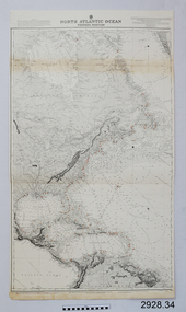 Flagstaff Hill Maritime Museum and Village
Document - Navigation Chart, North Atlantic Ocean, Western Portion
British Admiralty Navigation Chart - North Atlantic Ocean - Western Portionwarrnambool, shipwrecked-coast, flagstaff-hill, flagstaff-hill-maritime-museum, maritime-museum, shipwreck-coast, flagstaff-hill-maritime-village, shipwrecked-artefact, navigation chart, british admiralty navigation chart, british admiralty, north atlantic ocean -
 Brimbank City Council Art Collection
Photograph, Robert Pointon, East bank of the Kororoit Creed looking North, Deer Park, 1988
Local SceneDeer Park looking North up the river - Kororoit Creek - AR0021 -
 Kew Historical Society Inc
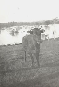
Photograph, Cattle in North Kew floods, 1934
The year 1934 witnessed the greatest flooding of the Yarra River since settlement. This work forms part of the collection assembled by the historian Dorothy Rogers, that was donated to the Kew Historical Society by her son John Rogers in 2015. The manuscripts, photographs, maps, and documents were sourced by her from both family and local collections or produced as references for her print publications. Many were directly used by Rogers in writing ‘Lovely Old Homes of Kew’ (1961) and 'A History of Kew' (1973), or the numerous articles on local history that she produced for suburban newspapers. Most of the photographs in the collection include detailed annotations in her hand. The Rogers Collection provides a comprehensive insight into the working habits of a historian in the 1960s and 1970s. Together it forms the largest privately-donated collection within the archives of the Kew Historical Society.Photograph of floodwaters encroaching on farm land in North Kew in the flood of 1934.Nth. Kew. 1934 Floodsfloods (melbourne) 1934, dorothy rogers -
 Kew Historical Society Inc
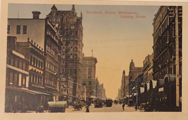
Postcard, Elizabeth Street, Melbourne, Looking North, 1920-1940
Collection of thirty-nine postcards donated by Jillian Rigby which had been owned by her grandparents, George and Edith Weir, who from c.1917 lived at 84 Princess Street, Kew. The mostly 'mint' postcards were purchased in Victoria and while travelling overseas. The sole dated postcard is dated from 1929. The postcards are numbered sequentially from 2017.0058.01-39. The remainder of the collection donated by Jill Rigby which was once owned by the Weirs of Broken Hill and Kew consist of costumes, costume accessories, photographs, and documents.The postcards in the Weir collection, especially those purchased on a trip or trips to the mother country, i.e. United Kingdom, represent a representative sample of sites that were considered significant to those Australians undertaking a reverse grand tour by member of the erstwhile colonies. Those postcards which are early views of Melbourne must have been produced commercially for some decades from the early part of the 20th century.Elizabeth Street, Melbourne, looking north. Coloured postcard. Weir collection."Kew Historical Society Inc"postcards, george and edith weir, elizabeth street - melbourne, weir collection -
 Kew Historical Society Inc
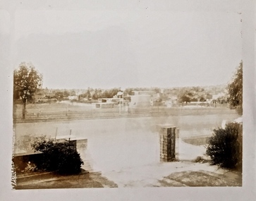
Photograph, Floods in North Kew, 1934
Living with natural processes was frequently a challenge to early European settlers and later residents of what was in the 1850s administered by the Borondara Road Board. This was compounded by the area being bounded on three sides by rivers (Yarra River, Koonung Creek and Gardiner's Creek). In 1849, the historian James Bonwick recorded that "our district [Kew] suffered considerably. Mr Wade speaks of 80 acres, out of 100 acres of his cultivated paddock, covered by water." Newspapers continued to describe major flooding in Kew in 1863, 1869, 1878, 1880, 1889, 1891, 1916 and 1934. While the construction of the Upper Yarra dam in 1957 reduced the levels of flowing downstream, local and riverine floods continue.The Kew Historical Society's pictures and map collections testify to the impact of flooding in the district. They have historical importance in documenting the extent of flooding in the district and its affects on homes, services and recreation. Numerous photographs record flooding throughout the Twentieth Century.Floods in North Kew, 1934. Chipperfield's Boat House under flood.floods (kew) 1934, yarra river, chipperfield's boat house -
 Kew Historical Society Inc
Photograph, Floods, North Kew, 1923
Floods in North Kew in the vicinity of Willsmere Park, donated by Kerry Woollard.floods (kew), yarra river -
 Whitehorse Historical Society Inc.
Book, Nunawading North neighbourhood Centre, 1983
Articles about the Blackburn North Neighbourhood Centre, presented by Phill Slattery.Articles about the Blackburn North Neighbourhood Centre, presented by Phill Slattery.Articles about the Blackburn North Neighbourhood Centre, presented by Phill Slattery.mountainview road, nunawading, no. 25, nunawading north neighbourhood centre -
Whitehorse Historical Society Inc.
Document, St Alfred's Anglican Church, Blackburn North, History, 12/12/1983 12:00:00 AM
History of St Alfred's Anglican Church, North Blackburn from 1962.History of St Alfred's Anglican Church, North Blackburn from 1962.History of St Alfred's Anglican Church, North Blackburn from 1962.st alfred's anglican church, blackburn north, shepherd, h (rev), sells, graeme a (rev) -
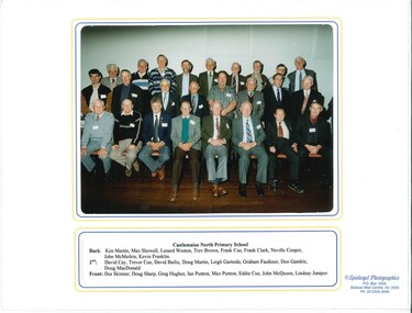 Old Castlemaine Schoolboys Association Inc.
Photograph, Past Pupils Castlemaine North PS 2001, 13/10/2001
photograph Containing Past pupils of Castlemaine North School at reunion in 2001 -
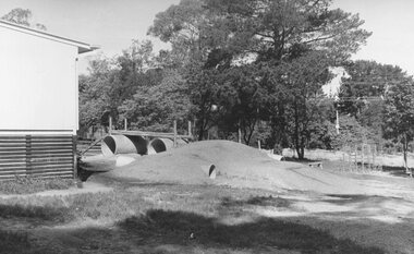 Ringwood and District Historical Society
Photograph, Adventure playground additions to North Ringwood State School, Oban Road, 1973
Written on backing sheet, "North Ringwood State School Adventure playground - 1973". -
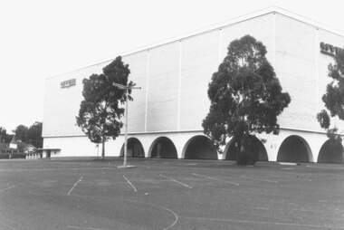 Ringwood and District Historical Society
Photograph, North west corner of Eastland 1987
Written on back of photograph, "14/2/87. North west corner of Eastland." -
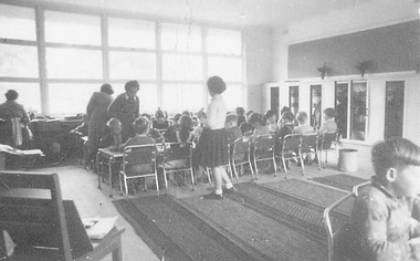 Ringwood and District Historical Society
Photograph, Undated photograph captioned "North Ringwood State School - New room"
Written on back of photograph, "North Ringwood State School - New room". [No date] -
 Ringwood and District Historical Society
Photograph, North Ringwood State School - 20/10/73
Written on back of photograph, "North Ringwood State School - 20/10/73". -
 Ringwood and District Historical Society
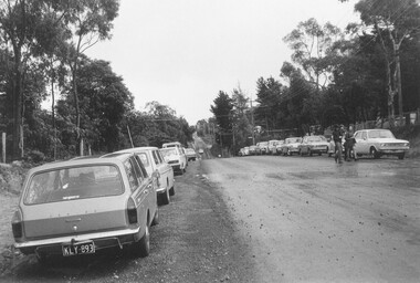
Photograph, Old Level Crossing, Ringwood, looking North with Webdales Licensed Grocers. Mid 1976
Also Webdales Licensed Grocer StoreWritten on back of photograph, "Old level crossing looking north. Mid 1976". -
 Stawell Historical Society Inc
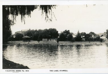
Photograph, Cato Lake looking North Pre c 1930 -- Postcard
Post Card Valentine Series pre 1930. "The Lake" Stawell. The lake has been renamed and now called Cato Lake. This view is looking north and shows distant buildings of Stawell behind a line of trees. People can be seen enjoying the lake walking and swimming with a rotunda between the trees and the lake. Valentine Series post card of The Lake, Stawell looking north pre 1930's. The back of the Coffee Palace can be seen on the left back and the roof of the Anglican church can be seen above the trees. The other side to the right are houses in Florence Street. Along the lake are people walking and enjoying the waters edge swimming. A rotunda is to the left and the post card is framed by an overhanging willow tree. Valentine Series No 1814 The Lake, Stawell. Valentine Publishing Co. Melbourne & Sydney.stawell