Showing 1887 items
matching north rd
-
 Eltham District Historical Society Inc
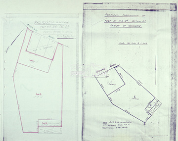
Slide - Photograph, Eltham Shire Council, Plan of Subdivision, Crown Allotment 8, Section 8A, Parish of Nillumbik,County of Evelyn, 1969
35mm colour positive transparency blue Agfacolour Service plastic mountC1, Pain, Sibbel and Carter, Research-Warrandyte Road, North Warrandyte, 4 August 1969carter, infrastructure, map, north warrandyte, pain, parish of nillumbik, plan of subdivision, planning, research-warrandyte road, sibbel, subdivison lots -
 Eltham District Historical Society Inc
Slide - Photograph, Eltham Shire Council, Proposed subdivision of Part of Crown Allotment 8B, Section 8A, Parish of Nillumbik, 1969
35mm colour positive transparency blue Agfacolour Service plastic mountE4, N0424, Stock subdivision, North Warrandyte, 4 August 1969infrastructure, map, planning, subdivison lots -
 Eltham District Historical Society Inc
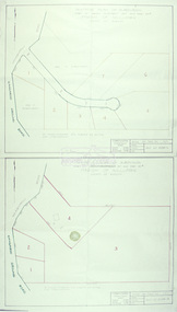
Slide - Photograph, Eltham Shire Council, Tentative Plan of Subdivision, Part of Crown Allotment 20A and Part 20B, Parish of Nillumbik, County of Evelyn, 1969
35mm colour positive transparency blue Agfacolour Service plastic mountE2, N899, Young subdivision, Kangaroo Ground-Warrandyte Road, North Warrandyte, 4 August 1969infrastructure, map, planning, subdivison lots, kangaroo ground-warrandyte road, north warrandyte -
 Eltham District Historical Society Inc
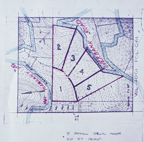
Slide - Photograph, Eltham Shire Council, Proposed subdivision of five approximately equal areas of 5 acres, Vol. 4061, Fol. 061, Overbank Road, North Warrandyte, 1969
35mm colour positive transparency blue Agfacolour Service plastic mountD4, 55341, Peck subdivision, Mount Pleasant Road, 4 August 1969infrastructure, map, planning, subdivison lots, overbank road, mount pleasant road, north warrandyte -
 Eltham District Historical Society Inc
Slide - Photograph, Eltham Shire Council, Unidentified street, possibly Montmorency or Eltham North, c.Oct. 1980
... Eltham District Historical Society Inc 728 Main Rd Eltham ...35mm colour positive transparency (1 of 24) Mount - Kodak Kodachrome Cardeltham north, houses, infrastructure, roads, montmorency, unidentified -
 Eltham District Historical Society Inc
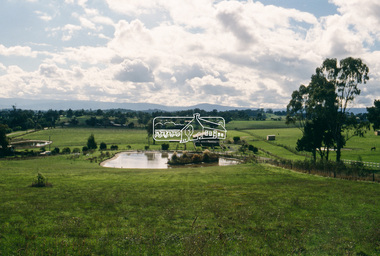
Slide - Photograph, North Riding Mudbrick Restaurant, St Andrews, c.May 1988
35mm colour positive transparency (1 of 25) Mount - Kodak EktachromeProcess Date MAY 88Mst andrews, north riding mudbrick restaurant -
 Eltham District Historical Society Inc
Slide - Photograph, Kangaroo Ground, possibly looking north from Henley Road, c.May 1988
35mm colour positive transparency (1 of 25) Mount - Kodak EktachromeProcess Date MAY 88Mhenley road, kangaroo ground -
 Eltham District Historical Society Inc
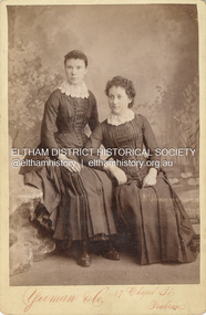
Photograph, Possibly Caroline Shillinglaw on left and sister Margaret Shillinglaw, c.1884
Caroline Shillinglaw was born at Plenty, October 6, 1863. She died at the Shillinglaw family cottage 'Wattle Brae' in Eltham April 11, 1947. Caroline never married and was the youngest of Phillip Shillinglaw's siblings. Margaret Shillinglaw was William and Jean Shillinglaw's ninth child. She was born at Northcote March 3, 1856 and died at North Fitzroy September 7, 1933. She never married. Yeoman & Co operated at 47 Chapel St., Prahran from 1883 to 1889. The fashion depicted is typical of mid 1880s. CABINET 1866-1905 The Cabinet photo was introduced in 1866 in answer to a demand for a larger format photograph which could be mounted for a cabinet or on the wall. They were 4.5 inches by 6.5 inches (11.5 x 16.5 cm), more than twice the size of the cdv. They cost about twice as much as a cdv but eventually displaced them. They were not extensively produced until 1880 and had ceased by 1905. Coloured mounts, especially maroon or green, indicate a date between 1880 and 1890. - Frost, Lenore; Dating Family Photos 1850-1920; Valiant Press Pty. Ltd., Berwick, Victoria 1991cabinet photo, marg ball collection, shillinglaw family photo album 3, 1883-1889, 1884, caroline shillinglaw (1863-1947), margaret shillinglaw (1856-1933), unknown, yeoman & co photographer 47 chapel st prahran -
 Eltham District Historical Society Inc
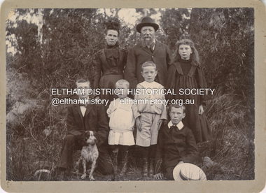
Photograph, Nicholes Photographers, Bird family, c.1905
Bird family, c.1905 Back row, L-R: Janet Bird (nee Kilpatrick), George Bird, Ellen May (Nell) Bird Front row L-R: George Hugh Bird, Ernest Reginald Bird, Arthur Andrew Bird, Edwin John Bird Nicholes Photographer, Alphington According to the Sands McDougall Melbourne Directory, George. Nicholes, Photographer was first listed on the north side of Heidelberg Road, Alphington in 1904 and again in 1905. By 1906 he was still listed but with no profession. From 1907 on he was listed as a bicycle agent. On July 23, 1878, George Bird married Janet Kilpatrick (born Ayrshire) at Northcote by Presbyterian minister, Duncan Fraser. The witnesses were daughters of the minister. George gave his profession as farmer. Around 1880 or possibly earlier he acquired the property known as View Hill at the top of Pitt Street, Eltham between Pitt Street and Mount Pleasant Road and what is now Eucalyptus Road. George and Janet developed an orchard and farm around the View Hill home and had 10 children, three of whom died young. George Bird is listed in the 1977 history of the Eltham Methodist Church as Steward and trustee in the early years. In the 1950 history he is mentioned as Sunday School Superintendent. In the early 1900s, Janet regularly went to the church by horse and jinker. Janet died September 2, 1915, age 60 of endocarditis and bronchial pneumonia. At about this time, three children had married (Sarah, George and Ada) and four were living at home. However, Edwin joined the AIF in August 1915 and Ellen married in 1916 leaving two sons, Arthur and Reg, to look after their father and the property although some of the married children may have lived at View Hill for some time. From Edwin's letters, Hilda Pepper, a cousin on their mother's side) stayed with the family for some time to help. In later years, George developed glaucoma and became blind. He died December 6, 1920, aged 75 years, of diabetes mellites. Both Janet and George are buried at Eltham Cemetery, but the gravestone incorrectly gives 1921 for the death of George. The estate was divided into equal portions and distributed to the surviving members with Arthur and Ted Pepper being Executors. Ada Janet Lowe received a portion above what is now Rockliffe Street and Sis Pepper (Sarah Ann nee Bird) the portion below Rockliffe Street. Ernest Pepper built in the 1930s on the Pepper block at the Pitt Street end. George's share was along Wattle Grove and Arthur received the portion at the eastern end. Presumably the other two received portions including the top of the hill and slopes down to Pitt Street, Mount Pleasant Road and Wattle Grove. Read's (at the corner of Pitt Street and View Hill Crescent) was the first additional house brought in on wheels by a Mr Walkenden. The View Hill house was occupied by the Johanssons in the 1930s and was later damaged by fire. Source: Info provided to Marg Ball by Neil and Lyn Pepper (both deceased) abt. 2018. PANEL 1875-1920 Panels began to be produced around 1875, and were particularly suited, because of their larger size, for capturing family, or even larger, groups. They measured 8.5 by 6.5 inches (22 cm x 16.5 cm). - Frost, Lenore; Dating Family Photos 1850-1920; Valiant Press Pty. Ltd., Berwick, Victoria 1991marg ball collection, 1905, arthur andrew bird, bird family, edwin john bird, ellen may (nell) bird, ernest reginald bird, george bird (1845-1921), george hugh bird, janet bird (nee kilpatrick), nicholes photographer alphington, straw boater -
 Eltham District Historical Society Inc
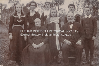
Photograph, Nicholes Photorgraphers, Phillip Shillinglaw with his mother and children, c.1905
Standing: Florence May Shillinglaw (1886-1969), Elizabeth (Lizzie) Ann Shillinglaw (1879-1972), Mary Ann Shillinglaw (1880-1963), Ada Maria Shillinglaw (1889-1974), Caroline (Carrie) Shillinglaw (1876-1956), Ernest Samuel Shillinglaw (1888-1958) Seated: Jean Shillinglaw (nee Blemner 1819-1906), Phillip Shillinglaw (1842-1914) Nicholes Photographer, Alphington According to the Sands McDougall Melbourne Directory, George. Nicholes, Photographer was first listed on the north side of Heidelberg Road, Alphington in 1904 and again in 1905. By 1906 he was still listed but with no profession. From 1907 on he was listed as a bicycle agent. PANEL 1875-1920 Panels began to be produced around 1875, and were particularly suited, because of their larger size, for capturing family, or even larger, groups. They measured 8.5 by 6.5 inches (22 cm x 16.5 cm). - Frost, Lenore; Dating Family Photos 1850-1920; Valiant Press Pty. Ltd., Berwick, Victoria 1991marg ball collection, 1905, 1904-1905, ada maria chrisfield (nee shillinglaw) 1889-1974, ada maria shillinglaw (1889-1974), caroline (carrie) watson (nee shillinglaw) 1876-1956, elizabeth (lizzie) ann shillinglaw (1879-1972), ernest samuel shillinglaw (1888-1958), florence may bunker (nee shillinglaw) (1886-1969), jean shillinglaw (nee blemner 1819-1906), mary ann shillinglaw (1880-1963), nicholes photographer alphington, phillip shillinglaw (1842-1914) -
 Eltham District Historical Society Inc
Photograph - Aerial Photograph, Landata, Eltham, Main Road; Mt Pleasant Rd to Railway Rd, Dec. 1945
Centred on Main Rd and Henry St, Eltham bounded by Railway Road to north, Mount Pleasant Road at Main Road to south, top of the hill in Arthur Street to east and Karingal Drive at Sherbourne Road to west. Historic Aerial Imagery Source: Landata.vic.gov.au Aerial Photo Details: Project No :65 Project : MELBOURNE AND METROPOLITAN PROJECT NO. 2 Run : 8 Frame : 70 Date : 01/1951 Film Type : B/W Camera : EAG9 Flying Height : 12200 Scale : 12000 Film Number : 1419 GDA2020 : 37°43'06"S, 145°08'45"E MGA2020 : 336589, 5823811 (55) Melways : 21 J6 (ed. 42)aerial photo, eltham, main road, henry street, arthur street, bolton street, eltham-yarra glen road, neil webster collection, 1951-01, dave lyon house, ernie andrew house, karingal road, melway 21j6, mount pleasant road, railway road -
 Eltham District Historical Society Inc
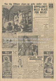
Newspaper - News Clipping, Herald, The big Eltham clean-up gets under way, Herald, 4 March, p3, 1965
Full page newspaper clipping featuring the March 1965 Victorian bushfires. Items include: Photograph - TWO-WOMAN BUCKET BRIGADE, Mrs Henry Marsden (left) and Mrs Moureen Ellis, whose fire-fighting efforts yesterday were highly praised today by their Eltham neighbours, carry out mopping-up operations Photograph - DOGS MADE HOMELESS by the fire in North Eltham yesterday are being cared for at First-Constable Doug. Mummery's kennels at Eltham and here is kennel maid Helen Oliver, 17, with some of them today. The two basset hounds are owned by Mr Bill Guy who lost about 100 daschund and basset hound puppies and dogs in the fire. Photograph - He died at Eltham [Picture of John Lawrence Coleman] Builder Mr John Lawrence Coleman, 31, of Main Rd., Eltham, one of three men burnt to death yesterday in the fire at North Eltham. The other two were XXXXX, 33 who lives opposite the Colemans and Mr William Elwers, 64 of Batman Rd., Eltham. John Lawrence Coleman (1934-1965) born January 10, was the son of Raymond John Coleman and Hanna May (Gillet) Coleman. He married Margaret Frances Dare in 1955 and was the father of two children. He died whilst attempting to rescue an older man trapped in the bushfire at North Eltham on March 3, 1965 Other news stories of the day: Bushfires rage in Victoria, Snowy: Three dead (1965, March 4). The Canberra Times (ACT : 1926 - 1995), p. 1. Retrieved May 19, 2022, from http://nla.gov.au/nla.news-article131758981 Includes two photos of the fire in North Eltham “Firemen make for safety as fire rages in Upper Glen Park Road, North Eltham, Victoria. The smoke hides a house.” and “A house explodes into flames at North Eltham, Victoria. Firemen said bottled gas went up.” Canberra Times (ACT : 1926 - 1995), Thursday 4 March 1965, page 1 ________________________________________ Firemen make for safety as fire rages in Upper Glen Park Road. North Eltham. Victoria. The smoke hides a house. A house explodes into flames at North Eltham. Victoria. Firemen said bottled gas went up. Bushfires rage in Victoria, Snowy: Three dead MELBOURNE, Wednesday.—Three people died today in a bush» fire which raged through North Eltham, about 15 miles from Melbourne. The victims were three men. A fourth man is feared to be dead. Another bushfire. sparked off by the heatwave sizzling over south-eastern Australia, is burning out of control in the Kosciusko State Park, in the Snowy Mountains. Firefighters fear that if it reaches pine forests up the Yarrangobilly River, they will be powerless to stop it. The three victims of the North Eltbam fire were trapped by flames in a valley. Their bodies were found only a few yards apart. They were named by police tonight as Mr. George Crowe, 78, of North Eltham, William John Ewers, 64, and John Laurence Coleman, 31, both of Eltham. The other two have not been identified. They are believed to be a man aged about 40 and an 18-year-old youth. At least 12 homes were destroyed by the fire, the worst in Victoria since 1962, when eight lives were lost and hundreds of homes burnt down at Warrandyte. At one time the township of Eltham was threatened, but a cool change swept in from the south and held back the wall of flames. More than 100 dogs, worth about £4,000, died when the fire raced through two kennels in Short Street, Eltham. and Upper Glen Park Road, North Eltham. A trickle of water Residents ran into the streets as the blaze raced towards their houses. Others frantically dug firebreaks around their homes. Mrs. Sue Recourt wept when firemen arrived while she was vainly trying to stop the flames with a trickle of water from the garden hose. A stack of firewood was blazing, but the firemen managed to save the house and rescue four goats. Many homes in Eltham were saved after flames had crept to within feet of their fences. Students at North Eltham State School had to be evacuated when the blaze threatened the building. Fire fighters were severely hampered by lack of water and narrow roads. The blaze, which began in above century heat, turned toward Wattle Glen, where two houses were gutted. Then the flames raced towards Hurstbridge to the north. Firemen battling desperately, controlled the fire late this afternoon. Five forest fires were still burning in Victoria tonight. IN VICTORIA THIS WEEK Tragic lack of central fire authority (1965, March 9). The Canberra Times (ACT : 1926 - 1995), p. 2. Retrieved May 19, 2022, from http://nla.gov.au/nla.news-article131759928 Canberra Times (ACT : 1926 - 1995), Tuesday 9 March 1965, page 2 ________________________________________ IN VICTORIA THIS WEEK Tragic lack of central fire authority From Rohan Rivett It was the worst week for Victorian fire fighters since Black Friday 27 years ago. On that day one pilot up in a spotter plane said afterwards: "It seemed at times that half the State was on fire." This time, for three days on end, Gippsland men, women and children had moments of conviction that their towns would have blackened into anonymity before the weekend was out. The week began with horror at Eltham on the North-eastern edge of Melbourne. Eltham today is something of an artists' colony. Oil painters, water colourists, potters and sculptors proliferate. A number of University folk have emulated the example of Professor MacMahon Ball who pioneered the way by moving to Eltham and carving a home out of the bush in the thirties. Innermost Eltham is barely 14 miles from the G.P.O. Farthest Eltham stretches miles beyond. It served to illustrate the tragi-ludicrous truncation of Victoria's fire control. Part of Eltham is under the protection of the Melbourne Fire Brigade. But this responsibility ceases at some invisible and incomprehensible line — apparently determined by the meanderings of the water mains. At this point everybody's property throughout the rest of Eltham is dependent on the Country Fire Authority. Half an hour before midday on Wednesday, a fire suddenly started on the West side of Upper Glen road on the edge of Eltham. Before the fire brigade could arrive, it was burning on a widening front through timber and high grass north of Eltham. Two wind changes in rapid succession saw the fire leaping Diamond Creek. With a freshening wind it struck home after home in three streets. More than one of them exploded suddenly as if hit by an incendiary bomb. There is no piped gas in the Eltham area, hence many housewives use bottle gas. The flames outside caused the bottles to explode. Altogether twelve homes were completely incinerated and four more were badly damaged. Thirty prize dogs perished. About three hours after the fire started it raced suddenly down a gully hillside trapping an elderly man. Two other men apparently raced to the rescue. Flames caught the three men within yards of each other, not 200 yards off the Upper Glen Park Road where safety lay. They were burned to death. Next evening an angry and convincing secretary of the Fire Brigade Union, Mr. W. M. Webber, came on television and appealed to the people of Victoria to end the ridiculous and dangerous dualism in fire-fighting control. The Eltham fire, he said, had precisely illustrated the situation. The Metropolitan Fire Brigade area touched Eltham, but where the fire had gutted and killed, was just outside its area. Mr. Webber said his union had constantly urged one authority for the State with a complete reorganisation of fire protection. On Wednesday the union had repeated its call for an inquiry into fire protection in Victoria to the Chief Secretary, Mr Rylah. "No matter how close the liaison between the two organisations, there are always divided sections of thinking," Mr. Webber told viewers. "I don't know how much tragedy the com-munity can take before it demands that it is properly protected." Rumours that differences in gauge between taps and hose nozzles (as between the two authorities) accentuated the damage were denied by fire chiefs who said that all appliances were now carrying adaptors so that hoses could be linked to mains everywhere. But there is grave concern in the Metropolitan Fire Brigade's higher councils at the action of several Federal authorities with projects in and around Melbourne. They are installing non-standard equipment without reference to the State authorities or any dovetailing of appliances and equipment. Public alarm was not diminished by the publication on Friday and Saturday of a heart tearing letter from the young widow of John Lawrence Coleman, 31 year old father of two, who had died in the flames apparently trying to rescue the old man trapped in the gully. By that time, a Vast area of Gippsland was in flames and the troops had been sent in to back up the overworked and often helpless fire-fighters. By Saturday, the Leader of the Opposition, Mr. Stoneham, who has previously demanded a Royal Commission into fire-fighting arrangements, repeated his demand. To add to the Chief Secretary's worries he was publicly rebuked for allegedly implying on television that lives had been lost at Eltham because people went to the wrong place at the wrong time. In a letter to the Press, Professor MacMahon Ball pointed out that two of the men involved were experienced bushmen who had gone "to help an old man in great danger fully aware of the danger to themselves". As Victoria faced its sixth day of total State-wide fire ban, it looked likely that even official resistance was not going to silence the demand for one central authority to control the fire fiend. At the moment, the 400 square miles where two million Victorians live in Greater Melbourne are divorced from the rest of the State in planning, communications, equipment and control of personnel. No one doubts the whole-hearted co-operation and willingness to back each other up of the M.F.B. and the C.F.A., both at top-level and among the firemen themselves. However, when a city straggles so deeply into the country side, the absence of a single authority, to oversee and analyse the fire threat as a whole, suggests suicidal policy of divide and fuel. Emphasis of the tragic loss of a member of a pioneering family who died whilst helping others in his communitybushfire, cfa, country fire authority, fire brigrade, glen park road, heroes, john lawrence coleman, north eltham, victorian bushfires - 1965, volunteers, william john elwers, fire fighter, frank martin, george john crowe, ken gaston, orchard avenue, doug mummery, helen oliver, mrs henry marsden, mrs moureen ellis -
 Eltham District Historical Society Inc
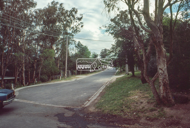
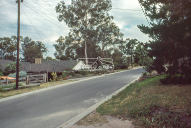
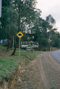
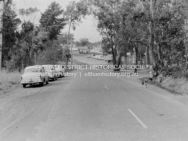
Photograph, Barry Philp, Eltham-Yarra Glen Road, Research, Vic, c.1967
View looking north along Eltham-Yarra Glen Road towards intersection with Research-Warrandyte Road and Research shops, c.1967. Three cars on the left, two FC Holden sedans (1958-1960) and a Holden HD Station Sedan (1965-1966)In digital metadata "My beautiful picture"cars, eltham-yarra glen road, holden fc, holden hd, main road, research (vic.), research shops, research-warrandyte road -
 Eltham District Historical Society Inc
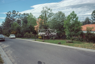
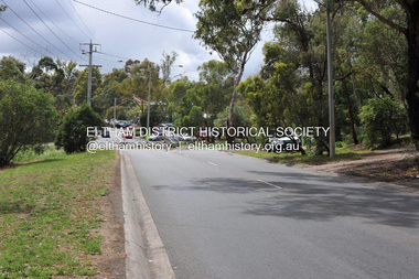
Photograph, Barry Philp, Eltham-Yarra Glen Road, Research, Vic, c.2013
View looking north along Eltham-Yarra Glen Road towards intersection with Research-Warrandyte Road and Research shops, c.2013eltham-yarra glen road, main road, research (vic.), research shops, research-warrandyte road -
 Eltham District Historical Society Inc
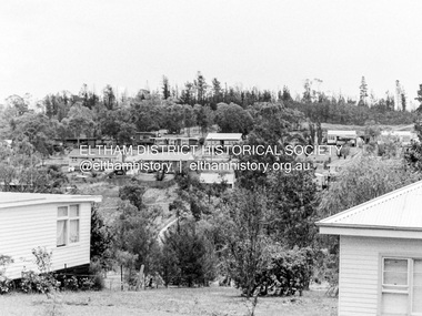
Photograph, Barry Philp, Looking north from Main Road to Storey Avenue, Research, c.1969
Taken from Main Road looking north to the houses in Storey Avenue and the Maroondah Aqueduct. From the appearance of the pine trees along the aqueduct it was taken just after the 1968-1969 fire.research (vic.), bushfires, main road, maroondah aqueduct, pine trees, storey avenue, victorian bushfires - 1969 -
 Eltham District Historical Society Inc
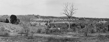
Photograph, Barry Philp, Looking north from the top of the hill near Reynolds Road, Research, c.1969
Taken from the top of the hill near Reynolds road looking north. The footy ground is visible behind the dead tree.research (vic.), research oval, reynolds road -
 Eltham District Historical Society Inc
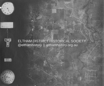
Photograph - Aerial Photograph, Landata, Eltham and Eltham North, Nov. 1931
Centred over present-day Opal Court and Manning Road, Eltham North Historic Aerial Imagery Source: Landata.vic.gov.au Aerial Photo Details: Project No :1931 Project : MALDON PRISON Run : 19 Frame : 3131 Date : 11/1931 Film Type : B/W Camera : F8 Flying Height : 11000 Scale : 18860 Film Number : 60 GDA2020 : 37°42'10"S, 145°08'07"E MGA2020 : 335621, 5825531 (55) Melways : 21 G2 (ed. 42)aerial photo, eltham, neil webster collection, eltham north, manning road, opal court -
 Glen Eira Historical Society
Book - St John's Anglican Church Bentleigh
1/The First Hundred Years 1854-1954 by Nancy Taylor (32 pages). A photocopy of the original. Brief history including St Stephens historical background. Bibliography and list of gifts. Two black and white photos of church circ 1890 and 1954 2/A Branch of the Vine, 150 Years of Christian Service in the Community by AJ Davis. Book of church and local history (2 copies).smith hr, st andrews, st johns east brighton, st john's anglican church east brighton, st john's church of england, st john's anglican church bentleigh, st lukes, north brighton, bentleigh, taylor nancy, fleming wi, romanis je, franklin jw, perry charles 1848, epstein june, green ih, raymond c hedley, oxford university press, st marks, landcox street, christchurch, ormond, saunders gr, bullocks ajs, simmonds sj, su, parker ecc, oliver ha, green lc, bullocks sh, vickery ls, fleming wi -
Glen Eira Historical Society
Document - St John's Anglican Church Bentleigh
Typed A4 sheet with details of a Great Wurlitzer organ and its history. Notes by Mr Sinclair. The Wurlitzer was moved to St Luke's, Carrum Downs when St John's obtained a recently restored organ from St Luke's, North Brighton in 1992.sinclair mr, organs -
Glen Eira Historical Society
Letter - St. Stephen’s Presbyterian Church, Caulfield
Two documents regarding the historical significance of St. Stephen’s Church, 158 Balaclava Road Caulfield. The first document is correspondence dated 25/09/1990 from the National Trust informing the City of Caulfield of the inclusion of the church on the National Trust Register. The second document is a photocopy of the Caulfield Conservation Study by Andrew Ward dated February 1994. It includes an unclear front view photograph, references and recommends planning scheme control.city of caulfield, caulfield, caulfield north, balaclava road, kooyong road, st. stephen’s church, presbyterian church, uniting church, ward andrew, kinross george, currie george, haddon robert, architects, builders, churches, caulfield conservation study, national trust register, gothic revival architecture, architectural features, architectural styles, heritage studies, patios, windows, registers, symbols, fundraising events, religious ceremonies, religious groups -
Glen Eira Historical Society
Document - St. Stephen’s Presbyterian Church, Caulfield
Two A4 pages handwritten notes dated 23/08/2002, written by Keith Stodden regarding the Caulfield Indonesian Uniting Church, 158 Balaclava Road Caulfield North, formerly St. Stephen’s Church. Details very briefly the closure and re-opening of the church in 2001. Also included is an order of service for a service on 18/08/2012 which combined with Elsternwick Uniting Church that week to worship together. The program is written in Indonesian.stodden keith, porter ian rev. dr., caulfield, balaclava road, elsternwick, caulfield north, uniting church, presbyterian church, caulfield indonesian uniting church, st. john’s presbyterian church, elsternwick uniting church, st. stephen’s uniting church, st. stephen’s presbyterian church, religious ceremonies, religious groups, stained glass, events and activities, programs, religious structures an d establishments, languages, ethnic communities, indonesian community -
Glen Eira Historical Society
Saint Pauls Anglican Church; 530 Dandenong Road, Caulfield North
Two Port Philip Leader articles on the Rev Howard Langmead. His talents as a comedien and acknowledgement of the church’s Billboard sign, which is causing a lot of interest, locally and interstate. Date unknown. Includes two colour photographs.caulfield, billboards, saint pauls anglican church, comedians., langmead howard rev., saint clements anglican church, dandenong road, brighton road, caulfield north, elsternwick -
Glen Eira Historical Society
Newspaper - Tara Grove Koornang Uniting Church
Two items about this property: Real Estate advertisement for Tara Grove Koornang Uniting Church dated 03/11/2003 Real estate ad dated 10/11/2003 for same saletara grove, real estate agents, alcock bruce, koornang uniting church, white geoff, carnegie, north road, halls, wilson pride real estate, rayment rosalie rev -
Glen Eira Historical Society
Article - Caulfield
Newspaper article, Melbourne Weekly Bayside 20/04/2011. Includes six colour photos of the area. Describes history and amenities. Many of the streets in area names for the Crimean War 1850’s. Cardigan Street, Canrobert Street, Raglan Street, Crimea Street.paddy’s swamp, graham kennedy, caulfield north post office, caulfield park, labassa mansion, myoora, linlithgow, schools, parks, street names, caulfield north, caulfield john, caulfield racecourse, caulfield east, monash university, caulfield council, caulfield festival, dandenong road, glen eira road, kooyong road, orrong road, caulfield north state school, caulfield junior college, manor grove, cardigan street, canrobert street, raglan street, crimea street, elsternwick, myoora, glenfern, inkerman road, alma road, linlithgow avenue, balaclava road, caulfield town hall, shelford girls grammar, kantipur, scheherazade, notralis, kinch fine food cafe, park grill, almazett lebanese restaurant, russia european restaurant, gaofeng chinese restaurant, espresso etc., ecoblue, limor’s international bar and grill, azzimo bar and ristorante, rum jungle -
Glen Eira Historical Society
Drawing - Thomson Memorial Presbyterian Church Ormond
There is a pamphlet that describes the jubilee history of Thomson Memorial Presbyterian Church Ormond, 1953. The cover has an illustration of the church and the contents include a list of office bearers in 1953. Also included is a typed page with the description of wording used on the foundation stone at the church and at the hall.presbyterian, ormond, jubilee, north road, booran road, foundation stone, thomson memorial, presbyterian, church, caulfield market gardens, churches, centre road, saint cuthberts, flynn john dr rev., chalinor john p rev., jones hugh rev., balfour graham h. rev., beattie james rev., chisholm farquar rev., hadley vincent f rev., owen j. e. rev, george fincham & sons, building committee, manse, home missionary, pipe organ, thomas street, jasper road, huntly street, brighton east, ulster creek, whitmuir road, merton hall, mulua street, wheatley road, ocean street, cadby hall, plaza theatre, mentone rsl, hadley v.f. rev. b.a. minister, anderson v. mr, box h. mr, curtis r. mr, inglis j. mr, jackson f. mr, lang r. mr, paterson g. mr, ponsford d. mr, porter l. mr, reynoldson a. mr, stevenson d. mr, shallcross h. mr, towers h. mr, viccars r. mr, wade r. mr, williamson w. mr, ponsford d.w. mr, anstee r. mr, box f. mr, mac cleland r. mr, davis a. mr, denton o.w. mr, ferguson a. mr, johnston l. mr, lawrence a. mr, mckerral w. mr, noblet n. mr, sinclair w. mr, taylor s. mr, whitby n. mr, wickenton d. mr, wilson h. mr, warby h. mr, wyatt r. mr, porter lance mr, wade r. mr, wilson d. mr, anderson v. mr, wallace r.a.f. mr, beresford f.j. mr, jackson f. mr, thomson j. mr, henderson a. mr, newham c. mr, arnold a.t. mr, mckerral j. mr, smith e.b. mr, roberts j.h. mr, thomson j. mr -
 Glen Eira Historical Society
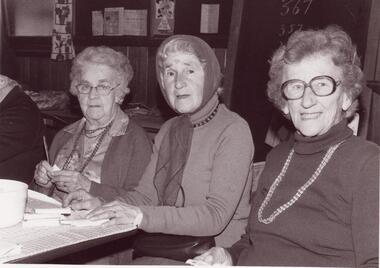
Book - Thomson Memorial Presbyterian Church Ormond
It Includes A Book Describing The History Of The Ormond Uniting Church From 1903 – 2003 Centenary Edition. The Front Cover Includes A Colour Photograph Of The Church And The Back Cover Includes A List Of The Ministers During That Time Period. The Contents Include Several Black And White Photographs And An Appendices Written By Rev Bill Morgan, Rev. Rod Horsfield, Rev. Robert Mcutchen And Rev. John Lamont, On What Ormond Means To Them. A Black And White Photograph Of Three Ladies Attending The Ormond Uniting Church Drop In Centre On The Corner Of North And Booran Roads, Caulfield 1984.ormond uniting church, anthony street, centenary edition, merton hall, anglican, maud street, presbyterian, wheatley road, methodist, ocean street, saint cuthberts, beattie james rev., jones hugh rev, chalinor john rev., hadley vincent rev., broughton david rev., morgan william rev., mcutchen robert rev., lamont john rev., horsfield rod rev., tregear george rev., kirkside independant living units, uniting church inaugurated, kids of the uniting church australia, kuca, after school program, saint kevins catholic church, father crimin, caulfield adult learning centre, daley daniel rev., green kevin rev, probin david rev, glen orme avenue, ormond, caulfield, plaza cinema, north road, manse, booran road, sunday school, glen orme, melane’s corner, ladies church aid, ladies guild, dromana, playgroup, ucaf, booran road hall, fraser street hall, mordialloc, ormond park, new hall, reid christina rev., lamont john rev -
Glen Eira Historical Society
Letter - Balaclava Road Primary School No. 3820
Caulfield North Primary School (formerly Central School) documents: 80th anniversary Commemorative Yearbook, 1914 – 1994, includes reasons why school was built, local history, reprinted ephemera relevant to school history, letters from past students. Correspondence from the Education Department, Melbourne to Town clerk, Town of Caulfield, dated 14/12/1912 and 21/07/1913 about the establishment of the school.caulfield north, caulfield melbourne, balaclava state school, caulfield north primary school, aznavorian roger, school houses, caulfield north central school, hawthorn road., balfour james, education department, cro bakery, jowett f. mr., melbourne, miller edward d & a computers, caulfield north state school, caulfield jewellers, balaclava road, education department