Showing 887 items
matching road crossing
-
 Eltham District Historical Society Inc
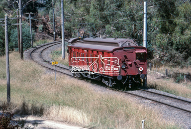
Photograph, Single Motor Carriage 471M (Red Rattler) Tait train heading to Hurstbridge just before crossing over the Diamond Creek north of Allendale Road, January 1983, 1983
Digital TIFF file Scan of 35mm Kodachrome colour positive transparency in cardboard slide mount.Processing date Feb 1983allendale road, diamond creek, george coop collection, hurstbridge line, red rattler, red rattler single carriage, single carriage train, single motor carriage, tait train -
 Eltham District Historical Society Inc
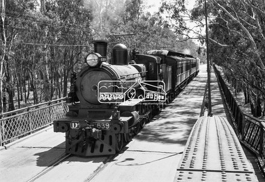
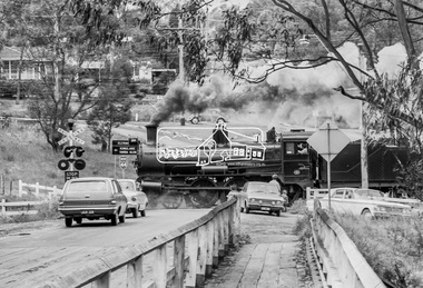
Photograph, VR Commissioner's Special train, steam locomotive D3-639 crossing the Echuca-Moama Road Rail Bridge over the Murray River from Moama, NSW to Echuca, Victoria, 1962
... crossing the Echuca-Moama Road Rail Bridge over the Murray River... crossing the Echuca-Moama Road Rail Bridge over the Murray River... crossing the Echuca-Moama Road Rail Bridge over the Murray River ...VR Commissioner's Special train, steam locomotive D3-639 crossing the Echuca-Moama Road Rail Bridge over the Murray River from Moama, NSW to Echuca, Victoria. Commissioner Edgar Henry Brownbill on footplate, 1962. Commissioner Edgar Henry Brownbill was in office 1957 to 1967. George Coop advises - "The train on the Eltham/Moama bridge is actually the Commissioner’s Special on one of its inspection tours of the VR rail system. This was a very grand special train with accommodation for the Commissioner and staff in carriages also used once for the Royal Train and other State purposes. You can just see the Commissioner of the day, dressed in his suit and wearing engine drivers gloves, standing in the loco cab doorway. A good ‘hands on’ impression is created amongst local staff if can be seen that the boss is no ‘desk jockjey’. The observation car on the back was originally made for the ’Spirit of Progress’. I climbed up onto the bridge iron plate work to get this view. It was safe enough as the cantilevered pedestrian walkway was still on the east side at the time." "I was resident in Echuca from Jan. ’59 to approx. May ’64. At that time the single Echuca/Moama bridge was a combined road/rail bridge. The rail gauge was 5’3” and still is, I believe, on the new bridge that sits just upstream of the old one. This rail line into NSW has always been 5’3" gauge because it has no connection with any NSW tracks. The old Echuca/Moama bridge, locally called the ‘Iron Bridge’ has, over years, undergone some structural changes. The two lattice iron hoops arcing over the roadway have been raised and lowered and changed design. Presently a pedestrian walkway is cantilevered off the west (or downstream) side of the bridge. It used to be on the eastern side. Guess changes went in when new rail bridge only was built on the eastern side as well." Image dated as c.1963 based on same image in Port of Echuca collection (possibly frame 32 of film) (print 19.5 x 24.5cm) On reverse in pencil: "Brown card" in black pen: "Commissioners special. F. Brown on Footplate. George C.L. Coop c1963". https://victoriancollections.net.au/items/59d575b921ea6e1278d78042 However based on frame no. 10, date set as 1962Digital TIFF file Scan of 35mm Ilford FP3 black and white negative transparencyd3-639, d3-class steam locomotive, echuca-moama road rail bridge, edgar henry brownbill, george coop collection, murray river, vr commissioner's special train -
 Eltham District Historical Society Inc
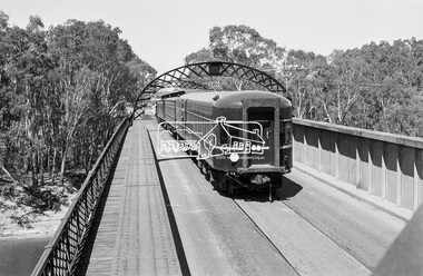
Photograph, VR Commissioner's Special train, steam locomotive D3-639 crossing the Echuca-Moama Road Rail Bridge over the Murray River from Moama, NSW to Echuca, Victoria, 1962
... crossing the Echuca-Moama Road Rail Bridge over the Murray River... crossing the Echuca-Moama Road Rail Bridge over the Murray River ...Looking south into Echuca, VictoriaDigital TIFF file Scan of 35mm Ilford FP3 black and white negative transparencyd3-639, d3-class steam locomotive, echuca-moama road rail bridge, george coop collection, murray river, vr commissioner's special train -
 Eltham District Historical Society Inc
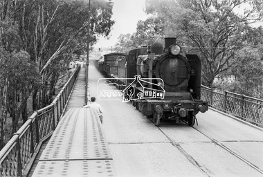
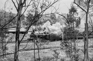
Photograph, Steam locomotive K-168 crossing the Echuca-Moama Road Rail Bridge over the Murray River, c.May 1963, 1963
... Steam locomotive K-168 crossing the Echuca-Moama Road Rail... locomotive K-168 crossing the Echuca-Moama Road Rail Bridge over ...Looking south into Echuca, VictoriaDigital TIFF file Scan of 35mm Ilford FP3 black and white negative transparencyechuca-moama road rail bridge, george coop collection, k-168, k-class steam locomotive (vr newport workshops), murray river -
 Eltham District Historical Society Inc
Book, Diamond Creek Basin Study. Part 1, A Compendium of Factors Relevant to Stormwater Flows, 1980
Basin Studies are studies to evaluate water supply and demand and help ensure reliable water supplies by identifying strategies to address imbalances in water supply and demand.Spiral Bound. 157 leaves in various foliations (some folded) : illustrated. (some colour.), maps (some colour.)aerial photographs, allendale road, arthurs creek mine, arthurs creek road bridge, arthurs creek, bald spur look-out, bank protection, bolton steet, bridge street bridge, bridge street, bridges, challenger street, chute street, construction, coolaroo drive, culvert, deep creek, diamond creek basin, diamond creek region, diamond creek, diamond street bridge, drainage works, eltham lower park, eltham town park, eltham trestle bridge, eltham west drains, eltham, erosion, flood management, floods, footbridge, glen katherine estate, gold mining, gum glade, hurstbridge, kangaroo ground, kinglake escarpment, kinglake national park, latiners hat factory, main road bridge, main road, masons falls, melbourne metropolitan board of works, monash bridge, mount sugarloaf, nillumbik park, orchards, railway culvert, railway line, ramptons road, real estate advertisement, research creek, st helena east drain, st helena road, st helena, storm sewers, stormwater, sugarloaf-preston transfer main crossing, susan street, union mine, village pond, water flow, watkins street, wattletree road, weidlich road, wingrove park, yarra river, zig zag road, water supply, basin study -
 Eltham District Historical Society Inc
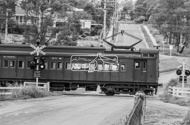
Photograph, Single Motor Carriage 471M Tait (Red Rattler) train passing through the level crossing at Wattletree Road, Eltham, c.1970, 1970
... passing through the level crossing at Wattletree Road, Eltham, c...) train passing through the level crossing at Wattletree Road ...Note the blue stone edging surrounding the grassy island in the intersection. This stone was originally part of the blue stone lock-up situated behind the Police Station and residence at 728 Main Road (present day Local History Centre and home to Eltham District Historical Society). Following a redesign of the intersection the stone was again relocated back to 728-730 Main Road for use as garden edging.Digital TIFF file Scan of 35mm Ilford HP4 black and white transparency471m, 728 main road, local history centre, lockup, police station, red rattler, single motor carriage, tait train, wattletree road -
 Eltham District Historical Society Inc
Photograph, Steam locomotive D639 with Tait (Red Rattler) carriages approaching the level crossing at Wattletree Road, Eltham, c.1970, 1970
... approaching the level crossing at Wattletree Road, Eltham, c.1970... the level crossing at Wattletree Road, Eltham, c.1970 Photograph ...Railway Parade (unsealed) in foreground.Digital TIFF file Scan of 35mm Ilford HP4 black and white transparencyd-639, railway parade, red rattler, steam engine, tait train -
 Eltham District Historical Society Inc
Photograph, Steam locomotive D639 with Tait (Red Rattler) carriages passing through the level crossing at Wattletree Road, Eltham bound for Hurstbridge, c.1970, 1970
... passing through the level crossing at Wattletree Road, Eltham... as garden edging. 728 main road, d-639, eltham, level crossing ...Note the blue stone edging surrounding the grassy island in the intersection. This stone was originally part of the blue stone lock-up situated behind the Police Station and residence at 728 Main Road (present day Local History Centre and home to Eltham District Historical Society). Following a redesign of the intersection the stone was again relocated back to 728-730 Main Road for use as garden edging.Digital TIFF file Scan of 35mm Ilford HP4 black and white transparency728 main road, d-639, eltham, level crossing, local history centre, lockup, main road, police station, railway parade, red rattler, steam engine, wattletree road, wattletree road bridge -
 Eltham District Historical Society Inc
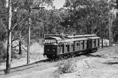
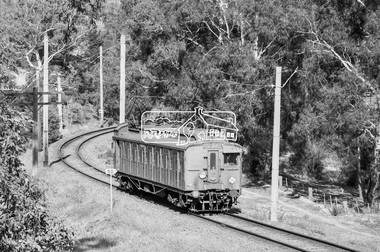
Photograph, George Coop, Single Motor Carriage 471M Tait (Red Rattler) train heading for Hurstbridge, possibly near the Diamond Creek crossing just north of Allendale Road, c.1980, 1980
Digital TIFF file Scan of 35mm Ilford XP1 black and white transparency471m, allendale road, diamond creek, hurstbridge line, red rattler, red rattler single carriage, single motor carriage, tait train -
 Eltham District Historical Society Inc
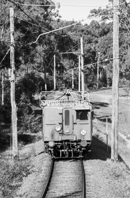
Photograph, George Coop, Single Motor Carriage 471M Tait (Red Rattler) train heading for Eltham, possibly near the Diamond Creek crossing just north of Allendale Road, c.1980, 1980
Digital TIFF file Scan of 35mm Ilford XP1 black and white transparency471m, allendale road, diamond creek, hurstbridge line, red rattler, red rattler single carriage, single motor carriage, tait train -
 Eltham District Historical Society Inc
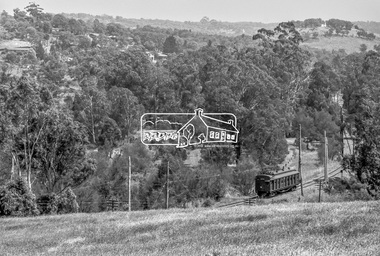
Photograph, George Coop, Single Motor Carriage (Red Rattler) Tait train, possibly 471M, heading for Eltham near Allendale Road, Diamond Creek, c.December 1980, 1980
View is looking northwest from the hillside just north of Allendale Road. The long rectangular house in the upper left is No. 22 Challenger Street, Diamond Creek, right at the sharp turn into Price Court. On the track in the straight section heading northwest are two small bridges where the track crosses the Diamond Creek, each fitted with derailment guard rails to prevent severe derailments should a train come off the tracks whilst crossing the culverts. Digital TIFF file Scan of 35mm Ilford FP4 black and white transparency471m, allendale road, challenger street, derailment guard rail, diamond creek, hurstbridge line, price court, red rattler, red rattler single carriage, single motor carriage, tait train -
 Eltham District Historical Society Inc
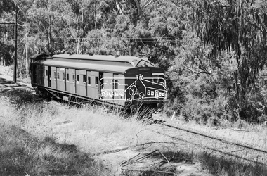
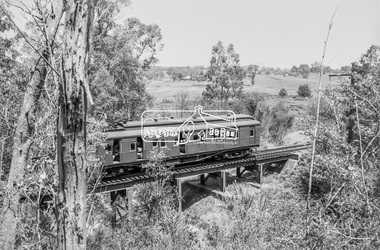
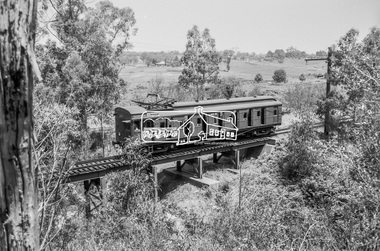
Photograph, George Coop, Single Motor Carriage 471M (Red Rattler) Tait train crossing over the Diamond Creek just north of Allendale Road, c.December 1980, 1980
Digital TIFF file Scan of 35mm Ilford FP4 black and white transparency471m, allendale road, derailment guard rail, diamond creek, hurstbridge line, railway bridge, red rattler, red rattler single carriage, single motor carriage, tait train -
 Eltham District Historical Society Inc
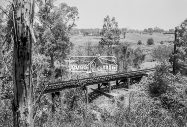
Photograph, George Coop, Railway bridge crossing over the Diamond Creek just north of Allendale Road, c.December 1980, 1980
Digital TIFF file Scan of 35mm Ilford FP4 black and white transparencyallendale road, derailment guard rail, diamond creek, hurstbridge line, railway bridge -
 Eltham District Historical Society Inc
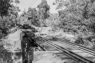
Photograph, George Coop, Single Motor Carriage 471M (Red Rattler) Tait train heading for Eltham crossing over the Diamond Creek just north of Allendale Road, c.December 1980, 1980
Digital TIFF file Scan of 35mm Ilford FP4 black and white transparency471m, allendale road, derailment guard rail, diamond creek, hurstbridge line, railway bridge, red rattler, red rattler single carriage, single motor carriage, tait train -
 Eltham District Historical Society Inc
Photograph, George Coop, Single Motor Carriage (Red Rattler) Tait train heading for Eltham crossing over the Diamond Creek just north of Allendale Road, c.1981, 1981
Digital TIFF file Scan of 35mm Ilford FP4 black and white transparencyallendale road, derailment guard rail, diamond creek, railway bridge, single motor carriage, tait train -
 Eltham District Historical Society Inc
Photograph, George Coop, Single Motor Carriage 473M (Red Rattler) Tait train heading to Hurstbridge just before crossing over the Diamond Creek north of Allendale Road, 17 July 1983, 1983
Digital TIFF file Scan of 35mm Ilford FP4 black and white transparencyallendale road, diamond creek, hurstbridge line, red rattler, red rattler single carriage, single motor carriage, tait train -
 Eltham District Historical Society Inc
Photograph, Hume and Hovell passed here at Seymour 28 Oct 1824, Spring Excursion, Hume and Hovell's 1824 expedition (Part 2), 26 October 1997, 26/10/1997
[article by Diana Bassett-Smith in EDHS Newsletter No. 117, November 1997:] MONUMENT HUNTING THE HUME AND HOVELL WAY - Sunday October 26 1997 dawned bright and very warm. Some twenty-five members, complete with picnic baskets, met outside the Eltham Library awaiting the Cobb and Co. large coach which would be taking us on the second leg of our travels along the route of the early explorers Hume and Hovell. Stephen West was our very good driver for the day. He would be guided around the circuitous route by Russell Yeoman who had made a detailed study, not only of the intended route, but of the story of these two explorers. During the trip Russell regaled us with poetry, quotations from the Journals and the History of the Shire of Seymour, "The New Crossing Place" by Martindale, 1982, (now Mitchell Shire due to the recent amalgamations). We headed towards the Hume Highway via Greensborough and Cooper Street and proceeded north to our first stop, noting on the way Monument Hill in the distance which is near Kilmore and, according to Russell, well worth the effort to visit as the view across the valley is magnificent. Past Sunday Creek Valley, Mt Piper and Mt Disappointment, all traversed and noted and named by them. We passed through Tallarook, then onto Seymour where we took photos of the monument telling us that Hume and Hovell had passed through on the 28th of October 1824. We also deviated down Hume and Hovell Road viewing deer and emu farming and the Bellbourie property now a sanctuary. Leaving Seymour behind we travelled up the Avenel Road to the Avenel monument, pyramidal in design of four reducing square blocks with a sharply pointed peak, erected in 1924 in memory of the 1824 exploration. The day was warming up and the countryside showing the dryness of the current drought. A parallel note had been made in their journal too of 1824 of the drought appearance of the country they were traversing. At Seven Creeks, Euroa we stopped for some minutes to check the monument placed 20th November 1924 to commemorate their passage on the 29th December 1824. More photos. Russell had pointed out the abrupt termination of the distant ranges which is noted in their journal. The next monument is beside the road at the entrance to Honey Suckle Creek Caravan Park, Violet Town. The squarish shaped monument some eight feet high is topped with a simple steel cross, and was to mark the date of 28th December 1824 and built for the 20th November 1924. By now it was 12.20 and nearly lunchtime as we drove along the Warranbayne Road to Roach's Road, monument hunting without success. Though there is a large, what appears to be an old timber sign which was hard to read, maybe this was the lost monument. In many of the paddocks hay had been cut and baled or was being cut, what a contrast to the rugged country they had passed through which was smoky from the fires of the natives burning off. By 1.00 pm we were at Benalla and pulled up beside the park where abundant beds of roses filled the air with their scent and the smell of barbecued food twitched the nostrils whilst the cheerful sounds of other picnickers could be heard throughout the park. We left the bus and collected up our picnics, dispersed to the various tables and enjoyed the shade from the various European trees. 2.00 pm and we were on the road again driving along the Benalla, Mansfield, Yea road. The Swanpool monument states that they passed four miles south and returned three miles north. Then we stopped at the Barjarg monument which notes that they camped near this spot. It is again a pyramidal monument and this time topped with a steel arrow indicating their route of the 29th November 1824. Half an hour later we came to another monument, again with a steel arrow marker on top and the plaque dated the 2nd of 12th 1824. Erected on the 12th of 12th 1924. "They blazed the way that we might inherit the land." Another square based and needle topped monument appeared at Yarck near Yea and this plaque records the date of 3 December 1824. Near McGuigans Road Russell related that the expedition had lost a dog but it had found them next day, the dog was apparently torn by a kangaroo. A short while later Russell reminded us here of the problems they encountered in crossing the Goulburn River near Molesworth where banks were high, water deep and wide. "Good coat of grass but quite dry due to drought". At Yea we stopped for afternoon tea and raided the last of our picnics and looked at the monument to their journey of 1824, situated at a corner of the gardens near the bowling green. No photo – we were out of film. We returned home via Kinglake West and Whittlesea past the Yan Yean Reservoir, not full. 5.00 pm back at Eltham we emptied out of the bus and everyone, including Joan Cole, collected their things, Joan also had the major souvenir of the day, a large carp she had picked up from the river bank, her cat was in for a great feast. The day was made so interesting by the informed commentary which Russell provided. His background knowledge of the route and nature of the journey could only have come from many hours of reading and driving the area. Thank you to Russell and to everyone who made the day so informative and pleasurable. Colour photographactivities, hume and hovell, monument, seymour -
 Eltham District Historical Society Inc
Photograph, Spring Excursion, Hume and Hovell's 1824 expedition (Part 2), 26 October 1997, 26/10/1997
[article by Diana Bassett-Smith in EDHS Newsletter No. 117, November 1997:] MONUMENT HUNTING THE HUME AND HOVELL WAY - Sunday October 26 1997 dawned bright and very warm. Some twenty-five members, complete with picnic baskets, met outside the Eltham Library awaiting the Cobb and Co. large coach which would be taking us on the second leg of our travels along the route of the early explorers Hume and Hovell. Stephen West was our very good driver for the day. He would be guided around the circuitous route by Russell Yeoman who had made a detailed study, not only of the intended route, but of the story of these two explorers. During the trip Russell regaled us with poetry, quotations from the Journals and the History of the Shire of Seymour, "The New Crossing Place" by Martindale, 1982, (now Mitchell Shire due to the recent amalgamations). We headed towards the Hume Highway via Greensborough and Cooper Street and proceeded north to our first stop, noting on the way Monument Hill in the distance which is near Kilmore and, according to Russell, well worth the effort to visit as the view across the valley is magnificent. Past Sunday Creek Valley, Mt Piper and Mt Disappointment, all traversed and noted and named by them. We passed through Tallarook, then onto Seymour where we took photos of the monument telling us that Hume and Hovell had passed through on the 28th of October 1824. We also deviated down Hume and Hovell Road viewing deer and emu farming and the Bellbourie property now a sanctuary. Leaving Seymour behind we travelled up the Avenel Road to the Avenel monument, pyramidal in design of four reducing square blocks with a sharply pointed peak, erected in 1924 in memory of the 1824 exploration. The day was warming up and the countryside showing the dryness of the current drought. A parallel note had been made in their journal too of 1824 of the drought appearance of the country they were traversing. At Seven Creeks, Euroa we stopped for some minutes to check the monument placed 20th November 1924 to commemorate their passage on the 29th December 1824. More photos. Russell had pointed out the abrupt termination of the distant ranges which is noted in their journal. The next monument is beside the road at the entrance to Honey Suckle Creek Caravan Park, Violet Town. The squarish shaped monument some eight feet high is topped with a simple steel cross, and was to mark the date of 28th December 1824 and built for the 20th November 1924. By now it was 12.20 and nearly lunchtime as we drove along the Warranbayne Road to Roach's Road, monument hunting without success. Though there is a large, what appears to be an old timber sign which was hard to read, maybe this was the lost monument. In many of the paddocks hay had been cut and baled or was being cut, what a contrast to the rugged country they had passed through which was smoky from the fires of the natives burning off. By 1.00 pm we were at Benalla and pulled up beside the park where abundant beds of roses filled the air with their scent and the smell of barbecued food twitched the nostrils whilst the cheerful sounds of other picnickers could be heard throughout the park. We left the bus and collected up our picnics, dispersed to the various tables and enjoyed the shade from the various European trees. 2.00 pm and we were on the road again driving along the Benalla, Mansfield, Yea road. The Swanpool monument states that they passed four miles south and returned three miles north. Then we stopped at the Barjarg monument which notes that they camped near this spot. It is again a pyramidal monument and this time topped with a steel arrow indicating their route of the 29th November 1824. Half an hour later we came to another monument, again with a steel arrow marker on top and the plaque dated the 2nd of 12th 1824. Erected on the 12th of 12th 1924. "They blazed the way that we might inherit the land." Another square based and needle topped monument appeared at Yarck near Yea and this plaque records the date of 3 December 1824. Near McGuigans Road Russell related that the expedition had lost a dog but it had found them next day, the dog was apparently torn by a kangaroo. A short while later Russell reminded us here of the problems they encountered in crossing the Goulburn River near Molesworth where banks were high, water deep and wide. "Good coat of grass but quite dry due to drought". At Yea we stopped for afternoon tea and raided the last of our picnics and looked at the monument to their journey of 1824, situated at a corner of the gardens near the bowling green. No photo – we were out of film. We returned home via Kinglake West and Whittlesea past the Yan Yean Reservoir, not full. 5.00 pm back at Eltham we emptied out of the bus and everyone, including Joan Cole, collected their things, Joan also had the major souvenir of the day, a large carp she had picked up from the river bank, her cat was in for a great feast. The day was made so interesting by the informed commentary which Russell provided. His background knowledge of the route and nature of the journey could only have come from many hours of reading and driving the area. Thank you to Russell and to everyone who made the day so informative and pleasurable. Colour photographactivities, hume and hovell, bridge -
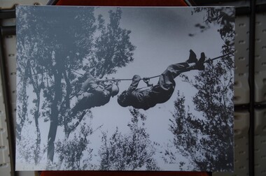 Running Rabbits Military Museum operated by the Upwey Belgrave RSL Sub Branch
Photo
Troops crossing on rope with gas maskespicture, 1970, army -
 Frankston RSL Sub Branch
Statuette, Heritage Fine Arts Pty Ltd, Vietnam, Circa 2000
A small statuette of a Vietnam era soldier in typical Australian Army jungle warfare kit. The setting represents a forward scout crossing a watercourse and silently signalling to those following 'enemy ahead' by giving the 'thumb down' hand signal. The cast pewter alloy statuette is mounted on a base of polished stone, the base being 8cm by 8cm by 5cm high. The overall height of the statuette is 15 cm.the base has the label "VIETNAM" Heritage Fine Arts, Limited to 2500 on one side of base, numbered 0143. -
 Phillip Island and District Historical Society Inc.
Photographs, 21/11/1969
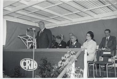
The Official Opening of Phillip Island's 2nd Bridge on November 21st, 1969. The photographs were donated by the Country Roads Board, Melbourne.Seven photographs of the Opening Ceremony of the Phillip Island Bridge on the 21st November 1969. 291-01. Photograph of Cr Bill Papworth addressing the crowd with Official party in the background. 291-02. Photograph of Hon. M. V. Porter & wife cutting the ribbon. 291-03. Photograph of official cars crossing the bridge. 291-04. Photograph of the crowd on the bridge. 291-05. Photograph of Official party and speech by Hon. M. V. Porter. MLA 291-06. Photograph of Mrs Porter cutting the ribbon. 291-07. Photograph of Official Party and speakers.opening of 2nd phillip island bridge, official bridge opening, crb -
 Greensborough Historical Society
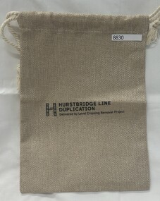
Memorabilia - Bag, Hurstbridge Line Duplication : delivered by Level Crossing Removal Project, 2023
Given out at the opening of Montmorency Railway Station 2023.Draw string fabric bag.'H' Hurstbridge Line Duplication; Delivered by Level Crossing Removal Project.bags, montmorency railway station, montmorency station, hurstbridge rail line upgrade -
 Greensborough Historical Society
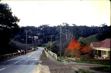
Slide, Fred Harris, Main Street, old river bridge Greensborough, 1949c
Taken about 1949, this colour slide shows Main Street Greensborough crossing the Plenty River via the 'old' bridge.1 photographic slide in yellow Kodak packet.Name of donor and title of slide written on outside of packetmain street greensborough, plenty river, main street bridge -
 Greensborough Historical Society
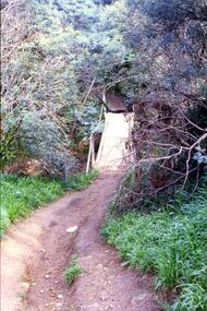
Slide - Photograph, John Ramsdale, Crossing Plenty River: Slide 12, 1990s
Photograph shows erosion on a path to a footbridge over the Plenty River down from George Court Montmorency.Part of the John Ramsdale collection of slides and audio visual material.Colour photograph scanned from slide.No maker's marks. No caption on slide.plenty river, erosion, montmorency -
 Greensborough Historical Society
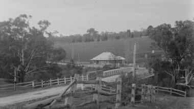
Photograph - Digital Image, Plenty Bridge Hotel, Lower Plenty, 1870s
Lower Plenty Hotel. This photograph shows the original Plenty Bridge hotel with Lower Plenty bridge in the foreground. The hotel was built c1858 and the bluestone bridge in the 1860s to replace the earlier toll bridge built in 1858.The close proximity of the hotel to the bridge is an indication of the importance of these river crossings in the mid 19th centuryDigital copy of black and white photographlower plenty, plenty river, plenty bridge hotel, lower plenty bridge, lower plenty hotel -
 Greensborough Historical Society
Photograph - Digital Image, Watsonia Railway Station 1975, 1975_
Watsonia rail line being moved below road level mid 1970s. This photograph shows work on the cutting and beginning of station. Watsonia Station was opened in 1977 when the rail line was lowered to remove level crossings and duplicate the line between Macleod and Greensborough.Digital copy of colour photographwatsonia station, hurstbridge rail line -
 Greensborough Historical Society
Photograph - Digital Image, Watsonia Railway Station before 1970, 1960s
Watsonia Station before the 1970s. This photograph shows the old station. The new Watsonia Station was opened in 1977 when the rail line was lowered to remove level crossings and duplicate the line between Macleod and Greensborough.Digital copy of black and white photographwatsonia station, hurstbridge rail line -
 Greensborough Historical Society
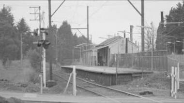
Photograph - Digital Image, Watsonia Railway Station before 1970, 1960s
Watsonia Station before the 1970s. This photograph shows the rail crossing at the old station. The new Watsonia Station was opened in 1977 when the rail line was lowered to remove level crossings such as this and duplicate the line between Macleod and Greensborough.Digital copy of black and white photographwatsonia station, hurstbridge rail line -
 Greensborough Historical Society
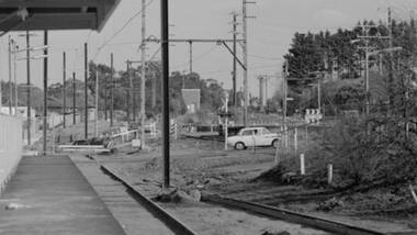
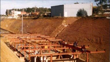
Photograph - Digital Image, Building Watsonia Station 1975, 1975_
Building Watsonia Station circa 1975. This photograph shows the framework for the new station being installed. The new Watsonia Station was opened in 1977 when the rail line was lowered to remove level crossings and duplicate the line between Macleod and Greensborough.Digital copy of colour photographwatsonia station, hurstbridge rail line